GEOHAZIS-2015 Technical Report Western Ionian - Southern Tyrrhenian seas (Sep. 1 - 15, 2015) R/V Minerva Uno
←
→
Trascrizione del contenuto della pagina
Se il tuo browser non visualizza correttamente la pagina, ti preghiamo di leggere il contenuto della pagina quaggiù
GEOHAZIS-2015 Technical Report
                                                                                         2015

                            GEOHAZIS-2015
                             Technical Report
           Western Ionian – Southern Tyrrhenian seas
                            (Sep. 1 – 15, 2015)
                            R/V Minerva Uno
                      _______________________________________

 Luca Gasperini, Giovanni Bortoluzzi, Enrico Dalpasso, Andrea Gallerani, Alessio
Cesari, Francesco Urzì, Sofia Baranello, Lorenzo Bortolini, Francesca Bulian, Mirko
  Carlini, Lorenzo Crescentini, Giovanni Di Gregorio, Zeno Lippi, Alina Polonia.
                      _______________________________________

                  ISMAR – CNR Bologna TECHNICAL REPORT n.149
                              Bologna, September 2015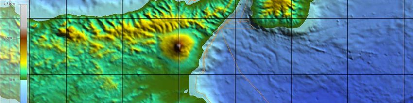
Many of the designations used by the manufacturers and sellers to promote their products are claimed as
trademarks. Where those designations appear in the Report and ISMAR-CNR was aware of a trademark
claim the designations have been printed in all caps. In addition, we have reported some of them in the
Production Notes below in this page and in the ACRONYMS table thereinafter. Nothing in this document is
meant to imply any endorsement or recommendation, positive or negative, concerning any systems or
programs mentioned herein.

The data presented hereafter is property of CNR and of Joint Research Programs. Unauthorized use of the
data should be considered unfair. Many of the systems and programs used to generate data are ’free’
because either they are either public domain or the licenses are roughly equivalent to the GNU Public
License. Some programs are either commercial or have more restrictive licenses and may require payment.
Where known, programs and systems not ‘free’ are acknowledged.

Gasperini et al. 2015. GEOHAZIS-2015 Technical Report. Wester Ionian Sea – Southern Tyrrenian seas.
Sep 1 – 15, 2015. ISMAR-CNR, Bologna TECHNICAL REPORT n.xx, pp.yy

Reproduced by ISMAR-CNR from camera-ready proofs supplied by the authors.
Available in the HTML and PDF formats. Available also in other formats, upon request.

Copyright 2015 by ISMAR-CNR - Via Gobetti 101 40129 Bologna, Italy.
          ©

                                                     [2]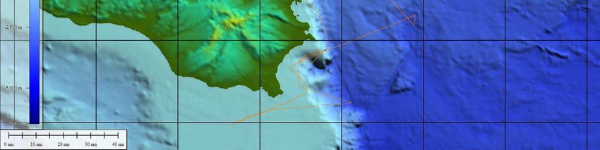
[3]
•   CNR Consiglio Nazionale Delle Ricerche www.cnr.it
   •   ISMAR Istituto di Scienze Marine www.bo.ismar.cnr.it
   •   SEG Soc. of Exploration Geophysicists www.seg.org
   •   XTF Extended Triton Format www.tritonelics.com
   •   IHO Int. Hydrographic Organization www.iho.org
   •   GPS-DGPS-RTK Global Positioning System samadhi.jpl.nasa.gov
   •   DTM Digital Terrain Model en.wikipedia.org
   •   SRTM Shuttle Radar Topogr.Mission www2.jpl.nasa.gov/srtm
   •   MBES MULTIBEAM ECHOSOUNDER SYSTEM
   •   SBP Sub Bottom Profiling
   •   PSU Practical Salinity Scale ioc.unesco.org
   •   XBT Expendable BathyTermograph www.sippican.com
   •   UTM Universal Transverse Mercator
   •   UTC Universal Time Coordinated
   •   WGS84 World Geodetic System 1984
   •   NMEA National Marine Electronics Association www.nmea.org
   •   SO.PRO.MAR. Societa’ Promozione lavori Marittimi Fiumicino (Italy)
   •   SBE Sea Bird Electronics www.seabird.com
   •   BENTHOS Teledyne Benthos www.benthos.com
   •   SIS Sea Floor Inf. System www.kongsberg.com
   •   COMM-TECH Communication Technology www.comm-tec.com
   •   GMT Generic Mapping Tool gmt.soest.hawaii.edu/gmt

Acronyms of Organizations, Manufacturers and Products

                                                     [4]
HOW TO READ THIS REPORT
Section 1 gives the introductory and background information, including some technological and scientific
issues of the organization and execution of tasks, whereas section 2 summarizes the cruise operations.
Section 3 provides the technical aspects that were involved in the data acquisition and processing. Section 4
and following discuss the initial results, the on-going data processing and usage, and give concluding
remarks. Some data processing procedures that were used in the production of this report along with
additional technical details and data are presented in the Appendix.
ACKNOWLEDGMENTS
Many people contributed to the success of the research cruise (CALAQUAKE-2012 R/V Minerva Uno). We
are particularly indebted to the Captain Pasquale Guida, the officers and crew members of R/V Minerva Uno
for their professionalism and efforts in assuring the success of the cruise. The project was co-funded by
Italian CNR and MIUR project: Geodinamica attiva e recente dell’Arco Calabro e del complesso di
accrezione nel Mar Ionio, coordinated by Carmelo Monaco (University of Catania).
[5]RIASSUNTO
Questa relazione contiene il resoconto tecnico della campagna di Geologia Marina denominata
“GEOHAZIS-2015”, effettuata tra il 1 e il 15 Settembre nel Mar Ionio Occidentale e Mar Tirreno
Meridionale. Durante la spedizione GEOHAZIS-2015 sono stati acquisiti dati di sismica a
riflessione singolo- e multi-canale, morfobatimetria e magnetometria, e sono stati campionati i
sedimenti marini utilizzando un carotiere a gravità con leva di sgancio. Scopo principale della
campagna era studiare la geologia dell’Arco Calabro (AC) e le connessioni tra questo e l’arco
vulcanico delle Isole Eolie. L’AC è una struttura litosferica di subduzione che si sviluppa al largo
della Sicilia Orientale e della Calabria. La sua struttura è segmentata da numerose faglie attive che
mostrano un grande potenziale sismogenico e che hanno causato terremoti e tsunami disastrosi nel
recente e più remoto passato, come nel caso di Messina nel 1908 e del Golfo di Augusta nel 1693.
Nel corso di GEOHAZIS-2015 sono stati raccolti dati di dettaglio sulle principali faglie attive che si
propagano dall’entroterra siciliano alla piattaforma continentale, dove la presenza di una
sedimentazione più continua permette di applicare a queste faglie i metodi della paleosismologia
sottomarina per ricostruirne l’attività alla scala del singolo evento e di diversi cicli sismici, su una
scala temporale che comprende almeno gli ultimi 10-20 mila anni.
ABSTRACT
This is the technical report of the "GEOHAZIS-2015" oceanographic expedition, carried out during
the period October 1st to 15 in the Western Ionian Sea – Southern Tyrrenian. During
CALAQUAKE-2012, several type of marine geological data were collected, including: single- and
multichannel seismic reflection profiles, morphobathymetric and magnetic data, as well as sediment
cores in key areas of the Sicilian continental margin. The main purpose of the campaign was to
study the geology of the Calabrian Arc, the subduction system offshore of eastern Sicily and
Calabria, its shallow-crustal structure, and the seismogenic potential of the active faults that have
caused earthquakes and tsunamis in the recent and more remote past, as in the case of Messina in
1908 and the Gulf of Augusta in 1693. In particular, during GEOHAZIS - 2015 we collected
detailed data on the active fault systems, which propagate from the Sicilian inland to the continental
shelf, where the presence of a more continuous sedimentation allows to apply methods of the
submarine paleoseismology to reconstruct the activity of seismogenic faults at the scale of a single
event and of several seismic cycles, over time scales encompassing the latest 10-20 thousand years.
[6]Contents
1. SOMMARIO DELLA CAMPAGNA
2. CRUISE SUMMARY
3. IL PROGETTO GEOHAZIS
4. METHODS
5. RESULTS
6. CONCLUDING REMARKS AND FUTURE WORKS
LIST OF FIGURES
1. Figure 1. The R/V Minerva Uno
2. Figure 2. Example of Chirp-Sonar profile collected in the study area, showing active faults
3. Figure 3. The 1.2T gravity corer armed before a coring
4. Figure 4. Main panel of magnetic susceptibility acquisition software
5. Figure 5. Chirp sonar and multibeam acquisition lines off Eastern Sicily in the Ionian Sea
6. Figure 6. Data collected in the Southern Tyrrhennian offshore Milazzo during
GEOHAZIS-2015.
LIST OF TABLES
1. Table 1. Instrumental offsets of PDS2000 onboard R/V Minerva Uno.
2. Table 2. List of participants to GEOHAZIS-2015
3. Table 3. Location of the coring stations performed during GEOHAZIS-2015. Recover and
penetration at each station are also indicated
[7]1. SOMMARIO DELLA CAMPAGNA
La Campagna di ricerca oceanografica GEOHAZIS-2015 ha avuto luogo a bordo della R/V
Minerva Uno dal 1 al 15 Settembre nelle acque del Mare Ionio occidentale e Mare Tirreno
meridionale.
Il progetto comprendeva originariamente aree di lavoro in alcuni settori di scarpata continentale
e piana abissale del complesso di subduzione dell’Arco Calabro, al largo della Calabria Meridionale
e della Sicilia Orientale, in profondità comprese tra poche le centinaia e i 3-4 mila di profondità
(vedi progetto richiesta nave Polonia-2014).
Il tragico incidente occorso alla Nave Oceanografica Urania, a bordo della quale era
programmato il lavoro, ha reso necessario ripiegare sulla Nave Oceanografica Minerva Uno, che si
è dimostrata molto valida, ma dotata di strumenti non in grado di effettuare rilievi a profondità così
elevate.
Si perciò reso indispensabile rimodulare gli obiettivi della campagna includendo solo aree di
piattaforma continentale e scarpata superiore, entro l’isobata dei -1000 m, focalizzando lo studio su
aree marginali rispetto agli obiettivi principali.
.
2. CRUISE SUMMARY
The GEOHAZIS-2015 scientific cruise took place aboard the R/V Minerva Uno from 1st to
15th September, in the waters of the Western Ionian – Southern Tyrrhenian seas.
The project originally included areas of the continental slope and abyssal plain of the complex
subduction of the Calabrian Arc, off the coast of southern Calabria and eastern Sicily, in depths
between a few hundreds to 3-4 thousand meters deep (see project ship proposal Polonia-2014). The
tragic accident of the R/V Urania, on board of which the cruise was originally scheduled, made it
necessary to fall back on the R/V Minerva Uno, which has proved very effective, but not equipped
with instruments able to perform measurements at such a high depths.
It therefore made necessary reformulate the objectives of the campaign including only areas of the
continental shelf and upper slope, within the -1000 m isobath, where we focused our work.
[8]3. IL PROGETTO GEOHAZIS
Il progetto di ricerca GEOHAZIS prevede l’analisi dei processi tettonici e delle relazioni tra
sedimentazione e attività sismica in tre aree chiave dell’arco calabro (AC) individuate per mezzo
dell’ interpretazione dei dati a disposizione. Ci si propone di acquisire elementi utili alla valutazione
del rischio sismico e tsunamigenico nella regione del Mediterraneo Centrale attraverso un approccio
integrato di geologia marina che prevede l’analisi di dati geofisici a diverse risoluzioni e l’analisi
stratigrafica della successione sedimentaria recente prelevata in prossimità delle faglie attive.
L’AC è una delle zone italiane sismicamente più attive e rappresenta l’ultima regione del
Mediterraneo Centrale dove la subduzione della placca africana potrebbe essere ancora attiva.
Questa regione è stata interessata da una sequenza di grossi terremoti storici come quelli del 1169,
1542, 1624, 1693, 1783, 1905, 1908 spesso associati a devastanti tsunami. Solo il terremoto di
Messina ha provocato piu’ di 100,000 vittime.
I risultati ottenuti attraverso l’analisi dei dati acquisiti durante la precedente campagna Urania-
2008 (progetto CALAMARE: CALabrian Arc MARrine geophysical Experiment) e
CALAQUAKE-2012 e -2014, costituiscono la base scientifica di questa nuova proposta. La
struttura e l’evoluzione del complesso di subduzione dell’AC esterno sono state ricostruite
attraverso l’analisi integrata di dati geofisici a diverse risoluzioni. La struttura regionale del
complesso di subduzione (profondità dello scollamento basale e sue variazioni, geometria e stile
strutturale dei vari domini morfotettonici, posizione e geometria delle faglie principali) è stata
ricostruita grazie all’interpretazione di profili sismici migrati in profondità (Pre-Stack Depth
Migrated - PSDM); la struttura di dettaglio del prisma di accezione e di rami di faglia attivi è invece
stata ricostruita attraverso l’analisi integrata di profili sismici multicanale ad alta risoluzione, profili
sub-bottom CHIRP e multibeam acquisiti in aree chiave del complesso di subduzione.
Questo approccio multiscala e multidisciplinare ha permesso di ricostruire quattro domini
strutturali principali del complesso di subduzione caratterizzati da diversi processi tettonici, quali
l’accrezione frontale (prisma post-Messiniano), sovrascorrimenti fuori sequenza e undeplating
(prisma pre-Messiniano) e tettonica sia distensiva che compressiva (inner plateau) [Polonia et al.,
2011].
Sebbene manchi una sismicità con meccanismi focali di tipo compressivo lungo il piano di
subduzione nella parte esterna del sistema, è stata ricostruita deformazione attiva in diversi settori
del prisma sia lungo il fronte che sui sovrascorrimenti fuori sequenza nel settore più interno. Questo
potrebbe implicare che la subduzione è ormai cessata e il raccorciamento è legato alla convergenza
tra le placche senza una placca che sottoscorre all’altra, oppure che la subduzione è attiva ma
asismica o caratterizzata da terremoti con tempi di ricorrenza molto lunghi.
I risultati ottenuti nella prima fase del progetto sono molto promettenti perché hanno permesso
di individuare le strutture tettoniche potenzialmente responsabili dei grossi terremoti passati che
potrebbero essere sede anche di eventi futuri.
Per studiare in maggior dettaglio queste implicazioni abbiamo pianificato uno studio di
dettaglio di due aree chiave del margine siciliano Orientale e Settentrionale, dove le faglie
sismogeniche si collegano al prisma di accrezione interno, attraverso un approccio integrato di
geofisica e geologia marina che prevede l’acquisizione e l’analisi integrata di dati sismici a varie
risoluzioni, dati morfobatimetrici e carote di sedimento a gravità e pistone.
L’analisi stratigrafica, sedimentologica, geochimica e petrografia dei campioni di sedimento
acquisiti in prossimita’ delle faglie attive ha la potenzialità di ricostruire il record dei grossi
terremoti passati nella regione. Questa tecnica è stata applicata con successo in studi precedenti
(Polonia et al. 2011; 2014), e mostra il potenziale di ricostruire la attività simogenica delle faglie
includendo tempi molto lunghi (10-20 ka) che comprendono diversi cicli sismici. Per la regione
dell’Italia meridionale esiste un catalogo dei terremoti storici che si estende indietro nel tempo di
circa 2000 anni. Se riusciamo a stabilire una relazione tra il record sedimentario ed il record della
[9]sismicità storica, allora diventa possibile estendere indietro nel tempo il catalogo degli eventi
sismici così dedotti, e ricostruire l’attività dell’arco per tempi molto più lunghi, condizione
necessaria per verificare quali porzioni dell’arco hanno sperimentato grosse rotture nel passato e
quale è il tempo di ricorrenza degli eventi principali.
[10]4. METHODS
The research cruise was carried out with the 41 meter-long R/V Minerva Uno (Figure 1), owned and
operated by SO.PRO.MAR. The ship is employed for geological, geophysical and oceanographic work in the
Mediterranean Sea and adjoining waters, including but not limited to, the Black Sea. R/V Minerva Uno is
equipped with DGPS and SEAPATH positioning system (satellite link by FUGRO), single-beam and
multibeam bathymetry and integrated geophysical and oceanographic data acquisition systems, including
ADCP, CHIRP SBP and other Sonar Equipment, along with devices for water and sediment sampling.
Additional equipment can be accommodated on the keel or towed.
Figure 1 The R/V Minerva Uno
3.1 Navigation and Data Acquisition
The vessel was set for data acquisition and navigation with PDS-2000 software by RESON, interfaced
to several sensors through a multiserial and Ethernet link; among such instruments, the DGPS (Fugro), the
Simrad single-beam echosunder, the MAHRS MRU and the meteorological station. Position and depth data
were also distributed to the CTD data acquisition console.
POSITION ACROSS ALONG HEIGHT
REFERENCE POINT 0.00 0.0 0.0
DGPS 0.07 5.77 11.52
MBEAM 0.00 5.29 -4.62
MAHRS 0.0 0.0 0
CHIRP -1.00 11.80 -4.00
A-FRAME 6.5 -6.70 0.00
STERN 6.0 --6.5 0.00
Table 1. Instrumental Offsets of PDS2000 on Ship Urania (PDS2000). The GPS antenna (primary
positioning system) is located on point DGPS.
[11]CTD DATA
CTD casts were taken throughout the surveyed areas, for sound velocity analysis, and were used for
real-time MBES acquisition and post-processing. CTD casts were carried out once in a day just before the
execution of gravity coring. In order to save time, and because oceanography was not in the objectives of the
cruise, data acquisition was terminated once a stable velocity/depth function was reached. This happened
most often below 600 m of water depth.
Together with sound velocity, data of conductibility, temperature and oxygen were collected.
CHIRP SBP
SBP data was acquired by the 16 transducers, hull mounted BENTHOS (DATASONICS) Mod. CHIRP-
III profiler, with operating frequencies ranging between 2 and 7 kHz. The pulse length was selected between
5 ms and 15 msec, while the trigger rates varied from 0.25 to 1.5 seconds, depending on water depths. Data
were collected using the multiping techniques, insonifying the water column with several chirp-sonar pings.
Digital data acquired by the Communication Technology SWANPRO software, were recorded in the XTF
format on local disks and transferred on the network upon request. Backups were loaded on external HD.
Navigation data were made available to the system as lat/long by NMEA sentences of the DGPS receiver at a
rate of approximately 1 Hz or by the PDS2000’s NMEA at 1Hz. The XTF data were then converted to SEG-
Y using the SeisPrho software [Gasperini and Stanghellini, 2009], also employed for compiling BMP
images of the seismic profiles onboard. An example of Chirp-Sonar profile processed with SeisPrho is
shown in Figure 2.
Multibeam Echosounder (MBES) DATA
Swath bathymetry was collected using a RESON 7160 MBES.
The MB sonar head is positioned on the ship’s keel using a V-shaped steel frame. A Sound Velocity
probe at the keel 1m above the Sonar Head is interfaced directly to the MBES processor, thus providing the
necessary real-time data for the beam-forming. CTD casts were used for input of the sound velocity profile
to the system. All the function of the MBES are controlled by the RESON software which provide quality
control of the data and information for planning the survey.
[12]Figure 2. Example of Chirp-Sonar profile collected in the study area showing active faults.
MULTICHANNEL SEISMIC PROFILES
Two section (25 each long) of the digital solid state Geoeel (by Geometrics) streamer were employed as
seismic receiver. As seismic source, we used a Sodera S15 Water Gun, and, alternatively, a Geo-Source 200
– 400, 1.5 KJ sparker. Data were collected with the Geoeel Geomtrics digital seismometer, with the
following parameters:
-Source distance to the ship: 30 m
-Source distance to 1st phone location 75
-Phone interval 3.125
-Shot interval 6.25
-Record Length: 2 s
Sparker data were also collected using a separate single channel streamer and digitizer.
[13]SEDIMENT SAMPLING
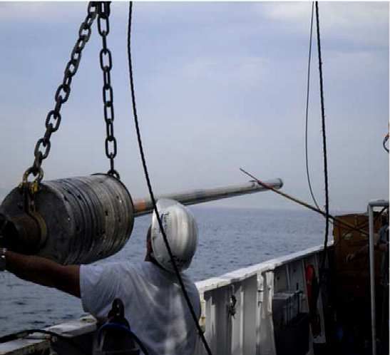
Sediment samples were collected with a 1.2 t gravity corer (Figure 3). The corer was armed with a 1.2
T of weights and one 6 m-long pipe. A trigger was used to gather the maximum impact speed of the corer at
the seafloor. Collected cores were cut onboard into 1 m-long segments and archived using the following
labelling:
GH15 (campaign name) + core_number (progressive core number) + segment_number (roman
number)
Figure 3. The 1.2 t gravity corer armed before a coring.
MAGNETIC FIELD SURVEY
Magnetic data were collected using an Overhuser proton precession magnetometer built by Marine
Magnetics. We use the acquisition software SeaSpy, which takes into account the layback, givin position
relative to POS1. The layback was 170 m and the cycle time 1 Hz.
[14]MISCELLANEA
Georeferencing of the data was performed relative WGS84 datum, in UTM33N and 34N projections
and time in UTC. Time zone was set to the UTC for the data acquisition. Positioning maps and bathymetric
images were produced with GMT [Wessel and Smith, 1991] and Global Mapper. Multibeam data were pre-
processed on board by CARIS software and ISMAR’s routines and scripts, using the SIS production DTMS,
after conversion to the ASCII format. Bathymetric data were complemented by SRTM plus data available at
the web page: topex.ucsd.edu/WWW_html/srtm30_plus.html. The computing center employed INTEL based
PC running the GNU-Linux in addition to portable computer for data acquisition and personal processing.
The Linux machines were used as data repositories using the SAMBA software, providing also network
services like WWW, DHCP and NAT. Photographs and video were taken by digital cameras and video-
camera by all participants.
[15]5. RESULTS
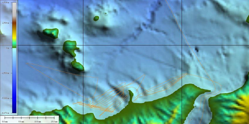
Our work focused in 2 areas:
1) The continental shelf of SE Sicily (Figure 4);
2) The continental shelf and slope of N Sicily in the Gulf of Patti and Milazzo (Figure 5)
Figure 4. Chirp sonar MCS and multibeam acquisition lines in the Western Ionian Sea off Eastern Sicily.
[16]Figure 5. Data collected in the Southern Tyrrhenian during GEOHAZIS2015. Lines indicate MB swath
bathymetry, chirp and MCS acquisition tracks.
6. CONCLUDING REMARKS AND FUTURE WORKS
Due to the late change in the Research Vessel it was not possible to achieve the main scientific
objectives of GEOHAZIS-2015. However, the ship-time was used to collect new data in interesting areas
close to the coast, which are potentially important for the purpose of the GEOHAZIS project overall
objectives. The new morphobathymetric and seismic reflection data, collected in such areas, will be used to
characterize the surficial effects of tectonic deformation and gravitative processes, which are intimately
connected in such a dynamic geological features.
However, the Calabrian Arc, despite its importance as a major structural domain in the Mediterranean
area, and its seismogenic potential, which create high hazard for the Southern Italy territory, is still only
partially covered by high-resolution marine geological and geophysical data. For this reason, and to complete
the work started with CALAQUAKE-2012, we will propose a new cruise for 2016.
[17]References
Gasperini L. and Stanghellini G. (2009). SeisPrho: an interactive computer program for processing and
interpretation of high-resolution seismic reflection profiles, Computers and Geosciences, 35,1497-
1504.
Goldfinger, C., C. H. Nelson, and J. E. Johnson (2003), Deep-water turbidites as Holocene earthquake
proxies: the Cascadia Subduction Zone and northern San Andreas Fault systems. An. Geophys. 46,
1169–1194.
Polonia, A, L. Torelli, P. Mussoni, L. Gasperini, A. Artoni, and D. Klaeschen (2011). The Calabrian Arc
subduction complex in the Ionian Sea: Regional architecture, active deformation, and seismic hazard.
TECTONICS, VOL. 30, TC5018, doi:10.1029/2010TC002821, 2011.
Wessel, P., and Smith W.H.F., 1991, Free software helps map and display data, EOS Trans. Amer.
Geophys. U., 72, 41, 445-446.
[18]Table 2
List of Participants to GEOHAZIS-2015
Luca Gasperini ISMAR-Bo (Capo Spedizione)
Giovanni Bortoluzzi ISMAR-Bo
Andrea Gallerani ISMAR-Bo
Enrico Dal Passo ISMAR-Bo
Mirko Carlini Università di Parma
Sofia Baranello Università di Bologna
Lorenzo Bortolini Università di Bologna
Francesca Bulian Università di Bologna
Lorenzo Crescentini Università di Bologna
Giovanni Di Gregorio Università di Bologna
Zeno Lippi Università di Bologna
[19]Table 3
Coring Stations performed during GEOHAZIS-2015
L. cavo Alt. Penetraz.
ID Imbando Recupero Lat/Long
sgancio Caduta M
Prof. M
037°54.4982'N
GH15-01 11 3 14 0.2 solo naso 015°21.5759'E
037°54.9519'N
GH15-02 11 3 14 0 solo naso 015°21.4893'E
037°08.2286'N
GH15-03 11 3 14 8 5.45 015°54.1645'E
036°34.6469'N
GH15-04 11 3 14 3.5 2.4 015°03.5502'E
036°37.2071'N
GH15-05 11 3 14 4.3 2.78 015°33.1868'E
038°12.2432'N
GH15-06 11 3 14 8 4.68 015°06.6486'E
038°12.4135'N
GH15-07 351 11 3 14 8 4.96 015°06.9539'E
038°12.5456'N
GH15-08 305 11 3 14 8 3.78 015°07.1516'E
[20][21]
COMM. N°: 13-15
OGGETTO DEI LAVORI: RILEVAMENTI SISMICI MULTICANALE E MAGNETOMETRIA DI SUPERFICIE                                            . CAROTAGGI ,PROFILI
CHIRP E MB. PROFILI CTD PER VELOCITÀ DEL SUONO .
                                                                                 AREA                        DI                       LAVORO:
NAVE:                           CAMPAGNA: GEOHAZIS_2015                          Tirreno, Ionio
R/V MINERVA UNO                 DAL: 01/09/2015 AL: 15/09/2015

Strumenta Utilizzata Sistema di navigazione PDS2000, ecoscandaglio EK 60, ecoscandaglio multibeam 7160,
CTD sensoristica Sbe911Plus SN: 0915, temperatura sn5022, conducibilità sn3485, Oxy sn1499, termosalinografo SBE 21. Theledyne
benthos Chirp III. Sparker Geospark 1500. Magnetometro Geometrics G822

DATA           SOMMARIO ATTIVITÀ                                                                                                      COND. METEO
01/09/201      Fermi in porto a Napoli. Imbarco dei tecnici Alessio Cesari e Francesco Urzì. Imbarco strumentazione scientifica e
               ricercatori. MOB strumentazione. Partenza dal porto di Napoli alle ore 18:30. Ora 22:30 effettuata calata CTD
5              “CTD01” per il profilo della velocità del suono. Acquisizione dati MBES e CHIRP. Trasferimento verso area di           CALMO
               lavoro.
02/09/201
               In area di lavoro si effettuano operazioni di profili CTD ore 13:30 “CTD02” per SVP profili MB e Chirp III. Nel
5              pomeriggio si effettuano 2 carotaggi con carotiere di 6m. MOB sistema per acquisizione sismica multicanale
                                                                                                                                          CALMO

03/09/201      Acquisizione dati MBES, CHIRP, sismica multicanale e magnetometria di superficie. Ore 09:30 effettuata calata

5              CTD “CTD03” per il profilo della velocità del suono. Nel pomeriggio effettuati carotaggi da 6 mt con il carotiere          CALMO
               a gravità

04/09/201      Acquisizione dati MBES, CHIRP, sismica multicanale e magnetometria di superficie. Nel pomeriggio effettuati

5              carotaggi da 6 mt con il carotiere a gravità. Ore 21:30 effettuata calata CTD “CTD04” per il profilo della velocità      MODERATO
               del suono.

05/09/201
               Acquisizione dati MBES, CHIRP, sismica multicanale e magnetometria di superficie. effettuati carotaggi da 6 mt
5                                                                                                                                         CALMO
               con il carotiere a gravità.. Ore 18:15 si effettua calata CTD “CTD05” per profili di velocità del suono

06/09/201
               Acquisizione dati MBES, CHIRP, sismica multicanale e magnetometria di superficie. Nel pomeriggio effettuati
5                                                                                                                                         CALMO
               carotaggi da 6 mt con il carotiere a gravità

               Acquisizione dati MBES, CHIRP, sismica multicanale, ore 05:30 recupero a bordo del sistema multicanale e
               inizio trasferimento verso il golfo di Milazzo dove vi è previsto sbarco e imbarco del personale scientifico.Ore           CALMO
07/09/2015     11:00effettuata calata CTD “CTD06” per profili di velocità del suono.

               Acquisizione dati MBES, CHIRP, sismica multicanale e magnetometria di superficie. trasferimento verso il porto di
08/09/2015     Milazzo dove vi è prevista una sosta per condizioni meteo avverse. Ore 22:15 fermi in porto.
                                                                                                                                       CALMO /STBY

09/09/201
5              Fermi in porto a Milazzo per condizioni meteo avverse                                                                       STBY

10/09/201
               Fermi in porto a Milazzo per condizioni meteo avverse. Ore 20:00 partenza dal porto di Milazzo direzione area di
5              lavoro. In area di lavoro si effettuano operazioni di sismica multicanale,magnetometria di superficie. Ore 21:00 si     STBY /CALMO
               effettua calata CTD “CTD07” per profili di velocità del suono. Acquisizione CHIRP e MBES.

11/09/201
5              Acquisizione dati MBES, CHIRP, sismica multicanale e magnetometria di superficie,ore 09:00 ritirato a bordo water
               gun e sostituito con sistema sparker 1.5Kj.
                                                                                                                                          CALMO

12/09/201
               Acquisizione dati MBES, CHIRP, sismica multicanale( con sorgente sparker 1.5 Kj) e magnetometria di superficie,
5              ore 12:30 ritiro a bordo del sistema sparker con idrofoni e magnetometro. Ore 13:00 si procede con carotaggi da 6 mt       CALMO
               con il carotiere a gravità. effettuata calata CTD “CTD08” per profili di velocità del suono.

13/09/201
5              Acquisizione dati MBES, CHIRP. Ore 06:00 inizio trasferimento verso il porto di Napoli. inizio backup dati
               campagna GEOHAZIS_2015 .
                                                                                                                                          CALMO

14/09/201
5              Ore 09:00 ingresso nel porto di Napoli.
                                                                                                                                             -
                                                                         [22]
15/09/201
5              Ore 08:00 nel porto di Napoli sbarco del personale scientifico                                                                -
[23]
Puoi anche leggere