UNITA' DIDATTICA 1 - UD1 INTRODUZIONE ai METODI GEOFISICI - Moodle@Units
←
→
Trascrizione del contenuto della pagina
Se il tuo browser non visualizza correttamente la pagina, ti preghiamo di leggere il contenuto della pagina quaggiù
UD1

                      A.A. 2020-2021

Laboratorio di Acquisizione ed Elaborazione dati Geofisici

         UNITA’ DIDATTICA 1 –                UD1
  INTRODUZIONE ai METODI GEOFISICI
SENSIBILITA’ – RISOLUZIONE - APPLICABILITA’

                Docente: prof. Emanuele Forte
                   Tel. 040/5582271-2274
                    e-mail eforte@units.it
                                             LAEG A.A. 2020-2021   1
UD1
SCHEMA UNITA’ DIDATTICA
- Che cos’e’ la “GEOFISICA”
- CONCETTI DI BASE: parametri geofisici
Sensibilità
Risoluzione
Applicabilità
- Metodi attivi e passivi (+ & -)
- Metodi di potenziale e “wave field” (+ & -)
- Criteri generali di pianificazione di
un rilievo
- Conclusioni/Domande
LAEG A.A. 2020-2021 2
UD1
CHE COS’ E’ la GEOFISICA?
Geofisica: GEO (γεο) – FISICA (φυσικα)
”is a branch of experimental physics
dealing with the earth” (SEG)
Cioe’: metodi di esplorazione della terra
GEOLOGIA mediante la misura e l’analisi di
PROPRIETA’ FISICHE dei materiali
PARAMETRI FISICI
FISICA MATEMATICA
LAEG A.A. 2020-2021 3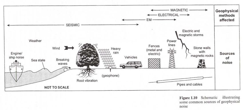
UD1
CONCETTI DI BASE
SENSIBILITA’ / SENSITIVITA’
“Two different materials can be discriminate only if the
applied geophysical method is SENSITIVE to a physical
parameter DIFFERENT for the two materials” SEG dictionary
Contrasto (Geo)Fisico “Anomalia”
APPLICABILITA’ dei metodi
E’ FUNZIONE DEGLI OBIETTIVI DI INDAGINE!
Resistivity range Ωm
Ad esempio: resisitività
Metodi sismici
LAEG A.A. 2020-2021 4
UD1
CONCETTI DI BASE
Risoluzione
Massimo livello di dettaglio
raggiungibile
o, meglio, la minima
distanza che consente di
descrivere come “separati”
due oggetti distinti
VERTICALE/ORIZZONTALE
Unità idrogeologiche
superficiali 50m
Sørensen, 2004 Telford, 1989
LAEG A.A. 2020-2021 5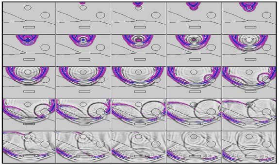
UD1
                  CONCETTI DI BASE
 Risoluzione

                                                          Thickness (m)
                                                    0

Reale geologia                                      50

                                                    100
                                                     0

                                                                 Time (ms)
Sezione sismica
                                                     50

A riflessione
                                                    100

(sintetica)
                                                    150

  Normalmente (ma non sempre) i metodi geofisici
      altamente risolutivi sono i piu’ costosi
    Quindi è indispensabile un compromesso tra
     COSTI GLOBALI e RISULTATI ATTESI
      Un problema cruciale è che ogni metodo
inappropriato (anche se a basso costo) non fornisce
  informazioni utili e rappresenta quindi un costo
               inutile e senza senso. LAEG A.A. 2020-2021                    6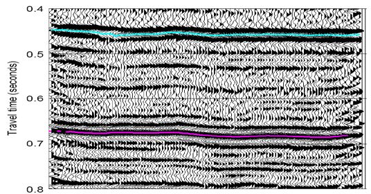
UD1
CONCETTI DI BASE
Sensibilità, Risoluzione, applicabilità
0km
Plio-Quaternary
0m
Tertiary
Mesozoic
2m
Batolite
GPR (electromagnetic waves)
Ultra High Resolution Section (150-350MHz)
MAX Penetration Depth 2-20m
Resolution 0.1-0.5m
PER TUTTI I METODI GEOFISICI Lower Crust
LA RISOLUZIONE DIMINUISCE 32Km Moho
CON LA PROFONDITA’
Mantle
Non è possibile ottenere un alto
grado di dettaglio per profondità Deep reflection Seismic (elastic waves)
crescenti Definizione dei Low Resolution Section (5-50Hz)
MAX Penetration Depth 40Km
TARGET/OBIETTIVI Resolution 10-100m
APPLICABILITA’ LAEG A.A. 2020-2021 7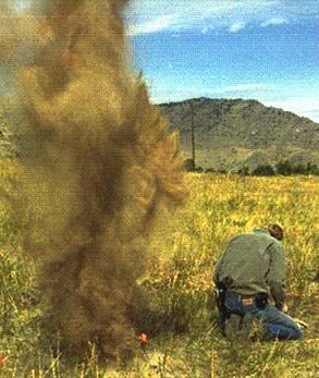
UD1
CONCETTI DI BASE
Applicabilità
L’APPLICABILITA’ dipende quindi dalle POTENZIALITA’ di una
metodologia geofisica di INDIVIDUARE E CARATTERIZZARE
uno o piu’ OBITTIVI DI INDAGINE (Target)
quindi f(parametri fisici) dei materiali
MA NON SOLO!
Dipende anche da:
1. DIMENSIONI E PROFONDITA’ DEI TARGET
2. PARAMETRI DI ACQUISIZIONE UTILIZZATI (geometrici,
campionamento, frequenze, energia,…)
3. RUMORI (coerenti e casuali) Rapporto S/N
4. CONDIZIONI LOGISTICHE (accessibilità, tipo di copertura,
presenza di vincoli,…)
5. Tipologia di rilievo (geometria, copertura, 2D, 2.5D, 3D, 4D,…)
6. COSTI/RISULTATI ATTESI
7. Tipo e modalità di ELABORAZIONE APPLICATE
8. DISPONIBILITA’ di dati pregressi LAEG A.A. 2020-2021 8
UD1
CONCETTI DI BASE
Applicabilità
Puo’ quindi essere molto difficile STIMARE l’applicabilità ed i
risultati attesi con l’utilizzo di una particolare metodologia:
MODELLAZIONE Preliminare (se sono noti almeno
approssimativamente alcuni dei parametri fisici in gioco)
FIELD TEST preliminari per la valutazione dei risultati e la
scelta dei parametri e delle tecniche ottimali di acquisizione
E’ pericoloso procedere utilizzando solo schemi STANDARD
Risultati altamente SITE-DEPENDENT
Ad es. il NUMERO DI MISURE NECESSARIE puo’ condizionare
pesantemente i risultati e dipende da molti fattori, quali:
• Rumori ambientali/di fondo affidabilità delle misure
• Grado di dettaglio necessario funzione della “complessità” del
sito approssimazioni 1D, 2D, 3D, omogeneità,
isotropia, …) e degli obiettivi di indagine (dimensioni,
profondità, contrasto, forma, distribuzione geometrica,
sovrapposizione,…)
• Metodologia di indagine prescelta
LAEG A.A. 2020-2021 9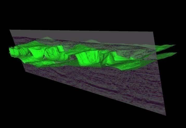
UD1
METODI ATTIVI e PASSIVI
Geophysical methods can be classified into one of two types: Passive and Active
Passive geophysical methods Measurements of naturally occurring fields or properties of
the earth Spatial variations of these fields or properties and attempt to infer something
about the subsurface material distibution (geology).
Gravitational field, Magnetic field, Electric field (Self Potential), Electromagnetic field
(Magneto Telluric), Earthquakes/natural ground movement,Temperature/Heat flow, Pressure,
Radiometric decay products, ...
Seismic Survey with explosive
Gravity Survey
Active geophysical methods a “perturbation/signal” is injected into the earth to
measure how the subsurface responds to this signal Extract subsurface physical
parameter/imaging.
Electrical current Many electrical methods (ERT, VES, IP, ...);Electromagnetic
currents/waves Ground Penetrating Radar, Several Inductive methods (FDEM,
TDEM,...); Groung displacement Seismic methods (reflection, Refraction, MASW,...);
Active radiometric sources, ...
LAEG A.A. 2020-2021 10UD1
METODI ATTIVI e PASSIVI: vantaggi e svantaggi
Active Passive
+ - + -
Complex Field equipment Surveyor need only Less control of noise
Better control of noise
Both “Sources” and record a naturally because source of the
sources through control
“Receivers” must be occurring field no signal is out of the hands
of injected signal
supplied source need of the surveyor.
Field operations and
Results in term of
Active experiments logistics are generally Field operations are
“anomalous geological
usually provide better more complex time generally very time
contributions” difficult
depth control over source consuming more efficient wide areas
(impossible) identification
of anomalous signal expensive than passive cost-efficiency
of the source
experiments
Survey design flexibility Only few (standard) field
Greater survey design
in customizing surveys for Only few (standard) field procedures are generally
costs and potentially
particular problems. procedures are generally used. This limits the
leads to increased
Many possible used. Relatively easy amount of customisation
probability of field
Source/receivers survey design that can be done for
mishaps
geometries specific problems.
The data sets collected
The large quantity of Limited datasets (not
Large quantities of data are (usually) smaller than
data obtained in many always) can be
can be acquired to those collected in active
active experiments can accomplished with modest
interpret subtle details experiments and do not
become overwhelming to computational
of the earth's subsurface allow for as detailed an
process and interpret requirements
interpretation.
LAEG A.A. 2020-2021 11UD1
METODI ATTIVI e PASSIVI: vantaggi e svantaggi
Active Passive
+ - + -
Sometimes invasive
methods: sources are Not invasive systems:
required (explosives, high only sensors are required
voltages)
Source type/energy can
be tailored on the survey
No source control time
objectives. It can be
drifting, changes,
perfectly repetitive with
obstacles.
precise time and position
knowledge
Un altro importante criterio di classificazione
si basa sulla distinzione tra
METODI “di potenziale” e “wave field”
LAEG A.A. 2020-2021 12UD1
“Potential field” and “wave field” methods
Potential methods measure potential fields
NOTE: A force fields can be described as a potential field if the field is conservative (work path
independent). Conservative forces can be represented mathematically by simple scalar expressions
known as POTENTIALS
The Potential fields used for geophysical exploration are:
1) Gravitational 2) Magnetic 3) Electric
To recover the PHYSICAL PARAMETER DISTRIBUTION the dataset must
be INVERTED
NON-LINEAR PROBLEM i.e. no by univocal correspondence between:
MEASURED FIELD PROPERTIES and PHYSICAL PARAMETERS (MODELS)
IN THEORY INFINITE MODELS COULD MATCH A MEASURED FIELD
DISTIBUTION
TYPICAL UNDERCONSTRAINED PROBLEM
Additional information are required (direct data, other
geophysical data, ...) LAEG A.A. 2020-2021 13UD1
“Potential field” method: conceptual EXAMPLES
Measured gravity field Mass/density distribution
Measured gravity field Mass/density MODEL
soil
ore
Regional/global
Local effects effects
local anomalies large scale
anomalies
Data INTERPRETATION
The direct problem is to compute The inverse problem is to determine
gravity potential and force when the the density using the force (the
density is known. potential) on a given surface.
FORWARD modelling INVERSE modelling
LAEG A.A. 2020-2021 14UD1
“Potential field” and “wave field” methods
Wave field methods based on the propagation of a perturbation
(wave) within the earth
The most common are Seismic (elastic waves) and
Electromagnetic waves
The perturbation (or signal) travels into the subsurface, is
REFLECTED/REFRACTED/SCATTERED/BACKSCATTERED/CON
VERTED and therefore can be recorded at the surface (or into a
borehole) by one or more sensors as a function of the time
(typically the time zero is the energizing instant)
No data inversion is required (but it is possible) direct
IMAGING of the subsurface
SOURCE Record: reflection seismic section
Distance
Distance
LAEG A.A. 2020-2021 15UD1
“Potential field” and “wave field” methods
Field experiment recorded data (with interpretation)
To obtain a real subsurface IMAGING a complex processing is
required, but usually final results are very close to the reality
Paleo Channel Faults
Original data
Salt Processed data
Diapir (coherency timeslice)
From: Bahorich et al., 1995
LAEG A.A. 2020-2021 16UD1
“Potential field” and “wave field” methods
Processing 1D, 2D, 3D
Seismic section after
preliminary processing (Stack)
Depth [m]
Depth [m]
Seismic section after Depth
migration
LAEG A.A. 2020-2021 17Pianificazione di un rilievo UD1
Bisogna tenere conto di molti fattori, spesso contrastanti:
• Obiettivi dell’indagine
• Sensibilità, Risoluzione, Applicabilità
• Costi/risultati
• Tempi
• Vincoli logistici
• Disponibilità e tipologia delle informazioni pregresse
• Disponibilità della strumentazione
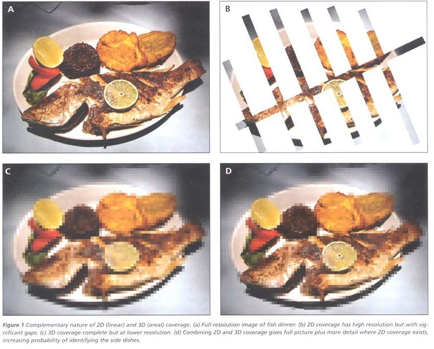
Quantità e modalità delle
misure necessarie
Campionamento spaziale
LAEG A.A. 2020-2021 18Pianificazione di un rilievo UD1
Quantità e modalità delle
misure necessarie
1D, 2D, 3D, 4D,…
LAEG A.A. 2020-2021 19Pianificazione di un rilievo UD1
Quantità e modalità delle
misure necessarie
1D, 2D, 3D, 4D,… La scelta è funzione degli
OBIETTIVI DELL’INDAGINE
Vestrum & Gittins 2008
LAEG A.A. 2020-2021 20Pianificazione di un rilievo UD1
Quantità e modalità delle
misure necessarie
Reynolds, 1997
Livelli di rumori S/N ratio
LAEG A.A. 2020-2021 21UD1
E’ molto importante INTEGRARE metodi geofisici diversi che
analizzano vari parametri fisici e VERIFICARE/TARARE i
risultati anche con metodi diretti
LAEG A.A. 2020-2021 22UD1
TUTTO E’ CHIARO?
LAEG A.A. 2020-2021 23Puoi anche leggere