Federico II Open Access University Press
←
→
Trascrizione del contenuto della pagina
Se il tuo browser non visualizza correttamente la pagina, ti preghiamo di leggere il contenuto della pagina quaggiù
Dicea
                                           UniNa

Federico II Open Access University Press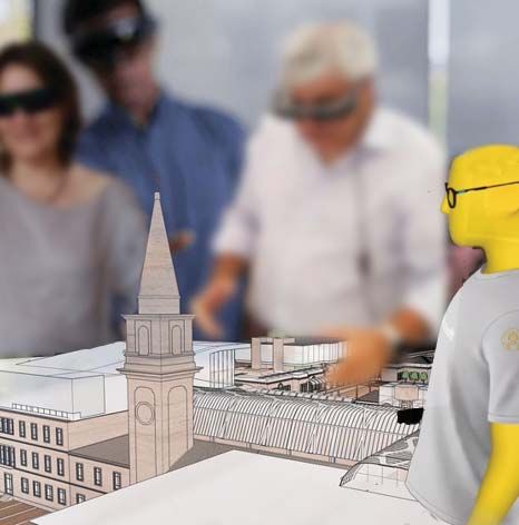
Università degli Studi di Napoli Federico II
        Scuola Politecnica e delle Scienze di Base

Smart City, Urban Planning for a Sustainable Future

                            4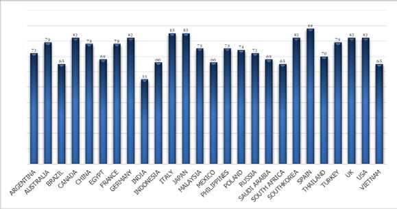
Environmental and territorial modelling
       for planning and design

        Antonio Leone   Carmela Gargiulo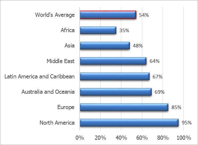
Environmental and territorial modelling for planning and design editors
 Antonio Leone, Carmela Gargiulo - Napoli: FedOAPress. 2018. - (Smart
 City, Urban Planning for a Sustainable Future. 4).

 Web link:
 http://www.fedoabooks.unina.it

 ISBN: 978-88-6887-048-5
 DOI: 10.6093/978-88-6887-048-5

Editor
Rocco Papa, University of Naples Federico II, Italy

Editorial Advisory Board
Mir Ali, University of Illinois, USA - Luca Bertolini, Universiteit van Amsterdam, Paesi Bassi - Luuk
Boelens, Ghent University, Belgium - Dino Borri, Politecnico di Bari, Italia - Enrique Calderon,
Universidad Politécnica de Madrid, Spagna - Roberto Camagni, Politecnico di Milano, Italia - Derrick
De Kerckhove, University of Toronto, Canada - Mark Deakin, Edinburgh Napier University, Scotland
- Aharon Kellerman, University of Haifa, Israel - Nicos Komninos, Aristotle University of
Thessaloniki, Grecia - David Matthew Levinson, University of Sydney, Australia - Paolo Malanima,
Magna Græcia University of Catanzaro, Italy - Agostino Nuzzolo, Università degli Studi di Roma Tor
Vergata, Italia - Rocco Papa, Università degli Studi di Napoli Federico II, Italia - Serge Salat, Urban
Morphology and Complex Systems Institute, France - Mattheos Santamouris, National Kapodistrian
University of Athens, Greece - Ali Soltani, Shiraz University, Iran

Selection and double blind review under responsibility of Conference Committee

© 2018 FedOAPress - Federico II Open Access University Press
Università degli Studi di Napoli Federico II
Centro di Ateneo per le Biblioteche “Roberto Pettorino”
Piazza Bellini 59-60 - 80138 Napoli, Italy
http://www.fedoapress.unina.it

Published in Italy
Gli E-Book di FedOAPress sono pubblicati con licenza
Creative Commons Attribution 4.0 International

Cover and graphic project: TeMALAB

This book collects the papers presented at the 10th
                                                 International Conference INPUT 2018 which will take place in
                                                 Viterbo from 5th to 8th September. The Conferences pursues
                                                 multiple objectives with a holistic, boundary-less character to
                                                 face the complexity of today socio-ecological systems following
                                                 a systemic approach aimed to problem solving. In particular, the
                                                 Conference aims to present the state of art of modelling
                                                 approaches employed in urban and territorial planning in
                                                 national and international contexts.

S C I E NTIFI C C OM M I TEE                                   C ONFE RE NC E C OM M I TEE

Ivan Blecic - Università di Cagliari                           Ivan Blecic - Università di Cagliari
Dino Borri - Politecnico di Bari                               Marta Bottero - Politecnico di Torino
Marta Bottero - Politecnico di Torino                          Domenico Camarda - Politecnico di Bari
Domenico Camarda - Politecnico di Bari                         Michele Campagna - Università di Cagliari
Michele Campagna - Università di Cagliari                      Arnaldo Cecchini - Università degli Studi di Sassari
Arnaldo Cecchini - Università degli Studi di Sassari           Donatella Cialdea - Università del Molise
Donatella Cialdea - Università del Molise                      Valerio Cutini - Università di Pisa
Giovanni Colombo - ISMB Istituto Superiore Mario Boella        Andrea De Montis - Università degli Studi di Sassari
Valerio Cutini - Università di Pisa                            Romano Fistola - Università degli Studi del Sannio
Andrea De Montis - Università degli Studi di Sassari           Paolo La Greca - University of Catania
Giovanna Fancello - Dauphine University (Paris)                Daniele La Rosa - University of Catania
Romano Fistola - Università degli Studi del Sannio             Antonio Leone - Tuscia University
Carmela Gargiulo - Università di Napoli “Federico II”          Sara Levi Sacerdotti - SITI Istituto Superiore sui Sistemi
Davide Geneletti - University of Trento                        Territoriali per l'Innovazione
Roberto Gerundo - Università degli Studi di Salerno            Stefania Mauro - SITI Istituto Superiore sui Sistemi
Federica Gobattoni - Tuscia University                         Territoriali per l'Innovazione
Paolo La Greca - University of Catania                         Beniamino Murgante - University of Basilicata
Daniele La Rosa - University of Catania                        Raffaele Pelorosso - Tuscia University
Giuseppe Las Casas - University of Basilicata                  Alessandro Plaisant - Università degli Studi di Sassari
Antonio Leone - Tuscia University                              Corrado Zoppi - Università di Cagliari
Sara Levi Sacerdotti - SITI Istituto Superiore sui Sistemi
Territoriali per l'Innovazione
Giampiero Lombardini - Università degli Studi di Genova
Stefania Mauro - SITI Istituto Superiore sui Sistemi           O RGANI Z I NG C OM MI TE E
Territoriali per l'Innovazione
Giulio Mondini - Politecnico di Torino
                                                               Antonio Leone - Tuscia University
Beniamino Murgante - University of Basilicata
                                                               Raffaele Pelorosso - Tuscia University
Silvie Occelli - IRES Piemonte
                                                               Federica Gobattoni - Tuscia University
Rocco Papa - Università di Napoli “Federico II”                Maria Nicolina Ripa - Tuscia University
Raffaele Pelorosso - Tuscia University                         Fabio Recanatesi - Tuscia University
Alessandro Plaisant - Università degli Studi di Sassari
                                                               Beniamino Murgante - University of Basilicata
Bernardino Romano - Università degli Studi dell'Aquila
                                                               Romano Fistola - Università degli Studi del Sannio
Francesco Scorza - University of Basilicata
                                                               Andrea De Montis - Università degli Studi di Sassari
Maurizio Tira - University of Brescia
                                                               Mauro Patano - Politecnico di Bari
Angioletta Voghera - Politecnico di Torino
Corrado Zoppi - Università di Cagliari
This book is the latest scientific contribution of the “Smart City, Urban Planning for a Sustainable Future” Book Series, dedicated to the collection of research e-books, published by FedOAPress - Federico II Open Access University Press. The volume contains the scientific contributions presented at the INPUT 2018 Conference and evaluated with a double peer review process by the Scientific Committee of the Conference. In detail, this publication, including 63 papers grouped in 11 sessions, for a total of 704 pages, has been edited by some members of the Editorial Staff of “TeMA Journal”, here listed in alphabetical order: - Rosaria Battarra; - Gerardo Carpentieri; - Federica Gaglione; - Rosa Anna La Rocca; - Rosa Morosini; - Maria Rosa Tremiterra. The most heartfelt thanks go to these young and more experienced colleagues for the hard work done in these months. A final word of thanks goes to Professor Roberto Delle Donne, Director of the CAB - Center for Libraries "Roberto Pettorino" of the University of Naples Federico II, for his active availability and the constant support also shown in this last publication. Rocco Papa Editor of the Smart City, Urban Planning for a Sustainable Future” Book Series Published by FedOAPress - Federico II Open Access University Press
Table of contents

Table of contents

Introduction                                                                                       13

Session 1 - Territorial modelling: state-of-art and future development

An integrated evaluation model for shaping future resilient scenarios in multi-pole territorial    17
systems
Vanessa Assumma, Marta Bottero, Roberto Monaco, Ana Jacinta Soares
Features of agents’ spatial knowledge in planning open spaces. A pilot study                       25
Domenico Camarda, Giulia Mastrodonato
Agent-based modelling and geographic information system for evaluation                             35
of eco-district's scenarios
Caterina Caprioli, Marta Bottero
Land development support in marginal areas. An opportunity of environmental                        47
quality implementation
Elena Cervelli, Stefania Pindozzi, Donatella Cialdea
Landscape urbanism’s interpretative models. A new vision for the Tiber river                       57
Donatella Cialdea, Chiara Pompei
The land of the border                                                                             69
Silvia Dalzero
The territorial frames. A new integration model for local development                              79
Donato Di Ludovico, Federico d' Ascanio
Supporting retail planning with territorial models. Approaches, innovations and opportunities      87
Giorgio Limonta, Mario Paris
Geosimulation methods for settlement morphologies analysis and                                    105
territorial development cycles
Giampiero Lombardini

Session: 2 - Environment, planning and design: the role of modelling

Climate change and coastal cities. A methodology for facing coastal flooding                      115
Carmela Gargiulo, Rosaria Battarra, Maria Rosa Tremiterra
Ecosystem Services for spatial planning. A remote-sensing-based mapping approach                  127
Davide Longato, Denis Maragno, Francesco Musco, Elena Gissi
Integrating participatory modelling in risk management                                            139
Giulia Motta Zanin, Stefania Santoro
Surface temperature variation and urban heat island intensity in Antofagasta, Chile               147
Massimo Palme, Francisco Flores, Leonardo Romero
The places and times in risk management. The case of the school system                            159
Francesca Pirlone, Ilenia Spadaro
ontents

Distributed delay models. A proposal of application in urban context                              169
to forecast pest insects’ life cycle
Luca Rossini, Maurizio Severini, Mario Contarini, Stefano Speranza

Session 3 - Rural landscapes and well-being: towards a policy-making
perspective

Spatial relations in the benefits from ecosystem services. The case study of Bratsigovo           179
municipality
Angel Petrov Burov
Historical land use change and landscape pattern evolution study                                  189
Elena Cervelli, Ester Scotto di Perta, Annalisa di Martino, Salvatore Faugno, Stefania Pindozzi
Landscape defragmentation policy and planning. An assessment of strengths and                     199
weaknesses
Andrea De Montis, Antonio Ledda, Vittorio Serra
Governance and adaptation to climate change. An investigation in Sardinia                         207
Andrea De Montis, Antonio Ledda, Elisabetta Anna Di Cesare, Daniele Trogu, Michele
Campagna, Gianluca Cocco, Giovanni Satta
Integrating climate change adaptation into SEA. An assessment for Sardinia, Italy                 215
Andrea De Montis, Elisabetta Anna Di Cesare, Antonio Ledda, Daniele Trogu, Michele
Campagna, Gianluca Cocco, Giovanni Satta, Agnese Marcus
Modis data for detection of landscape changes by oil palm plantations in Borneo                   223
Samuele De Petris, Piero Boccardo, Barbara Drusi, Enrico Borgogno Mondino
Water technologies and rural landscapes in the Apulia region. Multi-sectoral and multi-           231
functional approaches to analysis and planning
Laura Grassini
Natural rural landscape perception and restorativeness                                            243
Giulio Senes, Luca Pernechele, Rita Berto, Natalia Fumagalli, Giuseppe Barbiero
Evaluating ecological connectivity in cultivated and urbanized areas at landscape scale.          257
A case study in the North-East plain area of Italy
Maurizia Sigura, Marco Vizzari, Francesco Boscutti

Session 4 - Smart planning

Analysis of zoning plan changes in an urban regeneration area                                     269
Burcu Aslan, Cankut Dağdal Ince
Italian metropolitan cities. A quantitative analysis aimed at the implementation of               281
governance and innovation policies
Giuseppe Mazzeo
Classifying railway station catchment areas. An application of node-place model to the            299
Campania region
Rocco Papa, Gerardo Carpentieri
Contents

Session 5 - Maintenance, upgrading and innovation in cultural heritage

Social construction of space in heritage conservation. Geo-mining Park in Sardinia              323
Nađa Beretić, Arnaldo Cecchini, Zoran Đukanović
Enhance the historical city with new technologies                                               331
Francesco Botticini, Michele Pezzagno, Michela Tiboni
The chartreuse in Calci. Application of a multi criteria decision making method (MCDM) to its   341
functional recovery
Ewa Karwacka, Luisa Santini, Denise Italia
Spatial data infrastructure in historical contexts. The case study of Matera                    357
Piergiuseppe Pontrandolfi, Antonello Azzato
On restoring and reviving lost religious buildings. Multi criteria analysis techniques to       369
address an increasingly underused patrimony
Elisabetta Pozzobon, Luisa Santini, Alessandro Santucci

Session 6 - Urban and environmental planners: who is the client? The
planners jobs in a new millennium

Gap Reduce. A research & development project aiming at developing a tool for promoting          383
quality of urban life of people with autism spectrum disorder
Tanja Congiu, Francesco Lubrano, Luca Pilosu, Pietro Ruiu, Valentina Talu, Giulia Tola,
Giuseppe Andrea Trunfio
Biourbanism. The role of environmental systems in urban regeneration processes                  393
Mauro Francini, Lucia Chieffallo, Annunziata Palermo, Maria Francesca Viapiana
Environmental criteria. Consistency between the Minimum Environmental Criteria and the          401
Itaca Protocol criteria concerning the quality of the intervention site
Mauro Francini, Giusi Mercurio, Annunziata Palermo, Maria Francesca Viapiana
G3w-suite, publishing and managing cartographic Qgis projects on the web. The use in            409
“Foreste Casentinesi, Monte Falterona e Campigna” National Park
Walter Lorenzetti, Francesco Boccacci, Leonardo Lami, Davide Alberti,
Matteo Ruocco

Session 7 - Big data and data mining

Tangible and intangible aspects in the promotion and fruition of the UNESCO sites. A case of    417
sustainable innovation
Marichela Sepe

Session 8 - ICT & models: planning for communities

Toward clarification of meanings via ontological analysis method in environmental planning      427
processes and actions
Domenico Camarda, Maria Rosaria Stifano Melone, Stefano Borgo, Dino Borri
Contents

Implementing GIS technology. A spatial decision support system tool to study the impacts of   437
land uses
Tullia Valeria Di Giacomo
Augmenting the Smart City. A "new view" for the urban planning                                449
Romano Fistola, Rosa Anna La Rocca
Regenerate, retrain, reuse. A GIS based on spatial multi criteria analysis for the            461
redevelopment of abandoned military areas in Pisa
Anna Maria Miracco, Luisa Santini, Alessandro Santucci
Opportunities for the use of collaborative 3D mapping in post-disaster situations             475
Camilla Pezzica, Valerio Cutini, Clarice Bleil de Souza

Special session 1: Did we learn lessons? Following the paths of Giovanni
Rabino

Models at the time of weak planning. Their role, if any                                       483
Valerio Cutini
Informal settlements, complexity and urban models. Is there any order in autopoietic urban    491
systems?
Valerio Cutini, Valerio Di nto
From the rules to the models and vice-versa for a new planning rationality                    499
Giuseppe B. Las Casas, Beniamino Murgante, Francesco Scorza
A meta-model of regional transportation planning: the case of Piedmont                        509
Sylvie Occelli

Special session 2: Ecosystem-based and performance-based approaches
for spatial planning

Ecosystem services and ecological networks. A case study from Flanders                        531
Ignazio Cannas, Daniela Ruggeri
Resilient criteria for strategic road network                                                 543
Mauro Francini, Sara Gaudio, Annunziata Palermo, Maria Francesca Viapiana
Inclusion of ecosystem-based approaches in the regulations of marine protected areas. An      551
experimental procedure developed in Sardinia. Part 1
Federica Isola, Francesca Leccis
Inclusion of ecosystem-based approaches in the regulations of marine protected areas. An      561
experimental procedure developed in Sardinia. Part 2
Maddalena Floris, Salvatore Pinna
Spreading green infrastructure-related benefits a study concerning Sardinia, Italy            569
Sabrina Lai, Federica Leone, Corrado Zoppi
What planning for facing global challenges? approaches, policies, strategies, tools,          577
ongoing experiences in urban areas
Gabriella Pultrone
Ecology-based planning. Italian and French experimentations                                   589
Angioletta Voghera, Benedetta Giudice
Contents

Special session 3: Geodesign

The geological workshop of geodesign for landscape planning                                   595
Pedro Benedito Casagrande, Ana Clara Mourão Moura
A hybrid decision-making process for wastescapes remediation. Geodesign, LCA,                 603
urban living lab interplay
Maria Cerreta, Pasquale Inglese, Chiara Mazzarella
Towards a novel approach to geodesign analytics                                               611
Chiara Cocco, Michele Campagna
Facing urban regeneration issues through geodesign approach. The case of Gravina              619
in Puglia
Pietro Fiore, Angela Padula, Angela Pilogallo, Francesco Scorza
A geodesign project on Post-Earthquake rehabilitation. Co-designing a strategy for Norcia     633
Francesco Fonzino, Emil Lanfranchi
Complementary web-based geoinformation technology to geodesign practices. Strategic           643
decision-making stages of co-creation in territorial planning
Ana Clara Mourão Moura, Simona Tondelli, Aurelio Muzzarelli
Collaborative approach in strategic development planning for small municipalities. Applying   665
geodesign methodology and tools for a new municipal strategy
in Scanzano Jonico
Angela Padula, Pietro Fiore, Angela Pilogallo, Francesco Scorza
The application of geodesign in a Brazilian illegal settlement. Participatory planning        673
in Dandara occupation case study
Susanna Patata, Priscila Lisboa De Paula, Ana Clara Mourão Moura
From the logic of desktop to web services applications in GIS. The construction of basic      687
evaluation maps to support urban planning and co-design.
Nicole Andrade Rocha, Ana Clara Mourão Moura, Hrishikesh Ballal, Christian Rezende,
Markus Neteler
Introduction

INTRODUCTION
Between 5th and 8th September 2018 the tenth edition of the INPUT conference took place in Viterbo,
guests of the beautiful setting of the University of Tuscia and its DAFNE Department.
INPUT is managed by an informal group of Italian academic researchers working in many fields related to
the exploitation of informatics in planning.
This Tenth Edition pursed multiple objectives with a holistic, boundary-less character, to face the complexity
of today socio-ecological systems following a systemic approach aimed to problem solving. In particular, the
Conference will aim to present the state of art of modeling approaches employed in urban and territorial
planning in national and international contexts.
Moreover, the conference has hosted a Geodesign workshop, by Carl Steinitz (Harvard Graduate School of
Design) and Hrishi Ballal (on skype), Tess Canfield, Michele Campagna.
Finally, on the last day of the conference, took place the QGIS hackfest, in which over 20 free software
developers from all over Italy discussed the latest news and updates from the QGIS network.
The acronym INPUT was born as INformatics for Urban and Regional Planning. In the transition to graphics,
unintentionally, the first term was transformed into “Innovation”, with a fine example of serendipity, in
which a small mistake turns into something new and intriguing. The opportunity is taken to propose to the
organizers and the scientific committee of the next appointment to formalize this change of the acronym.
This 10th edition was focused on Environmental and Territorial Modeling for planning and design. It has
been considered a fundamental theme, especially in relation to the issue of environmental sustainability,
which requires a rigorous and in-depth analysis of processes, a theme which can be satisfied by the
territorial information systems and, above all, by modeling simulation of processes.
In this topic, models are useful with the managerial approach, to highlight the many aspects of complex city
and landscape systems. In consequence, their use must be deeply critical, not for rigid forecasts, but as an
aid to the management decisions of complex systems.

                                                       15
AUGMENTING THE SMART CITY
A “NEW VIEW” FOR THE URBAN PLANNING
ROMANO FISTOLAa, ROSA ANNA LA ROCCAb
a
Department of Engineering,
University of Sannio
e-mail: romano.fistola@unisannio.it
URL: https://www.ding.unisannio.it/
b
Department of Civil, Architectural and
Environmental Engineering,
University of Naples Federico II
e-mail: larocca@unina.it
URL: http://dicea.unina.it/
How to cite item in APA format:
Fistola, R., & La Rocca, R.A. (2018). Augmenting the Smart City. A “new view” for the urban planning.
In A. Leone & C. Gargiulo (Eds.), Environmental and territorial modelling for planning and design.
(pp. 449-460
52 - 55). Naples: FedOAPress. ISBN: 978-88-6887-048-5, doi: 10.6093/978-88-6887-048-5
ABSTRACT
In recent years, Augmented Reality has gained interest both for being a technology that
offers many possibilities of interaction with mobile devices (smartphone and tablet) and for its
potentialities of being used in outside contexts. The recent transition of Augmented Reality from
the virtual context of the Video Games -within an indoor ambiance- to the real urban space
-within an outside ambiance- is providing new perspectives for urban planning processes, as a
result. Referring to this transition, the paper tries to investigate the possibilities of proposing
a new view for the urban planning process taking into account the potentialities of the recent
applications of the Augmented Reality. At the same time, the paper wonders on the possibility
of new perspectives that the Augmented Reality can offer to the research in the sector of the
town planning. Using a methodology based on a systemic approach, the paper intends to
underline the relations existing between urban subsystems and the use of technology. In these
relations, the social subsystem plays a central role, as its components (people living and using
the city) can improve the urban smartness by the adoption of responsible and aware behaviors.
AR applications in the field of the game (e.g. the phenomenon of PokemonGo) has shown how
people are willing to be involved in new ways of fruition of urban spaces as long as they can
use their mobile devices and they can share their own experiences on the social networks. This
attitude can be properly taken into account within the process of urban governance both to
improve the participative procedures and to explore new paths for the aware use of technologies.
These innovative research dimensions should be explored carefully and quickly, considering the
possible contribution of these values to the urban smartness.
KEYWORDS
Urban Smartness; City as a complex system; Augmented Reality; Smart and Resilient CityR. Fistola, R.A. La Rocca
1 INTRODUCTION: THE CONCEPT OF THE SMART CITY
In the last few years, the concept of the Smart City has become particularly prominent within scientific
debate, representing an opportunity to renew the way of thinking about cities and their social communities.
Early reflections, researchs and projects on this subject seem to converge towards the idea that an urban
smart development is the inevitable outcome of the infrastructural facilities (physical capital) and their
continuous innovation, but it also depends on the quality of the human, social and natural capital, intended
as strategic factors of development. In this sense, a smart city is, above all, a city capable of both meeting
the needs of its citizens and respecting environmental rules. The challenge, thus, is to make the city most
responsive to the needs of its users (residents) in terms of better quality of services, reduction of
environmental impacts (polluting emissions), and decrease in energy consumption, by using innovative
technologies (ICTs) (Caragliu et al., 2011).
From a town planning point of view, this does not seem very different from the visions that some scholars
(Cairncross, 1997; Mitchell, 1996) had in the last century about the change in the use of the city due to the
spread of new technologies. What characterized this vision was probably the collateral role of the new
technologies in the development of urban activities at the economic, social and physical levels. More
recently, the theme concerning the role of technology is still being investigated, focusing on the possibility of
re-defining the urban functional system using new technologies (Aurigi & De Cindio, 2008; Fistola & La
Rocca 2001; Willis, 2007). Up to now, and especially as it concerns the Italian situation, the study of the
relations between new technologies and the city has been neglected and probably considered as unrelated
to the needs of urban planning. At present, instead, technologies are assuming a significant role, and a
renewal of the methods and tools used in approaching the city is required.
The definition of a smart city, thus, can assume different aspects, but the real issue seems to be the
informed use of technologies to shift the urban system into a smart state. Augmented Reality (AR) can boost
this transition, enhancing the dimensions of the real urban system and involving the urban subsystems: the
socio-anthropic subsystem, as it allows citizens and city-users to have a new perception of the space; the
physical subsystem, as it acts on physical spaces, enriching the real scene with adjunctive information or
objects.
1.2 SMART CITY: IS THERE A SHARED DEFINITION?
The emergent “smart city” paradigm seems to highlight that the actual challenge consists in making cities
more efficient by means of innovating technologies (ICTs) capable of supporting the management,
monitoring and functioning of cities.
The Smart City approach, then, assumes that technology is part of the system and is not an additional
element in performing urban activities at different levels (economic, social and physical). In this vision, an
intelligent city is the one that, using technological innovation, spends less, and in the best way, without
reducing the quality of services for citizens and firms.
It is undeniable that ICTs play a central role in most of the Smart City projects developed over the last ten
years. Ratti (2012) points out their importance, preferring to refer to a senseable city, rather than a smart
one, that has citizens at the center of its interest (Ratti, 2012). In this sense, ICTs are the means to allow
citizens to act within the city.
450Augmenting the Smart City. A “new view” for the urban planning
Indeed, definitions of and approaches to the Smart City have not yet reached a common vision (Neirotti et
al., 2014) and the smart city seems to be more of an urban label than an alternative approach to urban
themes (Battarra et al., 2016; Holland, 2008). Papa et al. (2015) have investigated the lexical connection
between the words “smart” and “city,” underlining the disparities of complexity between them. The analysis,
considering roughly 156 smart city definitions, points out the lack of an organic vision of the urban system
as a whole that needs attention for the purpose of facing its present challenges (climate change, energy
conservation, CO2 emissions, etc.), rather than an excessive trust in technologies. Concerning the
requirement of a systemic vision, Giffinger et al. (2007) state that a smart city “is not used in a holistic way
(…) but for various aspects, which range from Smart City as an IT-district to a Smart City mainly referred at
the level of education of its inhabitants.”
Even though the combination of technological and social components is gaining increasing attention, two
different groups of interest can still now be identified in defining the smart city: the industrial and the
scientific. The first group has major interest in equipping the city with sensors; the second group should
point out methods and techniques able to support urban planning. Currently, contributions are mainly
oriented towards defining urban indicators to “measure” whether and how a city is “smart” (Cohen, 2012;
European House Ambrosetti, 2013; Testa, 2012; Wien University of Technology, 2012). Rarely do
contributions refer to a holistic vision of urban smartness; a vision applied per part (smart building, smart
district, smart street, smart infrastructure, etc.) seems to prevail. However, a holistic vision should allow for
positive effects through both technologies and social capital (Fistola, 2013; Papa et al., 2013; Ratti &
Townsend, 2011). The availability of a good level of human capital, in fact, is considered a factor of
competitiveness and territorial capacity of attraction. The active role of the human factor (the anthropic
system: the urban actors, residents, city users, tourists) is also becoming increasingly important, because it
can significantly affect the success/failure of a city.
In the context of these considerations, this paper examines the relationship between new technology and
the city, considering the dimension of games as a phenomenon that must be observed in order to allow
urban planners to face the radical changes occurring in present-day cities. The paper concludes by pointing
out the possibilities that the use of gamification and augmented reality can offer in improving the town
planning process for a real transition towards urban smartness.
2 METHOD AND MATERIAL: THE CITY AS A COMPLEX SYSTEM AND THE
TECHNOLOGICAL PUSH
Many scholars (Allen, 1997; Ashby, 1956; Batty, 2005; Bertuglia et al., 1987; Bertuglia & Vaio, 2011; Mc
Loughlin, 1969; Nijkamp & Reggiani, 1993; von Bertalanffy, 1968) have argued that the complexity of cities
allows us to consider the city as an open and complex geospatial system (Tab. 1).
The theoretical method of the complex systems could be applied in studying the evolution of the urban
systems.
Complexity represents the strategic factor able to ensure the evolution of the system itself. To reduce the
complexity of the system and to understand its mode of working, the urban system can be structured into
different subsystems that are connected to each other.
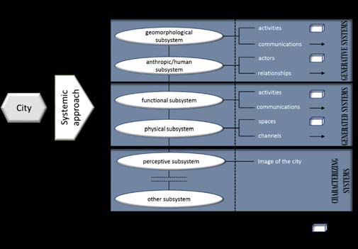
In particular, according to the aim of this study, we refer to the city as being constituted of five subsystems
that are composed of material and nonmaterial elements (Fig. 1). Subsystems are part of a whole that is the
urban system and they cannot be ultimately be separated.
451R. Fistola, R.A. La Rocca
City and the Complex System Properties
Multiplicity of elements composing the urban system
Complex systems are made of multiple elements, with different characteristics, functions and
structures. Within an urban system, there are material elements (buildings, squares, streets, etc.)
and nonmaterial elements (behaviors, economies, societies, etc.). The connections among these
elements can vary, differ and diverge: the quality and the types of connection compose a huge
and complex system known as the city.
Multilayer structure of the urban system
The vision of the city as being composed of multilayers has recently been affirmed. This vision
can be helpful in understanding the complexity of the urban system. The number of layers is
strictly connected to the level of complexity of a system: the more layers, the greater the
complexity. The layers include people, families, neighborhoods, streets, communities, and
districts, and they compose different subsystems that, in turn, are created by elements and
connections. A city can be intended as a complex n-dimensional system in which the n-layers-
subsystems represent its dimensions.
City as an open system
As a complex and dynamic system, a city is not in a state of equilibrium. According to non-
equilibrium self-organization theory, openness is a crucial condition for the system to evolve
towards a balanced state, even though it is a dynamic state of balance. The urban space is a
typical open system with a dissipative structure: it maintains connections with outside-producing
entropy in the form of waste and non-recoverable energy. Nevertheless, openness and
dissipation are basic conditions for complex systems.
Adaptivity and inner dynamics
People are the most important elements within the urban system. As individuals, they are active
and adaptive (CAS theory), and these characteristics are the main form of complexity. The
adaptiveness of an urban system causes inner changes affecting the population, economics and
social dynamics of the city.
Nonlinear interactions
Within the urban system, nonlinear interactions are generated among subsystems and inside of
them (i.e., the allometric relations between population and area). Nonlinearity is the main cause
of the complexity of the urban system.
Self-organization of the city
As a complex system, the city is characterized by self-organization, and its evolution does not
depend on external factors. The components of the system (the agents) transform themselves
according to simple and internal rules; lacking a global vision of the total evolution of the system,
nevertheless, they tend towards a state of equilibrium, moving from chaos to order.
Tab.1 Analogies between complex systems and the city
If the city is a complex system, it is not possible to plan the system’s future state, as it is complex, non-
linear, and stochastic. Therefore, the only way to lead the system towards a sustainable state, compatible
with the limited availability of resources, is to manage its evolution in an attempt to minimize the entropy
emitted during its evolutionary process (Fistola & La Rocca, 2013).
Among the urban subsystems, the social subsystem represents one of the generative systems of the city,
and its components are both the peoples living in and using the city (static component) and the connections
(dynamic component) among them.
2.1 THE SOCIAL SUBSYSTEM AND THE INNOVATION TECHNOLOGY
Focusing on the social subsystem, it is possible to observe that citizens’ behaviors have deeply changed
because of the technological revolution and the diffusion of the Internet. People are rapidly modifying their
habits by introducing the use of new technology into their daily lives. At the end of 2017, the Internet
penetration rate in Europe was about 85% of the total world population (Fig. 2).
452Augmenting the Smart City. A “new view” for the urban planning
Fig. 1 The urban system and the five sub-systems identified
Fig. 2 The Internet world penetration rate per regions calculated on a population of about 7 billion of people (source
www.internetworldstats.com, accessed in June 2018)
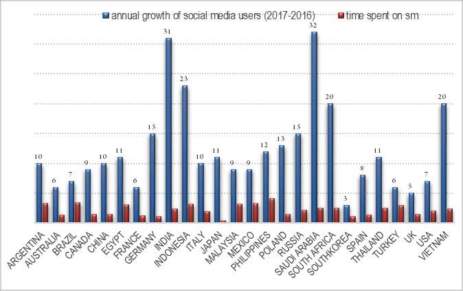
This means that, around the world, the number of connections to internet and the consequent consumption
of data are increasing at a rate double that of the birth rate (Fig. 3).
As a matter of fact, technological interaction has taken over a significant portion of the dynamic of human
relationships. An example can be the “Facebook effect” on our interpersonal relationships and the
importance in social implication assumed by the number of “likes” to gain a social assent (Reich et al.,
2018). It is also possible to state that technological revolution impacts each urban subsystem and especially
the social subsystem. Important is to manage the change instead of try to hinder it.
453R. Fistola, R.A. La Rocca
Fig. 3 Percentage of the growth of users of social media (Facebook, and others) and average of time spent per day (survey of users aged
16-64; source Digital in 2017 www.wearesocial.com, accessed in June 2018)
So far, games, software and apps have changed our lives deeply. This also depends on the level of attention
that we devote to the technological dimension through our personal digital devices. The technological
convergence that considers the smartphone as a tool useful for receiving, elaborating on and exchanging
data and information has determined the vital function of every personal device. Furthermore, the diffusion
of social networks has created a personal cyber dimension to which it is hard to renounce: nowadays, it is
tough to resist answering our mobile when we receive a message (SMS, WhatsApp, Instagram or other),
even in the most improbable situation. The use of the smartphone has been also considered as an addiction
(South University, 2013). Some scholars in psychology (Gibson 2011; Merlo 2007; Yadav & Yadav, 2016), in
fact, have observed certain problematic behaviors due to the excessive use of smartphones (absence of
perception of reality and surroundings, aversion to socialization, loss of face-to-face relationships). They
remark that the problem could become as serious as substance abuse, even though, obviously, the
consequences on health are deeply different. The cyberkrank (Spitzer, 2016), thus, also seems to have
infected people when they are in a group, at close range, and they cannot help but use their smartphones
rather than communicate with each other, driven by the need to be “connected.” At present, it is possible to
say that technology has a high level of attention in everybody’s life and that a significant portion of our daily
activities has changed due to the technological push.
2.2 VIRTUAL WORD AND AUGMENTED CITY
The extreme impact of technology on the social system is quite likely the growth of a parallel dimension to
which correspond the born of a new urban subsystem: the communicational one (Fistola, 2001).
From the first studies dealing with the urban transformation of the city, due to the Innovation
Communication Technology (ICT) at the end of the 90s with the seminal books by Steve Ghrahm in UK
(Graham & Marvin, 1996), William Mitchell in USA (Mitchell, 1996) and, before all, the researchers led by
Corrado Beguinot and his research group in Italy (Beguinot, 1989), we are now in a new phase of the
development process. In this step all the urban subsystems are affected by ICT and the urban system as a
whole evolves in time and space by generating an enormous quantity of data (big data) collected by artificial
and anthropic sensors.
454Augmenting the Smart City. A “new view” for the urban planning
Fig. 4 Percentage of mobile user penetration per country compared to national population, 2017 (source Digital in 2017
www.wearesocial.com, accessed in June 2018
At this time thanks to ICT everybody can participate in the development process of the city by writing a
piece of the urban open source code (Carta, 2018). In order to play this role urban actors, (the components
of socio-anthropic subsystem), can amplify theirs faculty to envisage a future dimension of the city by
"seeing", in the present spaces (physical subsystem), a new composition and a different allocation of urban
activities (functional subsystem). The augmented reality (AR) offers this possibility in a more efficient way of
the virtual reality (VR), that in the last decade has polarized the attention of scholars and company (for the
potential implementation for the videogames). The AR, instead of the VR, allows players to remain in the real
physical space and to have experiences that have nothing of either a physical or a real dimension. In other
words, the experience of the augmented reality (probably could be more correct to speak about: mixed reality)
allows persons in a real social system to interact in a real and physical, but “augmented,” city (Tab. 2).
Virtual Reality Augmented Reality
It replaces the real world It enlarges the scene, but the action occurs in the real world
It replaces the real scene through the building of a It enriches the real scene through information aimed at
virtual ambience solving complex tasks
The visual feedback is totally controlled by the digital The visual feedback is mixed (partly controlled and partly
system not)
Tab. 2 Main differences between Virtual Reality (VR) and Augmented Reality (AR)
By considering the worldwide (but ephemeral) success of the game called: “Pokemon GO” in 2016, in which
the players have to catch the Pokemons going around inside the city, forming hunters groups, and looking
for preys in a specific places of the urban context (like monuments, historical sites, and so on), the game,
thus, could be a new way to drive technology within the city and to affect the citizen’s ongoing life (Cecchini,
1993). Maybe, playing an urban game will become a way to make it possible, in the very near future, to
drive new behavior and define a new way of interacting with the urban subsystems. On this concept, Pablo
Chillon (2012) has argued: “the continuous dripping of game-like initiatives in urban contexts, and the
increased participation of full engaged multi-players can also help to create new opportunities for business
455R. Fistola, R.A. La Rocca
and green economies” (Chillon, 2012). The augmented city, thus, can represent a new development phase
of the smart city, in which technology allows the citizens to really see the modifications of their urban
system and offers them to be involved (meant as active participation) into the urban choices, by overcoming
difficulties due to the understanding of technical documents or project. The AR offers also new possibilities
in all the phases of town planning: for instance via telepresence, it is possible for planners, who are
physically locates in different places, to work together on their tridimensional project. In this regards, it is
possible to remark that the ICTs are radically changing the town planning process. This process have to
bicome a management process in which the development of the urban system can be monitored through the
appropriate use of the big data and the trend of the city can be foreseen by the correct application of the
new technological innovation such as AR, VR, 3D city modeling, BIM-GIS and so on.
3 RESULTS AND DISCUSSION: AR AND THE NEW URBAN PLANNING
Remaining within the boundaries of the real city, the AR affects all the urban subsystems: the social
subsystem, the functional subsystem and the physical subsystem. At the same time, the psycho-perceptive
subsystem (Lynch, 1960) is also involved, if we consider that the AR supports the real world with additional
information and does not build a new world avulsed from the real one (Webster et al., 1997). Some scholars
envisaged this capability to establish a correct balance between new technology and the management of city
transformations (Aurigi & De Cindio, 2008). The augmented reality will allow urban planners to consider the
opportunities and risks connected to urban transformation, permitting them to preserve fundamental
resources. By using augmented reality, it possible to redefines the urban space (in its physical and functional
organization). The gaming dimension could be significant in this sense. The new games that adopt AR allows
players to meet in the real space by demolishing the solipsistic attitude of the canonic videogame. There is
something that has been radically changed: the urban system has become the physical context of the game.
Considering Pokémon Go as a phenomenon that can synthetize the relationship between the use of new
technologies and the city, it is possible to point out some positive and negative issues affecting the urban
subsystems (Tab. 3).
Urban subsystems Positive effects Negative effects
Physical subsystem Outdoors vs Indoors The consideration of the city as a mere
Push to explore the city playground
New landmark locations The lack of attention to urban patterns
Functional Use of geospatial disciplines and Scarcity of planning the events to catch the
Subsystem innovative procedures to map the city monsters
Support for administrators in monitoring Personal security
city representation Illegal use of personal data
Improvement of urban points of interest, Capturing of personal data
including for the promotion of tourism to Careless behavior in regard to urban automotive
the city traffic
Monitoring of landmark locations Uncontrolled overcrowding
Updating of information about the state of
the city
Improvement of urban requalification
policies
Social-anthropic The elimination of “digital solitude” Resident acceptance
subsystem Push to meet people outdoors and create Personal security
communities Capturing of personal data
Social competition
Increase in aggressiveness
Tab. 3 Positive and negative effects affecting the urban subsystems
456Augmenting the Smart City. A “new view” for the urban planning
Positive as well as negative effects can be considered in the implementation of urban policies aimed at
improving urban requalification and global urban livability (La Rocca, 2015) . The case of Pokémon Go allows
us to consider that the game generates new urban ways of achieving fruition of the city, improving
participative processes and allowing people to develop new relationships that materialize within the social
network.
4 CONCLUSION
The digital revolution is still in progress and it will produce further modifications inside the human relations,
too. Moreover, it is important to take into account that some phenomena involve directly the urban system.
Technological innovation is bringing about the miniaturization of devices and magnification of the space of
action: from Eniac (which occupied a surface of 200 sqm.) to the personal mobile phone, and from the game
room to the city. As Batty (2013) stated, “the digital revolution has moved computation from the main frame
to the smart phone and has seen digital usage spread out from the laboratory to the city, the nation and the
globe”. Another interesting phenomenon relates to the wearability of technological devices that are
progressively finding the ways to be integrated with the human body.
In this regard, it is possible to imagine that the future smart city will have an “augmented dimension” that
will be possible to explore, using wearable devices, while walking, living, using the “real city”. These new
trends will foster urban smartness towards increasing levels by spreading technology inside the city and all
around us. The AR allows us to share a real space in which to define a virtual comparison; space and mind
come together in a new digital environment for the development of collective intelligence (De Kerchove,
2015).
The main aim is to create connections so that the digital flows will build the future city and will redefine all
urban functions. In this scenario, the role of the social subsystem will be decisive. People will use the city in
innovative ways thanks to the AR and maybe urban gamification, which will allow them to explore physical
spaces enhanced with new content.
The interest of the urban planner, connected to the informed use of AR, is the object of recent applications,
as of now. The “Urban Plan AR” developed at Heriott Watt University, for instance, is an interesting first
application. The app developed by the research group, allows town planners and designer to depict the
future transformation of an urban area using the AR, having the opportunity to verify ex-ante the efficiency
of their project. Furthermore, this opportunity can facilitate the participation of non-expert users in the
decisional process of transformation. This example could give an idea of the potentialities that ICTs offer to
urban planning, both in the project phase and in the decisional phase. This is the sense, in our opinion, to
consider that technologies are the key factors for generating a real “new” urban smartness.
ACKNOWLEDGEMENTS
The authors gave a joint contribution to the paper’s conception and design, introduction and concluding
remarks. Rosa Anna La Rocca developed the methodological approach to the topic and the relation between
subsystems and innovation technology (§§ 1, 2.1 and 2.2) Romano Fistola developed consideration about
the augmented reality (§§ 2.3 and 3).
457R. Fistola, R.A. La Rocca
REFERENCES
Allen, P.M. (1997). Cities and Regions as Self-organizing Systems. Models of Complexity. London UK:Gordon and Breach.
Ambrosetti ABB (2013). Power and productivity for a better word European House. Smart Cities in Italia: un’opportunità
nello spirito del Rinascimento per una nuova qualità della vita. Available at http://www.abb.it and www.ambrosetti.eu,
accessed in April 2013.
Ashby, W.R. (1956). Introduction to Cybernetics. London, UK: Chapman & Hall. Available at
http://pespmc1.vub.ac.be/ASHBBOOK.html.
Aurigi, A., & De Cindio, F. (2008). Augmented urban spaces. Articulating the physical and electronic city. Aldershot, UK:
Ashgate Publishing Ltd.
Battarra, R., Gargiulo, C., Pappalardo, G., Boiano, D.A., Oliva, J.S., (2016). Planning in the era of Information and
Communication Technologies. Discussing the “label: Smart” in South-European cities with environmental and socio-
economic challenges. Cities 59 (2016) 1-7.
Batty, M. (2005). Cities and Complexity: Understanding Cities with Cellular Automata, Agent-based Models and Fractals.
The MIT Press, Cambridge, Massachusetts.
Batty, M. (2013). The new science of cities. London, UK: MIT press.
Beguinot, C. (ed), (1989). La città cablata un’enciclopedia. Napoli, IT: Giannini.
Bertuglia, C. S., Leonardi, G., Occelli, S., Rabino, G.A., Tadei, R., & Wilson, A.G. (eds) (1987). Urban Systems:
Contemporary Approach to Modelling. London, UK: Croom Helm.
Bertuglia, C. S. & Vaio F. (2011). Complessità e modelli . Un nuovo quadro interpretativo per la modellizzazione nelle
scienze della natura e della società. Torino, IT: Bollati Boringhieri.
Cairncross, F. (1997). The Death of Distance. How the Communications Revolutions Will Chance Our Lives. Harvard
Business School Press.
Caragliu, A., Del Bo, C. & Nijkamp, P. (2011). Smart Cities in Europe. Journal of Urban Technology. 18:2, 65-82, DOI:
10.1080/10630732.2011.601117.
Carta, M. (2017). The Augmented City a paradigm shift. Collana Babel. List Edizioni.
Cecchini, A. (1993). Il gioco tra game e play. In: Cecchini, A., Montanari, P., I mondi del nuovo millennio. Molfetta, IT:
edizioni La Meridiana.
Centre of Regional Science Wien University of Technology (2012). Smart Cities-Ranking of European Medium Sized Cities.
available at http://www.smart-cities.eu
Chillon, P.S., (2012). If (urban) life is a game, (smart) cities are the playgrounds. Gamification, civic rewards and
crowdsourcing strategies for connected cities,. https://urban360.me/2012/08/24/if-urban-life-is-a-game-smart-cities-are-
the-playgrounds, accessed on December 2017.
Cohen, B. (2012). The Top 10 Smartest European Cities. Co.EXIST. http://www.fastcoexist.com/1680856/the-top-10-
smartest-european-cities.
De Kerchove, D. (2015). La AR perfetta per l’intelligenza collettiva, ma attenzione ai rischi. Interview to Derrick De
Kerchove. Available at https://www.immersivetech.it/2015/05/04/intervista-a-derrick-de-kerckhove-lar-perfetta-per-
lintelligenza-connettiva-ma-attenzione-ai-rischi, accessed in February 2017.
Fistola, R. (2001). M.E-Tropolis, funzioni, innovazioni, trasformazioni della città. Napoli: Giannini.
Fistola, R. (2012). Urban entropy vs sustainability: a new town planning perspective. In Pacetti M, Passerini G, Brebbia C
A, Latini G (eds) (2012). The Sustainable City .VII WIT press, WIT Transactions on Ecology and The Environment, Vol
155, pagg. 185-204.
458Augmenting the Smart City. A “new view” for the urban planning
Fistola, R. (2013). Smart City: riflessioni sull'intelligenza urbana. TeMA. Journal of Land Use, Mobility and Environment 6
(1), 47-60. Doi: 10.6092/1970-9870/1460
Fistola, R. & La Rocca, R. A., (2001). The virtualization of urban functions. NETCOM n.15: Geocyberspace: building
territories in geographical space on the 21st century, september 2001.
Fistola, R. & La Rocca, R. A., (2013). Smart City Planning: a systemic approach. In: Tan Y., Melih B. (eds). Establishing
Bridges. The 6th Knowledge Cities World Summit (kcws-2013), Istanbul.
Gibson, E. (2011). Smartphone dependency: a growing obsession with gadgets. 27 July 2011. Retrieved from
http://usatoday30.usatoday.com on December 2016.
Giffinger, R., Fertner Kramar, H.; Kalasek, R., Pichler-Milanovic, N., & Meijers, E. (2007). Smart cities. Ranking of
European medium-sized cities, Final Report. Centre of Regional Science, Vienna UT. Available at: http://www.smart-
cities.eu/download/smart_cities_final_report.pdf
Graham, S. & Marvin, S. (1996). Telecommunication and City. Urban electronic spaces and urban places. London, UK:
Routledge,
La Rocca, R.A. (2015) Tourism and mobility. Best practices and conditions to improve urban livability. Tema. Journal of
Land Use, Mobility and Environment, 8 (3), p. 311-330. doi:http://dx.doi.org/10.6092/1970-9870/3645
Lynch, K. (1960). The image of the city. Cambridge, MA: MIT press.
Mc Loughlin, J. B. (1969). Urban and Regional Planning. A Systems Approach. London, UK: Faber and Faber.
Merlo, L J (2007) Addicted to phones? Cell phone use becoming a major problem for some, http://publish-www-
ufl.wcm.osg.ufl.edu/news, accessed on December 2016.
Mitchell, W. J. (1996). The City of Bits. MIT Press Paperback Edition.
Neirotti, P., De Marco, A., Cagliano A. C., Mangano, G., & Scorrano, F. (2014). Current trends in Smart City initiatives:
Some stylized facts. Cities 38 (2014) 25-36.
Nijkamp, P., & Reggiani, A. (eds.) (1993). Nonlinear Evolution of Spatial Economic Systems, Heidelberg: Springer.
Papa, R., Gargiulo, C., & Galderisi, A. (2013). Towards an urban planners’ perspective on smart city. TeMA. Journal of
Land Use, Mobility and Environment. 1 (2013) 5-17, doi: 10.6092/1970-9870/1536.
Papa, R., Gargiulo, C., Cristiano, M., Di Francesco, I., & Tulisi, A. (2015). Less smart more city. TeMA. Journal of Land
Use, Mobility and Environment,.8 (2), 157-182. doi: http://dx.doi.org/10.6092/1970-9870/3012
Ratti, C. & Townsend, A. (2011). La città intelligente nasce dal basso. NOVA 24 TECH, 4 settembre 2011, il sole 24ore.
Ratti, C. (2012). Smart City. WIRED, 3.
South University (2013). A Culture of Smartphone Dependence. Retrieved from: https://www.southuniversity.edu/who-
weare/newsroom/blog/a-culture-of-smartphone-obsession.
Spitzer, M. (2016). Solitudine digitale. Milano: Corbaccio Editore.
Testa, P. (2012) (ed). Smart Cities nel mondo. Cittalia Fondazione ANCI Ricerche, available at http://www.cittalia.it.
von Bertalanffy, L. (1938), General System Theory. Harmondsworth: Penguin Books, edition 1972.
Webster, A., Feiner, S., MacIntyre, B. and Höllere, T. (1997). A Touring Machine: Prototyping 3D Mobile Augmented
Reality Systems for Exploring the Urban Environment. Personal Technologies, 1(4).
Willis, K. (2007). Sensing Place: New Media Technologies and Urban Space. In Frers, L., Meier, L. (Eds.). Encountering
Urban Places; Visual and Material Performances in the City. UK: Ashgate Press.
459R. Fistola, R.A. La Rocca
Yadav J. U., Yadav D. J. (2016). Study of mobile phone usage in medical students of deemed University of Western
Maharashtra, India Int. J Community Med Public Health 2017, 4 405-8 DOI: http://dx.doi.org/10.18203/2394-
6040.ijcmph20170263 http://www.ijcmph.com.
WEB SITES
https://wearesocial.com/it/blog/2018/01/global-digital-report-2018
www.internetworldstats.com
AUTHOR’S PROFILE
Romano Fistola, associate professor of Urban Planning Technique and Government of Territorial Transformation at the
University of Sannio. His researches concern the field of city and territory sciences focusing on three main topics: the
relationship between technological innovation and urban transformation, urban and territorial risk, the systemic
interpretation of the city. He is author of about 120 publications.
Rosa Anna La Rocca, Ph.D., associate professor in Town Planning at the University of Naples Federico II . Her research
activities mostly focus on three lines: the relation technological innovation and urban transformations; integration
between city, mobility and environment, particularly referred to the sustainability issues; urban phenomena that can
impact the organization of urban systems, especially refereed to the tourism activities inside the city.
460Antonio Leone is full professor of Environmental and Territorial Engineering at the Tuscia University. Degree in Civil Engineering. Member of the Teaching College PhD “Land and Urban Planning” at Politecnico di Bari and “Environment and landscape design and planning” at Sapienza University of Rome. Participant and responsible in several projects financed by the European Union within 5th Framework Programme, Interreg IIIB Research Program, COST-actions, LIFE programme and other national and regional research programs (e.g. Nature 2000 sites). Member of Scientific International Committee for Metropolitan Strategic Master Plan “Terra “T di Bari”. Author of about 150 papers and scientific articles on the main international journals related to the management of the environment and landscape and to the engineering of the territory, for the most part of which he also carries out the activity of an anonymous reviewer. Carmela Gargiulo is full professor of Urban Planning Techniques at the University of Naples Federico II. Since 1987 she has been involved in studies on the management of urban and territorial transformations. Since 2004, she has been Member of the Researcher Doctorate in Hydraulic, Transport and Territorial Systems Engineering of the University of Naples “Federico II”. She is Member of the Committee of the Civil, Architectural and Environmental Engineering Department of the University of Naples “Federico II”. Her research interests focus on the processes of urban requalification, on relationships between urban transformations and mobility, and on the estate exploitation produced by urban transformations. On these subjects she has tr co-ordinated research teams within National Project such as Progetto Finalizzato Edilizia - Sottoprogetto “Processi e procedure” (Targeted Project on Building – Subproject “Processes and procedures), from 1992 to 1994; Progetto Strategico Aree Metropolitane e Ambiente, (Strategic Project Metropolitan Areas and Environment) from 1994 to 1995; PRIN project on the “Impacts of mobility policies on urban transformability, environment and property market” from 2011 to 2013. Scientific Responsible of the Project Smart Energy Master for the energy management of territory financed by PON 04A2_00120 R&C Axis II, from 2012 to 2015. She is author of more than 130 publications. ISBN:978-88-6887-048-5 DOI:10.6093/978-88-6887-048-5
Puoi anche leggere