Realtà Virtuale e Aumentata per la valorizzazione dell'Historical Archives Museum di Hydra
←
→
Trascrizione del contenuto della pagina
Se il tuo browser non visualizza correttamente la pagina, ti preghiamo di leggere il contenuto della pagina quaggiù
42° Convegno Internazionale
                                                                                           dei Docenti delle Discipline della Rappresentazione
                                                                                                Congresso della Unione Italiana per il Disegno

                             Realtà Virtuale e Aumentata
                             per la valorizzazione dell’Historical
                             Archives Museum di Hydra
                             Marco Medici
                             Federico Ferrari

                             Abstract

                             Il paper presenta l’esperienza di rilievo, documentazione e valorizzazione dell’Historical Archives
                             Museum a Hydra. Per il rilievo del complesso architettonico si è utilizzata una metodologia ibrida,
                             oggi consolidata, che si avvale sia di strumenti laser scanner che di tecniche fotogrammetriche, anche
                             per la documentazione dei manufatti esposti. Grazie alla creazione di un modello BIM e alla sua inte-
                             grazione sulla piattaforma INCEPTION, è stato possibile archiviare e collegare modelli di dettaglio di
                             statue, vestiti e altra oggettistica realizzando un modello multiscalare dell’intero complesso museale,
                             sia per fini divulgativi che tecnici. Questa è stata poi la base, mediante opportune ottimizzazioni, per
                             la creazione di ambienti immersivi di Realtà Virtuale e Aumentata per una migliore comprensione e
                             fruizione del valore delle opere museali qui esposte.

                             Parole chiave
                             rilievo, documentazione, virtualità, Virtual Reality, Augmented Reality.

La sinergia tra la
piattaforma INCEPTION
e i più moderni strumenti
per la creazione di realtà
immersive, resa possibile
dall’impiego di standard
interoperabili, permette
un fruizione avanzata di
contenuti online.
Nell’immagine, un
esempio di immagini
sferiche recuperabili on-
the-fly dalla piattaforma
stessa.

                                                                                                     doi.org/10.3280/oa-693.139
                                                                  2471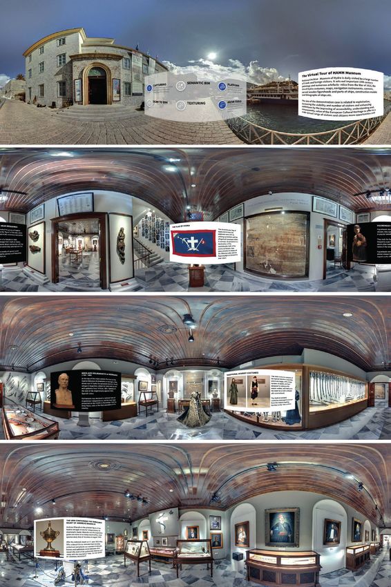
Inquadramento e ambito di indagine
Il rilievo, la documentazione e la valorizzazione degli spazi e dell’allestimento dell’Historical
Archives Museum (HAMH) a Hydra (Grecia) si inquadra nell’ambito dei casi studio del
progetto INCEPTION [1] ed è stato realizzato con collaborazione logistico-organizzativa di
VBC - Vision Business Consultants. L’obiettivo principale della sperimentazione consisteva nel
potenziare e sviluppare strumenti comunicativi a integrazione dei media utilizzati all’interno
del museo.
A tal fine, la piattaforma INCEPTION, grazie alle sue potenzialità di integrazione tra modelli
tridimensionali e il mondo del Semantic Web, è stata utilizzata come elemento aggregatore
di tutte le informazioni specifiche raccolte, descrittive sia di aspetti materiali che immateriali,
offrendo inoltre un punto di accesso 3D tramite lo sfruttamento del valore informativo di
modelli BIM-based. Questo strumento ha permesso poi il loro impiego sia come ausilio alle
strategie di decision making del museo in termini conservativi e per applicazioni web-mobile
di realtà virtuale (VR) a scopo turistico-informativo, divulgativo e di marketing culturale.
L’obiettivo primario del caso studio, ancorché basato sulle strategie di valorizzazione digitale,
mira ad aumentare la visibilità del sistema museale e delle sue mostre al fine di aumentare il
numero di visitatori e offrir loro un miglioramento della comprensione dei percorsi.
Principali obietti e azioni del progetto
A tal fine, si è proceduto secondo le seguenti azioni principali.
1. Identificare parti rappresentative delle collezioni storiche, come dipinti, archivi e map-
pe, così come l’edificio stesso, da rilevare, fotografare e modellare in 3D, creando una
parte del dataset di informazioni digitali di HAMH.
2. Sviluppare, testare e validare un’applicazione mobile che faccia uso di tecnologie AR/
VR per il tour del museo. Infatti, l’utilizzo del modello 3D all’interno di un’applicazione
di realtà virtuale può fornire un’esperienza di visita al museo integrativa.
3. Estendere l’uso dei dati a fini gestionali. L’edificio, visto come anche contenitore mu-
seale oltre che come bene documentale, necessita anche di una valutazione delle
condizioni di esercizio e programmazione delle manutenzioni.
Il valore storico-testimoniale del museo e della sua collezione
L’Historical Archives Museum viene formalmente istituito nel 1918 come testimoniato nella
Government Gazette dell’Aprile di quell’anno [2] [Adamopoulou-Pavlou 1997, p. 38] per
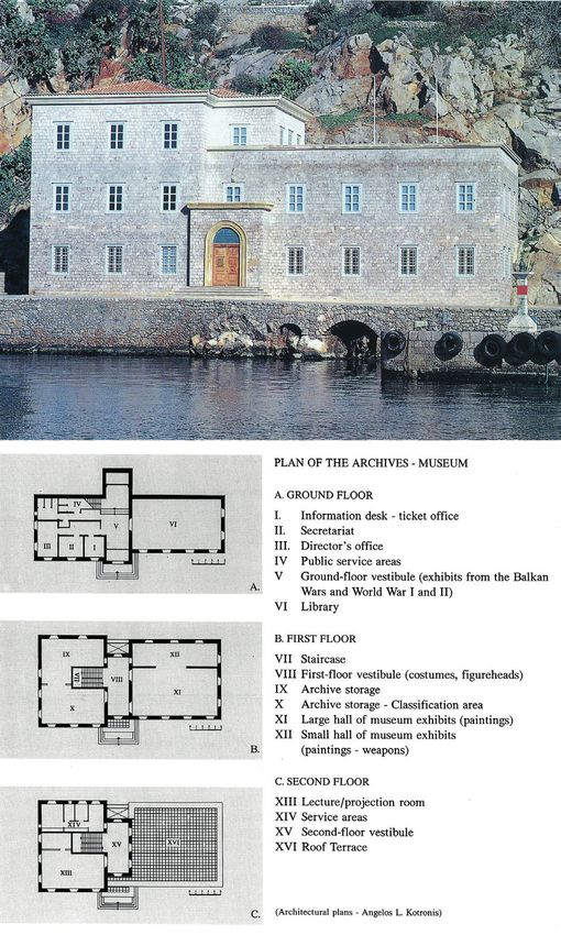
Fig. 1. L’isola di Hydra
(Grecia) è situata nel
golfo Saronico (mar
Egeo), presso il suo
limite con il golfo
Argolico. L’Historical
Archives Museum si
trova nell’unico borgo
dell’isola, sul lato nord,
affacciato sul piccolo
porto. In basso a sinistra
la mappa dell’isola redatta
dal geografo Antonios
Miliarakis (XIX secolo)
e a destra una vista
dell’isola di fine 18esimo
secolo (Castellan del
et Sculp | Letters sur la
Moree’ – Paris 1808)
[Adamopoulou-Pavlou
1997, pp. 19-20].
2472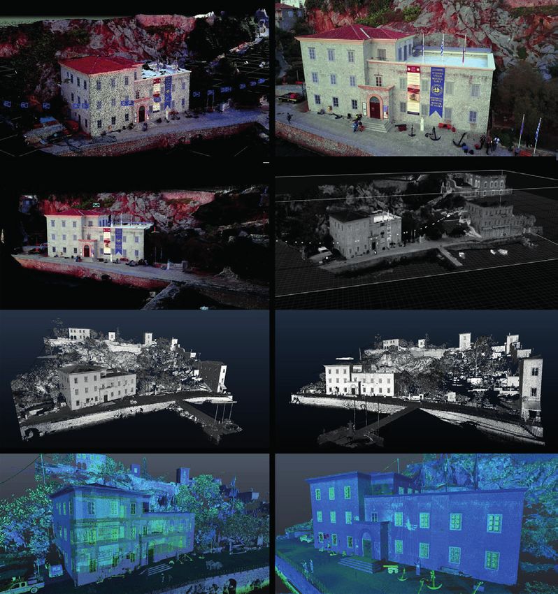
Fig. 2. Collages fototecnici
di Albumine (inizio ‘900)
che riprendono il porto
di Hydra prima della
costruzione del museo
(Archivio HAMH 917.5/
XVI/Ge4712 e 814.6/
XVI /Ge 4734).

                               la raccolta e la conservazione del patrimonio culturale dell’isola, grazie all’impegno di due
                               autorità originarie di Hydra: Antonios D. Lignos e Ghikas N. Koulouras.
                               L’isola infatti ha ricoperto un ruolo fondamentale nella storia della Grecia già a partire dal
                               XVIII secolo quando si sviluppò un’ampia flotta commerciale. Agli inizi del XIX risale la co-
                               struzione delle più importanti residenze, proprietà dei ricchi armatori, edifici in pietra a tre
                               o quattro piani (fig. 2).
                               Il primo edificio del museo fu realizzato nel 1919 (fig. 3), progettato dal noto architetto Ana-
                               stasios Orlandos. Ritenuto però non conforme allo stile architettonico austero e spartano
                               delle architetture presenti sull’isola, il 23 febbraio 1972 l’edificio fu demolito. La costruzione
                               del nuovo progetto, affidato all’architetto idriota Angelos L. Kotronis, segue anche esso un
                               travagliato percorso: la costruzione iniziata nell’ottobre 1975 si conclude con l’allestimento
                               delle sale espositive nel 1995. ll nuovo edificio di HAMH viene inaugurato ufficialmente il 6
                               luglio 1996 (fig. 4).

Fig. 3. Il primo edificio
realizzato come sede
museale nel 1919,
progettato da Anastasios
Orlandos, soffre già
dalla sua costruzione
di rilevanti problemi
costruttivi, che ne
determineranno la
demolizione nel 1972
per lasciare spazio alla
costruzione di nuovo
e più grande edificio
[Adamopoulou-Pavlou
1997, p. 42].

                                                                 2473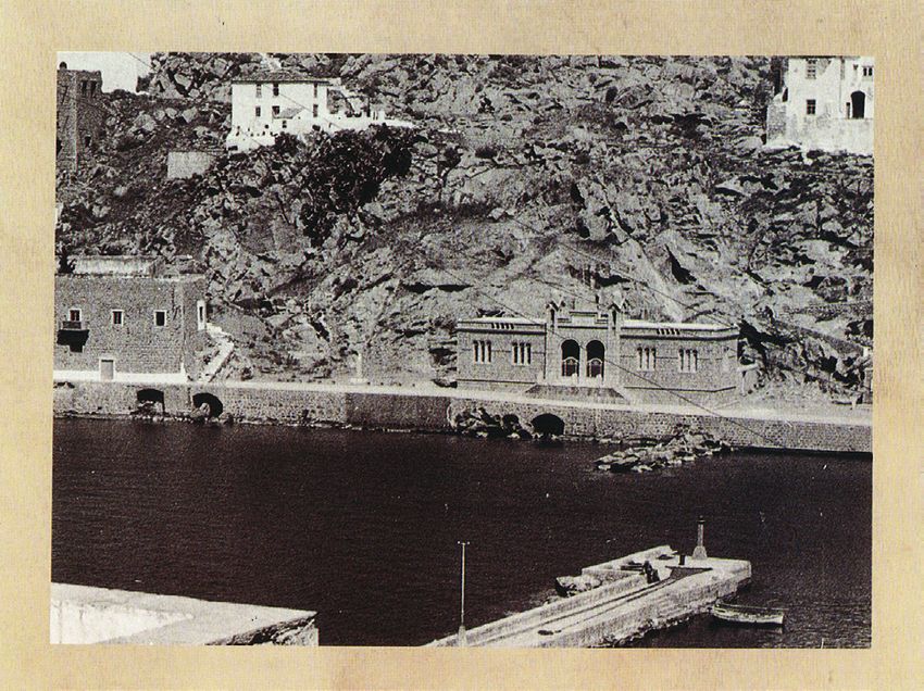
Fig. 4. Anche il nuovo
edificio, progettato
da Hydriot Angelos
L. Kotronis, segue un
travagliato percorso:
la costruzione iniziata
nell’ottobre 1975
si conclude con
l’allestimento delle sale
espositive nel 1995,
per essere inaugurato
ufficialmente il 6 luglio
1996 [Adamopoulou-
Pavlou 1997, pp. 43-45].

                            2474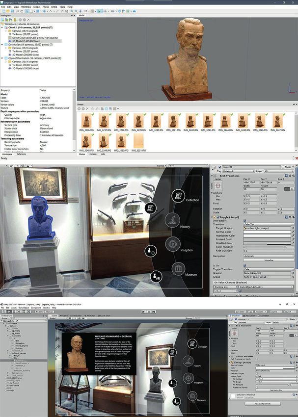
L’ampio edificio (circa 1.000 metri quadrati di superficie), posto sul lato nord del porto
di Hydra, si presenta ancora oggi architettonicamente solido e in armonia con l’ambiente
circostante e le architetture del luogo, accogliendo ancora turisti e studiosi che vogliono ap-
profondire gli eventi storici e culturali degli ultimi due secoli di questa regione della Grecia.
Oggi, il Museo dell’Archivio Nazionale di Hydra viene visitato quotidianamente da un gran
numero di visitatori greci e stranieri ed espone importanti dipinti del XIX secolo e numerosi
manufatti a cui si aggiungono circa 18.000 manoscritti e 122 codici, libri mastri, ecc. ospitati
nell’archivio e che possono essere di particolare interesse per storici e ricercatori [Adamo-
poulou-Pavlou 2015].

Metodologia di rilievo e documentazione tridimensionale

La complessità sopra descritta ha richiesto una metodologia di rilievo e documentazione
tridimensionale che potesse, da un lato, integrare molteplici metodi e strumenti di acqui-
sizione dati e che, dall’altro, ne permettesse la loro aggregazione e il successivo riutilizzo.
Per tale motivo si è optato per la realizzazione dei modelli BIM-based utilizzabili sia per la
documentazione e gestione dell’edificio che per la realizzazione di applicazioni di AR e VR.
Diverse tecniche di acquisizione, integrate tra loro, sono state scelte in funzione degli scopi
specifici seguendo le linee guida identificate nel protocollo di rilievo sviluppato all’interno
del progetto INCEPTION [Di Giulio et al. 2017].

Il rilievo dell’edificio e la sua modellazione BIM
Per il rilievo dell’edificio museale si è utilizzata una metodologia ibrida, oggi consolidata, che
si avvale di laser scanner terrestre come base di integrazione della fotogrammetria aerea
[Nex, Remondino 2014] registrate tramite inquadramento topografico. Il laser scanner ter-
reste utilizzato per il rilievo degli interni del museo e per l’esterno dell’intero complesso
è stato il Faro LS 330, mentre la fotogrammetria aerea da drone [Fatta et al. 2017], per il
modello delle coperture e delle parti del complesso in elevazione difficilmente raggiungibili
a causa dell’orografia del terreno e della vegetazione, è stata svolta mediante acquisizione
fotografica da DJI Mavic Pro.
Il rilievo laser scanner terreste (98 scansioni con 9,3 mm errore residuo) è stato registra-
to direttamente sulla rete topografica esistente (materializzata con capisaldi in loco sia in
esterno che nel salone principale). Il modello così ottenuto è servito, insieme ai capisaldi
topografici visibili dal drone (n. 5), come appoggio alla procedura di allineamento alla fo-
to-modellazione (per un totale di 483 immagini processate) per migliorare la precisione e
ridurre gli errori di deriva (fig. 5).
Tale rilievo ha poi permesso di procedere con una modellazione BIM architettonica, rea-
lizzata con il software Autodesk Revit 2016. Il modello, sviluppato con un LOD adeguato
all’inclusione di tutte le informazioni derivanti dai rilievi dell’edificio così come dalla docu-
mentazione manufatti qui contenuti, è stato pertanto strutturato con una organizzazione in-
formativa che potesse permettere di essere utilizzato dal museo e dai tecnici in sostituzione
dei disegni 2D CAD esistenti, per scopi gestionali e manutentivi.
Integra la documentazione, anche a integrazione del modello BIM, una campagna fotografi-
ca, composta da 56 foto sferiche 360°, per la costruzione di un Virtual Tour del complesso in
applicazioni off-site, principalmente legate al web-browsing. Le immagini alta risoluzione (equi-
rettangolare da 10.000x5.000px) sono state acquisite in HDR tramite Ntech iStar. Il Virtual
Tour è stato poi realizzato con 22 delle immagini acquisite e successivamente popolate delle
informazioni contestuali.

La documentazione 3D dei manufatti della collezione museale
Particolare attenzione è stata rivolta alla documentazione 3D dei manufatti all’interno del
museo e la creazione dei loro modelli digitali. Per l’acquisizione sono state impiegate sia
tecnologie laser scanner (Faro Ls330) per le gli apparati decorativi e dettagli di scala archi-
tettonica (come modanature e porte di accesso alle ricche abitazioni dell’isola o apparati

                                  2475
relativi a imbarcazioni o alla navigazione in genere), sia tecniche fotogrammetriche (Canon
                                 5D Mark2 - 50mm f1,4) per la statuaria, la customistica e l’oggettistica. In entrambi i casi ci
                                 si è avvalsi dell’uso di target per la registrazione e il processamento dei dati.
                                 Complessivamente i manufatti oggetto della campagna di documentazione e dei quali sono
                                 stati creati modelli tridimensionali ammontano a circa una trentina, scelti tra quelli con il
                                 significato simbolico più importante [Adamopoulou-Pavlou 2015]. Tra questi una polena
                                 rappresentante una figura femminile in stile vernacolare che culla tra le braccia un piccolo
                                 leone, diversi akrostolia, (decorazioni della prua), cinque costumi tradizionali idrioti, alcune
                                 pistole della collezione dell’HAMH, un elaborato vaso d’argento intitolate all’ammiraglio
                                 Miaoulis e il busto dell’idriota Nikolaos Kolmaniatis.

                                 L’arricchimento semantica del modello BIM e la popolazione con documentazioni allegata
                                 Il modello BIM architettonico realizzato diviene quindi l’elemento aggregatore di tutta la
                                 digitalizzazione degli artefatti e ne rende possibile il loro collegamento sia digitale che di si-
                                 gnificato, grazie allo sfruttamento del Semantic Web. Il modello, compatibile con lo standard
                                 IFC 2x3, è stato infatti caricato sulla piattaforma INCEPTION [Maietti et al. 2020], dove sono
                                 stati convertiti in TTL [Bonsma et al. 2018] tutte le componenti modellate, sia architetto-
                                 niche che di arredo espositivo, per essere ulteriormente arricchite sia semanticamente sia

Fig. 5. Il rilievo dell’intero
complesso del Museo
è stato effettuato
utilizzando con una
metodologia ibrida,
integrando i dati da
laser scanner terrestre
con quelli della
fotogrammetria aerea
per raggiungere le aree
non raggiungibili da terra,
come le coperture o
sovra squadri.

                                                                   2476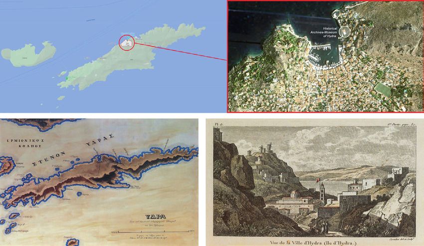
Fig. 6. Il modello
BIM, realizzato con il
software Autodesk
Revit 2016, è stato
caricato all’interno della
piattaforma INCEPTION
per essere arricchito
semanticamente e per
collegare allegati
ai singoli elementi.
Nell’immagine, uno
screenshot della
piattaforma in modalità
di visualizzazione blended
tra modello BIM e il
rilievo 3D.

                             con allegati di diverso tipo (PDF, relazioni strutturali, termografie, immagini, modelli 3D di
                             dettaglio, ecc.), riferiti ai singoli elementi del modello BIM. A singolo oggetto tridimensio-
                             nale è quindi attributo un URI (Unique Reference Identifier) che, posto alla base del sistema
                             delle triple semantiche, rende possibile riferire in maniera univoca a ogni elemento le
                             informazioni già contenute nel file IFC, gli allegati successivamente collegati mediante la
                             piattaforma, nonché eventuali collegamenti diretti con archivi storici resi disponibili come
                             Open Linked Data.
                             La diversità dei modelli e la complessità informazioni contenute richiedono però, al
                             tempo stesso, un efficace sistema di fruizione (fig. 6). In tal senso, la piattaforma IN-
                             CEPTION può filtrare le diverse tipologie di dati in funzione della tipologia utenti. In
                             questo caso, poiché sono disponibili informazioni su dati tecnici e/o operativi, il tecnico
                             del museo può, ad esempio, facilmente scegliere tra le informazioni importanti per la

                                                             2477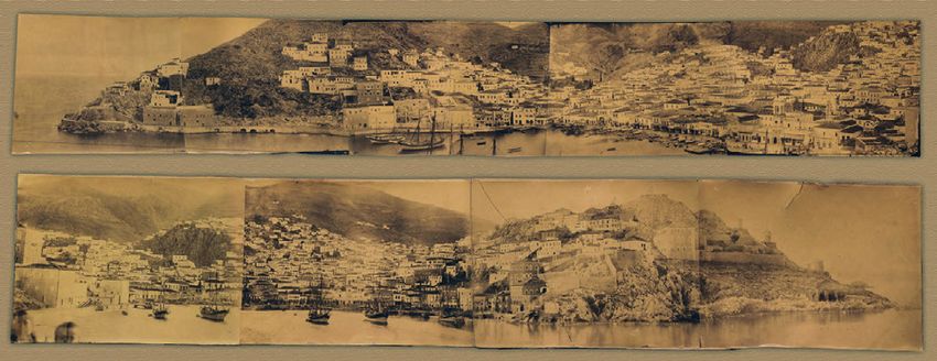
valutazione delle condizioni della struttura o la programmazione della manutenzione,
                          mentre lo studioso può decidere di visualizzare le sole informazioni storico-archivistiche
                          collegate alla geometria, la documentazione fotografica 360 degli ambienti o le digitaliz-
                          zazioni degli artefatti.

Fig. 7. ll Virtual Tour
del museo interattivo
è stato realizzato
con 22 delle 56
foto sferiche 360°,
acquisite durante la
campagna di rilievo,
ed è stato pensato
principalmente per
l’utilizzo via browser
web, headset VR all-
in-one o dispositivi
mobile.

                                                         2478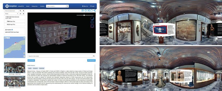
Risultati e applicazioni di AR/VR per la fruizione dei contenuti documentati

A partire del rilievo e dal modello BIM, nell’integrazione con i modelli di dettaglio di statue,
vestiti e altra oggettistica esposta nella collezione del museo, resa possibile dall’integrazione
della piattaforma INCEPTION, si realizzato in maniera concreta un modello multiscalare
dell’intero complesso museale. Lo stesso ha quindi aperto alla realizzazione di ulteriori
esperienze di fruizione dei dati, anche grazie alla creazione di applicazioni di realtà Virtuale
(VR) o Aumentata (AR) [Parrinello et al. 2016]. In alcuni casi i modelli già realizzati sono
stati ulteriormente processati, ottimizzati e ridefiniti tramite modellatori per superfici, anche
NURBS, come Rhino o Sketchup [Ausonio et al. 2018].
Nella configurazione dei modelli è stato di fondamentale importanza la definizione a priori
della logica di storytelling che la comunicazione in AR/VR avrebbe sviluppato [Keil et al. 2013].
La navigazione del Virtual Tour del museo e della collezione museale qui contenuta, fruibile sia da
desktop che da mobile e con la possibilità di attivare una modalità immersiva (con Head-Moun-
ted Display HMD di tipo fisso o portatile), ha permesso di porre l’accento sulla narrazione
grazie alla possibilità di guidare l’utente tra le stanze rispetto a un percorso predefinito e di-
sponendo contenuti aggiuntivi stanza per stanza con maggiore facilità. Nel Virtual Tour prodotto,
realizzato in modalità raster-based a partire dalle foto 360° (fig. 7), gli oggetti prendono vita e
richiamano l’attenzione del visitatore digitale mediante l’impiego di pop-up tridimensionali.
Inoltre, la visita on-site è stata arricchita mediante lo sviluppo di un’app AR per smartphone
(fig. 8) che valorizza la visualizzazione degli artefatti grazie al loro riconoscimento nella col-
lezione museale sulla base di forma, dimensione, aspetto e localizzazione. La tecnologia di
riconoscimento utilizzata è basta sugli algoritmi resi disponibili da Vuforia per lo sviluppo in
ambiente Unity. Grazie alla disponibilità di una connessione 4G o Wi-Fi (entrambe disponi-
bili sul posto), gli oggetti della collezione museale diventano quindi punti di accesso [Brusa-
porci et al. 2017] per la fruizione di contenuti online aggregati sulla piattaforma INCEPTION
che, in tal modo, vengono da lì direttamente e dinamicamente prelevati, nella loro versione
più aggiornata, sfruttando una logica di recupero on-the-fly.

Conclusioni e sviluppi futuri

Il caso studio della digitalizzazione di HAMH ha permesso di dimostrare come una efficace
sinergia tra importati innovazioni tecnologiche e piccoli sistemi museali locali possa funzio-
nare solo se facilitata da specifici attori, ruolo in questo caso svolto da VBC. Sebbene il po-
tenziale delle applicazioni di AR e VR nel settore dei beni culturali e in particolare in quello
museale sia comprovato e migliori l’esperienza di visita, non sempre la singola amministra-
zione museale è in grado di accedere a tali vantaggi. Il ruolo fondamentale di un facilitatore
informato ha in questo caso reso disponibile l’adozione delle più moderne tecnologie in
maniera consapevole.
In conclusione, sebbene non sia possibile allo stato attuale fornire dati significati sull’aumen-
tata visibilità di questo sistema museale e delle sue mostre o sull’aumentare il numero di
visitatori anche in virtù dell’attuale condizione pandemica, anche la sola possibilità di poter
apprezzare gli oggetti esposti in un periodo storico di riduzione della mobilità globale è
elemento di valutazione favorevole del progetto stesso. Inoltre, è possibile affermare che,
con una maggiore disponibilità di prodotti e servizi che il museo può offrire proprio in virtù
di questa digitalizzazione, si è di certo ampliata la base potenziale di utenti con cui HAMH
si può relazionare. Resta di certo l’utente principale del museo il visitatore stagionale che
si trova sull’isola di Hydra per una breve soggiorno di piacere, ma a questo si aggiungono
in maniera decisamente più consistente rispetto a prima il visitatore digitale interessato alla
comprensione della più recente storia della Grecia così come lo studioso internazionale che,
per la prima volta, può accedere a contenuti unici prima disponibili solo in loco.
In ultimo, le tecniche di digitalizzazione tridimensionale combinate con il web e gli strumenti
di XR (Extended Reality) divengono nuovo strumento lessicale di dialogo e racconto per
differenti attori, aprendo efficaci riutilizzi per finalità multidisciplinari.

                                  2479
Fig. 8. Esempio
di sviluppo di
applicazione di
realtà aumentata
AR sul busto del
Capitano Nikolaou G.
Kolmaniati (Nicolas
Jorge Colmaniatis)
che, dopo essere
immigrato in
Argentina nel 1811,
si arruolò marinaio e
raggiunse il grado di
contrammiraglio, un
Idriota eroe nazionale
d’Argentina.
Note
[1] Sperimentazione effettuata all’interno del progetto europeo INCEPTION - Inclusive Cultural Heritage in Europe through 3D
semantic modelling, conclusosi a Maggio 2019 e finanziato della Commissione Europea nell’ambito del Programma Horizon
2020, Research and Innovation Action sotto il Grant Agreement No. 665220.
[2] Government Gazette, n. 82, 16 April 1918.
2480Riferimenti bibliografici
Adamopoulou-Pavlou C. (1997). Hystorical Archives - Museum Of Hydra. Atene, Greece: Artigraf.
Adamopoulou-Pavlou C. (2001). Hydra. Hydra, Greece: Vergas.
Adamopoulou-Pavlou C. (2015). Catalogue of H.A.M. of Hydra. Hydra, Greece: HAMH.
Ausonio E. et al. (2018). Potenzialità dei software Free e/o Open Source per la modellazione, gestione e fruizione di entità 3D.
In Geomatics Workbooks, n. 14 - FOSS4G-it, pp. 4-20.
Bonsma P. et al. (2018). Handling huge and complex 3D geometries with Semantic Web technology. In IOP Conference Series:
Materials Science and Engineering, vol. vol. 364 012041, pp. 1-7.
Brusaporci S. et al. (2017) Augmented Reality for Historical Storytelling. The INCIPICT Project for the Reconstruction of
Tangible and Intangible Image of L’Aquila Historical Centre. In Proceedings, 1, 1083.
Di Giulio R. et al. (2017). Integrated data capturing requirements for 3D semantic modelling of Cultural Heritage: the INCEP-
TION protocol. In Int. Arch. Photogramm. Remote Sens. Spatial Inf. Sci., XLII-2/W3, pp. 251-257.
Fatta F., Bassetta M., Manti A. (2017). Survey Methodologies, Research and Technological Innovation for a Case of Medieval
Archaeology: Torre Melissa in the province of Crotone. In Disegnarecon, 10(19), pp. 6.1 - 6.17.
Keil J. et al. (2013). A digital look at physical museum exhibits: Designing personalized stories with handheld Augmented Reality
in museums. In Digital Heritage International Congress, vol. 2, pp. 685-688.
Maietti F. et al. (2020). Documentation, Processing, and Representation of Architectural Heritage Through 3D Semantic Mod-
elling: The INCEPTION Project. In C. Bolognesi, C. Santagati (Eds.). Impact of Industry 4.0 on Architecture and Cultural Heritage,
pp. 202-238. Hershey, PA: IGI Global.
Nex F., Remondino F. (2014). UAV for 3D mapping applications: a review. In Applied geomatics, 6(1), pp. 1-15.
Parrinello S., Picchio F., Bercigli M. (2016). La ‘migrazione’ della realtà in scenari virtuali: Banche dati e sistemi di documentazione
per la musealizzazione di ambienti complessi. Musei virtuali dell’architettura e della città. In Disegnarecon, 9(17), pp. 14-1.
Spiliotis S.F. (1998). The secret Hydra. Hydra, Greece: Kyveli.
Autori
Marco Medici, Università di Ferrara, marco.medici@unife.it
Federico Ferrari, Università di Ferrara, federico.ferrari@unife.it
Per citare questo capitolo: Medici Marco, Ferrari Federico (2021). Realtà Virtuale e Aumentata per la valorizzazione dell’Historical Archives Mu-
seum di Hydra/Virtual and Augmented Reality Applications for Enhancement of the Historical Archives Museum of Hydra. In Arena A., Arena
M., Mediati D., Raffa P. (a cura di). Connettere. Un disegno per annodare e tessere. Linguaggi Distanze Tecnologie. Atti del 42° Convegno Internazionale
dei Docenti delle Discipline della Rappresentazione/Connecting. Drawing for weaving relationship. Languages Distances Technologies. Proceedings of the
42th International Conference of Representation Disciplines Teachers. Milano: FrancoAngeli, pp. 2471-2492.
Copyright © 2021 by FrancoAngeli s.r.l. Milano, Italy Isbn 9788835125891
248142th International Conference
of Representation Disciplines Teachers
Congress of Unione Italiana per il Disegno
Virtual and Augmented Reality
Applications for Enhancement of the
Historical Archives Museum of Hydra
Marco Medici
Federico Ferrari
Abstract
The paper presents the experience of survey, documentation, and valorization of the Historical
Archives Museum in Hydra. For the survey of the architectural complex, a hybrid methodology was
used, nowadays consolidated, which uses both laser scanner tools and photogrammetric techniques,
also for the documentation of the exposed artifacts. Furthermore, thanks to the creation of a BIM
model and its integration on the INCEPTION platform, it was possible to store and connect detailed
models of statues, clothes, and other objects, creating a multiscale model of the entire museum com-
plex, both for popular and technical purposes. This model was then the basis, through appropriate
optimizations, to create immersive environments of Virtual and Augmented Reality for a better un-
derstanding and enjoyment of the value of the museum works exhibited here.
Keywords
surveying, documentation, virtuality, Virtual Reality, Augmented Reality.
The synergy between
the INCEPTION
platform and the most
modern tools for the
creation of immersive
realities, made possible by
the use of interoperable
standards, allows an
advanced fruition of
online contents. In the
image, an example of
spherical images that can
be retrieved on-the-fly
from the platform.
doi.org/10.3280/oa-693.139
2482Framework and scope of the investigation
The survey, documentation, and enhancement of the spaces and the layout of the His-
torical Archives Museum (HAMH) in Hydra (Greece) is part of the case studies of the
INCEPTION project [1] and was carried out with the logistical and organizational collab-
oration of VBC - Vision Business Consultants. The main objective of the experimentation
was to strengthen and develop communication tools to integrate the media used within
the museum.
To this end, the INCEPTION platform, thanks to its potentiality of integration between
three-dimensional models and the Semantic Web world, has been used as an aggregator
element of all the specific information collected, descriptive of both material and immaterial
aspects, offering also a 3D access point through the exploitation of the informative value
of BIM-based models. This tool has then allowed their use both to aid the museum’s deci-
sion-making strategies in terms of conservation and for web-mobile applications of virtual
reality (VR) for tourism-informative, dissemination, and cultural marketing purposes.
Although based on digital enhancement strategies, the primary objective of the case study
is to increase the visibility of the museum system and its exhibitions to increase the number
of visitors and offer them a better understanding of the routes.
Main objectives and actions of the project
To this end, the following main actions were taken.
1. Identify representative parts of the historical collections, such as paintings, archives, and
maps, as well as the building itself, to be surveyed, photographed, and modeled in 3D,
creating a part of HAMH’s digital information dataset.
2. Develop, test, and validate a mobile application that uses AR/VR technologies for mu-
seum tours. Using the 3D model within a virtual reality application can provide an
integrative museum tour experience.
3. Extend the use of data for management purposes. The building, seen as a museum
container and a documentary asset, also needs an evaluation of its operating condi-
tions and maintenance schedule.
The historical-testimonial value of the museum and its collection
The Historical Archives Museum was formally established in 1918 as witnessed in the Gov-
ernment Gazette of April of that year [2] [Adamopoulou-Pavlou 1997, p. 38] for the collec-
Fig. 1. L’isola di Hydra
(Grecia) è situata nel
golfo Saronico (mar
Egeo), presso il suo
limite con il golfo
Argolico. L’Historical
Archives Museum si
trova nell’unico borgo
dell’isola, sul lato nord,
affacciato sul piccolo
porto. In basso a sinistra
la mappa dell’isola redatta
dal geografo Antonios
Miliarakis (XIX secolo)
e a destra una vista
dell’isola di fine 18esimo
secolo (Castellan del
et Sculp | Letters sur
la Moree’- Paris 1808)
[Adamopoulou-Pavlou
1997, pp. 19-20].
2483Fig. 2. Photographic
collages by Albumine
(early 20th century)
showing the port of
Hydra before the
construction of the
museum (HAMH
Archives 917.5/XVI/
Ge4712 and 814.6/ XVI /
Ge 4734).
tion and preservation of the island’s cultural heritage, thanks to the efforts of two authori-
ties originally from Hydra: Antonios D. Lignos and Ghikas N. Koulouras.
The island played a fundamental role in the history of Greece since the 18th century, when a
large commercial fleet developed. At the beginning of the XIX century dates the construc-
tion of the most important residences, property of the wealthy shipowners, stone buildings
with three or four floors (fig. 2).
The first museum building was constructed in 1919 (fig. 3), designed by the renowned
architect Anastasios Orlandos. However, since it was not considered in keeping with the
island’s architecture’s austere and spartan architectural style, the building was demolished
on February 23, 1972.The construction of the new project, entrusted to the Idriot architect
Angelos L. Kotronis, also followed a troubled path: the construction began in October 1975
and ended with installing the exhibition halls in 1995. The new building of HAMH was offi-
cially inaugurated on July 6, 1996 (fig. 4).
Fig. 3. The first building
constructed as the
museum’s headquarters
in 1919, designed by
Anastasios Orlandos,
suffered from significant
construction problems as
early as its construction,
which led to its
demolition in 1972 to
make way for the
construction of a new,
larger building [1997,
Adamopoulou-Pavlou,
p. 42].
2484Fig. 4. The new building,
designed by Hydriot
Angelos L. Kotronis, also
followed a troubled path:
construction began in
October 1975 and ended
with the installation
of the exhibition
halls in 1995, to be
officially inaugurated
on July 6, 1996 [1997,
Adamopoulou-Pavlou, p.
43, p. 45].
2485The large building (about 1,000 square meters in area), located on the north side of the
port of Hydra, is in harmony with the surrounding environment and the architecture of the
place, still welcoming tourists and scholars who want to learn more about the historical and
cultural events of the last two centuries of this region of Greece.
Today, the Museum of the National Archives of Hydra is visited daily by a large number
of Greek and foreign visitors and exhibits important 19th century paintings and numerous
artifacts in addition to about 18,000 manuscripts and 122 codices, ledgers, etc. housed in
the archive that may be of particular interest to historians and researchers [Adamopou-
lou-Pavlou 2015].
Methodology of three-dimensional survey and documentation
The complexity described above required a three-dimensional survey and documentation
methodology that could, on the one hand, integrate multiple data acquisition methods and
tools and, on the other, allow their aggregation and subsequent reuse. For this reason, we
opted for the realization of BIM-based models that can be used for the documentation and
management of the building and the realization of AR and VR applications. According to
the specific purposes, different acquisition techniques were chosen following the guidelines
identified in the survey protocol developed within the INCEPTION project [Di Giulio et
al. 2017].
The survey of the building and its BIM modeling
For the survey of the museum building, a hybrid methodology, now consolidated, was used,
using terrestrial laser scanner as a basis for the integration of aerial photogrammetry [Nex,
Remondino 2014] recorded through topographic framing.The terrestrial laser scanner used
for the survey of the museum’s interior and the exterior of the entire complex was the
Faro LS 330. In contrast, aerial photogrammetry from a drone [Fatta et al. 2017], for the
model of the roofs and the parts of the complex in elevation that are difficult to reach due
to the orography of the terrain and vegetation, was carried out by photo acquisition from
DJI Mavic Pro.
The terrestrial laser scanner survey (98 scans with 9.3mm residual error) was recorded
directly on the existing topographic network (materialized with in situ cornerstones out-
side and the main hall). The model thus obtained served, together with the topographic
cornerstones visible from the drone (No. 5), as support for the photo-modeling alignment
procedure (for a total of 483 processed images) to improve accuracy and reduce drift
errors (fig. 5).
This survey then allowed us to proceed with an architectural BIM modeling, realized with
Autodesk Revit 2016 software. The model, developed with a LOD adequate for the inclu-
sion of all the information derived from the building surveys as well as from the documen-
tation artifacts contained herein, was therefore structured with an information organization
that could allow it to be used by the museum and its technicians in place of the existing 2D
CAD drawings, for management and maintenance purposes.
The BIM model is integrated by a photographic campaign composed of 56 360° spherical
photos to construct a Virtual Tour of the complex in off-site applications, mainly related
to web-browsing. The high-resolution images (10.000x5.000px equirectangular) have been
acquired in HDR through Ntech iStar. The Virtual Tour was then created with 22 of the
acquired images and subsequently populated with contextual information.
The 3D documentation of the artifacts of the museum collection
Particular attention was paid to the 3D documentation of the artifacts inside the museum
and the creation of their digital models. Laser scanning technologies (Faro Ls330) were used
for the acquisition of the decorative devices and details on an architectural scale (such as
moldings and access doors to the island’s rich dwellings or devices related to boats or nav-
igation in general), as well as photogrammetric techniques (Canon 5D Mark2 - 50mm f1.4)
2486for the statuary, custom, and objects. In both cases, the use of targets was used for recording
and processing data.
In total, the artifacts that were the subject of the documentation campaign and of which
three-dimensional models were created amount to about thirty, chosen from those with
the most essential symbolic meaning [Adamopoulou-Pavlou 2015]. These include a figure-
head representing a vernacular female figure cradling a small lion in her arms, several ak-
rostolia, (bow decorations), five traditional Idriot costumes, several guns from the HAMH
collection, an elaborate silver vase named after Admiral Miaoulis, and the bust of the Idriot
Nikolaos Kolmaniatis.
The semantic enrichment of the BIM model and the population with attached documentation
The realized architectural BIM model thus becomes the aggregating element of all the digiti-
zation of the artifacts and makes possible their connection both digital and meaning, thanks
to exploiting the Semantic Web. The model, compatible with the IFC 2x3 standard, was
uploaded to the INCEPTION platform [Maietti et al. 2020], where all the modeled com-
ponents, both architectural and exhibition furniture, were converted into TTL [Bonsma et
al. 2018], to be further enriched both semantically and with attachments of different types
(PDF, structural reports, thermographs, images, detailed 3D models, etc.), referring to the
Fig. 5. The survey of
the entire Museum
complex was carried
out using a hybrid
methodology, integrating
data from terrestrial
laser scanners with aerial
photogrammetry data
to reach areas that could
not be reached from the
ground, such as roofs or
overhangs.
2487Fig. 6. The BIM model,
created with Autodesk
Revit 2016 software,
was uploaded on the
INCEPTION platform to
be semantically enriched
and to link attachments
to individual elements.
In the image, a screenshot
of the platform in
blended visualization
mode between the BIM
model and the 3D survey.
single elements of the BIM model. A URI (Unique Reference Identifier) is then attributed to
each three-dimensional object which, placed at the base of the system of semantic triples,
makes it possible to refer univocally to each element the information already contained in
the IFC file, the attachments subsequently linked through the platform, as well as any direct
links with historical archives made available as Open Linked Data.
The diversity of models and the complexity of the information they contain require, at the same
time, an effective system of use (fig. 6). In this sense, the INCEPTION platform can filter the dif-
ferent types of data according to the kind of user. In this case, since information on technical and/
or operational data is available, the museum technician can, for example, easily choose between
information that is important for assessing the condition of the structure or planning maintenance.
At the same time, the scholar can decide to view only historical-archival information related to
geometry, photographic documentation 360 of the environments, or digitalization of artifacts.
2488Fig. 7. The Virtual Tour
of the interactive
museum has been
realized with 22 of the
56 spherical photos,
captured during the
survey campaign, and
has been designed
mainly for use via web
browser, all-in-one
VR headset or mobile
devices.
2489Results and applications of AR/VR for the fruition of documented content
Starting from the survey and the BIM model, integrating the detailed models of statues,
clothes, and other objects exhibited in the museum collection, made possible by com-
bining the INCEPTION platform, a multiscalar model of the entire museum complex is
realized concretely. The same has then opened to the realization of other experiences of
data fruition, also thanks to the creation of Virtual Reality (VR) or Augmented Reality (AR)
applications [Parrinello et al. 2016]. In some cases, the models already created were further
processed, optimized, and redefined using surface modelers, including NURBS, such as Rhi-
no or Sketchup [Ausonio et al. 2018].
In configuring the models, the a priori definition of the storytelling logic that AR/VR com-
munication would develop was of paramount importance [Keil et al. 2013]. The navigation
of the Virtual Tour of the museum and the museum collection contained herein, usable
both from desktop and mobile and with the possibility of activating an immersive mode
(with Head-Mounted Display HMD of fixed or portable type), allowed to emphasize the
narrative thanks to the possibility of guiding the user between the rooms concerning a
predefined path and arranging additional content room by room with greater ease. In the
Virtual Tour produced, realized in raster-based mode starting from 360° photos (fig. 7), the
objects come to life and draw the attention of the digital visitor through the use of three-di-
mensional pop-ups.
In addition, the on-site visit has been enriched through the development of an AR app for
smartphones (fig. 8) that enhances the visualization of artifacts through their recognition
in the museum collection based on shape, size, appearance, and location. The recognition
technology used is just on the algorithms made available by Vuforia for development in the
Unity environment. Thanks to the availability of a 4G or Wi-Fi connection (both available
on-site), the objects of the museum collection then become access points [Brusaporci et
al. 2017] for the fruition of online content aggregated on the INCEPTION platform that, in
this way, are directly and dynamically retrieved from there, in their most updated version,
exploiting an on-the-fly retrieval logic.
Conclusions and future developments
The case study of the digitization of HAMH allowed us to demonstrate how an effective
synergy between important technological innovations and small local museum systems can
work only if facilitated by specific actors, a role in this case played by VBC. Although the po-
tential of AR and VR applications in the cultural heritage sector and, in particular, in the mu-
seum sector is proven and improves the visitor experience, individual museum administra-
tion is not always able to access these benefits. The critical role of an informed facilitator, in
this case, has made the adoption of the latest technologies available in a conscious manner.
In conclusion, although it is not possible at this time to provide significant data on the
increased visibility of this museum system and its exhibits or the increase in the number
of visitors also by the current pandemic condition, even the mere possibility of being able
to appreciate the shows in a historical period of reduced global mobility is an element of
favorable evaluation of the project itself. Furthermore, it is possible to say that, with the
greater availability of products and services that the museum can offer precisely because
of this digitization, the potential user base with which HAMH can relate has undoubtedly
expanded. The main user of the museum remains the seasonal visitor to Hydra Island
for a short stay for pleasure, but the digital visitor interested in understanding the recent
history of Greece as well as the international scholar who, for the first time, can access
unique content previously available only on-site, have been added in a much more con-
sistent way than before.
Finally, three-dimensional digitization techniques combined with the web and XR (Extended
Reality) tools become a new linguistic tool for dialogue and storytelling for different actors,
opening up effective reuses for multidisciplinary purposes.
2490Fig. 8. Example of
Augmented Reality
application developed
on the bust of
Captain Nikolaou G.
Kolmaniati (Nicolas
Jorge Colmaniatis)
who, after immigrating
to Argentina in 1811,
enlisted as a sailor
and reached the rank
of Rear Admiral, an
Idriot national hero of
Argentina.
Notes
[1] Experimentation carried out within the European project INCEPTION - Inclusive Cultural Heritage in Europe through 3D
semantic modelling, concluded in May 2019 and funded by the European Commission under the Horizon 2020 Program,
Research and Innovation Action under Grant Agreement No. 665220.
[2] Government Gazette, n. 82 of 16 April 1918.
2491References
Adamopoulou-Pavlou C. (1997). Hystorical Archives - Museum Of Hydra. Atene, Greece: Artigraf.
Adamopoulou-Pavlou C. (2001). Hydra. Hydra, Greece: Vergas.
Adamopoulou-Pavlou C. (2015). Catalogue of H.A.M. of Hydra. Hydra, Greece: HAMH.
Ausonio E. et al. (2018). Potenzialità dei software Free e/o Open Source per la modellazione, gestione e fruizione di entità 3D.
In Geomatics Workbooks, n. 14 - FOSS4G-it, pp. 4-20.
Bonsma P. et al. (2018). Handling huge and complex 3D geometries with Semantic Web technology. In IOP Conference Series:
Materials Science and Engineering, vol. 364 012041, pp. 1-7.
Brusaporci S. et al. (2017) Augmented Reality for Historical Storytelling. The INCIPICT Project for the Reconstruction of
Tangible and Intangible Image of L’Aquila Historical Centre. In Proceedings, 1, 1083.
Di Giulio R. et al. (2017). Integrated data capturing requirements for 3D semantic modelling of Cultural Heritage: the INCEP-
TION protocol. In Int. Arch. Photogramm. Remote Sens. Spatial Inf. Sci., XLII-2/W3, pp. 251-257.
Fatta F., Bassetta M., Manti A. (2017). Survey Methodologies, Research and Technological Innovation for a Case of Medieval
Archaeology: Torre Melissa in the province of Crotone. In Disegnarecon, 10(19), pp. 6.1 - 6.17.
Keil J. et al. (2013). A digital look at physical museum exhibits: Designing personalized stories with handheld Augmented Reality
in museums. In Digital Heritage International Congress, vol. 2, pp. 685-688.
Maietti F. et al. (2020). Documentation, Processing, and Representation of Architectural Heritage Through 3D Semantic Mod-
elling: The INCEPTION Project. In C. Bolognesi, C. Santagati (Eds.). Impact of Industry 4.0 on Architecture and Cultural Heritage,
pp. 202-238. Hershey, PA: IGI Global.
Nex F., Remondino F. (2014). UAV for 3D mapping applications: a review. In Applied geomatics, 6(1), pp. 1-15.
Parrinello S., Picchio F., Bercigli M. (2016). La ‘migrazione’ della realtà in scenari virtuali: Banche dati e sistemi di documentazione
per la musealizzazione di ambienti complessi. Musei virtuali dell’architettura e della città. In Disegnarecon, 9(17), pp. 14-1.
Spiliotis S.F. (1998). The secret Hydra. Hydra, Greece: Kyveli.
Authors
Marco Medici, Università di Ferrara, marco.medici@unife.it
Federico Ferrari, Università di Ferrara, federico.ferrari@unife.it
To cite this chapter: Medici Marco, Ferrari Federico (2021). Realtà Virtuale e Aumentata per la valorizzazione dell’Historical Archives Museum di
Hydra/Virtual and Augmented Reality Applications for Enhancement of the Historical Archives Museum of Hydra. In Arena A., Arena M., Mediati
D., Raffa P. (a cura di). Connettere. Un disegno per annodare e tessere. Linguaggi Distanze Tecnologie. Atti del 42° Convegno Internazionale dei Docenti
delle Discipline della Rappresentazione/Connecting. Drawing for weaving relationship. Languages Distances Technologies. Proceedings of the 42th Inter-
national Conference of Representation Disciplines Teachers. Milano: FrancoAngeli, pp. 2471-2492.
Copyright © 2021 by FrancoAngeli s.r.l. Milano, Italy Isbn 9788835125891
2492Puoi anche leggere