LA CITTÀ CONTEMPORANEA: UN GIGANTE DAI PIEDI D'ARGILLA - Atti della conferenza internazionale a cura di Michele Talia - china room
←
→
Trascrizione del contenuto della pagina
Se il tuo browser non visualizza correttamente la pagina, ti preghiamo di leggere il contenuto della pagina quaggiù
XVI EDIZIONE URBANPROMO "PROGETTI PER IL PAESE"
TORINO, NUVOLA LAVAZZA, 15 NOVEMBRE 2019

LA CITTÀ
CONTEMPORANEA:
UN GIGANTE DAI
PIEDI D’ARGILLA
Atti della conferenza internazionale
a cura di Michele Talia
Seconda edizione riveduta e corretta giugno 2020
                                  Edizione prestampa novembre 2019
                         Staff editoriale: Laura Infante, Cecilia Saibene
                         Pubblicazione disponibile su www.planum.net
                                                ISBN 9788899237226
                                                      © Copyright 2020

                                                       Planum Publisher
                                                       www.planum.net
                                                           Roma-Milano

      All rights reserved. No part of this publication may be reproduced,
stored in a retrieval system, or transmitted in any form or by any means,
            electronic mechanical, photocopying, recording or other wise,
                  without the prior written permission of the Publisher ©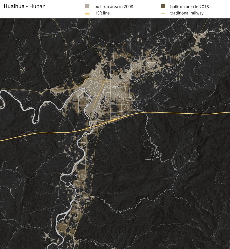
XVI EDIZIONE URBANPROMO "PROGETTI PER IL PAESE"
TORINO, NUVOLA LAVAZZA, 15 NOVEMBRE 2019

LA CITTÀ
CONTEMPORANEA:
UN GIGANTE DAI
PIEDI D’ARGILLA
Atti della conferenza internazionale
a cura di Michele Talia
CREDITI

                      LA CITTÀ CONTEMPORANEA: UN GIGANTE DAI PIEDI D’ARGILLA
    Atti della Conferenza internazionale, XVI edizione Urbanpromo "Progetti per il Paese"

                                                                     COMITATO SCIENTIFICO
Michele Talia (Presidente) | Angela Barbanente | Carlo Alberto Barbieri | Giuseppe De Luca
                  Patrizia Gabellini | Carlo Gasparrini | Paolo La Greca | Roberto Mascarucci
       Francesco Domenico Moccia | Federico Oliva | Pierluigi Properzi | Francesco Rossi
                                              Iginio Rossi | Stefano Stanghellini | Silvia Viviani

                                                 COORDINAMENTO TECNICO SCIENTIFICO
           Rosalba D’Onofrio | Giulia Fini | Carolina Giaimo | Laura Pogliani | Marichela Sepe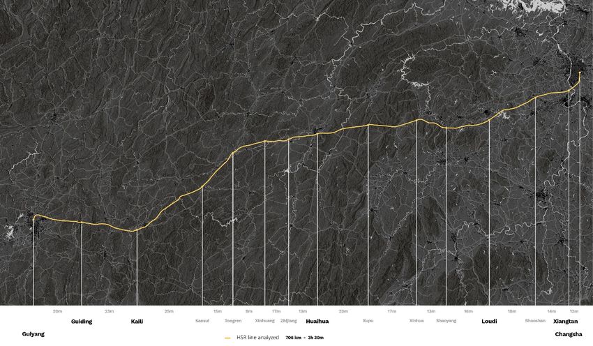
INDICE

INTRODUZIONE                                      studies an irreconcilable conflict or an
  Michele Talia				                      p. 9     opportunity for Western academics?
                                                    Francesca Blanc, Antonio di Campli, Andrea
                                                    Mora, Maurizio Pioletti 		               55
CONTRIBUTI
Percorsi di resilienza in Italia e Spagna.        La ricerca dell’effetto urbano
Fenomeni insediativi contemporanei e nuovi          Antonio Bocca 			                         62
modelli di mobilità
  Chiara Amato, Mario Cerasoli, José Maria de     Infrastrutture verdi e blu: l’approccio
  Ureña, Chiara Ravagnan 		                 15    transcalare del progetto europeo LOS_DAMA!
                                                     Sarah Braccio, Federica Marchetti, Maria
Da una 'quinta urbana' statica ad un ambito          Quarta 				                              67
collettivo dinamico: la trasformazione di uno
spazio urbano                                     Campagna e città: un dualismo da ritrovare
  Roberta Angelini 			                     22     per rigenerare gli ambienti urbani e far fronte
                                                  all’emergenza alimentare
La pianificazione urbanistica nella Città            Giovanni Bruschi, Daniele Amadio          72
Metropolitana di Napoli come strategia di
adattamento ai cambiamenti climatici: due         Riuso, co-living e nuove pratiche urbane
esperienze                                          Francesca Calace, Giuseppe Resta          77
  Antonia Arena 			                       30
                                                  Percorsi urbanistici innovativi e condivisi per
Quale rigenerazione?                              città che si adattano al Climate Change
  Francesca Assennato, Michele Munafò       35       Chiara Camaioni, Rosalba D’Onofrio       85

Re(in)cludo. Il carcere come luogo di             Autorganizzazione comunitaria, produzione
accoglienza nella città                           dei beni comuni e rigenerazione della
  Antonella Barbato 			                    41     democrazia
                                                    Giuseppe Caridi 			                   91
Quali strumenti per l’uso sostenibile del
suolo? Un’indagine tipologica nel contesto        The rearticulation of urban processes
europeo                                           within China’s HSR small cities: empirical
  Erblin Berisha, Donato Casavola, Giancarlo      observations through data-informed
  Cotella, Umberto Janin Rivolin, Alys Solly 47   diachronic maps
                                                    Francesco Carota , Valeria Federighi, Matteo
Is the decolonial approach in spatial planning      Migliaccio 			                          96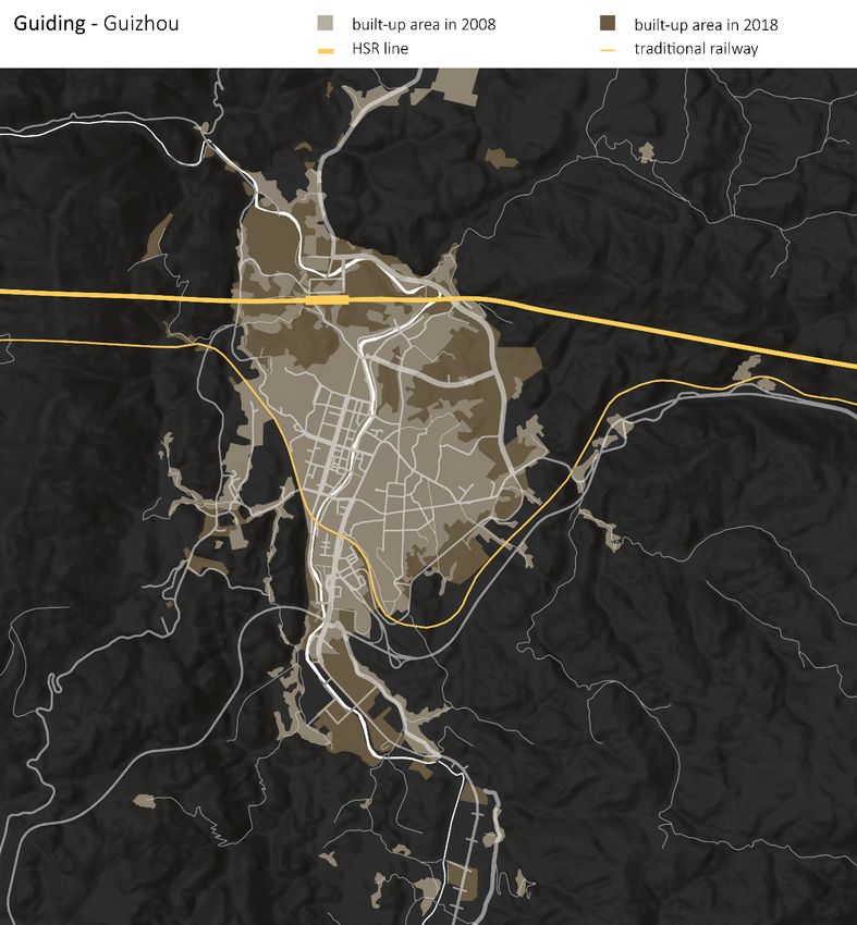
La città del Terrestre. L’architettura come          Curcuruto 				                            157
fonte di innovazione del conflitto locale/
globale                                            Piani di Mitigazione e di Adattamento
  Francesco Casalbordino 		                114     congiunti per affrontare il cambiamento
                                                   climatico sulla costa adriatica: Il progetto
Prospettive di riorganizzazione del                Joint_SECAP
commercio (modi, luoghi e tempi del                   Rosalba D’Onofrio, Stefano Magaudda,
consumo) come possibili fattori di                    Stefano Mugnoz, Elio Trusiani           169
rivalutazione delle aree centrali delle “piccole
metropoli”                                         Nuove tecnologie per affrontare la sfida dei
   Aldo Cilli 				                          119    cambiamenti climatici, promuovere la salute
                                                   urbana, la coesione sociale e l'equità
The cycle network as a soil project for urban        Rosalba D’Onofrio, Elio Trusiani       176
resilience
  Antonio Alberto Clemente 		              126     Smart City e Smart People: dalla realtà
                                                   urbana alla realtà mista
Verso un paradigma qualitativo per                   Michele De Chiaro, Gabriele Garnero       182
affrontare consumo di suolo e vocazioni
funzionali nella Città Metropolitana di Torino     Una urbanistica sperimentale per una
  Federica Corrado, Luca Lazzarini, Giulio         società post-urbana
  Gabriele Pantaloni, Carolina Giaimo      134       Donato Di Ludovico, Pierluigi Properzi    189

Dall’occupazione abusiva alla legittimazione       A GIS analysis reconstructing the
a fini abitativi. Il caso de la Salette a Torino   regeneration programme of the Liberta
   Valeria Cottino, Veronica Gai, Annalisa         neighbourhood of Bari
   Mosetto, Maurizio Pioletti, Paola Sacco 143       Gabriele Di Palma 			               196

Rigenerazione urbana e città pubblica. Il          Service Design. Un servizio per la comunità
Contributo Straordinario di Urbanizzazione           Francesca Filippi, Elisabetta Benelli  205
nelle leggi regionali
  Francesco Crupi 			                     151      Una partenza in salita. I primi cinque anni
                                                   della Città metropolitana di Torino
La riforma portuale e le innovazioni nella           Gianfranco Fiora, Carolina Giaimo         210
pianificazione: il caso di Bari
  Serena D’Amora, Alessandra Saponieri,            Indirizzi interpretativi e progettuali fondati
  Francesco Di Leverano, Anna Maria                su un’ontologia delle relazioni per creare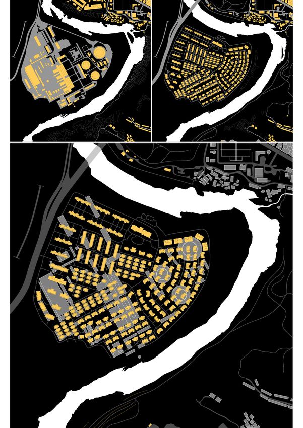
reti di città e di infrastrutture sostenibili,       città ai cambiamenti climatici: computational
alternative alle concentrazioni ipertrofiche         masterplanning
delle agglomerazioni urbane contemporanee               Lorenzo Massimiano, Andrea Galli     263
   Marco Fregatti 			                          216
                                                     La Città metropolitana di Torino e la sua
Le azioni di depaving dei suoli urbani per           dimensione metropolitana: una questione
una nuova multifunzionalità degli spazi              aperta
sottoutilizzati                                        Irene Mortari, Giannicola Marengo, Stefania
  Emanuele Garda 			                       225         Grasso 				                             268

Le centralità urbane come strumento di ri-           La riconversione dell’ex area industriale di
composizione di Bellaria Igea Marina                 Crotone. Verso una pianificazione integrata e
  Cristian Gori 				                    232          sostenibile
                                                       Domenico Passarelli 			                  275
Le sfide contemporanee nella nuova
pianificazione territoriale della Città              Sviluppo sostenibile per la Città
metropolitana di Torino                              Metropolitana di Reggio Calabria. Hub
  Stefania Grasso, Irene Mortari, Giannicola         metropolitani-cerniere territoriali
  Marengo 				                             238         Domenico Passarelli, Federica Suraci,
                                                       Francesco Suraci 			                    280
Walking like needles in the city. Sewing new
activities                                           Il recupero delle cave dismesse: da vuoti di
  Tiziano Innocenzi 			                   244        paesaggio a spazi di aggregazione
                                                         Elena Paudice 			                     284
S.O.S. Catania: Soluzioni Occasionali per
Senzatetto a Catania. Strategie e soluzioni          La sfida del consumo di suolo a saldo zero: le
volte a migliorare la qualità della vita dei         azioni di rigenerazione urbana delle regioni
senzatetto in ambito urbano a Catania                italiane
  Gaetano Giovanni Daniele Manuele           248        Piera Pellegrino 			                   290

Gli Investimenti Territoriali Integrati in ambito    From unplanned to planned urban
urbano. L’esperienza della Sardegna                  settlements. Housing solutions for
   Gavino Mariotti, Maria Veronica Camerada,         environmentally-friendly cities in developing
   Salvatore Lampreu 			                    257      countries
                                                       Viola Angela Polesello 		               298
Processi innovativi per l’adattamento delle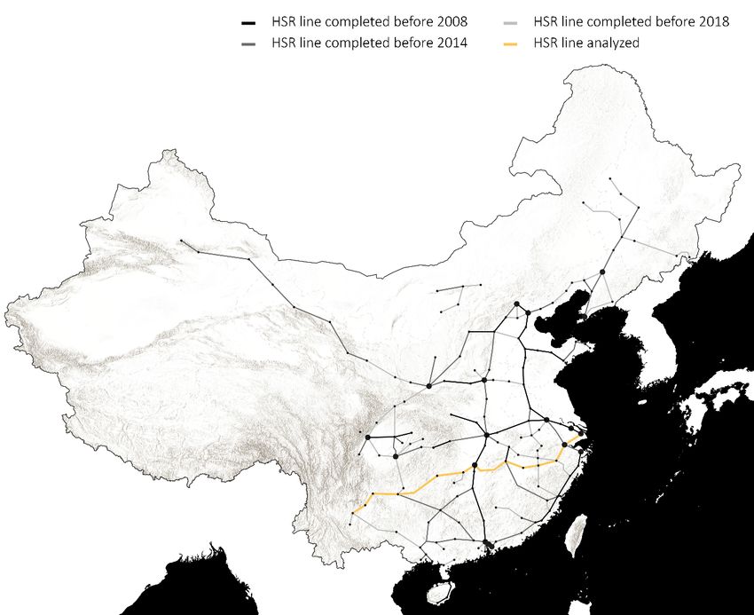
Il ruolo delle green infrastructure nella         di urbanizzazione delle aree costiere
costruzione di strategie adattive resilienti      metropolitane. Roma, la permanente
    Irene Poli, Silvia Uras 		            310     oscillazione tra mare e territorio interno
                                                     Saverio Santangelo, Maria Teresa Cutrì,
Il ‘Mio Capitale Verde’: investire in                Nicole del Re 			                       361
conoscenza e nell’ambiente
    Veronica Polin, Lisa Lanzoni 		       318     Trenta città medie: nuove categorie di
                                                  interpretazione della conurbazione di Rimini
Il benessere attraverso/a la città                   Scarale Annalisa 			                  367
    Chiara Pompei 			                     326
                                                  Le ‘figure alpino-metropolitane’
La sfida del cambiamento climatico come             Roberto Sega 			                            372
opportunità per rafforzare la resilienza delle
città in cammino verso la sostenibilità.          Forme urbane che cambiano: la urban
Strategie, strumenti, sperimentazioni             network analysis come strumento per
   Gabriella Pultrone 			                  332    rintracciare nuove tecniche di pianificazione
                                                  spaziale
Are privately owned public spaces effective          Maria Somma 			                        384
design and planning tools that can favour
the creation of healthy, public spaces            Promuovere il Transit Oriented Development
in contemporary cities? Notes from an             in Italia: il ruolo della pianificazione di livello
empirical study in New York.                      metropolitano
   Antonella Radicchi 			               340          Luca Staricco, Elisabetta Vitale Brovarone 390

Spazio pubblico e rigenerazione urbana. Gli       La valorizzazione dell’antica Kroton mediante
strumenti operativi per un nuovo welfare          la programmazione strategica. Interventi
  Laura Ricci, Francesco Crupi, Iacomoni          integrati e nuova governance
  Andrea 				                            347         Ferdinando Verardi 			                401

Rigenerazione urbana e riequilibrio               Salubrità degli ambienti urbani mediterranei.
territoriale. Per una politica integrata di       Strategie progettuali bioclimatiche ed
programmazione e di produzione di servizi         energie rinnovabili
  Laura Ricci, Francesca Rossi, Giulia              Ferdinando Verardi, Domenico Passarelli,
  Bevilacqua 				                           354     Ivana Carbone 			                        407

La componente turismo e loisir nei processi       INDICE DEGLI AUTORI                           414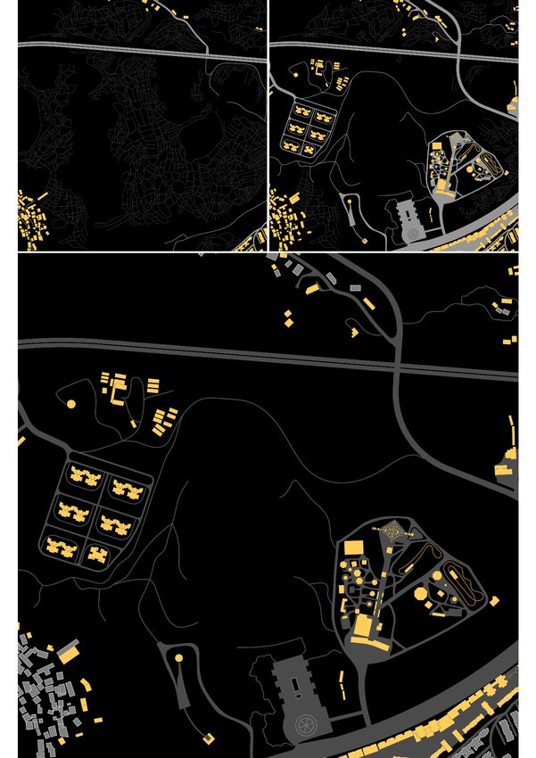
The rearticulation of urban processes within
         China’s HSR small cities: empirical observations through
                     data-informed diachronic maps

                                                   Francesco Carota
                                               Politecnico di Torino
                                      DAD – Dipartimento di Architettura e Design
                                            Email: francesco.carota@polito.it

                                                   Valeria Federighi
                                               Politecnico di Torino
                                      DAD – Dipartimento di Architettura e Design
                                            Email: valeria.federighi@polito.it

                                                  Matteo Migliaccio
                                               Politecnico di Torino
                                      DAD – Dipartimento di Architettura e Design
                                            Email: matteo.migliaccio@polito.it

Abstract
This paper looks to the transformations that are currently underway in those Chinese territories that are identifiable as
“small cities” (Gu, Li, Han 2015), and which for a long time were excluded from the dramatic spatial and demographic
expansion of China’s major mega-city regions. Particularly, we focus on the small and medium-sized towns that are
situated along major transportation corridors, promoted in the frame of a large scale High Speed Railways
infrastructural plan, which in only one decade connected densely urbanized areas and interstitial territories. The
importance that small cities in China have recently acquired is part of a precise political development plan that aims at
reducing internal demographic and social inequalities and redistributing the urban population from first and second
level cities to smaller ones. There has been subsequent increase in the academic interest on urban growth in these small
Chinese cities, which in many cases still reveal a complex "urban-rural binary" (Kendall, 2015). However, many of
these studies have focused on highlighting the tensions and contradictions in terms of social and economic
restructuring, while the forms and features of these urbanization processes—particularly in terms of spatial
transformations—have certainly received less attention. The analysis of this latter aspect therefore represents the main
objective of this contribution.

Parole chiave: infrastructures, rural areas, maps

1 | Introduction
Starting from a wide georeferenced database of Chinese High Speed Railway (hereafter HSR) stations and
new urban settlements developing with and around them1, this paper focuses on small towns located in
China’s interior geographical areas. Until about ten years ago, small towns of the interior had remained
outside the strategic national developmental interests of the country; in recent years they have started to
appear in governmental plans and are now invested by a round of strong urbanization processes.
During the last four decades, China has been characterized by a fast-paced urbanization (Wu et al., 2016);
according to official statistics, in 2014 the 54.77% of its population could be considered as urban (Zhang,
Han, 2009). Although this is still a relatively low figure compared to the average of both developed and
developing countries (Chen, Zeng, Xie, 2000), it shows a growing trend as a direct consequence of a number
of institutional measures.
Many actions have been carried out by China’s central government in order to further increase the amount
of urban population in the country, many of which were additionally confirmed into the National New
Urbanization Plan (2014-2020) released in 2014, which envisaged China's urbanization level to reach at least

1See the paragraph on methodology, “research design,” for an extensive explanation of the way the database is structured and the
use we make of it.

                                                              96
60% in 2020 - meaning that about 100 Million rural population [would] become new urban residents (Zhang,
Han, 2009) - and at least 70% in 2025 (Johnson 2013).
In order to reduce the pressure on increasingly overcrowded large cities around which growth has long been
centered in a context of accelerating urbanization (Qian, 2017), these political and strategic projects aim at
integrating and resettling the rural population into small towns and medium-sized cities.2 More precisely,
both the 12th and 13th national Five Year Plans, drafted respectively in 2011 and 2016, have radically
changed some of the country’s main lines of development, by including «small towns located in central areas
as part of the ‘locomotives’ of the country's economic growth and destinations for both investors and
migrants» (Qian, 2017: 33). In this context, the term “cheng shi hua” (urbanization or population shift to
cities) was thus replaced by the term “cheng zheng hua” (population shift to cities and towns) (Wang, 2012).
In terms of spatial and territorial planning, the critical role of small towns in the regional context was
promoted by the National Urban and Rural Planning Act, which «revised the traditional city-centered
planning strategies and included small towns and rural areas in the formal master planning mechanism,
emphasizing the concept of city-region as a spatial context for planning» (Qian & Xue, 2017: 152).
However, all those plans were also fostered and strongly supported by a new steadfast infrastructural plan
that envisaged the development of a colossal HSR network as one of its key points. In this respect, on April
18, 2007, the CRH (China Railway High-speed) was launched for the first time in China. This new
transportation route marked a breakthrough development, not only in terms of technological transfer, but
also in terms of social and economic effects. In less than 10 years of development, HSR lines massively
spread into the whole country [Figure 1], thus connecting many of those places which were previously
considered marginal and have now been designated as strategic centers of China's internal development
(Qian, 2017).
2 Following Kendall (2015), this classification of “small city” is based on a “sophisticated” five-tier hierarchy that is based on
«considerations of administrative ranking, representational power, city dynamism and citizens’ self-identification» (idem: 665) In
this administrative hierarchy, the threshold between small towns and medium-sized cities is 500.000 inhabitants.
97© Matteo Migliaccio
Figure 1 | Overall view of China’s HSR network development between 2008 and 2018
Fonte: Elaboration by Matteo Migliaccio based on China Railway High-speed (CRH) official map –
online edition - january 2019.
During the last four decades, a huge amount of literature on urban China focused on the previously unseen
urbanization of big coastal cities (Particularly the so named first and second tiers cities), stressing its striking
numbers (Anderson, Ge, 2005; Zheng, Saiz, 2016), its quality (Zheng, Fu, Liu, 2008; Zhou et al., 2015), its
social effects in terms of accessibility (Li, et al., 2015), inequality (Li 2012) and environmental sustainability
(Fleisher, 2015). More recently, authors have started to look at rural China and its relationship with small
but expanding urban centers, directing their attention to the institutional structures and changes of these
settlements (Kendall, 2015), their economic or their social restructuring in terms of accessibility (Lin, 2003;
Ma, 2002), inequality (Qian, 2017) and changes in migration waves (Zhang, Han, 2009). Less is known about
the physical transformation of small cities, the form and the speed of their urbanization, as well as about
their relations to the infrastructure that is intensifying or at least supporting this change. Further, we observe
that many studies (Wang, Gu, 2019; Zheng et al., 2016) employ quantitative methodologies to demonstrate
the reach of the HSR phenomenon on interior areas in China, employing a macro-scale level of analysis that
allows to comparatively assess the impact of infrastructuring processes – but not their form; conversely, we
propose to employ qualitative methods of observation, relying on diachronic mapping at different scales, to
observe actual spatial transformations that are occurring in the specific places we analyse, thus aiming at
displaying different types of cause-and-effect relationship occurring between infrastructure and urban
growth.
Starting from the observation that HSR infrastructuration is having a prominent role in driving and boosting
a socio-economic restructuring of urban environments (also described in terms of “urban vibrancy” (Zheng
et al., 2016), we ask whether this restructuring has identifiable spatial characteristics in the case of small
towns; further, we ask what the most effective way is, to examine and measure such spatial characteristics
in terms of dimensions of built-up area, direction and expansion of its growth, and change in its
98morphological structure. In this way, we set out to observe actual instances of spatial transformation – for
instance, from rural grid to urban infrastructure and objects, from villages to housing estates, and so on.
Finally, we aim at showing that, even though it is possible to identify comparable patterns of growth when
small towns are reached by HSR, each settlement features its own specific dynamics of urbanization, and
that a close observation of those specific dynamics allows to assess the role of other factors concurring to
the process of spatial restructuring, thus avoiding a deterministic view of the relationship between HSR and
urban growth.
The rest of the paper is organized as follows. First, we provide a methodological understanding of our work,
particularly focusing on the design of our research - and showing the relationship between observed objects
and scale/method of observation. In the central part of the paper, we work with three methods of
representation at two scales of analysis, each attempting to unpack one specific aspect of the working
hypothesis. Finally, some concluding remarks are provided.
2 | Research Design
This paper is the result of a collaboration between Politecnico di Torino and Massachusetts Institute of
Technology and builds on an ongoing research carried out by the China Future City Lab at MIT around the
correlation between infrastructuralization and urban vibrancy in China. The research consists in the
construction of a database allowing to evaluate the vibrancy of cities that have grown around HSR stations.3
In this perspective, HSR stations are inferred to be one of the main drivers of the “new town” (Bonino et
al., 2019) urbanization surrounding them, as such urbanization exists in such form as a direct consequence
of the construction of HSR stations, and – more broadly – of the political intention of urban expansion
which the construction of these stations is a part of.
In order to reflect on the relationship of cause and effect between HSR infrastructuring and urban growth,
we focus on cities of smaller size of the interior, where the changes brought by the building of an HSR
connection can be observed more easily. Therefore, from the 261 cities of the initial database we select
those having around 500.000 inhabitants - identified as the threshold between “small cities and towns” and
“medium-sized cities” according to the Chinese ranking of cities by size (Gu, Li, Han, 2015: 114), leaving
us with 29 new small/medium cities and towns. This result allows us to identify a section of an HSR line
that has the most presence of small and medium new towns responding to the criteria employed, namely
the HSR line connecting Guiyang and Changsha, within the Shanghai-Kunming line, which is highly
representative of governmental “go-west” policies (Sun, 2016) attempting to shift the pressure of
urbanisation from coastal cities to the interior. This East-West line constructs a link between two very
distant and different regions: on the one hand the east coast, the most historically developed area; on the
opposite side, one of the least integrated regions in national development plans, Yunnan, with its capital
Kunming. This infrastructural axis connects places that up to a decade ago were considered part of "rural
China" and were characterized by the preeminence of villages and "small towns” (Han, 2010). Within this
wider line, we select a portion connecting the capital of Hunan province and the capital of Guizhou
province, Changsha - Guiyang [Figure 2]. Along this section of the line, the four towns of Guiding, Kaili,
Huaihua and Loudi answer to the criteria employed in our study. To these, we add the town of Xiantang,
a slightly larger medium-sized city of around 1 million inhabitants, which has two HSR stations along two
different lines, allowing us to observe a clear vectorial growth in two directions; and Liupanshui as a case of
similarly-sized town in which no HSR station was built, but similar patterns of growth can nonetheless be
observed.
3Siqi Zheng, Carlo Ratti, Lei Dong, Rui Du, Matthew Kahn, “Can High-speed Rail Station Support a New Town? Empirical
Evidence from China,” in progress.
99© Matteo Migliaccio
Figure 2 | Territorial view of HSR cities with station in the Changsha - Guiyang line
Fonte: Elaboration of cartographic data by Matteo Migliaccio.
In observing these towns, we focus on the urbanization process and the investigation of changes during
time, we employ different kinds of diachronic mapping of these cities and of their pattern of growth
(footprint of built-up area, direction of growth, changes in urban texture). The following cartographic and
diagrammatic representations are produced using OpenStreetMap, EOC Geoservice, Axismaps, ArchGis,
as well as Google Earth historical datasets, from which we retrieved the boundaries of built-up areas and its
morphology in two significant moments in time: 2008, when the Ministry of Railway announced the HSR
plan (Huang et al., 2018), and 2018 as the most recent available dataset – thus showing the furthest possible
stage of development in terms spatial transformations.
Starting from a comparative study of selected cities, we move to a closer observation of the urban
morphology of Kaili as a way to observe these changes at a closer scale. In total, two main scales and three
methods of observation were adopted in order to multiply the narratives and perspectives and create a
tension between different representations of changes. We assume that different scales and methods of
observation allow us to verify different hypotheses and to draw on different and even overlapping results.
Table 1 synthesizes the different steps of the research, displaying per each of those, the general objectives,
approaches and observations that could be retrieved.
In doing this exploratory work, we aim at providing a small contribution to the way rural to urban China’s
binary is understood, by investigating both qualitatively and quantitatively the impact of a large infrastructure
(the HSR line) on the urban growth of small cities, and the corresponding spatial restructuring.
100Table I | Indication of maps at different scales in relation to hypothesis, variables and results of the research.
1013 | Mapping the spatial configuration of HSR Chinese small towns
© Matteo Migliaccio
Figure 3 | Diachronic map of Guiding built-up area growth between 2008 and 2018
Fonte: Elaboration of cartographic data by Matteo Migliaccio.
102© Matteo Migliaccio
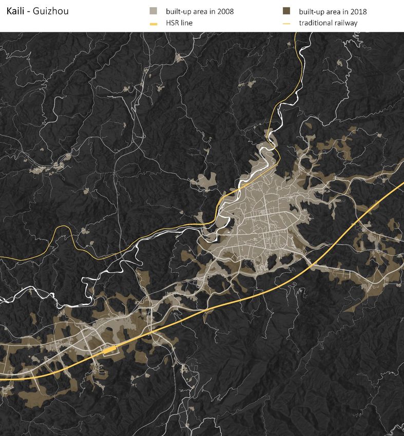
Figure 4 | Diachronic map of Kaili built-up area growth between 2008 and 2018
Fonte: Elaboration of cartographic data by Matteo Migliaccio.
103© Matteo Migliaccio
Figure 5 | Diachronic map of Huaihua built-up area growth between 2008 and 2018
Fonte: Elaboration of cartographic data by Matteo Migliaccio.
104© Matteo Migliaccio
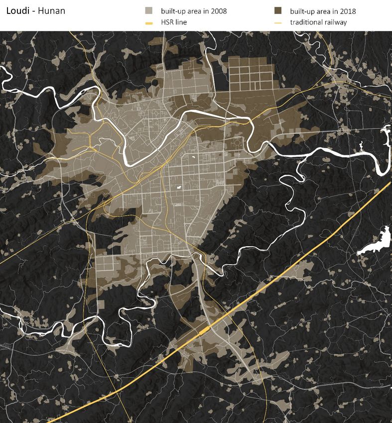
Figure 6 | Diachronic map of Loudi built-up area growth between 2008 and 2018
Fonte: Elaboration of cartographic data by Matteo Migliaccio.
105© Matteo Migliaccio
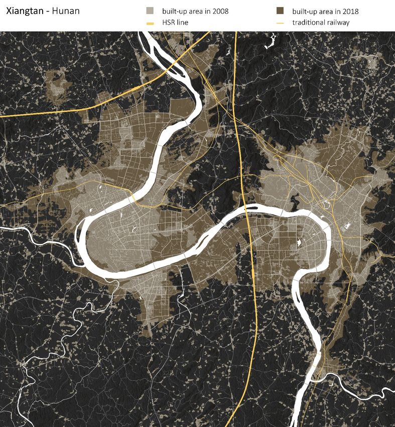
Figure 7 | Diachronic map of Xiangtan built-up area growth between 2008 and 2018
Fonte: Elaboration of cartographic data by Matteo Migliaccio.
The five maps [Figures 3-7] focus on three main elements: extensions of built-up area, orographic conditions
of the territory and main infrastructural lines (major roads and railway lines). This simplification of a
complex space-territory allows to isolate the city’s expansion in terms of built-up area as a result of - among
possibly other less impacting factors - the introduction of HSR infrastructuring within specific orographic
and infrastructural pre-existing conditions. This factor is also quantitatively confirmed in the following steps
of the research.
Looking comparatively at the five maps, we can observe some common traits among them - namely, the
location of the HSR stations and the directions of urban growth are convergent; as well as some notable
differences - in some cases (e.g. Kaili and Xiangtan) there is one clear main direction of growth overlapping
with the position of the station, while in others (e.g. Huaihua and Loudi) the pattern of growth is more
diversified, hinting at a more complex infrastructural and orographic system. In order to measure the
significance of such categories with respect to the presence of HSR infrastructure, in the following section
106we rely on the adoption of quantitative diagrams that allow us to compare the five HSR towns with five
non-HSR towns located in the same area and featuring comparable size.
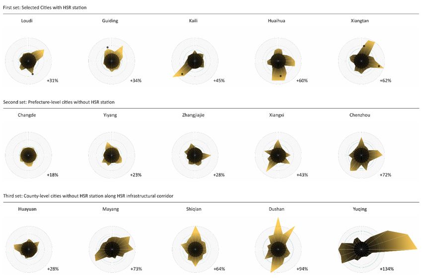
Figure 8 | Schematic representation/quantitative measure of built-up area growth in 5 HSR Towns and
5 non-HSR Towns between 2008 and 2018
Fonte: Elaboration of cartographic data by Matteo Migliaccio.
This second visualization method [Figure 8] provides an abstract representation of some selected towns and
their growth during time. These schematic representations are elaborated as follows: a first circle represents
a normalization of built area in 2008. All the other concentric circles indicate percentages of growth (10%
per each circle). Thus, having set the reference system, the direction and amount of growth between 2008
and 2018 is indicated as a yellow bounded area. The aim of this analytical device is to provide quantitative
measures of growth in three sets of towns along the chosen infrastructural line. The first two sets are
comparable in terms of original (pre-infrastructuralization) size: one set of five towns that have an HSR
station, and a set of towns that do not. This latter set is made of 16 Prefecture-level cities (thus, indicatively,
cities between 500.000 and 1m inhabitants) across Hunan and Guizhou, of which we chose to represent the
two cities with the lowest percentage of growth (Changde and Yiyang), the two cities with the highest
percentage of growth (Xiangxi and Chenzhou), and the city with closest to a weighted average percentage
of growth (Zhangjiajie). The third set shows five County-level cities (below 500.000 inhabitants) dislocated
along the HSR infrastructural corridor.
Looking at the first set, it is immediately possible to verify that the location of the HSR station is one of the
main factors – if not the main factor – influencing the direction of growth within towns. In many of these
cases, the building of the station coincides with the development of a new town. Non-HSR towns of similar
dimensions (second set), on the other hand, feature a much less polarized direction of built-up area
expansion. In this case the direction of growth is influenced by a broader set of elements, such as
infrastructural corridors (roads, railways), topography and existing settlements. Also, it is possible to see that
the average growth of non-HSR towns (second set) is quite lower than that of HSR towns (first set).
Somewhat counterintuitively, though, the diagrams of the third set show that smaller non-HSR towns along
the infrastructural line grow even more sensibly than the HSR towns of the first set. Although this data is
biased by the different dimensions of the towns in the two sets, it may point toward the possibility that the
effects of the infrastructure exceed the single urban agglomeration. For all these reasons, the HSR line
107cannot a priori be considered the main driver for the development of a small town, but rather its role as one
of the multiple and overlapping factors influencing their growth in terms of built-up area is to be assessed
case by case; or, conversely, we can assume that the type of transformation occurring as a result of HSR
infrastruring cannot be described as merely – or only – quantitative (an expansion of built-up area), but also
as qualitative (substitution of one type of texture with another). Clearly, this type of transformation cannot
be observed at this scale of analysis, which does not provide any further information on the nature of the
built environment, its structures, as well as its morphology and land use. All these factors, which are worth
of investigation in order to better comprehend the development dynamics of China’s small towns, are
observed in the following section of the paper adopting a different method and scale of representation.
108© Matteo Migliaccio © Matteo Migliaccio
© Matteo Migliaccio
Figure 9 | Morphological changes in Kaili built-up area between 2011 and 2018
Fonte: Elaboration of cartographic data by Matteo Migliaccio.
109© Matteo Migliaccio © Matteo Migliaccio
© Matteo Migliaccio
Figure 10 | Morphological changes in Kaili built-up area between 2011 and 2018
Fonte: Elaboration of cartographic data by Matteo Migliaccio.
110The third and last type of maps is based on specific portions of the built environment in the town of Kaili.
More precisely, we select plots of land of 1 square km, a dimension that allows us to investigate the built
environment at an urban scale. The single portions are selected along the axis that connect the new HSR
station to the existing city center, as those most representative of a type of transformation that points to
social, economic, environmental and cultural changes, and to a distinction between rural and urban
categories that is still in need of redefinition. We refer to Kendall (2015) for an articulation of this issue on
the specific case of Kaili, drawing on a wider debate around the need to unpack the “metanarrative” of the
urban (Brenner, 2016), the “ordinariness” of urban agglomerations (Robinson, 2006) and the “planetary”
scale of urbanisation (Merrifield, 2011; Brenner, Schmid, 2014).
Specifically, two selected areas were mapped diachronically to show the change in texture. The first map
[Figure 9] highlights the transition from an industrial site to a middle-class housing estate. New residential
settlements such as this one pursue and promote a very specific idea of urban life, shaped around those
housing models that firstly appeared within first and second-tier cities during the previous period of
economic and housing reforms (Zhang, 2010). This transformation can be connected to the location of the
site (riverside), as well as to a «nationwide shift away from industrialism» (Kendall, 2015: 668) that translates
into specific substitutions of urban texture that are most visible in areas close to the town center such as
this one, whereas low-density productive and service areas move outwards.
The second map [Figure 10] shows a portion of land closer to the HSR station, where a rural settlement
composed of villages and agricultural grids gives way to new infrastructural connections, newly built
residential complexes and an amusement park. This again suggests a radical spatial transformation that can
be easily connected to a broader socio-economic change occurring in the frame of rural restructuring
phenomena (Hoggart, Paniagua, 2001); As Qian (2017) describes it, «there are two main phases in a
transition from village life to urban life: the first involved the population status change and physical form
transformation, and the second, which is more fundamental, entails changes in former villagers’ values,
ideology, culture, perception, behaviour, employment, lifestyle, mindset, etc.» (idem: 35).
Although these two maps cannot nearly provide an exhaustive picture of a similar change, they can
nonetheless point towards a possible way to observe these changes which has been up to now overlooked.
4 | Concluding remarks
The main results of this exploratory research can be summarized as follows: it is possible to show that the
introduction of HSR stations has contributed to the growth of small-and-medium towns of the interior as
part of a political plan of development. Nonetheless, it is also possible to show that HSR stations are not
the only driver of development – as many towns that do not have an HSR station show a similar order of
growth. For this reason, it is necessary to carry out a qualitative observation of the transformations, by
zooming in and looking at the specific changes in urban texture. In this way, it is possible to observe that
the section of the town connecting the station to the previously existing urban center is the section of the
town that offers the most significant types of substitutions, as for instance from heavy industry to dense
urban housing, or from agricultural grids to amusement park. Although we do not yet have sufficient data
to draw falsifiable conclusions from this last scale of observation, it nonetheless seems indicative of the fact
that closer and more qualitative analyses are needed in order to fully understand this complex but extremely
rapid reshuffling of the "urban-rural binary" (Kendall, 2015) in China’s small towns .
References
Anderson G., Ge Y. (2005), “The size distribution of Chinese cities” in Regional Science and Urban Economics,
no. 6, vol. 35, pp. 756–776.
Blecher M. (2008), “Into space” in City, no. 2, vol. 12, pp. 171-182.
Bonino M. et al. (2019), The City after Chinese New Towns: Spaces and Imaginaries from Contemporary Urban China,
Birkhäuser Verlag GmbH, Basel.
Brenner N. (2016), “The Hinterland, Urbanized?” in AD / Architectural Design, July/August, pp. 118-127.
Brenner N. (2017), Critique of Urbanization: Selected Essays, Birkhäuser Verlag GmbH, Basel.
Brenner N., Schmid C. (2014), “The ‘Urban Age’ in Question” in International Journal of Urban and Regional
Research, no. 3, vol. 38, pp. 731–755.
Chen S., Zeng S., Xie C. (2000), “Remote Sensing and GIs for Urban Growth Analysis in China” in
Photogrammetric Engineering and Remote Sensing. no. 5, vol. 66, pp. 593-598.
Fleisher B. M. (2015), “Urbanization in China” in China Economic Review, vol. 35, p. 219.
111Fløysand F., Jakobsen S. E. (2007), “Commodification of Rural Places: A Narrative of Social Fields, Rural
Development, and Football” in Journal of Rural Studies, no. 2, vol. 23, pp. 206-221.
Gu C., Li Y., Han S. S. (2015), “Development and transition of small towns in rural China” in
Habitat International, vol. 50, pp. 110-119.
Han S. S. (2010), “Urban expansion in contemporary China: What can we learn from a small town?” in Land
Use Policy, no. 3, vol. 27, pp. 780-787.
Hoggart K., Paniagua A. (2001), “What rural restructuring?” in Journal of Rural Studies, no. 1, vol. 17, pp. 41–
62.
Huang Y. et al. (2018), “Exploring Railway Network Dynamics in China from 2008 to 2017” in ISPRS
International Journal of Geo-Information, no. 8, vol. 7, p. 320.
Immers B., Egeter B., Van Nes R. (2004), “Transport network planning: theoretical notions” in Kutz M
(ed.), Handbook of Transport Engineering, McGraw-Hill, New York, pp. 2.1-2.33.
Kendall P. (2015), “Between big city and authentic village” in City, n. 5, vol. 19, pp. 665–680.
Kirby R. J. R. (1985), Urbanisation in China: Town and country in a developing economy 1949-2000 AD, Croom
Helm, London.
Li H. et al. (2015), “Residential clustering and spatial access to public services in Shanghai” in Habitat
International, vol. 46, pp. 119–129.
Li S (2012), “Housing Inequalities under Market Deepening: the Case of Guangzhou, China.” in Environment
and Planning A, no. 12, vol. 44, pp. 2852-2866.
Lin G. C. S. (2003), “Changing discourses in China geography: A narrative evaluation” in
Environment and Planning A, no. 10, vol. 34, pp.1809-1831.
Ma L. J. C. (2002), “Urban transformation in China, 1949-2000: A review and research agenda” in
Environment and Planning A, no. 10, vol. 34, pp. 1545-1569.
Mandal J., Ghosh N., Mukhopadhyay A. (2019), “Urban Growth Dynamics and Changing Land-Use Land-
Cover of Megacity Kolkata and Its Environs” in Journal of the Indian Society of Remote Sensing, no. 10, vol. 47,
pp. 1707-1725.
Merrifield A. (2011), “The Right to the City and beyond” in City, no. 3-4, vol. 15, pp. 473–481.
Naughton B. (1995), “Cities in the Chinese economic system: Changing roles and conditions for autonomy”
in Davis, D. et al. (ed.), Urban spaces in contemporary China, Cambridge University Press, New York, pp. 61-
89.
Qian Z. (2017), “Resettlement and adaptation in China's small town urbanization: Evidence from the
villagers' perspective” in Habitat International, vol. 67, pp. 33-43.
Qian Z., Xue J., (2017), “Small town urbanization in western China: villager resettlement and integration in
Xi’an” in Land Use Policy, vol. 68, pp. 152-159.
Robinson J. (2006), Ordinary Cities: Between Modernity and Development, Routledge, London.
Shen X., Ma L. J. C. (2005), “Privatization of rural industry and de facto urbanization from below in
southern Jiangsu, China” in Geoforum, no. 6, vol. 36, pp. 761-777.
Sun H. (2016), “Study on the correlation between the hierarchical urban system and high-speed railway
network planning in China” in Frontiers of Architectural Research, no. 3, vol. 5, pp. 301-318.
Van Nes R. (2002), Design of Multimodal Transport Networks: A Hierarchical Approach, DUP Science, Delft.
Wang L., Gu H. (2019), Studies on China’s High-Speed Rail New Town Planning and Development, Springer,
Singapore.
Wang Y. P. (2012), New Trend of Urbanization in China: Land and Housing Development in Suburban Areas and
Small Towns, Lincoln Institute of Land Policy, Cambridge and Massachusetts.
Wu Y. et al. (2016), “Urban growth dilemmas and solutions in China: Looking forward to 2030” in Habitat
International, vol. 56, pp. 42-51.
Zhang L. (2010), In Search of Paradise: Middle-Class Living in a Chinese Metropolis, Cornell University Press,
Ithaca.
Zhang L., Han S. S. (2009), “Regional disparities in China's urbanization: an examination of trends 1982-
2007” in International Development and Planning Review, no. 4, vol. 31, pp. 355 - 376.
Zheng S., Fu Y., Liu H. (2008), “Demand for Urban Quality of Living in China: Evolution in Compensating
Land-Rent and Wage-Rate Differentials” in The Journal of Real Estate Finance and Economics, no. 3, vol. 38,
pp. 194-213.
Zheng S., Saiz A. (2016), “Introduction to the special issue “China’s urbanization and housing market” in
Journal of Housing Economics, vol. 33, pp. 1–3.
112Zheng S., et al. (2016), “Subways near the Subway: Rail Transit and Neighbourhood Catering Businesses in
Beijing” in Transport Policy, vol. 51, pp. 81–92.
Zhou D., et al. (2015), “Assessing urbanization quality using structure and function analyses: A case study
of the urban agglomeration around Hangzhou Bay (UAHB), China” in Habitat International, vol. 49, pp.
165–176.
113LA CITTÀ
CONTEMPORANEA:
UN GIGANTE DAI
PIEDI D’ARGILLA
Per la prima volta dopo oltre due secoli l’innovazione tecnologica non sembra più in grado di
compensare con l’apertura di nuovi mercati la perdita di posti di lavoro determinata dall’aumento
della produttività. In virtù di questo inaridimento degli sbocchi professionali l’opinione pubblica
scorge nella globalizzazione e nei flussi demografici originati dalle aree più povere e conflittuali
del pianeta le cause fondamentali di un’inquietudine crescente, che si somma alla scoperta
della fragilità di un ecosistema sempre più minacciato dalle calamità naturali e dagli effetti
traumatici di un climate change che sta accelerando il suo passo.
Le caratteristiche inedite e allarmanti di questo scenario sollecitano la mobilitazione delle
competenze e dei saperi con cui elaborare un punto di vista originale e integrato sul tipo di
società che è possibile costruire intorno a una economia a bassa intensità di lavoro, e sui
mutamenti che questo nuovo paradigma è destinato a introdurre al fine di ricondurre entro gli
strumenti della gestione urbana tanto le istanze del cambiamento, quanto le esigenze di tutela
dai rischi ambientali.
Gli Atti della conferenza internazionale per la XVI edizione di Urbanpromo "Progetti per il Paese"
raccolgono la riflessione di studiosi e ricercatori sulle nuove fragilità urbane.
Planum Publisher
www.planum.net
9 788899 237226Puoi anche leggere