TORINO CITTA' UNIVERSITARIA TORINO UNIVERSITY CITY
←
→
Trascrizione del contenuto della pagina
Se il tuo browser non visualizza correttamente la pagina, ti preghiamo di leggere il contenuto della pagina quaggiù

TORINO
       CITTA’
UNIVERSITARIA
      TORINO
  UNIVERSITY
         CITY

       Urban Center Metropolitano
        Piazza Palazzo di Citta’ 8/f
                     10122 Torino
            www.urbancenter.to.it

                       March 2013
INDICE
 INDEX

         00 | PREMESSA
              00 | INTRODUCTION

         01 | SETTE DISTRETTI, SETTE GEOGRAFIE
              01 | SEVEN DISTRICTS, SEVEN GEOGRAPHIES

         02 | LAYERS
              02 | LAYERS

         03 | RESIDENZE UNIVERSITARIE. NUOVE PROPOSTE
              03 | UNIVERSITY HALLS OF RESIDENCE. NEW PROPOSALS

2
00

Per lungo tempo, durante il ‘900, i luoghi dedicati alla residenzialità degli studenti universitari sono stati         PREMESSA
pensati quasi come uno spazio di natura extraterritoriale, sebbene il più delle volte inseriti nel tessuto         INTRODUCTION
della città. Questa concezione nasce da una molteplicità di fattori. Indubbiamente dall’applicazione
dei princìpi del modernismo architettonico e urbanistico: la residenza universitaria, e i servizi connessi,
devono essere luoghi specializzati disgiunti dall’ambiente urbano e devono rispondere a standard e
parametri quantitativi minimi (la superficie delle stanze per ospite, la presenza di servizi igienici pro-
capite ecc). Fino alle proteste studentesche degli anni ’60 e ’70 questo concetto è voluto e desiderato
dagli studenti stessi.
Da allora molte cose sono cambiate. Soprattutto a Torino. E’ cambiata profondamente la concezione
del rapporto tra luoghi dell’università e spazi urbani. Alla separazione si è sostituita l’idea dell’intreccio,
e indubbiamente le università e i suoi luoghi sono diventati uno dei principali motori dello sviluppo
urbano e della qualità delle città. Inoltre Torino si è trasformata in anni recenti in una città universitaria
di primissimo livello, con Atenei come il Politecnico e l’Università sempre nelle posizioni di testa dei
ranking nazionali, e con una crescente capacità di attrazione di studenti provenienti dal resto dell’Italia
e dal mondo. Tutto ciò è andato di pari passo con una crescita quantitativa delle strutture residenziali
universitarie presenti in città e nell’area metropolitana. I Giochi Olimpici Invernali del 2006 sono infatti
stati proficuamente utilizzati per aumentare il numero delle strutture, tramite la riconversione dei villaggi
per la stampa e gli atleti. Fondamentale è però non solo il numero, ma il modo di pensare queste
strutture, che devono essere nuova concezione, efficacemente inserite nello spazio urbano, in contesti
gradevoli e al contempo vivaci e dinamici, connessi ai luoghi di studio e di ricerca tramite percorsi di
mobilità dolce.
Il progetto Torino Città Universitaria rappresenta una straordinaria occasione per realizzare questa nuova
idea di residenzialità universitaria all’interno dell’ambiente urbano. Per delineare tutte le potenzialità
insite al progetto Torino Città Universitaria, e prima di definire il nuovo modello di residenza universitaria
e di servizi oggetto del progetto, si è pensato di suddividere lo spazio urbano del territorio torinese in 7
“distretti”. Ogni singolo distretto fa riferimento a una serie di insediamenti universitari presenti all’interno
dei suoi confini. Ma soprattutto ogni distretto viene a costruirsi intorno a una specifica “geografia”.

For much of the 1900s, the areas dedicated to residential quarters for university students were looked
on almost as an extraterritorial space, even though they were usually located within the city. This
conception arose from a multitude of factors. Among these was undoubtedly the application of the
principles of architectural and urban modernism: the university hall of residence and the connected
services were to be specialised places detached from the urban environment and had to correspond to
minimum standards and quantitative parameters (the areas of the students’ rooms, the number of toilet
facilities per capita etc.). Up to the time of the student protests of the 1960s and ’70s this concept was
wanted and desired by the students themselves.
Since then a lot has changed, especially in Torino. There has been a profound change in the way the
relationship is seen between the university areas and the city spaces. Separation has given way to the
idea of interweaving and undoubtedly the university and its sites have become one of the main drivers
of urban development and quality in cities. In addition Torino has in recent years been transformed into
a top level university town; its institutes, like the Politecnico and the Università, are always in leading
positions in the national ranking and have an increasing capacity for attracting students from the rest
of Italy and the world. All this has gone hand in hand with a quantitative growth in university halls of
residence in the city and the metropolitan area. The 2006 Winter Olympics provided an opportunity to
increase the number of these buildings by converting what had been the villages for the press and the
athletes. Fundamental though is not just the number but the design of these structures, which must be
effectively integrated into the urban space; their surroundings should be pleasant but at the same time
lively and dynamic; they must be connected to the places of study and research along soft mobility
routes.
The Torino Città Universitaria project represents an extraordinary opportunity to achieve this new idea
of university residence within the urban environment. To outline all the potential of the Torino Città
Universitaria project, and before determining the new model of university residence and services covered
by the project, the idea has been to subdivide the urban space of the Turin area into 7 “districts”. The
individual districts correspond to a series of university locations within their boundaries. But above all
each district is to be built around a specific “geography”.

                                                                                                                            3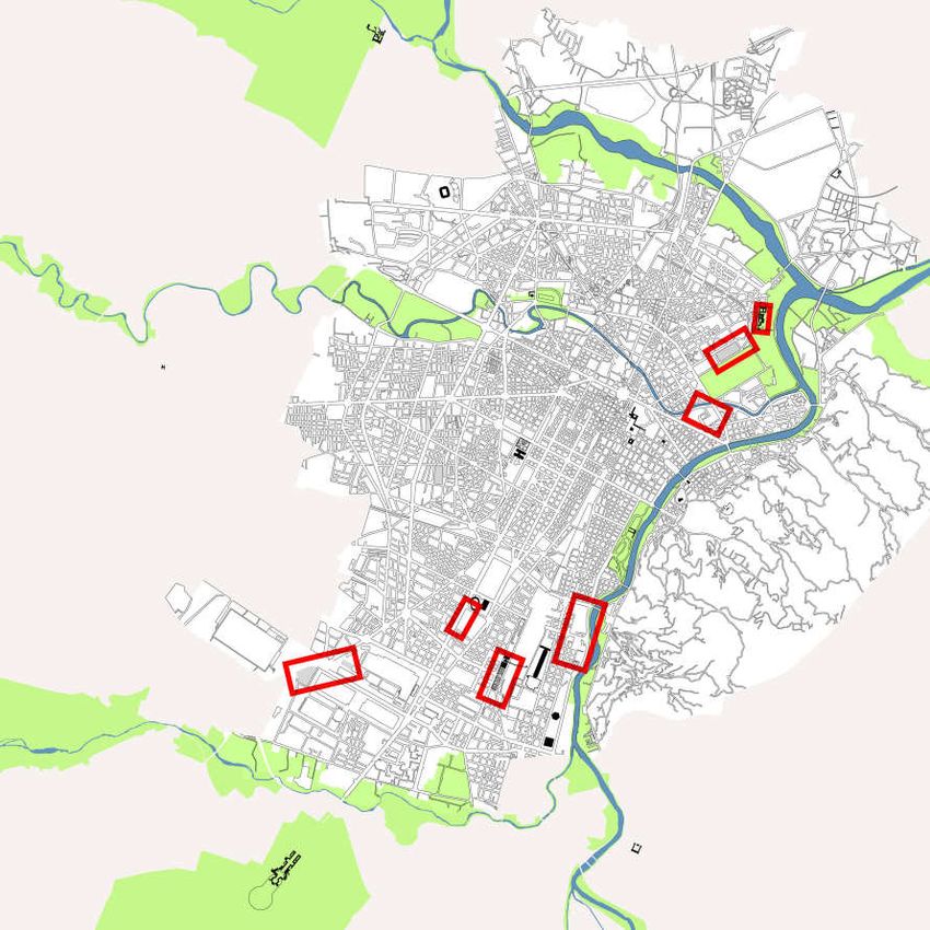
01

            SETTE DISTRETTI, SETTE GEOGRAFIE
         SEVEN DISTRICTS, SEVEN GEOGRAPHIES

                                      2

         6                3       1

                              4

     7           5

 4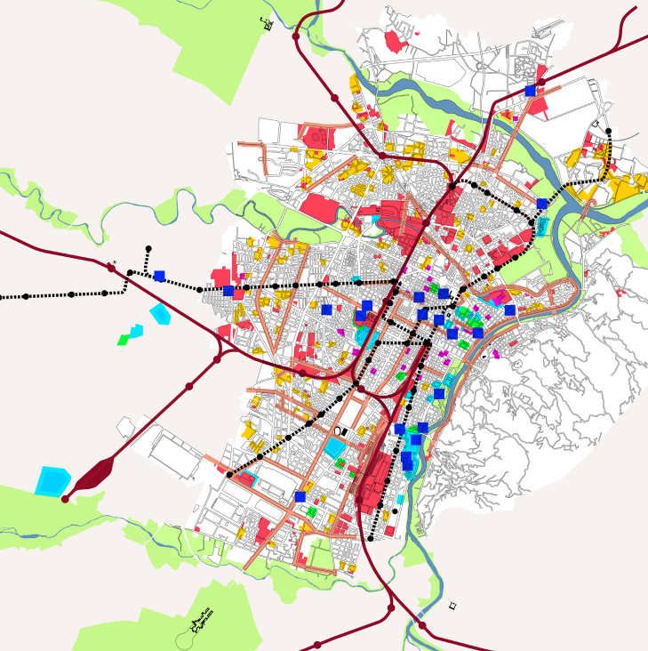
01

Negli ultimi anni l’Università degli Studi e il Politecnico di Torino hanno ridefinito e implementato le
proprie sedi, da un lato attraverso la conservazione e la riqualificazione delle sedi storiche, dall’altro
attraverso un vasto programma di nuove realizzazioni, denotando strategie differenti per i due Atenei:
I) il Politecnico di Torino si concentra su due nuove sedi, la nuova Cittadella Politecnica (ampliamento
della sede di corso Duca degli Abruzzi e fulcro della trasformazione della vasta area di Spina 2) e il
comparto occidentale della Fiat Mirafiori con il nuovo Centro del Design.
II) l’Università degli Studi di Torino ha impostato un modello di Campus Urbano, focalizzandosi lungo due
direttrici fondamentali: il sistema del centro storico della città, che collega le sedi storiche dell’Ateneo
con alcuni interventi in corso di realizzazione – come quello di piazzale Aldo Moro – e che si è negli ultimi
anni allargato fino alle sponde della Dora nell’area della ex Italgas; l’asse del Po, lungo cui si localizzano
le sedi storiche delle Facoltà scientifiche che si sono arricchite di alcuni poli come quello di Orbassano,
con l’Ospedale San Luigi, e di Grugliasco.
Le politiche localizzative degli Atenei hanno contribuito alla definizione di una mappa del sistema
universitario torinese all’interno della quale possiamo ritrovare alcune geografie privilegiate, luoghi
intorno a cui si condensano persone, funzioni, usi, servizi.
I sette distretti-geografie individuati, e che verranno analizzati singolarmente nelle prossime pagine,
sono i seguenti:
1) Polo umanistico / Centro storico e sponde della Dora.
2) Variante 200.
3) Cittadella Politecnica / Spina 2.
4) Polo scientifico-ospedaliero e Architettura / Tra le sponde del Po e la ferrovia.
5) Economia e Centro del Design / Intorno a Mirafiori.
6) Polo scientifico / Grugliasco.
7) Polo ospedaliero / Orbassano.

In recent years the University and the Polytechnic of Turin have been rethinking and restructuring their
premises, on the one hand by conservation and renewal works on their historic sites and on the other
hand by a far-reaching new building programme, with different strategies for the two institutes:
I) Turin Polytechnic to be concentrated in two new sites, the Polytechnic Citadel (extension of the
premises in Corso Duca degli Abruzzi and fulcrum of the transformation of the wide Spina 2 area) and
the west section of Fiat Mirafiori with the new Design Centre.
II) Turin University has set up an Urban Campus model, concentrated along two fundamental axes: the
system of the old city centre, which connects the historic buildings of the institute with some works in
progress – such as that in Piazzale Aldo Moro – and which has been extended in recent years to the
banks of the Dora in the former Italgas area; the line of the Po, along which the historic buildings of
the Scientific faculties are located, supplemented by centres such as Orbassano, with the San Luigi
Hospital, and Grugliasco.
The location policies of the Institutes have contributed to the drafting of a map of the Turin university
system: here we can find some selected “geographies”, i.e. places acting as a point of concentration
for people, functions, uses and services.
The seven geography-districts selected, listed below, will be analysed in the following pages:
1) Humanistic Branch / Old city centre and banks of the Dora.
2) Variante 200.
3) Polytechnic Citadel / Spina 2.
4) Scientific-hospital and Architecture site / Between the banks of the Po and the railway.
5) Economics and Design Centre / Around Mirafiori.
6) Scientific branch / Grugliasco.
7) Hospital branch / Orbassano.

                                                                                                                 5
01
                 Il centro storico di Torino è strutturato intorno al sistema degli assi urbani e delle piazze barocche. Il suo
                 processo di riqualificazione, avviatosi a partire dalla fine degli anni ’90, ha interessato alcuni dei principali
                 edifici storici e il sistema degli spazi aperti. Il Campus urbano che l’Università sta realizzando nel centro di
                 Torino è un sistema che, partendo dalla storica sede del Rettorato in via Po, assume via Verdi come proprio
                 asse portante per poi allargarsi alle zone circostanti. Si struttura così un percorso che si articola fino a
                 Palazzo Nuovo e raggiunge il quartiere Vanchiglia e le sponde della Dora, con la nuova sede della Facoltà
                 di Giurisprudenza e Scienze Politiche nell’area ex Italgas. Un campus diffuso all’interno del tessuto urbano,
                 con il quale si mescola e si integra: da Palazzo Nuovo, attraverso il quartiere Vanchiglia, mescolando le
                 radici produttive di questa parte di città con gli usi e la residenzialità universitari. Già dal 1999 l’Università
                 può disporre degli spazi riqualificati del complesso delle ex Vetrerie Berruto, alle spalle di piazzale Aldo
                 Moro, disponendovi biblioteche e aule universitarie. Più recente è l’intervento nel cuore di Vanchiglia, dove
                 all’interno di un vecchio opificio è stata ricavata la nuova biblioteca della Facoltà di Scienze Letterarie e
                 Filologiche.

                 Turin’s old city centre is structured round a system of urban streets and Baroque squares. Its process of
                 renewal, which began in the late 1990s, has involved some of the main historic buildings and the system
                 of open spaces. The urban Campus that the University is creating in the centre of Turin is a system starting
                 from the historic seat of the Rectory in Via Po, follows Via Verdi as its main axis and then widens into the
                 surrounding areas. In this way a route takes shape, unwinding as far as Palazzo Nuovo, and reaching the
                 Vanchiglia district and the banks of the Dora, with the new site of the Faculty of Jurisprudence and Political
                 Sciences in the former Italgas area. The result is a diffuse campus within the city, with which it blends and
                 integrates: from Palazzo Nuovo, through the Vanchiglia district, blending the productive roots of this part of
                 the city with the university’s uses and residential areas. Already since 1999 the University has been using
                 the converted areas of the former Berruto glassworks complex, behind Piazzale Aldo Moro, where there
                 are now university libraries and lecture halls. More recent are the works in the heart of Vanchiglia, where
                 the new library of the Faculty of Literary and Philological Sciences has been created by converting an old
                 factory building.

Geografia | Geography #1
POLO UMANISTICO. Centro Storico e sponde della Dora
HUMANISTIC BRANCH. The old city centre and the banks of the Dora

   6
01
Variante 200 è il nome con cui è stata chiamata l’operazione di trasformazione urbana che interessa il
quadrante nord-est di Torino. Dal 2008 è in atto un processo che vede i soggetti pubblici e privati lavorare
insieme nella definizione degli scenari di riqualificazione dei due principali ambiti, la Spina 4 lungo il Passante
ferroviario e l’ex scalo merci Vanchiglia. L’opportunità di realizzare la nuova Linea 2 della Metropolitana,
occupando l’ex trincea ferroviaria che attraversa il quartiere, diventa l’occasione per trasformare
oltre un milione di metri quadrati di aree industriali dismesse. Il progetto Torino Città Universitaria può
trovare all’interno di questo contesto urbano in profonda trasformazione un interessante luogo di lavoro,
in particolare per quanto riguarda l’ambito dell’ex scalo merci Vanchiglia. Si tratta oggi di un tessuto
microproduttivo fortemente integrato con usi di natura residenziale, che nelle previsioni della Variante 200
dovrebbe potenziare la propria vocazione di quartiere giovane e creativo. Un’immagine che, sulla scorta
di una serie di iniziative spontanee – come per esempio quella del Bunker di via Paganini – ben si concilia
con usi e funzioni legate alla formazione universitaria, collocandosi all’interno di un contesto ambientale di
grande pregio – racchiuso tra i fiumi Po, Dora e Stura – e prossimo al centro storico e alla nuova sede della
Facoltà di Giurisprudenza e Scienze Politiche nell’area ex Italgas.

Variante 200 is the name given to the urban transformation operation in the north-eastern section of Torino.
Since 2008 a process has been in progress which sees public and private entities working together in
determining the scenarios of renewal of the two main areas, the Spina 4 along the urban railway and the
former Vanchiglia goods yard. The opportunity to build the new Metro Line 2, occupying the former railway
cutting that crosses the district, has become the occasion for transforming over a million square metres
of former industrial areas. This urban context, which is undergoing a thorough transformation, provides an
interesting site of intervention for Torino Città Universitaria, in particular as regards the area of the former
Vanchiglia goods yard. Today this is an area of small-scale production closely integrated with uses of a
residential nature, envisaged under Variante 200 as enhancing its vocation as a young, creative district.
This image, on the basis of a series of spontaneous initiatives – such as the Bunker in Via Paganini –
combines well with the uses and functions linked to university education. It is located within a high-quality
environmental context – bounded by the rivers Po, Dora and Stura – near to the old city centre and the new
site of the Faculty of Law and Political sciences in the former Italgas area.

                                                                                                          Geografia | Geography #2
                                                                                                                     VARIANTE 200
                                                                                                                     VARIANTE 200

                                                                                                                             7
01
                La Spina Centrale è il viale urbano che attraversa la città di Torino da nord a sud. Il viale della Spina
                attraversa grandi ambiti di trasformazione e di riqualificazione urbana, intercettando molte delle principali
                aree industriali dismesse della città. Partendo da sud e salendo verso nord: la Spina 1, la Spina 2 – con
                la nuova stazione di Porta Susa e con i grandi edifici delle OGR e del Politecnico di Torino –, la Spina 3
                e la Spina 4 – con la futura stazione Rebaudengo, attestamento della nuova Linea 2 della Metropolitana.
                In questo quadro si inserisce la cosiddetta Cittadella Politecnica: la grande area di circa 100 mila metri
                quadrati all’interno di Spina 2 ospita l’ampliamento della sede principale del Politecnico di Torino costruita
                negli anni cinquanta. Il nuovo polo occupa oggi una parte delle aree legate alle Officine Grandi Riparazioni:
                aule, laboratori, uffici e il centro di ricerca europeo di General Motors. La prossimità tra il polo universitario
                che ospita ingegneri e architetti, la nuova residenza universitaria Borsellino e il Collegio Einaudi contribuisce
                per quest’area al potenziamento dell’idea di campus urbano.

                The Central Spina is the urban avenue crossing the city of Turin from north to south. The Spina avenue
                passes through large areas of urban transformation and renewal and touches many of the major disused
                industrial areas of the city. Starting from the south and going northward: Spina 1, Spina 2 – with the new
                Porta Susa station and the large buildings of the OGR (former railway repair workshop) and the Turin
                Polytechnic – the Spina 3 and Spina 4 – with the future Rebaudengo station, arrival point of the new Metro
                Line 2. The so-called Polytechnic Citadel enters into this framework: the large area of about 100,000
                square metres within Spina 2 hosts the extension of the principal site of the Turin Polytechnic, built in
                the 1950s. The new site today occupies a part of the areas linked to the OGR: classrooms, laboratories,
                offices and the European research centre of General Motors. The proximity between the university pole,
                hosting engineers and architects, the new Borsellino hall of residence and the Einaudi College contributes
                to enhancing the idea of an urban campus for this area.

Geografia | Geography #3
CITTADELLA POLITECNICA. Spina 2
POLYTECHNIC CITADEL. Spina 2

   8
01
Tra le sponde del fiume Po e il sedime ferroviario si colloca un ambito urbano caratterizzato oggi da
alcune vocazioni privilegiate: in primo luogo la funzione sanitaria, legata alla presenza del principale polo
ospedaliero (Molinette, CTO, OIRM e Sant’Anna), su cui si innestano le attività universitarie disposte lungo
gli assi di via Nizza – con la nuova sede di Biotecnologie – e di corso Massimo d’Azeglio. Funzioni che,
insieme, concorrono alla definizione della “Città della Salute e della Scienza”. Le sponde del Po ospitano
anche l’Orto Botanico dell’Università degli Studi e la sede storica della Facoltà di Architettura del Politecnico
di Torino, che occupa il Castello del Valentino e alcuni edifici lungo corso Massimo d’Azeglio e via Morgari.
Si tratta di funzioni che hanno profondamente caratterizzato il tessuto urbano circostante, connotando San
Salvario anche come quartiere della residenzialità universitaria. Più in generale, è un contesto caratterizzato
da una grande qualità ambientale, con il parco del Valentino e le sponde del Po, e facilmente accessibile
grazie alla presenza della Linea 1 della Metropolitana e della vicina stazione di Porta Nuova. Su questa
geografia insistono oggi una serie di opportunità di trasformazione, legate in particolare ad alcuni grandi
contenitori urbani – il Lingotto, il Palazzo del Lavoro, Torino Esposizioni – e a significative progettualità come
quelle che interessano l’area della ex Fiat Avio, con il Palazzo della Regione Piemonte.

Between the banks of the river Po and the railway land is an urban area that today features some high-
status functions: first and foremost the health function, with the main hospital area (Molinette, CTO, OIRM
and Sant’Anna), taking in the university activities along Via Nizza, with the new Biotechnologies centre, and
Corso Massimo d’Azeglio. These functions together contribute to the definition of a “City of Health and
Science”. The banks of the Po also house the Botanical Garden of the University and the historic site of the
Turin Polytechnic Faculty of Architecture, which occupies the Valentino Castle and some buildings along
Corso Massimo d’Azeglio and Via Morgari. These functions have had a strong impact on the surrounding
urban fabric, characterising San Salvario also as the university residential district. More in general, it is an
area of high environmental quality, with the Valentino park and the banks of the Po, and is easily accessible
thanks to the presence of Metro Line 1 and the nearby Porta Nuova station. On this geography today are
a series of opportunities for transformation linked in particular to large indoor spaces – the Lingotto, the
Palazzo del Lavoro, the Turin Exhibition Centre – and significant projects such as those involving the former
Fiat Avio area, with the Piedmont Regional Building.
                                                                               Geografia | Geography #4
                         POLO SCIENTIFICO-OSPEDALIERO E ARCHITETTURA. Tra le sponde del Po e la ferrovia
                   SCIENTIFIC-HOSPITAL AND ARCHITECTURE SITE. Between the banks of the Po and the railway

                                                                                                                     9
01
                L’ambito è compreso tra corso Unione Sovietica e il limite occidentale della fabbrica della Fiat Mirafiori.
                Sin dai primi anni novanta, l’Università degli Studi di Torino è presente in questa parte di città con la
                Facoltà di Economia e Commercio. Più recentemente anche il Politecnico di Torino ha trovato qui una
                sua nuova sede: è del settembre 2011, infatti, l’inaugurazione del Centro del Design. Il polo della ricerca
                e della didattica occupa una parte dell’edificio dell’ex Dai, compreso tra i corsi Orbassano e Settembrini.
                L’intervento si colloca all’interno della cosiddetta “Zona A”, una delle tre aree dismesse da Fiat – circa
                300 mila metri quadrati – e acquisite nel 2005 dalla Società Torino Nuova Economia (T.N.E. Spa). Questo
                ambito, presenta oggi alcune criticità derivanti dall’inserimento di un polo universitario all’interno di un
                contesto caratterizzato dalle funzioni produttive della Fiat Mirafiori; al tempo stesso si tratta di un ambito
                ricco di opportunità e strategico in una prospettiva di lungo periodo, che vede il Centro del Design e la
                prospiciente piazza Mirafiori come punto di attestamento sud del futuro corso Marche e della nuova Linea
                2 della Metropolitana.

                This area is bounded by Corso Unione Sovietica and the west side of the Fiat Mirafiori factory. Since the
                early 1990s Turin University has been present in this part of the city with the Faculty of Business and
                Economics. More recently also the Turin Polytechnic has found a new site here; the Design Centre was
                inaugurated in September 2011. The research and teaching centre occupies a part of the former “Dai
                building”, bounded by Corso Orbassano and Corso Settembrini. The works are located within the so-
                called “Zone A”, one of the three disused Fiat areas – about 300,000 square metres – and was acquired
                in 2005 by the Torino Nuova Economia company (T.N.E. Spa). This area today presents some problems
                arising from the insertion of a university section alongside the production activities of Fiat Mirafiori, but is
                at the same time an area rich in opportunities, strategic to a long-term perspective, which sees the Design
                Centre and the overlooking Mirafiori as the south arrival point of the future Corso Marche and the new
                Metro Line 2.

Geografia | Geography #5
ECONOMIA E CENTRO DEL DESIGN. Intorno a Mirafiori
ECONOMICS AND DESIGN CENTRE. Around Mirafiori

  10
01
Il polo scientifico di Grugliasco, nel quadrante ovest dell’area metropolitana torinese, comprende le Facoltà
di Agraria e di Medicina Veterinaria dell’Università degli Studi di Torino. Le due facoltà sono rispettivamente
collocate nelle aree dell’ex ospedale psichiatrico e all’interno di un complesso di nove edifici realizzati
tra la metà degli anni novanta e l’inizio del duemila. E’ in corso di studio il progetto di un Polo Scientifico
Universitario, che prevede la realizzazione delle strutture della Facoltà di Scienze Matematiche, Fisiche e
Naturali e della Facoltà di Farmacia in un’area contigua alle sedi esistenti.
The Grugliasco scientific centre, in the west quadrant of the Torino metropolitan area, takes in the Faculties
of Agrarian Science and Veterinary Medicine of the University of Turin. The two faculties are located
respectively in the areas of the former psychiatric hospital and a complex of nine buildings built between
the mid-1990s and the beginning of this century. Plans for a University Scientific Centre are being studied;
they envisage building the structures of the Faculty of Mathematical, Physical and Natural Sciences and the
Faculty of Pharmacy in a area contiguous with the existing sites.
Geografia | Geography #6
POLO SCIENTIFICO. Grugliasco
SCIENTIFIC CENTRE. Grugliasco
1101
Il nuovo complesso di aule e servizi agli studenti della Facoltà di Medicina e Chirurgia e il nuovo Istituto di
Ricerca Scientifica della Fondazione Cavalieri Ottolenghi si collocano all’interno del grande comprensorio
dell’Ospedale San Luigi Gonzaga a Orbassano, nel quadrante sud-ovest dell’area metropolitana torinese.
Si tratta di un’area di oltre 8 mila metri quadrati, facilmente accessibile dalla tangenziale, in un contesto
territoriale caratterizzato prevalentemente da un ambiente agricolo ma anche dalla presenza dello scalo
merci S.I.TO.. È in corso di definizione un intervento volto alla creazione di nuovi spazi da adibire ai
Laboratori di ricerca.
The new complex of classrooms and student services of the Faculty of Medicine and Surgery and the new
Institute of Scientific Research of the Cavalieri Ottolenghi Foundation is located within the large complex
of the San Luigi Gonzaga Hospital at Orbassano, in the south-east quadrant of the Torino metropolitan
area. This is an area of over 8,000 square metres, easily accessible from the by-pass. This is mainly an
agricultural environment but also includes the S.I.T.O goods yard. Works are being planned for the creation
of new spaces to be dedicated to the Research Laboratory.
Geografia | Geography #7
POLO OSPEDALIERO. Orbassano
HOSPITAL CENTRE. Orbassano
1202
LAYERS
LAYERS
1302
La Mappa di Torino Città Universitaria vuole essere uno strumento sintetico; essa si propone di
rappresentare uno scenario d’insieme capace di far leggere tanto gli elementi di struttura – fiumi e telai
urbani –, quanto gli elementi esistenti e in progetto legati alle funzioni universitarie.
La Mappa è organizzata per “layers”:
1) Rete del sistema ambientale.
2) Sistema della mobilità pubblica.
3) Sistema dei parcheggi.
4) Sistema delle piste ciclabili.
5) Sedi universitarie.
6) Residenze universitarie.
7) Biblioteche.
8) Aree Z.U.T.
The Torino Città Universitaria Map is intended as a summarising instrument; it aims to represent an
overall scenario that can show both the elements of structure – rivers and urban framework – and the
existing and planned elements linked to university functions.
The Map is organized in “layers”:
1) Network of the environmental system.
2) Public mobility system.
3) Parking system.
4) Cycle paths.
5) University Sites.
6) University Residences.
7) Libraries.
8) Z.U.T. Areas.
1402
RETE DEL SISTEMA AMBIENTALE SISTEMA DELLA MOBILITÀ PUBBLICA
ENIVRONMENTAL SYSTEM NETWORK PUBLIC MOBILITY SYSTEM
Il Layer 1 è costituito dal telaio ambientale alla scala metropolitana: i Il Layer 2 è costituito dal telaio infrastrutturale alla scala metropolitana: le
quattro fiumi, il sistema dei parchi e delle residenze Sabaude, i progetti di due linee della metropolitana esistenti e in progetto, il Servizio Ferroviario
Corona verde e Torino Città d’Acque. metropolitano, il sistema tangenziale.
Layer 1 consists of the environmental network on a metropolitan scale: Layer 2 consists of the infrastructural framework on a metropolitan scale:
the four rivers, the Sabaud system of parks and residences, the Corona the two metro lines, existing and planned, the urban railway service, the
verde and Torino Città d’Acque projects. tangential system.
SISTEMA DEI PARGHEGGI SISTEMA DELLE PISTE CICLABILI
PARKING SYSTEM CYCLE PATHS
Il Layer 3 è costituito dal sistema dei parcheggi esistenti. Il Layer 4 è costituito dal sistema delle piste ciclabili. In arancione le piste
Layer 3 consists of the existing parking system. ciclabili esistenti.
Layer 4 consists of the cycle paths system. In orange are the existing
cycle paths.
1502
SEDI UNIVERSITARIE RESIDENZE UNIVERSITARIE
UNIVERSITY SITES UNIVERSITY HALLS OF RESIDENCE
Il Layer 5 è costituto dalle principali sedi universitarie. In azzurro le sedi Il Layer 6 descrive il sistema delle residenze universitarie presenti a Torino
dell’Università degli Studi di Torino e del Politecnico di Torino. e nella sua area metropolitana. In rosa le residenza universitarie EdISU
Layer 5 consists of the main university sites. In sky-blue are the sites of Piemonte, l’ente regionale per il diritto allo studio. In verde le residenze
the Turin University and the Turin Polytechnic. universitarie private.
Layer 6 describes the system of university halls of residence in Torino
and its metropolitan area. In pink are the university residences of the
EdISU Piemonte, the regional body for student support. In green are the
private halls of residence.
BIBLIOTECHE AREE Z.U.T.
LIBRARIES Z.U.T. AREAS
Il Layer 7 rappresenta il sistema delle biblioteche torinesi. In rosa le Il Layer 8 rappresenta le Z.U.T. (Zone Urbane di Trasformazione) inviduate
Biblioteche dell’Università degli Studi di Torino. In giallo le Biblioteche del dal Prg di Torino, ambiti all’interno dei quali attuare delle trasformazioni
Politecnico di Torino. In verde le Biblioteche Civiche di Torino. urbane orientate agli usi e alle funzioni universitarie.
Layer 7 represents the Torino libraries system. In pink, the Turin University Layer 8 represents the Z.U.T. (Urban Zones of Transformation)
Libraries. In yellow the Turin Polytechnic libraries. In green the Turin Public selected by the Turin Local Strategic Plan, areas for carrying out urban
Libraries. transformations oriented to university uses and functions.
1603
RESIDENZE UNIVERSITARIE
NUOVE PROPOSTE
UNIVERSITY HALLS OF RESIDENCE
NEW PROPOSALS
2
3
1
6
4
7
5
1703
Le aree descritte di seguito rientrano all’interno del progetto Torino Città Universitaria come possibili
ambiti di localizzazione per le nuove residenze e i servizi universitari. Si tratta di ambiti di trasformazione
e riqualificazione urbana che possono rappresentare opportunità interessanti in virtù della loro posizione
strategica all’interno del tessuto urbano, vicina ai poli universitari esistenti, in contesti qualificati dal punto
di vista ambientale e facilmente accessibili. Queste aree si inseriscono all’interno delle 7 geografie/
distretti prima descritti. Le aree sono:
1. Area ex Italgas.
2. Manifattura Tabacchi.
3. V200 / Scalo Vanchiglia.
4. Città della Salute.
5. Ex Moi.
6. Ex Combi.
7. Mirafiori TNE.
The areas described below come under the Torino Città Universitaria project as possible areas for
locating the new halls of residence and university services. These are areas of urban transformation
and renewal that can represent interesting opportunities because of their strategic position within the
urban fabric near to the existing centres, in an easily accessible context of high environmental quality.
These areas are included in the 7 geographies/districts described earlier. The areas are:
1. Former Italgas.
2. Tobacco Manufacturing Building.
3. V200 / Vanchiglia Rail yards.
4. City of Health.
5. Former Moi.
6. Former Combi.
7. Mirafiori TNE.
1803
L’area ex Italgas, compresa tra la Dora e corso Regina Margherita, si colloca all’interno del più ampio
progetto di Campus urbano realizzato in questi ultimi anni dall’Università degli Studi di Torino, che dal centro
storico della città arriva fino alle sponde fluviali. In prospettiva, l’ex Italgas è strategica per la sua posizione
baricentrica, compresa tra lo storico sistema universitario e le trasformazioni legate alla Variante 200 e
all’ex Scalo Vanchiglia. L’area ospita già la nuova sede della Facoltà di Giurisprudenza e Scienze Politiche
e la residenza universitaria Lungodora completata nel 2005. Il Campus può essere ampliato sull’area
attualmente occupata dai gasometri con nuove residenze universitarie e servizi per gli studenti.
The former Italgas area, bounded by the river Dora and Corso Regina Margherita, is located within the wider
Urban Campus project carried out in the last few years by the University of Turin, which extends from the
old city centre to the river banks. The ex-Italgas site is strategic to the plans, given its position as a centre
of gravity, surrounded by the historic university system, and the transformations linked to Variante 200 and
the former Vanchiglia Goods Yard. The area already hosts the new site of the Faculty of Law and Political
Sciences and the Longodora hall of residence completed in 2005. The Campus can be extended on the
area at present occupied by gasometers with new university residences and services for students.
1. EX ITALGAS | FORMER ITALGAS
Geografia #2. Variante 200
Geography #2. Variante 200
1903
La Manifattura Tabacchi rappresenta un insediamento storico di straordinario interesse, da tempo
destinato nei progetti della città a funzioni universitarie (già oggi sono presenti qui alcuni uffici e funzionalità
dell’Università degli Studi di Torino). Collocata lungo il fiume Po, circondato dai parchi della Colletta e
dell’Arrivore, risulta essere prossima alle aree di trasformazione della Variante 200 – in particolare dello
Scalo Vanchiglia – e al tracciato della futura Linea 2 della Metropolitana. Il contesto storico e ambientale, la
prossimità ai percorsi delle nuove infrastrutture, ma anche al nuovo polo umanistico lungo la Dora, fanno
della Manifattura Tabacchi un sito di particolare interesse.
The former Tobacco Manufacturing Plant represents a historic structure of extraordinary interest, log
destined in the City’s plans to university functions (already today there are offices and functions of the
University of Turin). Located along the river Po, surrounded by the Colletta and Arrivore parks, it borders
on the transformation areas of Variante 200 – in particular the Vanchiglia Goods Yard – and the route of
the future Metro Line 2. The historical and environmental context, the nearness to the new public transport
routes but also to the new humanistic site along the Dora, makes the Tobacco Manufacturing Building a
site of particular interest.
2. MANIFATTURA TABACCHI | TOBACCO MANUFACTURING BUILDING
Geografia #2. Variante 200
Geography #2. Variante 200
2003
La Variante 200 costituisce uno dei principali progetti di trasformazione della città e dell’area metropolitana
torinese. Nel quadrante nord dello spazio urbano, lungo il tracciato della futura Linea 2 della Metropolitana,
circa un milione di metri quadrati di aree industriali e infrastrutturali dismesse sono destinate ad un processo
di profonda riqualificazione urbanistica e ambientale. All’interno dello Scalo Vanchiglia è possibile immaginare
la realizzazione di insediamenti residenziali universitari e di servizi, con l’obiettivo di incrementare il grado di
qualità abitativa dell’intera area. In particolare, la presenza della Manifattura Tabacchi – e la vicinanza con il
polo universitario della Dora – fanno dello Scalo Vanchiglia un ambito particolarmente interessante.
Variante 200 is one of the main projects for transforming the Turin city and metropolitan area. In the north
quadrant of the urban space, along the route of the future Metro Line 2, about a million square metres
of disused industrial and infrastructural areas are destined to a process of thorough-going urban and
environmental renewal. Within Vanchiglia Rail yards one can imagine the creation of university halls of
residence and services, with the aim of increasing the degree of livability of the entire area. In particular the
presence of the former Tobacco Manufacturing Plant – and the nearness to the Dora university site – make
the Vanchiglia Goods Yard a particularly interesting site.
3. V200. SCALO VANCHIGLIA | V200. VANCHIGLIA RAIL YARDS
Geografia #2. Variante 200
Geography #2. Variante 200
2103
Da tempo si discute della realizzazione di un nuovo distretto sanitario, una vera e propria Città della Salute,
dove concentrare le eccellenze ospedaliere, la ricerca universitaria, i servizi e le connesse attività di incubatori.
La Città della Salute dovrebbe nascere dalla ridefinizione del principale polo ospedaliero dell’area torinese,
quello delle Molinette, per poi estendersi e irradiarsi al tessuto urbano circostante, all’interno del quadrante
sud della città. Qui il quadro ambientale rappresentato dal Po e dal paesaggio fluviale, la presenza della
Linea Metropolitana 1 e la vicinanza alla stazione ferroviaria del Lingotto e agli accessi autostradali, rendono
quest’area particolarmente interessante sotto il profilo insediativo.
There has been discussion for some time as to the creation of a new health district, a veritable City of
Health, where top-level hospital services, university research, incubator services and connected activities
can be concentrated. The City of Health should arise from the redesigning of the principal hospital site of
the Turin area, the Molinette, to then extend and spread out to the surrounding urban fabric, within the
south quadrant of the city. Here the environmental picture represented by the Po and the river landscape,
the presence of Metro Line 1 and the nearness to the Lingotto railway station and motorway access roads
make this area particularly interesting for development.
4. CITTA’ DELLA SALUTE | CITY OF HEALTH
Geografia #4. Polo scientifico-ospedaliero e Architettura. Tra le sponde del Po e la ferrovia
Geography #4. Scientific-hospital and Architecture site. Between the banks of the Po and the railway
2203
Intorno all’ex stabilimento della FIAT Lingotto, stanno prendendo corpo nuove iniziative di trasformazione e
riqualificazione urbana:
1. la nuova torre della Regione Piemonte e del quartiere circostante, a cui si aggiungono una serie di
interventi alla scala urbana sul lato occidentale e orientale della ferrovia;
2. gli ex Mercati ortofrutticoli della città;
3. l’ex Moi, già riqualificato per i Giochi Olimpici Invernali del 2006.
Questo dinamico distretto urbano di Torino, oltre ad essere posto in prossimità di importanti accessi
autostradali, è servito a livello infrastrutturale dalla Linea 1 della Metropolitana e dalla stazione ferroviaria
del Lingotto ed è prossimo al polo scientifico e ospedaliero che caratterizza il quadrante sud-orientale della
città.
Around the former FIAT Lingotto factory, new transformation and urban renewal plans are taking shape:
1. the new tower of Piedmont Region and the surrounding district, added to which are a series of actions
on an urban scale on the west and east sides of the railway;
2. former fruit and vegetable markets of the city:
3. former Moi, already upgraded for the 2006 Winter Olympics.
This dynamic urban district of Turin, is situated in the proximity of important motorway accesses and is
also served by Metro Line 1 and the Lingotto railway station. It is near the scientific and hospital site that
dominates the south-east quadrant of the city.
5. EX MOI | FORMER MOI
Geografia #4. Polo scientifico-ospedaliero e Architettura. Tra le sponde del Po e la ferrovia
Geography #4. Scientific-hospital and Architecture site. Between the banks of the Po and the railway
2303
L’area si colloca in una posizione strategica, compresa tra il complesso urbano riqualificato per i XX Giochi
Olimpici Invernali del 2006 e il polo universitario delle facoltà economiche nell’area dei Poveri Vecchi. La
realizzazione del PalaIsozaki, insieme alla trasformazione del Comunale in Stadio Olimpico, ha dato avvio
ad un più generale processo di riqualificazione di questa parte di città, che ha investito lo spazio aperto
pubblico, ma anche nuovi spazi per il loisir e di servizio. L’area Combi, un tempo occupata da campi di
allenamento, è oggi uno spazio abbandonato e incolto della dimensione di circa trentamila metri quadrati.
L’area si presta a diventare una nuova centralità legata a strutture di servizio urbano e universitario, grazie
anche alla presenza delle vicine Facoltà Economiche.
This area is in a strategic position, between the converted 2006 Winter Olympics urban complex and the
university site of the economics faculties in the Poveri Vecchi area. The building of the Palaisozaki (Olympic
indoor stadium), together with the transformation of the City Stadium to Olympic level, has given rise to
a more general process of renewal of this part of the city, involving the public open space, but also new
spaces for leisure and services. The Combi area, which used to be occupied by training fields, is today an
abandoned, uncultivated area of about 30,000 square metres. The area is appropriate for a new central
role linked to urban and university service structures, thanks also to the presence of the nearby Economics
faculties.
6. EX COMBI | FORMER COMBI
Geografia #5. Economia e Centro del Design. Intorno a Mirafiori
Geography #5. Economics and Design Centre. Around Mirafiori
2403
Nel quadrante sud-occidentale del territorio torinese, in posizione strategica rispetto alla tangenziale e alle
autostrade, nonché alle spalle dello storico insediamento industriale di FIAT Mirafiori, si collocano le aree di
Torino Nuova Economia (T.N.E.), zone industriali dismesse in corso di riqualificazione. Qui hanno già trovato
ospitalità i corsi di laurea di Design del Politecnico di Torino e altre funzioni e servizi a carattere innovativo
dovrebbero presto aggiungersi. Sulla cosiddetta “piazza Mirafiori”, nel baricentro delle aree T.N.E., si
collocherà inoltre il capolinea sud della futura Linea 2 della Metropolitana.
The south-west quadrant of the Turin territory, in a strategic position in relation to the by-pass and the
motorways, as well as flanking the historic industrial site of FIAT Mirafiori, is the location of the Torino Nuova
Economia (T.N.E.) areas, which are disused industrial areas undergoing renewal. This area has already
become home to the Design degree courses of the Turin Polytechnic and other functions and services of
an innovative nature should soon be added. The so-called “piazza Mirafiori” at the centre of gravity of the
T.N.E. areas will also be the location of the south terminus of the future Metro Line 2.
7. MIRAFIORI T.N.E. | MIRAFIORI T.N.E.
Geografia #5. Economia e Centro del Design. Intorno a Mirafiori
Geography #5. Economics and Design Centre. Around Mirafiori
25Puoi anche leggere