Smart City planning far energy, transportation an d sustainability of the urban system - Journal of Land Use, Mobility and ...
←
→
Trascrizione del contenuto della pagina
Se il tuo browser non visualizza correttamente la pagina, ti preghiamo di leggere il contenuto della pagina quaggiù
Smart City planning far energy, transportation an d sustainability of the urban system
TeMA                                                            Journal of
                                                                Land Use, Mobility and
                                                                Environment

SMART CITY
PLANNING FOR ENERGY, TRANSPORTATION AND
SUSTAINABILITY OF THE URBAN SYSTEM
Special Issue, June 2014

Published by
Laboratory of Land Use Mobility and Environment
DICEA - Department of Civil, Architectural and Environmental Engineering
University of Naples "Federico II"

TeMA is realised by CAB - Center for Libraries at “Federico II” University of Naples using Open Journal System

Editor-in-chief: Rocco Papa
print ISSN 1970-9889 | on line ISSN 1970-9870
Lycence: Cancelleria del Tribunale di Napoli, n° 6 of 29/01/2008

Editorial correspondence
Laboratory of Land Use Mobility and Environment
DICEA - Department of Civil, Architectural and Environmental Engineering
University of Naples "Federico II"
Piazzale Tecchio, 80
80125 Naples
web: www.tema.unina.it
e-mail: redazione.tema@unina.it

 TeMA Journal of Land Use Mobility and Environment INPUT 2014       Eighth International Conference INPUT - Naples, 4-6 June 2014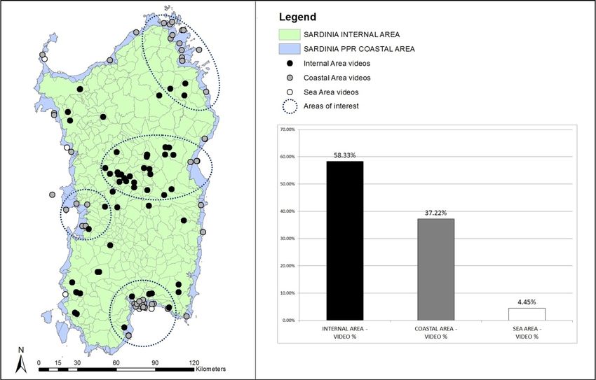
TeMA                                                                   Journal of
                                                                        Land Use, Mobility and
                                                                        Environment

TeMA. Journal of Land Use, Mobility and Environment offers researches, applications and contributions with a unified approach to planning
and mobility and publishes original inter-disciplinary papers on the interaction of transport, land use and environment. Domains include
engineering, planning, modeling, behavior, economics, geography, regional science, sociology, architecture and design, network science,
and complex systems.
The Italian National Agency for the Evaluation of Universities and Research Institutes (ANVUR) classified TeMA as scientific journals in the
Areas 08. TeMA has also received the Sparc Europe Seal for Open Access Journals released by Scholarly Publishing and Academic
Resources Coalition (SPARC Europe) and the Directory of Open Access Journals (DOAJ). TeMA is published under a Creative Commons
Attribution 3.0 License and is blind peer reviewed at least by two referees selected among high-profile scientists by their competences.
TeMA has been published since 2007 and is indexed in the main bibliographical databases and it is present in the catalogues of hundreds
of academic and research libraries worldwide.

EDITOR - IN - CHIEF

Rocco Papa, Università degli Studi di Napoli Federico II, Italy

E DITORIAL A DVISORY B OARD

Luca Bertolini, Universiteit van Amsterdam, Netherlands
Virgilio Bettini, Università Iuav di Venezia, Italy
Dino Borri, Politecnico di Bari, Italy
Enrique Calderon, Universidad Politécnica de Madrid, Spain
Roberto Camagni, Politecnico di Milano, Italy
Robert Leonardi, London School of Economics and Political Science, United Kingdom
Raffaella Nanetti, College of Urban Planning and Public Affairs, United States
Agostino Nuzzolo, Università degli Studi di Roma Tor Vergata, Italy
Rocco Papa, Università degli Studi di Napoli Federico II, Italy

E DITORS

Agostino Nuzzolo, Università degli Studi di Roma Tor Vergata, Italy
Enrique Calderon, Universidad Politécnica de Madrid, Spain
Luca Bertolini, Universiteit van Amsterdam, Netherlands
Romano Fistola, Dept. of Engineering - University of Sannio - Italy, Italy
Adriana Galderisi, Università degli Studi di Napoli Federico II, Italy
Carmela Gargiulo, Università degli Studi di Napoli Federico II, Italy
Giuseppe Mazzeo, CNR - Istituto per gli Studi sulle Società del Mediterraneo, Italy

E DITORIAL SECRETARY
Rosaria Battarra, CNR - Istituto per gli Studi sulle Società del Mediterraneo, Italy
Andrea Ceudech, TeMALab, Università degli Studi di Napoli Federico II, Italy
Rosa Anna La Rocca, TeMALab, Università degli Studi di Napoli Federico II, Italy
Enrica Papa, University of Amsterdam, Netherlands

   TeMA Journal of Land Use Mobility and Environment INPUT 2014                  Eighth International Conference INPUT - Naples, 4-6 June 2014
TeMA                                                                Journal of
                                                                     Land Use, Mobility and
                                                                     Environment

This special issue of TeMA collects the papers presented at the 8th International Conference
INPUT 2014 which will take place in Naples from 4th to 6th June. The Conference focuses on one
of the central topics within the urban studies debate and combines, in a new perspective,
researches concerning the relationship between innovation and management of city changing.

C ONFERENCE C OMMITTEE

Dino Borri, Polytechnic University of Bari, Italy
Arnaldo Cecchini, University of Sassari, Italy
Romano Fistola, University of Sannio, Italy
Lilli Gargiulo, University of Naples Federico II, Italy
Giuseppe B. Las Casas, University of Basilicata, Italy
Agostino Nuzzolo, University of Rome, Italy
Rocco Papa, University of Naples Federico II, Italy
Giovanni Rabino, Polytechnic University of Milan, Italy
Maurizio Tira, University of Brescia, Italy
Corrado Zoppi, University of Cagliari, Italy

S CIENTIFIC C OMMITTEE

Emanuela Abis, University of Cagliari, Italy
Nicola Bellini, Institute of Management, Scuola Superiore Sant'Anna Pisa, Italy
Mariolina Besio Dominici, University of Genoa, Italy
Ivan Blecic, University of Sassari, Italy
Dino Borri, Polytechnic University of Bari, Italy
Grazia Brunetta, Polytechnic University of Turin, Italy
Roberto Busi, University of Brescia, Italy
Domenico Camarda, Polytechnic University of Bari, Italy
Michele Campagna, University of Cagliari, Italy
Arnaldo Cecchini, University of Sassari, Italy
Donatella Cialdea, University of Molise, Italy
Valerio Cutini, University of Pisa, Italy, Italy
Luciano De Bonis, University of Molise, Italy
Andrea De Montis, University of Sassari, Italy
Filippo de Rossi, University of Sannio (Dean of the University of Sannio), Italy
Lidia Diappi, Polytechnic University of Milan, Italy
Isidoro Fasolino, University of Salerno, Italy
Mariano Gallo, University of Sannio, Italy
Lilli Gargiulo, University of Naples Federico II, Italy
Roberto Gerundo, University of Salerno, Italy
Paolo La Greca, University of Catania, Italy
Giuseppe B. Las Casas, University of Basilicata, Italy
Robert Laurini, University of Lyon, France
Antonio Leone, Tuscia University, Italy
Anna Loffredo,Institute of Management, Scuola Superiore Sant'Anna Pisa, Italy
Silvana Lombardo, University of Pisa, Italy
Giovanni Maciocco, University of Sassari, Italy
Giulio Maternini, University of Brescia, Italy

  TeMA Journal of Land Use Mobility and Environment INPUT 2014               Eighth International Conference INPUT - Naples, 4-6 June 2014
TeMA                                                            Journal of
                                                                 Land Use, Mobility and
                                                                 Environment

Francesco Domenico Moccia, University of Naples Federico II, Italy
Bruno Montella, University of Naples “Federico II” (Director of DICEA), Italy
Beniamino Murgante, University of Basilicata, Italy
Agostino Nuzzolo, University of Rome, Italy
Sylvie Occelli, IRES Turin, Italy
Rocco Papa, University of Naples Federico II, Italy
Maria Paradiso, University of Sannio, Italy
Domenico Patassini, IUAV, Venice, Italy
Michele Pezzagno, University of Brescia, Italy
Fulvia Pinto, Polytechnic University of Milan, Italy
Giovanni Rabino, Polytechnic University of Milan, Italy
Giuseppe Roccasalva, Polytechnic University of Turin, Italy
Bernardino Romano, University of L’Aquila, Italy
Francesco Russo, Mediterranean University Reggio Calabria, Italy
Michelangelo Russo, University of Naples Federico II, Italy
Ferdinando Semboloni, University of Firenze, Italy
Agata Spaziante, Polytechnic University of Turin, Italy
Michela Tiboni, University of Brescia, Italy
Maurizio Tira, University of Brescia, Italy
Simona Tondelli, University of Bologna, Italy
Umberto Villano,University of Sannio (Director of DING), Italy
Ignazio Vinci, University of Palermo, Italy
Corrado Zoppi, University of Cagliari, Italy

L OCAL S CIENTIFIC C OMMITTEE

Rosaria Battarra, ISSM, National Research Council, Italy
Romano Fistola, DING, University of Sannio, Italy
Lilli Gargiulo, DICEA, University of Naples Federico II, Italy
Adriana Galderisi, DICEA, University of Naples Federico II, Italy
Rosa Anna La Rocca, DICEA, University of Naples Federico II, Italy
Giuseppe Mazzeo, ISSM, National Research Council, Italy
Enrica Papa, University of Amsterdam, Netherlands

L OCAL A DMINISTRATIVE T EAM

Gennaro Angiello, TeMA Lab, University of Naples Federico II, Italy
Gerardo Carpentieri, TeMA Lab, University of Naples Federico II, Italy
Stefano Franco, TeMA Lab, University of Naples Federico II, Italy
Laura Russo, TeMA Lab, University of Naples Federico II, Italy
Floriana Zucaro, TeMA Lab, University of Naples Federico II, Italy

  TeMA Journal of Land Use Mobility and Environment INPUT 2014       Eighth International Conference INPUT - Naples, 4-6 June 2014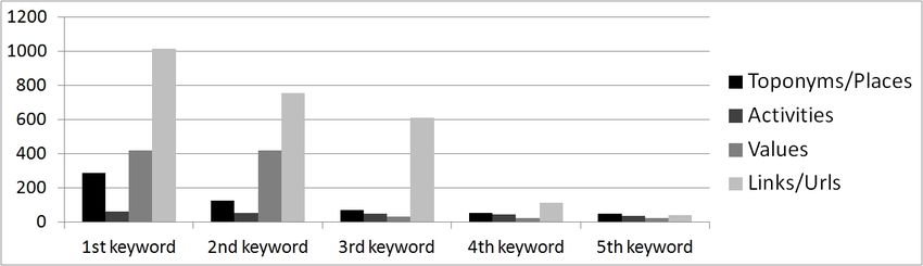
TeMA                                                              Journal of
                                                                   Land Use, Mobility and
                                                                   Environment

EIGHTH INTERNATIONAL CONFERENCE INPUT 2014

SMART CITY. PLANNING FOR ENERGY, TRANSPORTATION AND SUSTAINABILITY OF THE
URBAN SYSTEM
This special issue of TeMA collects the papers presented at the Eighth International Conference INPUT, 2014,
titled "Smart City. Planning for energy, transportation and sustainability of the urban system" that takes place in
Naples from 4 to 6 of June 2014.

INPUT (Innovation in Urban Planning and Territorial) consists of an informal group/network of academic
researchers Italians and foreigners working in several areas related to urban and territorial planning. Starting
from the first conference, held in Venice in 1999, INPUT has represented an opportunity to reflect on the use of
Information and Communication Technologies (ICTs) as key planning support tools. The theme of the eighth
conference focuses on one of the most topical debate of urban studies that combines , in a new perspective,
researches concerning the relationship between innovation (technological, methodological, of process etc..) and
the management of the changes of the city. The Smart City is also currently the most investigated subject by
TeMA that with this number is intended to provide a broad overview of the research activities currently in place
in Italy and a number of European countries. Naples, with its tradition of studies in this particular research field,
represents the best place to review progress on what is being done and try to identify some structural elements
of a planning approach.

Furthermore the conference has represented the ideal space of mind comparison and ideas exchanging about a
number of topics like: planning support systems, models to geo-design, qualitative cognitive models and formal
ontologies, smart mobility and urban transport, Visualization and spatial perception in urban planning innovative
processes for urban regeneration, smart city and smart citizen, the Smart Energy Master project, urban entropy
and evaluation in urban planning, etc..

The conference INPUT Naples 2014 were sent 84 papers, through a computerized procedure using the website
www.input2014.it . The papers were subjected to a series of monitoring and control operations. The first
fundamental phase saw the submission of the papers to reviewers. To enable a blind procedure the papers have
been checked in advance, in order to eliminate any reference to the authors. The review was carried out on a
form set up by the local scientific committee. The review forms received were sent to the authors who have
adapted the papers, in a more or less extensive way, on the base of the received comments. At this point (third
stage), the new version of the paper was subjected to control for to standardize the content to the layout required
for the publication within TeMA. In parallel, the Local Scientific Committee, along with the Editorial Board of the
magazine, has provided to the technical operation on the site TeMA (insertion of data for the indexing and
insertion of pdf version of the papers). In the light of the time’s shortness and of the high number of contributions
the Local Scientific Committee decided to publish the papers by applying some simplifies compared with the
normal procedures used by TeMA. Specifically:

−      Each paper was equipped with cover, TeMA Editorial Advisory Board, INPUT Scientific Committee,
       introductory page of INPUT 2014 and summary;

−      Summary and sorting of the papers are in alphabetical order, based on the surname of the first author;

−      Each paper is indexed with own DOI codex which can be found in the electronic version on TeMA website
       (www.tema.unina.it). The codex is not present on the pdf version of the papers.

    TeMA Journal of Land Use Mobility and Environment INPUT 2014       Eighth International Conference INPUT - Naples, 4-6 June 2014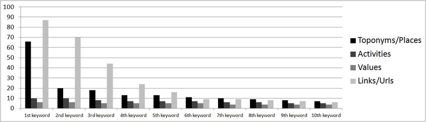
TeMA                                                            Journal of
                                                                Land Use, Mobility and
                                                                Environment

SMART CITY
PLANNING FOR ENERGY, TRANSPORTATION AND
SUSTAINABILITY OF THE URBAN SYSTEM
Special Issue, June 2014

Contents

1. The Plan in Addressing the Post Shock Conflicts 2009-2014.
   A First Balance Sheet of the Reconstruction of L’Aquila                                                               1-13
    Fabio Andreassi, Pierluigi Properzi

2. Assessment on the Expansion of Basic Sanitation Infrastructure.
   In the Metropolitan Area of Belo Horizonte - 2000/2010                                                              15-26
    Grazielle Anjos Carvalho

3. Temporary Dwelling of Social Housing in Turin.
   New Responses to Housing Discomfort                                                                                 27-37
    Giulia Baù, Luisa Ingaramo

4. Smart Communities. Social Innovation at the Service of the Smart Cities                                             39-51
    Massimiliano Bencardino, Ilaria Greco

5. Online Citizen Reporting on Urban Maintenance:
   A Collection, Evaluation and Decision Support System                                                                53-63
    Ivan Blečić, Dario Canu, Arnaldo Cecchini, Giuseppe Andrea Trunfio

6. Walkability Explorer. An Evaluation and Design Support Tool for Walkability                                         65-76
    Ivan Blečić, Arnaldo Cecchini, Tanja Congiu, Giovanna Fancello, Giuseppe Andrea Trunfio

7. Diachronic Analysis of Parking Usage: The Case Study of Brescia                                                     77-85
    Riccardo Bonotti, Silvia Rossetti, Michela Tiboni, Maurizio Tira

8. Crowdsourcing. A Citizen Participation Challenge                                                                    87-96
    Júnia Borges, Camila Zyngier

9. Spatial Perception and Cognition Review.
   Considering Geotechnologies as Urban Planning Strategy                                                            97-108
    Júnia Borges, Camila Zyngier, Karen Lourenço, Jonatha Santos

 TeMA Journal of Land Use Mobility and Environment INPUT 2014       Eighth International Conference INPUT - Naples, 4-6 June 2014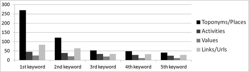
TeMA                                                            Journal of
                                                                Land Use, Mobility and
                                                                Environment

10. Dilemmas in the Analysis of Technological Change. A Cognitive Approach
    to Understand Innovation and Change in the Water Sector                                                        109-127
    Dino Borri, Laura Grassini

11. Learning and Sharing Technology in Informal Contexts.
    A Multiagent-Based Ontological Approach                                                                        129-140
    Dino Borri, Domenico Camarda, Laura Grassini, Mauro Patano

12. Smartness and Italian Cities. A Cluster Analysis                                                               141-152
    Flavio Boscacci, Ila Maltese, Ilaria Mariotti

13. Beyond Defining the Smart City.
    Meeting Top-Down and Bottom-Up Approaches in the Middle                                                        153-164
    Jonas Breuer, Nils Walravens, Pieter Ballon

14. Resilience Through Ecological Network                                                                          165-173
    Grazia Brunetta, Angioletta Voghera

15. ITS System to Manage Parking Supply:
    Considerations on Application to the “Ring” in the City of Brescia                                             175-186
    Susanna Bulferetti, Francesca Ferrari, Stefano Riccardi

16. Formal Ontologies and Uncertainty. In Geographical Knowledge                                                   187-198
    Matteo Caglioni, Giovanni Fusco

17. Geodesign From Theory to Practice:
    In the Search for Geodesign Principles in Italian Planning Regulations                                         199-210
    Michele Campagna, Elisabetta Anna Di Cesare

18. Geodesign from Theory to Practice:
    From Metaplanning to 2nd Generation of Planning Support Systems                                                211-221
    Michele Campagna

19. The Energy Networks Landscape.
    Impacts on Rural Land in the Molise Region                                                                     223-234
    Donatella Cialdea, Alessandra Maccarone

20. Marginality Phenomena and New Uses on the Agricultural Land.
    Diachronic and Spatial Analyses of the Molise Coastal Area                                                     235-245
    Donatella Cialdea, Luigi Mastronardi

21. Spatial Analysis of Urban Squares. ‘Siccome Umbellico al corpo dell’uomo’                                      247-258
    Valerio Cutini

 TeMA Journal of Land Use Mobility and Environment INPUT 2014       Eighth International Conference INPUT - Naples, 4-6 June 2014
TeMA Journal of
Land Use, Mobility and
Environment
22. Co-Creative, Re-Generative Smart Cities.
Smart Cities and Planning in a Living Lab Perspective 2 259-270
Luciano De Bonis, Grazia Concilio, Eugenio Leanza, Jesse Marsh, Ferdinando Trapani
23. The Model of Voronoi's Polygons and Density:
Diagnosis of Spatial Distribution of Education Services of EJA
in Divinópolis, Minas Gerais, Brazil 271-283
Diogo De Castro Guadalupe, Ana Clara Mourão Moura
24. Rural Architectural Intensification: A Multidisciplinar Planning Tool 285-295
Roberto De Lotto, Tiziano Cattaneo, Cecilia Morelli Di Popolo, Sara Morettini,
Susanna Sturla, Elisabetta Venco
25. Landscape Planning and Ecological Networks.
Part A. A Rural System in Nuoro, Sardinia 297-307
Andrea De Montis, Maria Antonietta Bardi, Amedeo Ganciu, Antonio Ledda,
Simone Caschili, Maurizio Mulas, Leonarda Dessena, Giuseppe Modica,
Luigi Laudari, Carmelo Riccardo Fichera
26. Landscape Planning and Ecological Networks.
Part B. A Rural System in Nuoro, Sardinia 309-320
Andrea De Montis, Maria Antonietta Bardi, Amedeo Ganciu, Antonio Ledda,
Simone Caschili, Maurizio Mulas, Leonarda Dessena, Giuseppe Modica,
Luigi Laudari, Carmelo Riccardo Fichera
27. Sea Guidelines. A Comparative Analysis: First Outcomes 321-330
Andrea De Montis, Antonio Ledda, Simone Caschili, Amedeo Ganciu, Mario Barra,
Gianluca Cocco, Agnese Marcus
28. Energy And Environment in Urban Regeneration.
Studies for a Method of Analysis of Urban Periphery 331-339
Paolo De Pascali, Valentina Alberti, Daniela De Ioris, Michele Reginaldi
29. Achieving Smart Energy Planning Objectives.
The Approach of the Transform Project 341-351
Ilaria Delponte
30. From a Smart City to a Smart Up-Country.
The New City-Territory of L’Aquila 353-364
Donato Di Ludovico, Pierluigi Properzi, Fabio Graziosi
31. Geovisualization Tool on Urban Quality.
Interactive Tool for Urban Planning 365-375
Enrico Eynard, Marco Santangelo, Matteo Tabasso
TeMA Journal of Land Use Mobility and Environment INPUT 2014 Eighth International Conference INPUT - Naples, 4-6 June 2014TeMA Journal of
Land Use, Mobility and
Environment
32. Visual Impact in the Urban Environment.
The Case of Out-of-Scale Buildings 377-388
Enrico Fabrizio, Gabriele Garnero
33. Smart Dialogue for Smart Citizens:
Assertive Approaches for Strategic Planning 389-401
Isidoro Fasolino, Maria Veronica Izzo
34. Digital Social Networks and Urban Spaces 403-415
Pablo Vieira Florentino, Maria Célia Furtado Rocha, Gilberto Corso Pereira
35. Social Media Geographic Information in Tourism Planning 417-430
Roberta Floris, Michele Campagna
36. Re-Use/Re-Cycle Territories:
A Retroactive Conceptualisation for East Naples 431-440
Enrico Formato, Michelangelo Russo
37. Urban Land Uses and Smart Mobility 441-452
Mauro Francini, Annunziata Palermo, Maria Francesca Viapiana
38. The Design of Signalised Intersections at Area Level.
Models and Methods 453-464
Mariano Gallo, Giuseppina De Luca, Luca D’acierno
39. Piano dei Servizi. Proposal for Contents and Guidelines 465-476
Roberto Gerundo, Gabriella Graziuso
40. Social Housing in Urban Regeneration.
Regeneration Heritage Existing Building: Methods and Strategies 477-486
Maria Antonia Giannino, Ferdinando Orabona
41. Using GIS to Record and Analyse Historical Urban Areas 487-497
Maria Giannopoulou, Athanasios P. Vavatsikos,
Konstantinos Lykostratis, Anastasia Roukouni
42. Network Screening for Smarter Road Sites: A Regional Case 499-509
Attila Grieco, Chiara Montaldo, Sylvie Occelli, Silvia Tarditi
43. Li-Fi for a Digital Urban Infrastructure:
A Novel Technology for the Smart City 511-522
Corrado Iannucci, Fabrizio Pini
44. Open Spaces and Urban Ecosystem Services.
Cooling Effect towards Urban Planning in South American Cities 523-534
Luis Inostroza
TeMA Journal of Land Use Mobility and Environment INPUT 2014 Eighth International Conference INPUT - Naples, 4-6 June 2014TeMA Journal of
Land Use, Mobility and
Environment
45. From RLP to SLP: Two Different Approaches to Landscape Planning 535-543
Federica Isola, Cheti Pira
46. Revitalization and its Impact on Public.
Space Organization A Case Study of Manchester in UK,
Lyon in France and Łódź in Poland 545-556
Jarosław Kazimierczak
47. Geodesign for Urban Ecosystem Services 557-565
Daniele La Rosa
48. An Ontology of Implementation Plans of Historic Centers:
A Case Study Concerning Sardinia, Italy 567-579
Sabrina Lai, Corrado Zoppi
49. Open Data for Territorial Specialization Assessment.
Territorial Specialization in Attracting Local Development Funds:
an Assessment. Procedure Based on Open Data and Open Tools 581-595
Giuseppe Las Casas, Silvana Lombardo, Beniamino Murgante,
Piergiuseppe Pontrandolfi, Francesco Scorza
50. Sustainability And Planning.
Thinking and Acting According to Thermodinamics Laws 597-606
Antonio Leone, Federica Gobattoni, Raffaele Pelorosso
51. Strategic Planning of Municipal Historic Centers.
A Case Study Concerning Sardinia, Italy 607-619
Federica Leone, Corrado Zoppi
52. A GIS Approach to Supporting Nightlife Impact Management:
The Case of Milan 621-632
Giorgio Limonta
53. Dealing with Resilience Conceptualisation. Formal Ontologies as a Tool
for Implementation of Intelligent Geographic Information Systems 633-644
Giampiero Lombardini
54. Social Media Geographic Information:
Recent Findings and Opportunities for Smart Spatial Planning 645-658
Pierangelo Massa, Michele Campagna
55. Zero Emission Mobility Systems in Cities.
Inductive Recharge System Planning in Urban Areas 659-669
Giulio Maternini, Stefano Riccardi, Margherita Cadei
TeMA Journal of Land Use Mobility and Environment INPUT 2014 Eighth International Conference INPUT - Naples, 4-6 June 2014TeMA Journal of
Land Use, Mobility and
Environment
56. Urban Labelling: Resilience and Vulnerability
as Key Concepts for a Sustainable Planning 671-682
Giuseppe Mazzeo
57. Defining Smart City.
A Conceptual Framework Based on Keyword Analysis 683-694
Farnaz Mosannenzadeh, Daniele Vettorato
58. Parametric Modeling of Urban Landscape:
Decoding the Brasilia of Lucio Costa from Modernism to Present Days 695-708
Ana Clara Moura, Suellen Ribeiro, Isadora Correa, Bruno Braga
59. Smart Mediterranean Logics. Old-New Dimensions and
Transformations of Territories and Cites-Ports in Mediterranean 709-718
Emanuela Nan
60. Mapping Smart Regions. An Exploratory Approach 719-728
Sylvie Occelli, Alessandro Sciullo
61. Planning Un-Sustainable Development of Mezzogiorno.
Methods and Strategies for Planning Human Sustainable Development 729-736
Ferdinando Orabona, Maria Antonia Giannino
62. The Factors Influencing Transport Energy Consumption
in Urban Areas: a Review 737-747
Rocco Papa, Carmela Gargiulo, Gennaro Angiello
63. Integrated Urban System and Energy Consumption Model:
Residential Buildings 749-758
Rocco Papa, Carmela Gargiulo, Gerardo Carpentieri
64. Integrated Urban System and Energy Consumption Model:
Public and Singular Buildings 759-770
Rocco Papa, Carmela Gargiulo, Mario Cristiano
65. Urban Smartness Vs Urban Competitiveness:
A Comparison of Italian Cities Rankings 771-782
Rocco Papa, Carmela Gargiulo, Stefano Franco, Laura Russo
66. Urban Systems and Energy Consumptions: A Critical Approach 783-792
Rocco Papa, Carmela Gargiulo, Floriana Zucaro
67. Climate Change and Energy Sustainability.
Which Innovations in European Strategies and Plans 793-804
Rocco Papa, Carmela Gargiulo, Floriana Zucaro
TeMA Journal of Land Use Mobility and Environment INPUT 2014 Eighth International Conference INPUT - Naples, 4-6 June 2014TeMA Journal of
Land Use, Mobility and
Environment
68. Bio-Energy Connectivity And Ecosystem Services.
An Assessment by Pandora 3.0 Model for Land Use Decision Making 805-816
Raffaele Pelorosso, Federica Gobattoni, Francesco Geri,
Roberto Monaco, Antonio Leone
69. Entropy and the City. GHG Emissions Inventory:
a Common Baseline for the Design of Urban and Industrial Ecologies 817-828
Michele Pezzagno, Marco Rosini
70. Urban Planning and Climate Change: Adaptation and Mitigation Strategies 829-840
Fulvia Pinto
71. Urban Gaming Simulation for Enhancing Disaster Resilience.
A Social Learning Tool for Modern Disaster Risk Management 841-851
Sarunwit Promsaka Na Sakonnakron, Pongpisit Huyakorn, Paola Rizzi
72. Visualisation as a Model. Overview on Communication Techniques
in Transport and Urban Planning 853-862
Giovanni Rabino, Elena Masala
73. Ontologies and Methods of Qualitative Research in Urban Planning 863-869
Giovanni Rabino
74. City/Sea Searching for a New Connection.
Regeneration Proposal for Naples Waterfront Like an Harbourscape:
Comparing Three Case Studies 871-882
Michelangelo Russo, Enrico Formato
75. Sensitivity Assessment. Localization of Road Transport Infrastructures
in the Province of Lucca 883-895
Luisa Santini, Serena Pecori
76. Creating Smart Urban Landscapes.
A Multimedia Platform for Placemaking 897-907
Marichela Sepe
77. Virtual Power Plant. Environmental Technology Management Tools
of The Settlement Processes 909-920
Maurizio Sibilla
78. Ecosystem Services and Border Regions.
Case Study from Czech – Polish Borderland 921-932
Marcin Spyra
79. The Creative Side of the Reflective Planner. Updating the Schön’s Findings 933-940
Maria Rosaria Stufano Melone, Giovanni Rabino
TeMA Journal of Land Use Mobility and Environment INPUT 2014 Eighth International Conference INPUT - Naples, 4-6 June 2014TeMA Journal of
Land Use, Mobility and
Environment
80. Achieving People Friendly Accessibility.
Key Concepts and a Case Study Overview 941-951
Michela Tiboni, Silvia Rossetti
81. Planning Pharmacies: An Operational Method to Find the Best Location 953-963
Simona Tondelli, Stefano Fatone
82. Transportation Infrastructure Impacts Evaluation:
The Case of Egnatia Motorway in Greece 965-975
Athanasios P. Vavatsikos, Maria Giannopoulou
83. Designing Mobility in a City in Transition.
Challenges from the Case of Palermo 977-988
Ignazio Vinci, Salvatore Di Dio
84. Considerations on the Use of Visual Tools in Planning Processes:
A Brazilian Experience 989-998
Camila Zyngier, Stefano Pensa, Elena Masala
TeMA Journal of Land Use Mobility and Environment INPUT 2014 Eighth International Conference INPUT - Naples, 4-6 June 2014TeMA
TeMA INPUT 2014
Journal of
Land Use, Mobility and Environment
SPECIAL ISSUE
Print ISSN 1970-9889, e- ISSN 1970-9870
DOI available on the online version Eighth International Conference INPUT
Smart City - Planning for Energy, Transportation and Sustainability
Licensed under the Creative Commons Attribution of the Urban System
Non Commercial License 3.0
www.tema.unina.it Naples, 4-6 June 2014
SOCIAL MEDIA
GEOGRAPHIC INFORMATION:
RECENT FINDINGS AND OPPORTUNITIES FOR SMART
SPATIAL PLANNING
PIERANGELO MASSAa, MICHELE CAMPAGNAb
aUniversity of Cagliari DICAAR
e-mail: pmassa@unica.it
bUniversity of Cagliari DICAAR
e-mail: campagna@unica.it
URL: people.unica.it/campagna
ABSTRACT
This paper deals with the opportunities of Social Media Geographic Information (SMGI) as valuable support for analysis, design
and decision-making in urban and regional planning. In the light of the recent advances in digital geographic information, such as
Spatial Data Infrastructures (SDI) and Volunteered Geographic Information (VGI) which are fostering innovation in urban and
regional planning, the authors focus on the potentialities of Social Media as source of knowledge for the planning practices. The
authors argue SMGI may play an important role to inform 'smart city' strategies extending authoritative and sensor data
infrastructure with experiential and pluralist citizens knowledge. To support this thesis, an innovative methodology for the
advance of Social Media Geographic Information (SMGI) Analytics is proposed. To this end, the authors present an original user-
friendly tool able to extract information from popular Social Media such as Twitter.com and Youtube.com and to apply Spatial-
Temporal Textual (STTx) analysis . Some examples are provided at the regional and at the local scale in order to demonstrate the
potential of SMGI analytics in regional and urban planning. The results show how SMGI analytics can support design, analysis and
decision making in planning, and add the value of pluralism to inform smart city initiatives.
The paper ends with some brief conclusions on the opportunities of SMGI analytics for possibly affecting decision-making
dynamics and urban and regional planning processes, through citizens’ dialogue and integration of experiential and professional
knowledge.
KEYWORDS
Social Media Geographic Information SMGI – Urban Regional Planning – Volunteered Geographic Information VGI –
Computational Social ScienceP. Massa, M. Campagna – Social media geographic information: recent findings and opportunities for smart spatial planning
1 INTRODUCTION
Nowadays, an unprecedented wealth of digital geographic information is made available to planners to
support design, spatial analysis and decision-making. This trend could foster notable innovations in urban
and regional planning methodologies. Advances in urban and regional planning practices may represent an
opportunity of great potential to eventually enrich ‘smart city’ strategies with a broader, deeper and more
pluralist knowledge of the places. Opportunities for innovation and development of planning practices
emerge from the avalanche of “big” geographic information, which Web 2.0 technologies made available to
the wider public. First of all, advances in Spatial Data Infrastructures (SDI) enabled the public access and
reuse of available Authoritative Geographic Information (A-GI) according to common data, technology, and
policy standards. The implementation of the Directive 2007/02/CE, establishing a shared INfrastructure for
SPatial InfoRmation in Europe (INSPIRE), leads to the development of Spatial Data Infrastructures (SDI) in
Member States and regions. SDIs impact may provide beneficial results for public administration, developers
and planning practitioners, and slowly is bringing innovation into the planning practices (Campagna and
Craglia 2012). For example, in many regions in Europe, the regional SDIs already represent the de-jure
technical platform for the development of regional and local planning processes, by means of supplied data
and services. This process is already slowly fostering innovation in the planning practices, although the
target of a de-facto planning professional digital uptake is still a long way to go.
Secondly, developments in connectivity, geobrowsers and mobile technologies, enabled by Web 2.0, allow
citizens acting as volunteer sensors (Goodchild 2007) to provide GI real-time in a bottom-up fashion. This
information encloses both expert knowledge from professional and experiential knowledge from local
communities, producing an enormous opportunity for enhancing the available knowledge base in urban and
regional planning. Currently, this wealth of digital information, or Volunteered Geographic Information (VGI),
can be easily collected, analysed, understood and used to support informed decision-making. These
opportunities can both enable a transactive approach (Friedman 1973) in planning practices and foster the
democracy and the sustainability in plan-making, according to a communicative process (Innes 1995). In
several countries worldwide, the use of VGI is easing and fostering participatory processes, becaming a main
source of information in planning emergency response, and in local planning for countries where
authoritative data sources are absent at large scale. As a matter of facts, the concept of citizens
observatories for environmental protection is an issue enclosed in the EU Framework Programme for
Research and Innovation Horizon 2020 (i.e. Call SC5-17-2015).
In addition, widespread diffusion of social media is fostering the diffusion of geo-referenced multimedia (Sui
and Goodchild 2011), or Social Media Geographic Information (SMGI), over the global Internet. Users can
easily access information and also be the producers and broadcasters of personal geo-referenced contents
on location-based social networks. These capabilities have overtaken past limits in data communication, and
are disclosing innovative opportunities for disseminating and gathering geographic information among
million of users, fostering the media convergence with GIS (Sui and Goodchild, ibidem). The social media
contents can be considered an innovative Big Data source (Caverlee 2010), and the traditional spatial
analysis methodologies and techniques may be considered not adequate to manage and take advantage of
their knowledge potential (Campagna, forthcoming). The potential of SMGI may be considered still limited
for the public users both in terms of accessibility and of available analytical instruments, and new methods
and tools should be developed accordingly. However, petabytes of freely and publicly available information
offered through social media may offer opportunities for innovation in spatial planning. SMGI could be
detected and used to perform further analysis, in order to provide knowledge for decision-making (Zin et al.
646 TeMA Journal of Land Use Mobility and Environment INPUT 2014 Eighth International Conference INPUT - Naples, 4-6 June 2014
Smart City - Planning for Energy,
Transportation and Sustainability of the Urban SystemP. Massa, M. Campagna – Social media geographic information: recent findings and opportunities for smart spatial planning
2013). The integration of SMGI with A-GI can disclose innovative analysis opportunities in spatial planning,
with regards not only to measures of geographic facts but also to users perceptions and opinions on places,
localities and daily-routine events (Campagna et al. 2013). The management issues for this data avalanche
gave rise to the emergence of a new field of research called Computational Social Science (Lazer et al.
2009). In literature several studies have been found, offering different approaches for the management and
analysis of SMGI in order to provide useful knowledge for decision-making support in different domains.
The results of the elicitation of SMGI knowledge and its integration with A-GI, could foster the development
of ‘smart city’ strategies informed by the local communities needs and opinions in a bottom-up approach.
The concept of smart city performs an important and central role in the development of urban policies, as a
way for combining innovative technological solutions to provide sustainability and livability in cities (Toppeta
2010). A smart city builds on investments in human and social capital, management of resources, transport
infrastructures, and information and communication technologies (ICT) to ensure sustainable development
and quality of life (Caragliu et al. 2009). Although in the past ICT and Web 2.0 have been considered
fundamental for smart initiatives (Wilson 1997), and the Internet and broadband networks were seen as
leading enablers of fundamental e-services (Kroes 2010), the smart city strategies should be considered as
the organic integration of different systems (Dirks and Keeling 2009) or fundamental concurrent factors
(Chourabi et al. 2012). For these reasons, the collection and analysis of SMGI should be fostered to inform
and enrich the integrated system of a smart city.
In the light of these premises, the remainder of the paper is organised as follows. In section 2 recent trends
on social media and the current convergence of social media with GIS are analysed in details, in order to
describe opportunities of SMGI as support for design, analysis and decision-making in regional and urban
planning. In section 3 the authors present a brief report on the main components related to smart city
initiatives, with the aim of identifying the major elements that could be affected by SMGI. In section 4 a
novel approach is proposed by the authors for the development of Spatial Multimedia Analytics (SMA) of
SMGI in GIS by means of the tool Spatext. In section 5 the authors draw some conclusions, summarising the
discussion on the opportunities offered by SMGI to inform smart city strategies and to support urban and
regional planning.
2 FROM SOCIAL MEDIA TO BIG DATA ANALYTICS
The widespread diffusion in mobile social media applications, enabled by Web 2.0, is producing an
unprecedented availability of information over the Internet. An important measure of this avalanche of
information can be easily appraised by available statistics on major social platforms (100 Social Networking
Statistics & Facts 2012). For example, Facebook exhibits 552 million of daily active users and over 1 billion of
registered users, which spend over 6 hours by month on the social platform; YouTube, Twitter, Google+,
Linkedin, Instagram, Pinterest, Flickr, Tumblr, representing only few of the major, despite smaller values in
terms of users, show considerably contents production. Statistics depict the social media panorama as a
world where every minute 2 million queries are submitted to Google, and every day 340 million tweets are
sent, 300 million pictures are uploaded via Instagram, and 48 hour of videos are uploaded on YouTube,
getting over 600 million views. These values show how petabytes of digital contents about any topic could
be found through available internet services, fostering new opportunities for analysis and research. Social
media platforms can be considered as the natural evolution of microblogging systems, that offered
opportunities for the management, creation and diffusion of information in a recursive cycle of production
and consumption (Vieweg et al. 2010). In addition, the current capabilities of social networks allow users to
647 TeMA Journal of Land Use Mobility and Environment INPUT 2014 Eighth International Conference INPUT - Naples, 4-6 June 2014
Smart City - Planning for Energy,
Transportation and Sustainability of the Urban SystemP. Massa, M. Campagna – Social media geographic information: recent findings and opportunities for smart spatial planning
include geographic information into their own generated contents, driving geography into daily routines, and
fostering the convergence of GIS and social media as argued by Sui and Goodchild (2011). As such, social
networks could be considered as affordable and potentially boundless sources for information about daily
life, events and also opinions, feelings and needs of users, related to geographical locations and facts.
However, information provided by social platforms, should deal with several major issues for an useful use:
data reliability, data management and knowledge extraction.
Social platforms offer different ways for management, sharing and extraction of contents, provoking a
degree of uncertainty for the knowledge processing. Unlike traditional geographic information, SMGI either
concerns dynamic processes on the Earth surface or users perceptions of them related to a specific time
period, and requires advanced tools to support real-time monitoring, analysis and decision-making. The
reliability and quality offered by SMGI for research and practice, as it is the case for VGI, are being
discussed, and further efforts and investigations are required to define the reliability of this information
(Jennex, 2010). VGI could be processed to elicit useful knowledge in relationship with specific degrees of
uncertainty, in order to overtake credibility issues (Spinsanti and Osterman 2013).
Moreover, several hurdles arise in finding suitable practices and procedures to manage the available
avalanche of information. Advanced Big Data analysis could represent a suitable solution to extract and
manage social media information. Indeed, a direct extraction of the content (what?) rather than the
causality (why?) from data (Pohl and Pohl 2013) could be performed, in order to avoid information volume
issues and take advantage of current computing capabilities. In several domains, advanced Big Data analysis
have been proposed and explored to manage the wealth of digital information, exposing interesting results
for diverse analysis purposes.
Similarly, issues related to knowledge extraction can be addressed by the application of Big Data analysis
techniques, Social Computing analysis, and also by the integration of crowd-sourced with authoritative data.
The current rise of social media and computational capabilities can allow the process of several multimedia
contents (text, video, image, sound), disclosing innovative opportunities for the study of human beings and
society (Manovich 2011).
In literature, several studies conducted through analysis of SMGI have been found, embracing several fields
of interest, such as: disaster events response, political events, media events, social studies and urban
planning. Innovative instruments and analysis have been applied to detect events and information related to
disasters both by means of analysis on Twitter (Li et al. 2012) or Twitter and YouTube (Zin et al. 2013).
Flickr tags have been used in semantic analysis for the development of social studies (Rattenbury et al.
2007), or for investigating people movement and landmarks preferences in urban environment (Jankowski et
al. 2010). In addition, the temporal component of Twitter contents has been used to determine urban land
uses according to human dynamics (Frias-Martinez et al. 2012).
These considerations provide an overview on the wide diffusion of SMGI in several domains. However,
despite the interesting results for elicitation of knowledge, further studies and advancements should be
required for investigating views, needs, and opinions of individuals and communities. The wealth of
information available from social media about facts, opinions and feelings of users could affect the current
practices in design, analysis and decision-making, and could inform smart strategies with a real-time
monitoring of needs and requirements of local communities.
A brief overview on the main components of smart city initiatives and the opportunities for integration of
SMGI knowledge in such strategies is presented in the next section.
648 TeMA Journal of Land Use Mobility and Environment INPUT 2014 Eighth International Conference INPUT - Naples, 4-6 June 2014
Smart City - Planning for Energy,
Transportation and Sustainability of the Urban SystemP. Massa, M. Campagna – Social media geographic information: recent findings and opportunities for smart spatial planning
3 AN OVERVIEW ON ‘SMART CITY’ STRATEGIES
The label ‘smart city’ recently emerged as a broad term to identify several strategies for dealing with
problems generated by rapid urbanization and population growth in cities. A smart city strategy builds on the
central role of the Internet and Web 2.0 to deal with several societal challenges, as well as urban welfare,
societal participation, environmental sustainability and quality of life (Schaffers et Al. 2011). In literature,
several definitions of smart city can be found, concerning diverse elements that should be considered for the
success of such kind of strategy. According to Hall (2000), a smart city should monitor and enhance the
condition of its infrastructures, plan activities and increase the offer of services to its citizens. ICT and Web
2.0 should be considered fundamental to integrate, connect and make efficient the global system of
infrastructures and services (Washburn and Sindhu 2010), or to improve livability and sustainability in the
urban systems (Toppeta 2010). Moreover, the physical, IT, social, and business infrastructures are seen as
fundamental components to foster the intelligence of the city (Harrison et al. 2010). Technology may be
fundamental to achieve 'smart cities' as sources of spatial enablement for citizens, in order to improve
access, sharing and integration of spatial data with services (Roche et al. 2012). Despite the increasing and
common use of term ‘smart’, the concept behind these strategies has been investigated and considered from
different points of view in literature, offering several clues and challenges for further investigation.
The technological component offered by ICT and Web 2.0 should not be considered as the only success key
for advancements, but rather successful results of smart initiatives should depend upon the integration of
technological components with managerial, political and contextual dimensions of the city (Nam and Pardo
2011). ICT should be merged, integrated and used to coordinate traditional infrastructures and services,
easing the comprehension and analysis of urban complexity. At the same time, technologies should allow
innovative forms of communication, governance and organization for the community engagement in
evaluating and solving urban key problems (Batty et al. 2012). These dimensions can be further defined by a
comprehensive set of factors (Chourabi et al. ibidem). In the study eight factors have been considered
fundamental for shaping smart city strategies: management, technology, governance, policy, community,
economy, physic infrastructure and natural environment. This set of components can be related to the
requirements for collaboration, networking and coordinate interaction, as argued by Adam (1996) with
regards to e-governance initiatives success factors. A similar classification of elements has been provided
also by a study conducted on smart initiatives worldwide (Lindskog 2005), wherein synergy among
components has been identified as the main success key factor.
Among the several factors, governance, policy and community, enclosed in the political dimension, could
perform an important and central role for a ‘smart’ development. Several stakeholders are involved in the
implementation of smart city strategies, and a deep exchange of information and tight relationships are
required to avoid the failure of projects (Scholl et al. 2009). Policies establish laws and regulations and
accordingly can supply the enabling conditions for integration of technology in urban development (Dawes
and Pardo 2002). People and communities address a critical role in the development of smart cities, due to
the fact that strategies directly affect the quality of citizens life. Furthermore, citizens and local communities
supply a central role, with their needs and opinions, in the interests of smart cities for participation and
transparency during the development of process.
Hence, the opportunities of SMGI for supplying a depiction of opinions, needs and perceptions of local
communities real-time could represent a valuable source of information. Actually, scarcity of reliable and
user-friendly methods for knowledge extraction from SMGI could prevent to exploit the full potential from
these sources. In order to contribute to this challenge, a novel approach is proposed below for the Spatial
649 TeMA Journal of Land Use Mobility and Environment INPUT 2014 Eighth International Conference INPUT - Naples, 4-6 June 2014
Smart City - Planning for Energy,
Transportation and Sustainability of the Urban SystemP. Massa, M. Campagna – Social media geographic information: recent findings and opportunities for smart spatial planning
Multimedia Analytics (SMA) of SMGI. The method has been applied to a case study example using a tool
called Spatext, that features several functionalities to analyze SMGI in GIS environment.
4 A NOVEL APPROACH TO SMGI ANALYTICS
Considerations on the widespread diffusion of SMGI over the global Internet, and the requirements of smart
cities, lead toward the investigation of opportunities that SMGI may disclose in urban and regional planning.
The investigation aims to demonstrate the opportunities of SMGI as support for design, analysis and decision
making in planning, and the consequent value to inform smart city initiatives. The novel approach builds on
the use of an ad-hoc instrument called Spatext for coupling the extraction, the management and the
analysis of SMGI in GIS environment.
4.1 THE SPATEXT TOOL
The Spatext STTx suite is implemented as add-in for ESRI ArcGIS©. It includes ten tools, which can be used
to achieve three main goals for analysis: (1) social media data retrieval from Twitter and YouTube, (2) data
geocoding, and (3) tag clouding of textual content. These supplied features rely on four open Python
modules, namely tweetersearch and YouTubeExtractor for data harvesting, geopy for the geocoding, and
pytagcloud for the tag clouding, and ad-hoc scripts. The coupling of Spatext functionalities with standard
GIS spatial analysis tools can ease the integration of SMGI with authorative data, for analysis, design and
support of decision-making in urban and regional planning. In the remainder of the paper, the application of
Spatext is briefly described with relevance to an original approach for the analysis of YouTube contents in
GIS environment.
4.2 METHODOLOGY AND CASE STUDY
The approach builds on a preliminary exploratory analysis of YouTube contents of Sardinia (Italy) searching
for most used and shared topics among user videos, without imposing any research filter. The analysis has
been conducted by means of textual analysis in form of tag cloud and spatial analysis through GIS tools, on
the textual contents embedded in videos metadata. The aim of the textual analysis is to identify words,
which can be considered directly related to toponyms, activities or feelings, for depicting users perception of
Sardinia and for allowing further analysis on detected topics.
The second step of the approach focuses on the analysis of a specific topic with relevance for urban and
regional planning of Sardinia, namely: ‘landscape’, investigating potential meaningful spatial patterns by
means of a textual analysis on harvested contents, and the integration of videos dataset with authorative
geographic information. Indeed, the integration of A-GI with SMGI provided by users and local communities
could disclose useful patterns and information both for design and decision-making.
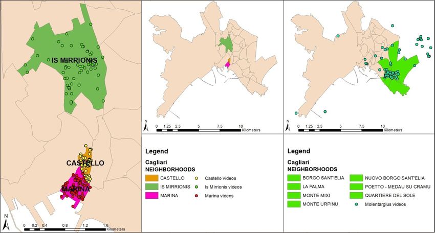
The last step of the approach has been based on the analysis of datasets extracted from YouTube for
several neighborhoods in the municipality of Cagliari (Sardinia, Italy) and the urban park of ‘Molentargius’.
The goal of the analysis is the investigation of perceptions and opinions of users on the neighborhoods and
the park area, in the light of the topics emerging by the textual analysis of videos contents. All together
these analysis are able to cover different scales of spatial planning.
In the next sections, the results of data retrieval, preliminary exploration, and spatial and textual analysis for
the different steps of the approach are proposed. The results aim to demonstrate both the capabilities of the
methodology for analysis at different scales and the opportunities for SMGI use in spatial planning.
650 TeMA Journal of Land Use Mobility and Environment INPUT 2014 Eighth International Conference INPUT - Naples, 4-6 June 2014
Smart City - Planning for Energy,
Transportation and Sustainability of the Urban SystemP. Massa, M. Campagna – Social media geographic information: recent findings and opportunities for smart spatial planning
4.3 DATA RETRIEVAL AND EXPLORATORY ANALYSIS AT THE REGIONAL SCALE
In Spatext the retrieval of contents from YouTube is performed by the YouTube Extractor tool, which allows
the collection of data by a keyword search within a given radius around a specific location. Initially, for the
purposes of the exploratory investigation, the dataset has been collected by setting the geographic area of
extraction for the whole Sardinia, while no keyword has been set to avoid any constraint in the data
extraction. The data retrieval allowed the extraction of the most relevant 3507 videos for Sardinia from
YouTube and the automatic generation of a point feature dataset, based on the location attribute stored in
the video metadata. The resulting dataset includes attributes providing information on title, author,
description, data of publication and URL link, offering opportunities for the development of further analysis
in combination with other spatial data layers.
The exploratory analysis of the dataset has been conducted through both the observation of spatial
distribution of videos in Sardinia and the tag cloud analysis of textual contents. The dataset exposed an
uniform spatial distribution over the Sardinian territory, so fostering opportunities for a general
comprehension of user contents and trends at the regional scale.
A textual analysis was also conducted on the title and on the description of videos to discover the most
frequent words in the dataset. The tag-cloud is the visualization of word frequency in a weighted list and
graphical form, and it is suitable to depict the topicalities of a text and to recognize possible underlying
information. The textual analysis searched the 200 most used words both on the titles and on the
descriptions to investigate potential dissimilarities in contents and to improve the understanding of detected
words. The resulting tag cloud shows different words for the considered textual contents, but a semantic
analysis leads toward the identification of an underlying set of common categories.
Hence, the words have been classified accordingly. Several words can be considered as ‘noise’ caused by
different languages and sentence structures, however, most of the words belongs to four main categories:
(1) toponyms/places, (2) activities, (3) values, (4) links/URL. In the first category the words referring to
specific toponyms (city name) or physical places (urban location) are considered, while in the second
category the words related to events or objects are grouped. The third category encloses the words related
to adjectives used for personal evaluation of places and events, and in last category the words relative to
external links, persons, blog or URL are enclosed.
The 5 most used words for each category are provided in the next figures and tables, respectively for text of
titles (fig. 1, tab. 1) and descriptions (fig. 2, tab. 2).
Fig. 1 Top 5 words for category in Title
651 TeMA Journal of Land Use Mobility and Environment INPUT 2014 Eighth International Conference INPUT - Naples, 4-6 June 2014
Smart City - Planning for Energy,
Transportation and Sustainability of the Urban SystemP. Massa, M. Campagna – Social media geographic information: recent findings and opportunities for smart spatial planning
CATEGORY WORDS [frequency]
Toponyms/Places Sardegna [270], Sardinia [122], Cagliari [53], Nuoro [49], Porto [41]
Activities Eventi [45], Festa [39], Ballu* [34], Carnevale [29], Rally [24]
Values Folk [25], Official [21], Verde [20], Italian [12], Lost [12]
Links/URL By [84], Of [65], On [34], To [33], wmv [28]
Tab. 1 Top 5 words for category in Title. (*) Word expressed in Sardinian language
Fig. 2 Top 5 words for category in Description
CATEGORY WORDS [frequency]
Toponyms/Places Sardegna [290], Sardinia [126], Cagliari [72], Nuoro [54], Italy [49]
Activities Music [65], Chitarra [55], Festa [51], Concerto [45], Musica [39]
Values Updated [422], Published [422], Sito [33], Beatiful [26], Great [23]
Links/URL http [1015], Youtube [756], www [612], Facebook [114], https [42]
Tab. 2 Top 5 words for category in Description
The exploratory analysis identifies several words that are used in the textual description of videos for each
category. The results explain the different typologies, purposes and trends of videos related to Sardinian
territory. On the one hand, several videos can be considered untied from physical places and exclusively
related to daily routines of users. On the other hand, several videos can be considered strictly related to
perceptions of users on events and physical places of the territory, introducing opportunities for further
analysis support.
4.4 IN SEARCH FOR ‘LANDSCAPE’ AT THE REGIONAL SCALE
The second step of the approach focuses on the spatial and textual analysis of YouTube contents related to
a specific topic of interest within a specific geographic area. For the purpose of this analysis the words
landscape and the Italian translation ‘paesaggio’ have been set as keywords for the extraction of videos in
the Sardinian territory. The keyword has been set both in English and Italian to avoid eventual lacks of
useful contents because of the language constraint. The resulting dataset contains 180 entries and allows
the investigation of locations, activities and values, which can be considered tightly related to the topic
according to user opinions. The investigation of the contents has been performed by means of tag cloud
analysis and the words have been classified according to the 4 categories. Moreover, spatial analysis were
carried on to evaluate the spatial distribution of videos. The first analysis aims to investigate potential
underlying spatial patterns or relationships between the spatial distribution of on landscape and the different
land uses expressed by the CORINE land cover. The second analysis was performed to evaluate the
652 TeMA Journal of Land Use Mobility and Environment INPUT 2014 Eighth International Conference INPUT - Naples, 4-6 June 2014
Smart City - Planning for Energy,
Transportation and Sustainability of the Urban SystemPuoi anche leggere


