"AEROSPAZIO" SPERIMENTAZIONE - CAGLIARI, 22 NOVEMBRE 2019 FRANCESCO MOLINARI - Sportello Appalti ...
←
→
Trascrizione del contenuto della pagina
Se il tuo browser non visualizza correttamente la pagina, ti preghiamo di leggere il contenuto della pagina quaggiù

SPERIMENTAZIONE
 «AEROSPAZIO»

   CAGLIARI, 22 NOVEMBRE 2019
      FRANCESCO MOLINARI
IL BANDO
H2020

CAGLIARI, 22 NOVEMBRE 2019
EGNSS APPLICATIONS FOR PUBLIC AUTHORITIES'
PILOT
SPACE-EGNSS-5-2020

https://ec.europa.eu/info/funding-
tenders/opportunities/portal/screen/opportunities/topic-details/space-egnss-
5-2020

Scadenza: 5 marzo 2020, 17:00 CET.
Budget: 3M€ destinati a 1-2 proposte al massimo.

EGNSS APPLICATIONS FOR PUBLIC AUTHORITIES'
PILOT
SPACE-EGNSS-5-2020
Specific Challenge:
Innovation procurement can drive the R&D and deployment of innovative solutions from the
demand side through respectively pre-commercial procurement (PCP). This can open new market
opportunities for companies in Europe, can contribute to speeding up public sector modernisation
and can help to tackle societal challenges with innovative/breakthrough solutions for the benefit of
the citizen.
Satellite navigation technology is an increasingly common component of innovative applications in
different market segments. Involvement of public institutions is key in fostering the EGNSS
adoption. Nowadays the maturity of EGNSS based solutions and their increased accessibility provide
significant contribution to the achievement of Sustainable Development Goals of the governments.
The main challenge of this topic is to deepen user integration and thus foster exploitation of
EGNSS applications to match the needs of public authorities at national, regional or local levels.
The innovative EGNSS solutions developed through this action should have been tested and have
demonstrated success in smaller scale settings and have not yet been deployed on a large scale.
ESEMPI DI
APPLICAZIONI

CAGLIARI, 22 NOVEMBRE 2019

EGNSS SERVICE
https://www.gsa.europa.eu/segment/egnss-service
EGNSS SERVICE
https://www.gsa.europa.eu/segment/egnss-service
What is GNSS?
Global Navigation Satellite System (GNSS) refers to a constellation of satellites providing
signals from space that transmit positioning and timing data to GNSS receivers. The receivers
then use this data to determine location.
By definition, GNSS provides global coverage. Examples of GNSS include Europe’s Galileo, the
USA’s NAVSTAR Global Positioning System (GPS), Russia’s Global'naya Navigatsionnaya
Sputnikovaya Sistema (GLONASS) and China’s BeiDou Navigation Satellite System.
GNSS performance can be improved by regional satellite-based augmentation systems (SBAS),
such as the European Geostationary Navigation Overlay Service (EGNOS). EGNOS improves
the accuracy and reliability of GPS information by correcting signal measurement errors and
by providing information about the integrity of its signals.
EGNOS SERVICE
https://egnos-user-support.essp-sas.eu/new_egnos_ops/
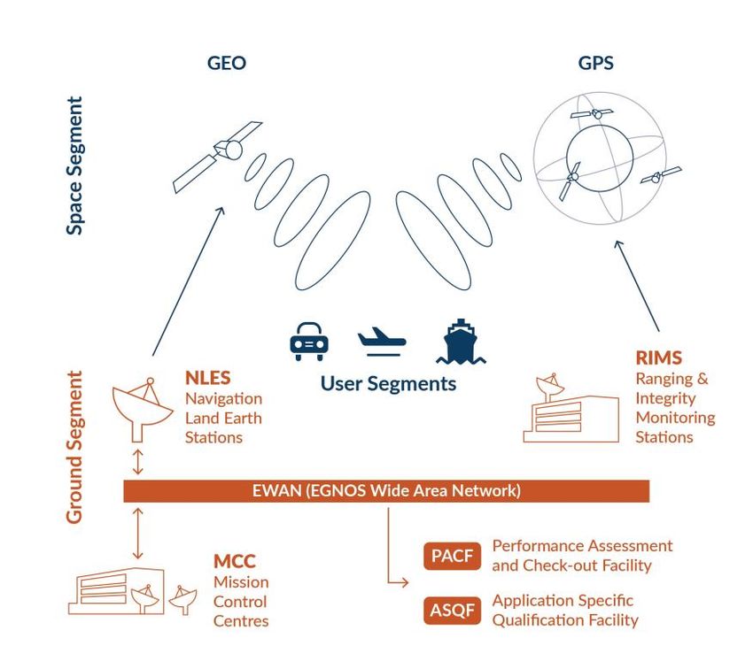
EGNOS SERVICE
https://egnos-user-support.essp-sas.eu/new_egnos_ops/
About EGNOS
The European Geostationary Navigation Overlay Service (EGNOS) is Europe's regional satellite-based
augmentation system (SBAS). It is used to improve the performance of global navigation satellite systems (GNSSs),
such as GPS and Galileo in the future. EGNOS was deployed to provide safety of life navigation services to
aviation, maritime and land-based users.
EGNOS uses GNSS measurements taken by accurately located reference stations deployed mainly across Europe
and North Africa. All measurements are transferred to a central computing centre where differential corrections
and integrity messages are calculated. These calculations are then broadcast over the covered area using
geostationary satellites that serve as an augmentation, or overlay, to the original GNSS message.
EGNOS augments the GPS L1 (1575.42 MHz) Coarse/ Acquisition (C/A) civilian signal by providing corrections and
integrity information for GPS space vehicles (ephemeris, clock errors) and most importantly, information to
estimate the ionosphere delays affecting the user . EGNOS messages are broadcast through two geostationary
satellites in compliance with applicable standards (MOPS and SARPS). The information provided by EGNOS
improves the accuracy and reliability of GNSS positioning information while also providing a crucial integrity
message. In addition, EGNOS also transmits an accurate time signal.
EGNSS SERVICE
https://www.gsa.europa.eu/segment/egnss-service
                      LOCATION
          AGRICULTURE BASED SERVICES MARITIME ROAD

     TIMING &
     SYNCHRONISATION   AVIATION   MAPPING RAIL
                                  & SURVEYING
EGNOS SERVICE
https://egnos-user-support.essp-sas.eu/new_egnos_ops/
LOCATION
AGRICULTURE BASED SERVICES MARITIME ROAD
AVIATION MAPPING RAIL
& SURVEYINGEGNSS SERVICE https://www.gsa.europa.eu/segment/egnss-service
EGNOS SERVICE
https://egnos-user-support.essp-sas.eu/new_egnos_ops/
COSA DICE LA
S3

CAGLIARI, 22 NOVEMBRE 2019
LE SFIDE (1/3)
Fonte: S3 RAS (2015)
Realizzazione di un centro regionale di valenza nazionale, presso adeguati siti
opportunamente infrastrutturati, strumentati e clusterizzati, per l’erogazione di
servizi basati sull’utilizzo delle tecnologie satellitari (GPS, Galileo e
Copernicus) e sull’utilizzo dei droni, in particolare per la prevenzione, gestione,
monitoraggio e comunicazione delle emergenze collegate al rischio
idrogeologico e agli incendi boschivi, nonché al monitoraggio delle coste e al
monitoraggio ambientale applicato all’agricoltura. L’impiego dei droni potrà
anche comportare l’utilizzo dei siti strumentati, non solo come aviosuperfici per
il decollo e atterraggio dei droni durante l’attività operativa, ma anche per i test
dei droni stessi (inclusi i payload) e per la formazione, certificazione e
addestramento del personale (piloti) coinvolto nei servizi sopracitati.
LE SFIDE (2/3)
Fonte: S3 RAS (2015)

Realizzazione di un centro di SSA (Space Situational Awareness) nazionale,
quale nodo di un più ampio framework SST (Space Situational Tracking)
europeo, per la monitorizzazione degli oggetti in orbita (satelliti e detriti
spaziali), basato sulle principali infrastrutture di ricerca e sperimentazione
presenti sul territorio regionale ·
LE SFIDE (3/3)
Fonte: S3 RAS (2015)

Sviluppo di materiali innovativi e tecnologie innovative in ambito astrofisico,
spaziale, avionico, fotonico, in particolare rivolti a:
• sistemi elettronici analogico-digitali a microonde;
• sistemi metrologici non a contatto;
• sistemi per l’esplorazione robotica e umana di Luna, Marte e Asteroidi;
• caratterizzazione di materiali alle altissime temperature;
• piattaforme unmanned (droni) e payload (sensori e sistemi di navigazione);
• materiali attivi per la fotonica.
QUALI
PROGETTUALITA’

CAGLIARI, 22 NOVEMBRE 2019
USER NEEDS AND REQUIREMENTS
https://www.gsa.europa.eu/gnss-applications/user-needs-and-
requirements
Agriculture: The new CAP update opens novel opportunities for EGNSS solutions.
Location-based Services: New applications of Augmented Reality and Robotics are envisaged.
Rail: Definition of GNSS use in rail safety relevant applications is still work in progress.
Road: The regulatory context has been updated to take into account the latest EU Regulation.
Surveying: New technology developments include: open and proprietary formats for PPP, RTK and
PPP-RTK; Open Sky vs. harsh environment; requirements table; Galileo HAS for surveying; raw
measurements on Android; and software-based GNSS and Positioning-as-a-Service techniques). The
integration of GNSS with LiDAR, RPAS, AR and other emerging technologies is also envisaged.
Time & Synchronisation: New drivers include the increasing demand for calibration of hardware
equipment delays for both scientific and industrial applications and the introduction of 5G networks
and an updated regulatory context.
VECCHIE E NUOVE PROGETTUALITA’
Fonte: S3 RAS e discussione con i partecipanti il 28 ottobre 2018

•   Sistemi e strumenti per la prevenzione, le   •   Margini di ulteriore miglioramento (es.
    gestione e la comunicazione delle                progetto Sardos / Comune di Ventimiglia)
    emergenze
                                                 •   Idem
•   Sistemi di rilevazione del territorio a
    basso costo per il monitoraggio              •   Progetti SSA SST richiedono dimensione
    ambientale                                       europea e risorse molto ingenti. Serve un
•   Metrologia, elettronica, ricevitori,             impegno politico di RAS a portare almeno
    radiotelescopio SSA SST                          una sala controllo in Sardegna
•   Servizi per il training per le piattaforme
    unmanned
•   Materiali e tecnologie per aerospazio e
    astrofisica
VECCHIE E NUOVE PROGETTUALITA’
Fonte: seminario del 24 ottobre 2018
Sistema di satelliti radar contro l’abusivismo edilizio; Utilizzo di droni per l’agricoltura di precisione, ad es.: spandimento
pesticidi, erbicidi e medicamenti, semina;
Localizzazione della sede operativa del Centro nazionale di “Space
Surveillance & Tracking” (SST) e di “Space Situational Awareness” ideazione, progettazione e realizzazione di robot che operino guidati
(SSA);
da remoto con GPS per il monitoraggio e il disinquinamento di aree
Utilizzo di dati aerei (LIDAR), satellitari (ottici e interferometrici) e dove può essere pericoloso far operare esseri umani;
batimetrici per determinare le caratteristiche topo-batimetriche e la
linea di costa delle zone più esposte al fenomeno dell’aumento del prevenzione dei rischi dovuti all’invecchiamento di impianti a rischio
livello marino (ad es. le piane costiere di Cabras e di Cagliari); di incidente rilevante - Tecniche “Aging” e “Risk Based Inspection”;
Realizzazione di analisi di subsidenza da dati satellitari (GPS e InSAR) prevenzione degli eventi Natech (Natural Hazard Triggering
e proiezioni di aumento di livello marino fino al 2100 attraverso dati Technological Disasters) in impianti RIR (Rischio Incidente Rilevante);
climatici (IPCC) e marini (mareografi e possibilmente radar altimetri);
difesa degli impianti RIR da attacchi terroristici e intrusioni;
Analisi geospaziali per ottenere scenari di allagamento marino con la
relativa estensione dell’area inondata; prevenzione incendi e incidenti in impianti di trattamento rifiuti e
Creazione di un sistema di droni “salvavita” per il trasporto sanitario stoccaggi intensivi;
di emocomponenti, organi e medicinali;
prevenzione dei rischi legati al trasporto di merci pericolose;
Utilizzo di trattori dotati di guida automatizzata mediante GPS per
l’agricoltura di precisione, ad es.: spandimento pesticidi, erbicidi e prevenzione degli eventi Natech e dei rischi di cedimenti strutturali
medicamenti, semina, fienagione, trebbiatura; nel sistema dei trasporti.IL BANDO H2020 (segue) CAGLIARI, 22 NOVEMBRE 2019
EGNSS APPLICATIONS FOR PUBLIC AUTHORITIES'
PILOT
SPACE-EGNSS-5-2020
Scope:
The objective is to launch demand-driven actions by public authorities aiming at customising EGNSS applications for
their needs. Transnational cooperation has a key role to play in this context, as it can facilitate knowledge transfer and
optimisation of resources for public authorities. Proposals should be building on procurement needs of the participating
organizations. The proposals should support the EGNSS market take-up across Europe and demonstrate a sustainability
of solutions beyond the lifespan of the proposed project. The choice of EGNSS market segment and application is left to
the proposer. A non-exhaustive list of possible applications is presented below:
  EGNSS for mobility as a service, cooperative ITS, public transport and smart cities,
  Implementation of Performance Based Navigation procedures,
  Integration of EGNSS into U-Space concept for drones,
  Helicopter emergency medical services with EGNOS capabilities (operations and equipment).
  Public rescue services with Galileo SAR capable helicopters, boats and drones
  EGNSS to support port operations,
  Monitoring of infrastructure with EGNSS (rail, road, critical infrastructure)
EGNSS APPLICATIONS FOR PUBLIC AUTHORITIES'
PILOT
SPACE-EGNSS-5-2020
Scope (foll.):
The consortium should engage public procurers from each country represented in the consortium
(at national, regional or local level) that have responsibilities and budget control in the relevant
EGNSS market segment.
Proposals should be built on the exploitation of the distinguishing features of EGNOS and Galileo
signals and operational advantages in downstream applications.
EGNSS should be part and parcel of the envisaged solution(s). However, where a combination of
EGNSS with other technologies is required to make the application(s) work, this is not excluded
from the scope.
Proposals addressing PRS (Public Regulated Service) related applications are not in the scope of this
topic.
The Commission considers that proposals requesting a contribution from the EU of between EUR 1
and 3 million would allow this specific challenge to be addressed appropriately. Nonetheless, this
does not preclude submission and selection of proposals requesting other amounts.
EGNSS APPLICATIONS FOR PUBLIC AUTHORITIES'
PILOT
SPACE-EGNSS-5-2020
Expected Impact:
Activities related to this topic should contribute to:
•    The establishment of buyer groups for EGNSS application;
•    Creation of EGNSS-enabled national, regional or local applications in support of public authorities;
•    Fostering the emergence of similar EGNSS actions in smart specialisation strategies;
•    Establishment of sustainable supply chains for delivery of downstream EGNSS applications to public
     authorities;
•    Smart use of the procurement budget to remove supplier lock-in and obtain more open, standardized and
     better “value for money” solutions;
•    Increase in quality, and decrease in prices, of EGNSS products and services;
•    Increased exploitation of IPRs and R&D results;
•    Creation of growth and jobs in Europe.
PROSSIME MOSSE
In questo incontro e nel
Idea
successivo laboratorio di progettuale
simulazione (4/12)
Nel laboratorio del 4/12 e
Fabbisogni del Enti pubblici (di
nell’eventuale proposta "pilota" almeno 3 Paesi)
sul bando H2020
Nella fase di attuazione Bandi pre-
Soluzioni Soluzioni
commerciali
del progetto H2020 EGNSS complementari
"federati"GRAZIE PER L’ATTENZIONE E LA PRESENZA I materiali di questa giornata saranno presto resi disponibili sul sito di Sardegna Ricerche, dove è possibile ricevere informazioni sui prossimi appuntamenti: http://www.sportelloappaltimprese.it/consulenza/progetto_innovazione/ Per ulteriori informazioni contattare: • email: assistenza@sportelloappaltimprese.it • gruppo LinkedIn: https://www.linkedin.com/groups/12143077/ • numero verde: 800974430
Puoi anche leggere