I servizi di Navigazione Satellitare: stato ed evoluzione - "Tecnologie e gestione del rischio: i protagonisti della mobilità integrata" - nitel
←
→
Trascrizione del contenuto della pagina
Se il tuo browser non visualizza correttamente la pagina, ti preghiamo di leggere il contenuto della pagina quaggiù
«Tecnologie e gestione del rischio: i protagonisti della mobilità
                         integrata»

              I servizi di Navigazione
                Satellitare: stato ed
                     evoluzione
                              Agenzia Spaziale Italiana
                                  Mauro Cardone

                         25 Gennaio 2017
• GPS
• Galileo
• EGNOS
• GNSS
• GNSS new applications
• GNSS evolution

                          2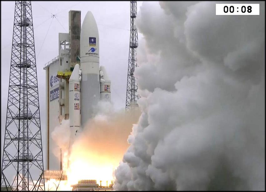
GPS motto

            3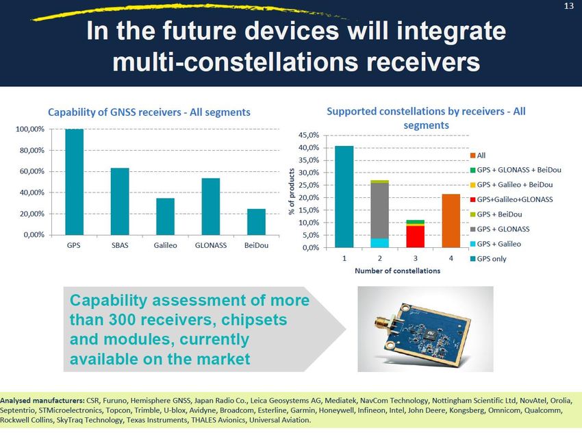
Modest Expectations

• Performance Specifications:
– Position: 10 m
– Velocity: 0.1 m/s
– Time: 100 ns
to unlimited number of users instantaneously,
continuously, in all weather, all over
• Not clear if the system could be built
– Uncertainty about the clock technology
• Number of receivers estimated as ~27,000
– Uncertainty about users and markets
• Price of a receiver estimated as ~$10 000
– Uncertainty about price

                                                4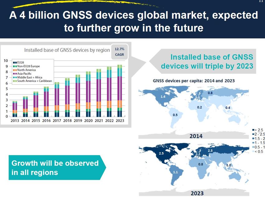
Stunning results. How Wars are now Fought

The strike
was carried
out by a
single B-2
atnight after
flying from
Whiteman
AFB
nonstop

                                                            5
6
7

8
Time error
  30 nsec
   95%

      9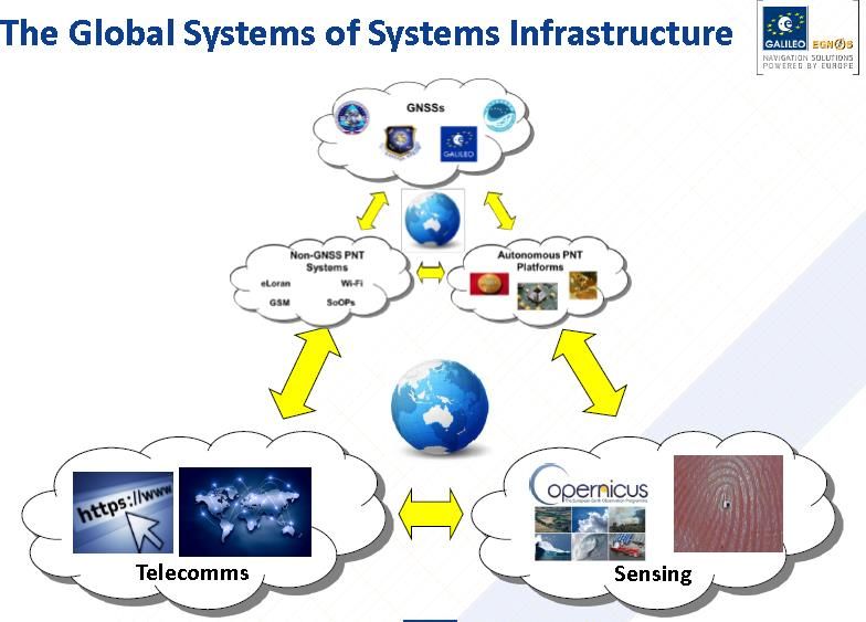
10
• GPS
• Galileo
• EGNOS
• GNSS
• GNSS new applications
• GNSS evolution

                          11
Galileo • Il sistema Galileo nasce come un programma autonomo di radionavigazione via satellite che consente all’Europa, di non dipendere completamente da paesi terzi in un campo così strategico quale è quello della navigazione satellitare. • Il sistema è costituito da una Costellazione di 30 satelliti in orbita a 23222 km d'altitudine, che copre la totalità del globo terrestre, e un Segmento terrestre che ne gestisce il controllo e la missione. • Il sistema Galileo è uno strumento essenziale per la politica di sviluppo dei trasporti (“LIBRO BIANCO — La politica europea dei trasporti”). • Galileo è un sistema civile sotto il controllo civile.
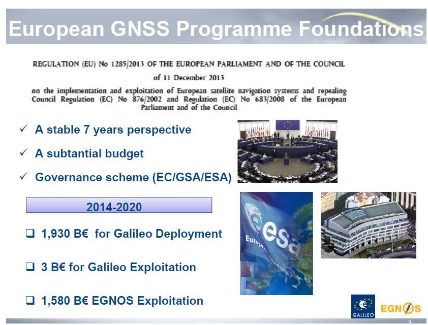
COSTO TOTALE dello SVILUPPO : CIRCA 10 BE
DURATA dello SVILUPPO: CIRCA 20 anni
                                            13
Galileo Services
Public Regulated Service (PRS) – providing:
robust and encrypted signals,
under Member States control and restricted to government-authorised
users,
for sensitive applications which require a high level of service continuity
Commercial Service (CS) – providing:
added value based upon fee payment, over the Open Service, by
dissemination of encrypted navigation related data (CS-AUTH), ranging
and timing for professional use=> now free service at 20 cm accuracy (CS-
HA)
service guarantees
Open Service (OS) – providing:
positioning, velocity and timing services, free of charge,
for mass market applications
competitive with the GPS Standard Positioning Service (SPS) and its
evolutions.
implementation of Authentication on the OS Navigation Data to support
emerging market needs is under final analysis (ON-NMA)
14Public Regulated Service
PRS provides an encrypted and robust navigation service specifically
designed to be more resistant to jamming and interference
•Primarily intended for EU Member State Governments. Also Commission,
Council and EEAS are PRS users. Potentially EU agencies, Third countries
and international organizations (under specific arrangements) can be
granted the access
–US, Norway and Switzerland have manifested their interest to have
access to PRS
•Access to the PRS is controlled through key management systems
–Users who have not been granted access to the secure features of the
PRS signal will not be able to determine any information from this signal
PRS is a governmental market
•According to Decision 1104, industry has to rely on its Member State
–To manufacture PRS material
–In addition, it has to follow a security accreditation process
–National Competent PRS Authorities are monitoring compliance with the
Common Minimum Standards ( in Italy ANPRS c/o UCI/PCM) 15SAR= Search And Rescue
16I segnali del sistema Galileo Galileo uses four bands: E1, E5, E6 and SAR band. Galileo uses four modulation schemes: BPSK, CBOC, BOC, AltBOC. Segnale concordato con GPS
Le prestazioni dei servizi del Galileo

PRS service: Not disclosed
Galileo: gli elementi principali
Space Segment
Costellazione completa di 30 satelliti MEO
TM & TC SIS
(S-Band) Up-Link Nav Message
(L-Band) (C-Band)
TT&C GSS ULS
Network Network Network
(5 stazioni) (n. 40 stazioni) (n. 9 stazioni)
Network di comunicazione (GDDN)
GCC-GCS GCC-GMS GCC-GCS GCC-GMS
GCC#1 GCC#2
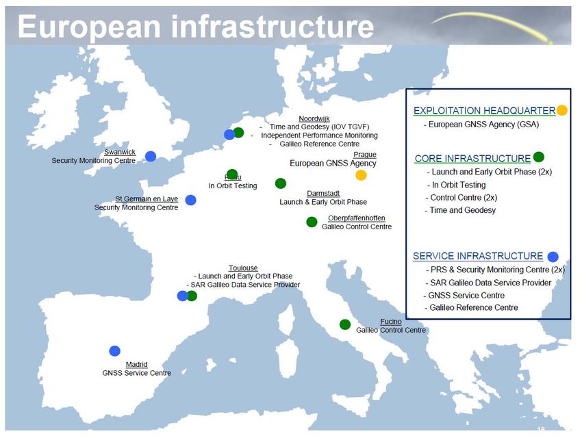
Service Facility and User SupportGalileo: i centri per la fase di erogazione dei servizi
18 satellites

                21
or under dense canopy and tunnels
----------
------------
30 nsec (95%)
2212 Dicembre 2017: Lancio di 4 satelliti Galileo(#19,20,21,22)
22 NOW!!!
23• GPS
• Galileo
• EGNOS
• GNSS
• GNSS new applications
• GNSS evolution
24EGNOS: the European SBAS
but sends corrections to users also via terrestrial links (EDAS)
Safety of Life Service certified since 2011.
Improve GPS over Europe by reporting on the reliability and accuracy
of their positioning data and sending out corrections
25EGNOS interoperability
EGNOS was designed according to the ICAO Satellite-Based Augmentation
System (SBAS) international standards. Its development was coordinated to
ensure interoperability with the world’s other SBASs:
– Multi-Functional Satellite
Augmentation System
(MSAS)
in Japan,
– Wide Area Augmentation
System (WAAS) in the USA,
– Geosynchronous
Augmented
Navigation System
(GAGAN) in
India; not yet operational.
APV: Approach with vertical guidance such as LPV 200 (not PA)
26Come funziona EGNOS
• Il segnale di EGNOS viene trasmesso da Satellite Geostazionari
che fungono da distributori del messaggio EGNOS sull’area
servita
• Il segnale EGNOS è disegnato in modo da poter essere utilizzato
dalla maggioranza dei ricevitori oggi in commercio («SBAS
enabled») come se fosse un «n+1» segnale GPS
• Con il contenuto del messaggio EGNOS il ricevitore è in grado di
calcolare la sua posizione con i seguenti miglioramenti ripsetto ad
in ricevitore solo GPS:
• Migliore accuratezza
• Integrità del segnale
• L’Integrità del posizionamento è realizzata con un sistema
complesso di monitoraggio, processamento dati realizzati nel
ground segment di EGNOS
• L’integrità permette di essere informati in tempo reale di eventuali
degradazioni delle prestazioni entro tempi brevi (time to alarm = 6
secondi per LPV-200) e secondo soglie prestabilite per il tipo di
applicazione (Protection Levels)EGNOS operations
28Architettura
active
29I Servizi di EGNOS
• EGNOS (EGNOS Versione 2) è pienamente operativo dal 2009 e fornisce i
seguenti servizi:
• Open Service (OS): per la maggior parte dei ricevitori mass market GPS
che siano anche «SBAS enabled»
• Safety of Life service (SoL): In linea con gli standard ICAO/SBAS, nato
per utilizzatori aeronautici ma utile anche in altri settori critici, richiede
ricevitori certificati nel caso «Aviation»
• Commercial Service (CS /EDAS): una innovazione nel settore dei servizi
di navigazione satellitare, fornisce dati EGNOS grezzi e processati
mediante accesso a un servizio Internet gratuito per chi è interessato a
erogare servizi a valore aggiunto (assisted SBAS)
• EGNOS timing Service (off-set rispetto a UTC e GPS time)
• EGNOS per la sua missione SoL è stato soggetto ad una Qualifica si
sistema specifica da ESA e ad una certificazione da EASAServizi EGNOS : prestazioni riscontrate
(dati ESA, 2009)LPV-200 A localiser performance with vertical guidance (LPV) is a Non precision procedure of approach and approach uses global navigation satellite system (GNSS) signals augmented by the European geostationary navigation overlay service (EGNOS), the three-satellite constellation that improves the precision of GNSS in the European area and was certified for safety of life (SoL) service in 2011. An aircraft can fly instrument approaches similar to a conventional instrument landing system (ILS) - down to a 200ft decision height (60,96 mt)-CAT I. LPV procedures do not require any new equipment at the airport which makes them an ideal low-cost alternative to increase access to secondary airports that may not be ILS-equipped on all runways. For ILS-equipped runways, the new approach design may be useful either to shorten the flightpath for certain traffic flows or simply to overlay the existing ILS and be used as a fall-back procedure in case of airborne or ground ILS equipment malfunction.
509 siti oggi in Europa predisposti per LPV-200 con EGNOS
Ancora pochi in Italia !
Problema delle procedure operative mancanti da risolvere
• GPS
• Galileo
• EGNOS
• GNSS
• GNSS new applications
• GNSS evolution

                          34
GNSS : system of navigation systems
• I sistemi di navigazione satellitari globali oggi disponibili
(ed interoperabili):
• GPS Americano
• GALILEO Europeo
• GLONASS Russo
• BEIDOU Cinese
• A questi sistemi si aggiungono i servizi regionali di
«augmentation»:
• WAAS nel Nord America e Canada
• EGNOS nell’Europa continentale e Nord Africa
• MSAS/QZSS in Giappone
• IRNSS in India
• BEIDOU/regionale in Cina
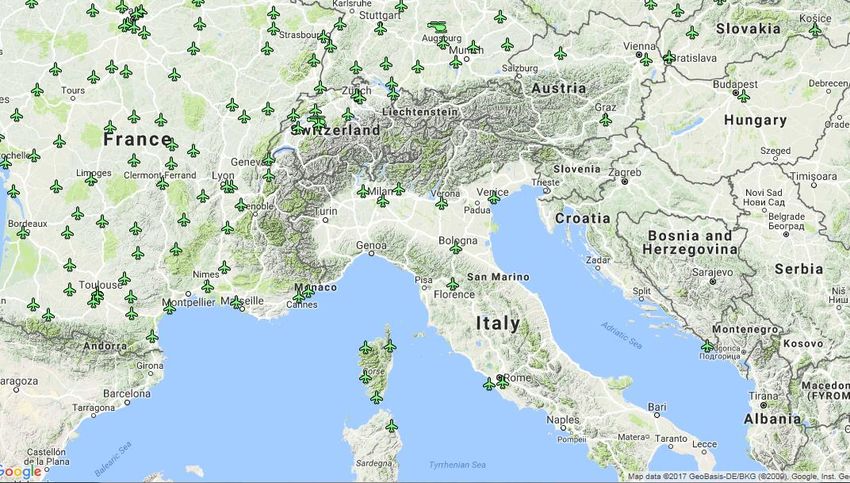
35Why multiconstellation: Global Navigation Satellite System (GNSS)
In combination with GPS, the higher number of
satellites available to the user will offer:
•Higher Accuracy
•Higher Availability
•Better Coverage
for positioning, navigation, and time (PNT)
In order to achieve this objective the GNSS systems should
ensure:
• Coexistence: Compatibility of signals, orbits and services
• Cooperation: Interoperability to allow the same receiver to
process multiple navigation messages and extract PVT
36GNSS Higher accuracy in terms of DOP
37Orbital compatibility of GNSS
Glonass 19100 km
GPS 20200 km
COMPASS 21500 km
GALILEO 23222 km
~12756 km
COMPASS 21500 kmMulti-Constellation interoperability
Navigation with GPS+GLONASS circa 1990 Galileo time=GPS+5 nsec
• Unknown time offset between GPS
Time and GLONASS Time
• Unknown GLONASS coordinate
frame (SGS 85)
=>Today Multi-Constellation Navigation
• Each GNSS requires a self-consistent
- Time Scale. All are ‘tied to’ Coordinated Universal Time (UTC)
- Coordinate Frame. Each constellation uses its own model: WGS 84, PZ-
90, GTRF, CGS2000. All are tied to ITRF, international standard
defined and maintained by IERS;
• Inter-operability requires simple, known transformations
• But why not a Unique time and coordinate frame in the future???
39• GPS
• Galileo
• EGNOS
• GNSS
• GNSS new applications
• GNSS evolution
40Billions
41GSA
source
42New challenges for GNSS :Aviation by 2023
• Performance Based Navigation ( APV/LPV-200) is driving transition from traditional
routing to GNSS navigation as SBAS based procedures availability is growing in Europe
• Multiconstellation/ Multifrequency GNSS solutions (DFMC SBAS) and ARAIM are
enabling advanced required navigation performance (RNP) , aerodrome manoeuvring,
GBAS CATII/III and space based ADS-B (Automatic Dependent Surveillance-Broadcast) for
surveillance applications through technologies like ADS-B, complementing radar technology
• GNSS enabled ELTs/ PLBs (Personal Location Beacon) are becoming essential for the
COSPAS-SARSAT Search & Rescue system. Galileo SAR is going to play a key role in aircraft
distress tracking and will enable increased performance through use of multi-constellation:
ELT-DT (Emergency location transmitter – distress tracking) using GALILEO SAR RLS
• GNSS is supporting recreational pilots using VFR (Visual Flight Rules) with moving maps,
infringements alarms and increasing also their operational awareness
• Unmanned Vehicles Systems: an emerging and promising market estimated CAGR of 52 %,
thanks to their need for precise positioning and orientation
43New challenges for GNSS : Road by 2023
•Personal Navigation Devices are going out of market. In-vehicle systems (IVS) are
growing due to more affordable prices and increasing demand for infotainment services,
which will need more reliable and accurate positioning to serve new applications.
•Publicly managed applications (e.g. eCall, Digital Tachograph, RUC-Road user charge)
will bring communication and positioning platform on all vehicles, enabling connectivity.
All cars and vans equipped with EGNOS and Galileo from 2018. All trucks will be
equipped with EGNOS and Galileo from 2019. Regulated transport will strongly
influence the evolution of GNSS, being in the centre of the navigation and positioning
solutions on the route, demanding high integrity and robustness
•Automation / Assisted driving (ADAS: ADVANCED DRIVER ASSISTANCE SYSTEMS) will
grow but based on existing platforms, first step toward autonomous vehicles. GNSS,
together with other technologies, is a key answer to Autonomous Vehicles’ need of
accurate positioning combined with reliability of localization. Accuracy would have to
be improved to decimetre level to enable full autonomous driving. Better continuity in
urban canyons would have to be ensured.
•Emerging apps. for connected vehicles combing Navigation and Telco. (e.g. 5G), for
Cooperative Intelligent Transportation System.
• Multimodal transport applications will continue using GNSS as main source of
geolocation, supported by indoor means for relative positioning(Ubiquitous positioning)
44AUDI A8 level 3 : traffic jam pilot
Tesla level 2
45New challenges for GNSS : Rail by 2023
•Growing interest in GNSS use for rail applications. Passenger information system is the
main application.
•GNSS systems are still predominantly used for non-safety related applications. Safety
related GNSS systems are expected to complement traditional rail technologies.
•The use of GNSS for signalling and train control will generate benefits for the whole
rail industry (e.g. PTC is already starting to influence the US industry core revenue).
GNSS begins to be implemented also for safety relevant applications with different
maturity depending on the region, e.g. in India, China and the Middle East. OPEX
savings in comparison with legacy systems will play a major role in driving future
demand for GNSS
•Integrity level of GNSS, not meeting today the required level for many safety-critical
applications such as train positioning, would need to be improved.
•Emerging applications combining Positioning and Navigation with Earth Observation
data for asset management
46New challenges for GNSS : Maritime by 2023
• For Regulated vessels multi constellation GNSS receivers are in the centre of
proposed Multi-system receiver under e-navigation concept. OS Galileo to be
added in the maritime receivers.
• In regulated segment General Navigation and SAR (EPIRB: Emergency Position
Indicating Radiobeacon or PLB) have the largest share in GNSS receiver shipment.
SOLAS (Safety of Life at Sea (US DoD)) and non-SOLAS vessels are in use. Galileo SAR
to be used widely for SAR.
• Manoevring operations in port will get benefit from high precision positioning.
EGNOS V3 to complement DGNSS.
• Recreational and Leisure is by far the larget application in terms of number of GNSS
devices
47The future: Smart Car and the Smart Cities
m
48More than support to mobility
&Smart Mobility
…and more: LBS crowdsourcing for user generated contents,
precision farming and robots for future farming
surveing, construction and cadastral
etc
49How we get there? What we need from GNSS?
• More accurate, reliable, available positioning and navigation for
UAVs and autonomous cars
• More accurate timing for telecom and DVB
• Ubiquitous positioning for IOT, LBS and multimodal logistics
• Mass communication for emergency warning ( by telecom link to
consumer and not only by a specialized beacon)
• More accurate vessels positioning for port access and manoevering
• More accurate positioning for big data
• Integrity for safety critical and liability critical transport for rail,
road, and m-health.
50• GPS
• Galileo
• EGNOS
• GNSS
• GNSS new applications
• GNSS evolution
51Selective Availability Anti-spoofing Module
52New signals for GPS
The USG commits to maintaining the existing GPS L1 C/A, L1 P(Y), and
L2 P(Y) signal characteristics that enable codeless and semi-codeless
GPS access until at least two years after there are 24 operational
satellites broadcasting L5. (no earlier than 2020-2025)
53Galileo Mission Evolution (G2G)
Dal 2014 è stata elaborata a livello comunitario una GNSS Mission Evolution
Roadmap (EGMER) con l’obiettivo di costituire un processo strutturato per la
definizione dei requisiti di missione della prossima generazione di Galileo (G2G).
G2G è basato oggi su un nuovo baseline della Commissione Europea (HLD) e nuovi
requisiti di missione e di sicurezza (GMRD, SSRS) emessi da ESA.
• La tempistica è la seguente:
Lancio del primo satellite al 2025
Fase di approvvigionamento satelliti: 5 anni
Fase di definizione Missione / Sistema : 2 years
54European GNSS Evolution (HLD, issue 1.1, 20 September 2016)
Three evolution scenarios are considered
- Scenario 1 targets first level improvements in navigation capacities; position and
timing accuracy and availability are improved for a use in difficult environment, such
as cities, to meet the demand of urban users and assets. A Timing service is newly
introduced to answer the synchronisation requirements of a wide variety of strategic
applications and infrastructures. The service volume of the Open service is also
extended to allow the use of its signals for navigation purposes by assets (satellites,
orbital stations) located up to LEO orbits.
- Scenario 2 goes in the same direction and continues improving the navigation
performance, with a specific focus on smart mobility and transport. It introduces
improvements in time to first fix, continuity, integrity and authentication. Specific
changes affect also the provision of navigation services for space users (then extended
to GEO users) and for the Search and Rescue community. Navigation and timing
performance is expected to be attained under more stringent conditions, i.e. under
higher level of multipath and interference.
55European GNSS Evolution (HLD, issue 1.1, 20 September 2016)
- Scenario 3 targets sub-meter accuracy with continuous improvements all over the
performance indicators, thus answering the requirements of high-demanding
applications such as autonomous vehicles and energy or telecommunication networks.
In addition, ARAIM is further developed by proposing that the integrity message is
generated and monitored by the system itself; the Search and Rescue community sees
the introduction of a two-way communication capability to allow the exchange of
short messages, and the timing service is made even more accurate for higher level of
synchronisation. Such high performance is also to be attained under more stringent
conditions, including at high dynamics.
56EGNOS V3- Dual Frequency Multi-Constellation (DFMC) The next generation of EGNOS (EGNOS v3) will continue to offer this legacy service and will offer 2 (two) additional features: • it will augment the Galileo positioning service (i.e. Dual Constellation capability with GPS and Galileo OS) • and will provide correction data and integrity information with a second signal in the GPS L5 and Galileo E5a frequency band (i.e. Dual Frequency capability in the L1/E1 and L5/E5a frequency bands). These features will increase the robustness of the service and improve the performance provided to users for navigation services, notably in terms of positioning accuracy. Moreover the service area will be extended to geographical areas contiguous to Europe.
As implemented currently in aircrafts, Receiver Autonomous Integrity Monitoring
(RAIM) only supports lateral navigation. In order to cover vertical guidance
worlwide, Advanced RAIM (ARAIM) techniques were recommended to include:
    •Frequency diversity (e.g. using dual frequency measurements on L1/L5 for
    GPS),
    •Geometry diversity (e.g. using as many GNSS constellation as possible in
    order to reach the required levels of satellite availability),
    •Use of an Integrity Support Message (ISM) that would convey safety
    assertions associated with each of the core GNSS to the sovereign
    responsible for a given airspace,

The provision of integrity data for both GPS and Galileo G2G open signals
for ARAIM will be ensured through EGNOS (version 4?) -2035 !.

                                                                           58
Beyond APV/LPV-200 SBAS systems are aiming at providing integrity down to the LPV-200 level. LPV-200 is a newly introduced approach mode that provides lateral performance with vertical guidance down to a decision height of 200 feet. As of today, GBAS (such as DGNSS based LAAS) is the only GNSS-based system that can provide the integrity performance necessary for precision approaches (up to CAT-III). However, civilian airports have rarely implemented GBAS, which does not provide the advantages of a reduced ground segment that SBAS does. In the future adding multiple constellations (EGNOS V3) and the use of ARAIM may allow for CAT-I precision approach conditions to be reached w/o GBAS.
Future GNSS : the System of systems 2.0

                       GNSS WORLD: system of system 1.0
                        MCMF     ABAS

                SBAS
                        GBAS
                                        MICRO-TECHNOLOGY FOR POSITIONING, NAVIGATION AND
                                        TIMING (MICRO-PNT)

                                                   DARPA's “timing & inertial measurement unit

                                                                 Chip-Scale Atomic Clocks (CSAC)

       WI-MAX

3G, 4G, 5G
                                                         Improved EGI: Embedded GNSS and INS

                                                            Better MEMs sensors, Atomic
                                                        reference mass accelerometers &
                                                      gyros (“cold atoms interferometry”)
Future GNSS : the System of systems 3.0
-Disaster recovering
-5g ubiquitous positioning
-Drone Survey
-telecom syncronization
-Geodetic surveillance
- Alert and warning system,….
-Maritime surveillance,….
Remote
61Q&A
Grazie, enjoy your navigation !
For more information:
Mauro Cardone
Agenzia Spaziale Italiana
mauro.cardone@asi.it
62Puoi anche leggere