2019 IL CAPITALE CULTURALE - Studies on the Value of Cultural Heritage - UniMC
←
→
Trascrizione del contenuto della pagina
Se il tuo browser non visualizza correttamente la pagina, ti preghiamo di leggere il contenuto della pagina quaggiù
19
IL CAPITALE CULTURALE
                        2019
Studies on the Value of Cultural Heritage
 eum          Rivista fondata da Massimo Montella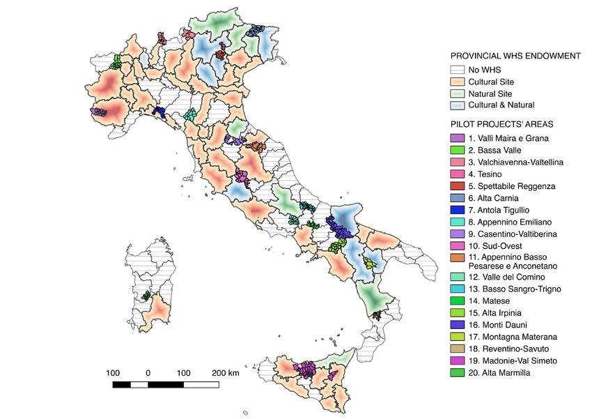
Il capitale culturale                                Gaetano Maria Golinelli, Xavier Greffe, Alberto
Studies on the Value of Cultural Heritage            Grohmann, Susan Hazan, Joel Heuillon,
n. 19, 2019                                          Emanuele Invernizzi, Lutz Klinkhammer,
                                                     Federico Marazzi, Fabio Mariano, Aldo M.
ISSN 2039-2362 (online)                              Morace, Raffaella Morselli, Olena Motuzenko,
                                                     Giuliano Pinto, Marco Pizzo, Edouard
Direttore / Editor                                   Pommier †, Carlo Pongetti, Adriano Prosperi,
Massimo Montella †                                   Angelo R. Pupino, Bernardino Quattrociocchi,
                                                     Mauro Renna, Orietta Rossi Pinelli, Roberto
Co-Direttori / Co-Editors                            Sani, Girolamo Sciullo, Mislav Simunic,
Tommy D. Andersson, Elio Borgonovi,                  Simonetta Stopponi, Michele Tamma, Frank
Rosanna Cioffi, Stefano Della Torre, Michela         Vermeulen, Stefano Vitali
di Macco, Daniele Manacorda, Serge Noiret,
Tonino Pencarelli, Angelo R. Pupino, Girolamo        Web
Sciullo                                              http://riviste.unimc.it/index.php/cap-cult
                                                     e-mail
Coordinatore editoriale / Editorial Coordinator      icc@unimc.it
Giuseppe Capriotti
                                                     Editore / Publisher
Coordinatore tecnico / Managing Coordinator          eum edizioni università di macerata, Centro
Pierluigi Feliciati                                  direzionale, via Carducci 63/a – 62100
                                                     Macerata
Comitato editoriale / Editorial Office               tel (39) 733 258 6081
Giuseppe Capriotti, Mara Cerquetti, Francesca        fax (39) 733 258 6086
Coltrinari, Patrizia Dragoni, Pierluigi Feliciati,   http://eum.unimc.it
Valeria Merola, Enrico Nicosia, Francesco            info.ceum@unimc.it
Pirani, Mauro Saracco, Emanuela Stortoni,
Federico Valacchi                                    Layout editor
                                                     Roberta Salvucci
Comitato scientifico - Sezione di beni
culturali / Scientific Committee - Division of       Progetto grafico / Graphics
Cultural Heritage                                    +crocevia / studio grafico
Gi use ppe Ca pr io tti, M a r a C e r q u e tti,
Francesca Coltrinari, Patrizia Dragoni,              Rivista accreditata AIDEA
Pierluigi Feliciati, Maria Teresa Gigliozzi,         Rivista riconosciuta CUNSTA
Susanne Adina Meyer, Massimo Montella †,             Rivista riconosciuta SISMED
Umberto Moscatelli, Sabina Pavone, Francesco         Rivista indicizzata WOS
Pirani, Mauro Saracco, Emanuela Stortoni,            Rivista indicizzata SCOPUS
Federico Valacchi, Carmen Vitale                     Inclusa in ERIH-PLUS

Comitato scientifico / Scientific Committee
Michela Addis, Tommy D. Andersson, Alberto
Mario Banti, Carla Barbati, Sergio Barile,
Nadia Barrella, Marisa Borraccini, Rossella
Caffo, Ileana Chirassi Colombo, Rosanna
Cioffi, Caterina Cirelli, Alan Clarke, Claudine
Cohen, Lucia Corrain, Giuseppe Cruciani,
Girolamo Cusimano, Fiorella Dallari, Stefano
Della Torre, Maria del Mar Gonzalez Chacon,
Maurizio De Vita, Michela di Macco, Fabio
Donato, Rolando Dondarini, Andrea Emiliani †,
The management of cultural heritage and landscape in inner areas edited by Mara Cerquetti, Leonardo J. Sánchez-Mesa Martínez, Carmen Vitale
Guardo le canoe che fendono l’acqua, le barche
                                          che sfiorano il campanile, i bagnanti che si
                                          stendono a prendere il sole. Li osservo e mi sforzo
                                          di comprendere. Nessuno può capire cosa c’è sotto
                                          le cose. Non c’è tempo per fermarsi a dolersi di
                                          quello che è stato quando non c’eravamo. Andare
                                          avanti, come diceva Ma’, è l’unica direzione
                                          concessa. Altrimenti Dio ci avrebbe messo gli
                                          occhi di lato. Come i pesci1.

                                          Quando cammino nei prati attorno al Santuario,
                                          quasi sempre solo, ripenso a nonno Venanzio che,
                                          da giovane biscino, pascolava il gregge negli stessi
                                          terreni. Mi affascina il fatto che in questo luogo
                                          la cui cifra, agli occhi di chi guarda adesso la mia
                                          scelta di vita, è la solitudine, nei secoli addietro
                                          abitassero oltre duecento persone. Ancora negli
                                          anni Cinquanta, ricorda mio nonno, erano quasi
                                          un centinaio gli abitanti di Casette di Macereto
                                          tra contadini, mezzadri, mogli, pastori e un
                                          nugolo di bambini che costringeva il maestro
                                          a salire ogni giorno da Visso per fare lezione a
                                          domicilio.
                                          Era una comunità compatta, coordinata come
                                          lo può essere quella delle società operose degli
                                          insetti: api, formiche, tremiti, ma cosa più
                                          sorprendente che mai, una comunità niente
                                          affatto statica o chiusa2.

1   Balzano M. (2018), Resto qui, Torino: Einaudi, p. 175.
2   Scolastici M. (2018), Una yurta sull’Appennino, Torino: Einaudi, p. 50.
Di Matteo D., Cavuta G., Inner Areas and UNESCO World Heritage: what possible convergences?
«Il capitale culturale», n. 19, 2019, pp. 83-108
ISSN 2039-2362 (online); DOI: 10.13138/2039-2362/1910
Inner Areas and UNESCO
World Heritage: what possible
convergences?*
Dante Di Matteo**, Giacomo
Cavuta***
Abstract
This paper constitutes an exploratory study about the possible relationships between
Inner Areas and World Heritage Sites in Italy. For each pilot project area individuated by
SNAI, it was designed a potential tourism gravitational basin, by taking into account the
average yearly nights spent of all the neighboring provinces with WHS endowments, for
the 12-year period 2005-2016. General results show that the central-northern pilot areas
are more willing to intercept cultural heritage flows, while the majority of southern areas
are significantly far from possible convergences with UNESCO place markers. Descriptive
statistics and synthetic cartographic representation of potential tourism gravitational basins
are provided, policy implications are discussed.
* The §§ 3, 4, 5 and 6 are to be attributed to Dante Di Matteo, §§ 1 and 2 to Giacomo Cavuta.
** Dante Di Matteo, Research Fellow in Applied Economics, Politecnico di Milano, Diparti-
mento di Architettura e Studi Urbani (DAStU), Piazza Leonardo da Vinci, 32, 20133 Milano, Italy,
e-mail: dante.dimatteo@polimi.it.
*** Giacomo Cavuta, Associate Professor of Economic Geography, University “G. d’Annun-
zio” of Chieti-Pescara, Department of Economics (DEc), Viale Pindaro, 42, 65127 Pescara, Italy,
e-mail: giacomo.cavuta@unich.it.84 DANTE DI MATTEO, GIACOMO CAVUTA
Questo lavoro costituisce uno studio esplorativo circa le possibili relazioni tra Aree
Interne e Siti del Patrimonio UNESCO in Italia. Per ciascuna delle aree del progetto pilota
individuate dalla SNAI è stato disegnato un potenziale bacino gravitazionale di utenza
turistica, prendendo in considerazione la media annuale delle presenze turistiche delle
province confinanti e aventi sul proprio suolo almeno un sito UNESCO, per un periodo di
12 anni dal 2005 al 2016. I risultati generali mostrano che le aree pilota del centro-nord
Italia sono più predisposte ad intercettare flussi turistici culturali, mentre la maggior parte
delle aree del sud sono significativamente distanti da possibili convergenze con i marcatori
territoriali dell’UNESCO. Si forniscono le statistiche descrittive e una rappresentazione
cartografica sintetica dei potenziali bacini gravitazionali, si discutono inoltre le principali
implicazioni politiche.
1. Introduction
The early debates around inner areas date back to the late seventies1,
when the concept was mainly used for describing the shift processes from a
metropolitan industrial structure to a more mobile manufacturing industrial
system, in which the “outer” areas did gain benefits from this “net shift”
process2. Later, the concept was extended also to the rural peripheral areas
characterized by a significant geographical distance from major centers and by
substantial phenomena of depopulation, highlighting the role of emerging rural
clusters for improving innovation in small and medium-sized enterprises3. The
tourism industry did not stay exempted from the concerns about the peripheral
areas and, already during the two decades of the late nineties and the early
2000s, literature has contributed with several works examining the role of
tourism for the development and recovering of peripheral and inner areas4.
The recent institution of the Technical Committee for the Inner Areas in
Italy has reiterated the problem of the significant spatial distance – in terms of
development levels, accessibility to main services and lack in infrastructures –
from the major centers to the peripheral destinations in Italy, giving birth to the
National Strategy for the Inner Areas (SNAI)5. While not having been recognized
as a primary objective in the early plan documents, tourism development in
Inner Areas has progressively obtained an important weight in local strategies’
planning. Several regions, with the related local areas’ managers, have focused
on the role of local cultural heritage and the community-engagement in tourism
planning. In a national context where the cultural heritage has been the object
of interest of worldwide protection programs deriving from the UNESCO
1 Cheshire 1979.
2 Lloyd 1979.
3 Virkkala 2007.
4 Wanhill 1997; Brown, Hall 2000.
5 Barca et al. 2014.INNER AREAS AND UNESCO WORLD HERITAGE: WHAT POSSIBLE CONVERGENCES? 85
convention of 1972, and it has resulted in 54 active sites currently posed under
the World Heritage List (WHL), it is necessary to understand what possible
intersections between the Inner Areas and those World Heritage Sites (WHS)
areas already developed, in terms of tourism maturity, could be significant for
each other.
For these reasons, this work starts with a general review of the concept of
peripherality in tourism and then this last is applied to the Italian scenario,
understanding the role of SNAI in tourism development for Inner Areas. In
a further moment, the main characteristics for managing a World Heritage
Site are discussed, with particular reference to the role of local communities in
the process of building a local strategy. The last step concerns the comparison
between the Pilot Project Areas, individuated by the SNAI technical committee,
and the already established tourism flows answerable to the Italian provinces
involved in UNESCO protection programs. This will lead to the construction of
a descriptive map, in which are highlighted – for each Pilot Area – the potential
tourism gravitational basins coming from the neighboring provinces with WHS
endowments.
Although this work cannot be considered as exhaustive for understanding
if there are potential linkages between peripheral areas and the tourism flows
generated by world heritage destinations in Italy, it can constitute an attempt
to track preliminary considerations about synergies, sharing and joint planning
within and beyond the boundaries of Inner Areas.
2. Tourism in peripheral areas: the theoretical background
Peripherality has been traditionally associated with specific rural functions
as agriculture, sparsely populated areas, geographically dispersed settlement
patterns6. Over the decade of the 1990s, in Europe, tourism has started to assume
a key role in facing social and economic challenges of peripheral and rural
areas, especially for territories under traditional agrarian industrial decline7.
In peripheral communities, tourism could represent one of the few tools for
creating development opportunities8 and the networking between the public
tourism planner and stakeholders (firms of any size in various combination)
may help the recovering of regional economies and the economic restructuring
of peripheral and rural areas9.
6 Hall, Page 2006; Cloke 1992.
7 Opperman 1996; Williams, Shaw 1998; Baum, Hagen 1999; Sharpley 2002.
8 Getz, Frisby 1988; Müller, Jansson 2007; Hall 2008.
9 Butler et al. 1998.86 DANTE DI MATTEO, GIACOMO CAVUTA
Not only the decline of industrial systems, but other several reasons could be
identified behind peripherality and they can assume the contours of “barriers”
to the tourism development. For example, for what concerns economic barriers,
some authors10 discussed the low structure of local supply in regards to tourism
development in peripheral areas, while others11, next to the agricultural-
based industry decline, have identified some features for peripheral areas
looking for tourism development and diversification, such as: spatial distance
from endowments of necessary resources, slow adapting to tourism changing
economic circumstances, low funding capacity and consequently employment
flattening in smaller local communities, lack and denial towards innovation
capacity and technology adaptation, uncompetitive SMEs if compared to core-
areas’ firms.
Climatic conditions, difficult in accessibility12 and geo-morphological
characteristics can be listed among other main reasons for peripherality. Such
orographic barriers often lead to seasonality13, which frequently affects the
demand-side of the tourism industry and the issue of seasonality is frequently
noticeable especially in peripheral areas. In these terms, literature has
individuated a series of key reasons, such as: periods of inaccessibility or un-
hospitability due to weather conditions; high distances from major population
centers and lack of local consumer market for short-breaks or city-trips to key
attractions; priority of other economic sectors that may overshadow tourism
activities; reticence of local operators regarding the less profitable periods that
can influence third parts due to a finite system-wide capacity, and other external
structural impediments for jurisdictional reasons. In case of islands’ peripheral
areas, the problem of seasonality can be even amplified by access problems due
to time, reliability and cost, or due to specific labor markets or political and
macro-economic issues which can invalidate early tourism purposes14.
In terms of organizational barriers, peripheral destinations, due to their
weaknesses in marketing, management, planning and resources, are increasingly
forced to follow the instructions of vertical-hierarchical multinational
corporations, boosting their overdependence upon conventional distribution
channels, reducing the uniqueness for increasing and reinforcing tourism
effects on local economies15. However, under some circumstances (increasing
of accommodation capacity, stimulating the tourists’ novelty-seeking behavior
etc.) peripheral areas could benefit from the preference of people from central
areas, who are usual to prefer spending their recreational time in periphery, as
10 Zhang et al. 2007.
11 Wanhill 1997.
12 Hohl, Tisdell 1995.
13 Connell et al. 2015.
14 Baum, Hagen 1999.
15 Buhalis 1999.INNER AREAS AND UNESCO WORLD HERITAGE: WHAT POSSIBLE CONVERGENCES? 87
in the case of Israel16. Anyway, although the best efforts are commonly headed
to reinforcing accommodation structure development, it is unavoidable to
pay attention also to the motivational factors necessary to encourage visitors
towards peripheral destinations, such as in the Book Town case17.
It is not negligible to highlight that all these kinds of barriers produce as their
first effect the issues of depopulation and socioeconomic decline of the peripheral
area concerned. In the view of recovering destinations affected by peripherality,
already remote literature has recognized in tourism a possible and practicable
leverage to stimulate or re-engage local communities’ development. In the early
seventies, as a possible line of development of the remote and depopulated
rural area of North Norfolk (England), the establishment of recreational
facilities along the coast was assumed, in an area which was characterized by a
considerable natural endowment, but in which no tourism plans were designed
before18. Shortly after, in a review of the primary needs regarding the rural
depopulated territories of the Irish country, it was underlined that tourism
was supposed to be an integral part of regional and local development plans,
predicting that the expansion of tourism activities was considered as essential for
readdressing the future of rural areas in Europe19. The centrality of tourism in
regional planning was reaffirmed in the case of Sweden, where, by reviewing the
regional development policy undertaken by the Swedish government in regard
to the northern peripheral areas of the country, it was noted that the integration
between development policies and tourism activities was reached only after two
decades of implementation. In particular, it was claimed that possibilities for
local communities become real opportunities only when people, entrepreneurs
and planners are involved and aware of the cultural heritage endowment of their
area20. Tourism development was revealed to be functional also in some very
remote regions of Australia among the middle of the nineties, where the majority
of the inner areas experienced a strong depopulation against the powerful
population growth of the coastal areas21. In Japan, the “revitalization” of the
three rural depopulated communities of Tsumago, Shiojiri and Yufuinhas has
passed through the development of tourism, where local politics gave emphasis
on cultural traditions, religious belief and helped the restoring of many old
structures for reconverting them into tourism attractions22. More recently, the
same concept of revitalization of rural communities was discussed in regard to
the Italian scenario, where through an analysis of a series of projects applied to
16 Krakover 2004.
17 Seaton 1999.
18 Drudy, Wallace 1971.
19 Commins 1978.
20 Nilsson 1993.
21 Mckenzie 1994.
22 Sullivan 1997.88 DANTE DI MATTEO, GIACOMO CAVUTA
Italian peripheral depopulated destinations, it was found that restoring cultural
assets has led to new tourism opportunities for the villages concerned23.
A particularly evident common trait which comes up from all the above-
discussed cases is that tourism development of a peripheral destination cannot
avoid the linkage existing between the local community and the cultural
heritage. In other terms, especially for those territories affected by problems of
depopulation, the revitalization of local economy may begin when residents get
conscious and aware about their territory, playing an active role in the decision-
making processes. In this framework, the local and regional governmental
bodies should be able to plan policies aimed, at the same time, to valorize
cultural or natural endowment, maximize social and economic benefits for
local communities and – last but not least – ensure the integrity of available
resources.
3. Peripherality in Italy. The SNAI’s role in tourism development
The marginalization phenomena of Italian “Inner Areas” started around the
1950s (after World War II) and the reasons at the basis of this decline24 follow the
above mentioned literature25, with particular reference to: population decline,
jobs cut and falling land use, shortage in public and private services, social
costs, hydro-geological instability, degradation of cultural and natural heritage,
lack of funding by local administrations, aversion of local communities towards
outside intervention. The expression “Inner Areas” summarizes the feature of
limited accessibility to essential services of all residents of “minor centers” in
Italy. For this reason, 3 main characteristics of the Inner Areas are:
–– significant spatial distance from main “service centers” (education,
health, mobility);
–– abundance of environmental (water, agricultural, forests, natural and
human landscape) and cultural resources (abbeys, archaeological assets,
museums, historic settlements, skills centers);
–– high differentiation between endowments of each area, due to the
temporal stratification and differentiation of natural and anthropological
systems.
Over times, public and private bodies have extracted – wrongly – a large
amount of resources (biomass plants, wind farms, cables, landfill), gaining
significant revenues in the short term, but not producing benefits and innovations
23 Di Figlia 2016.
24 Barca et al. 2014, p. 10.
25 Cloke 1992; Wanhill 1997; Baum, Hagen 1999.INNER AREAS AND UNESCO WORLD HERITAGE: WHAT POSSIBLE CONVERGENCES? 89
in the long term for local communities26. In order to map geographically the
Inner Areas, the National Strategy has adopted a distance-based approach
(travel-time), measuring the distance between the Inner Areas and the “service
centers”, as follow:
–– single-municipality service center (urban centers);
–– multi-municipality service center;
–– belt areas (up to 20 minutes far from the centers);
–– intermediate areas (from 20 to 40 minutes far from the centers);
–– peripheral areas (from 40 to 75 minutes far from the centers);
–– ultra-peripheral areas (over 75 minutes far from the centers).
“Service centers” are the municipalities with the following structural
endowment27: exhaustive range of secondary schools; at least one highly
specialized hospital; at least one silver-type railway station. Municipalities falling
into the Inner Areas in Italy are 4,185, among which 2,360 are intermediate
areas, 1,522 are peripheral areas and 303 are ultra-peripheral areas, representing
the 51.7% of the whole municipalities. In terms of average elevation, Inner
Areas range from 400 to 670 meters on the sea level in average; as for the
population, Inner Areas represent about 23% of the national population, with
about 13 million people living in between intermediate, peripheral and ultra-
peripheral areas; in terms of national surface, almost 60% of the whole surface
is involved into Inner Areas perimeters; the most of “belt areas” are located in
the northern Italy, while the majority of “ultra-peripheral areas” can be found
in Basilicata and Sardinia; approximately 65% of Inner Areas corresponds to
mountain municipalities28.
These municipalities have been clustered in 72 inter-municipal areas, 56
of which have already set out a path for being formally recognized as Inner
Areas29. In order to pick up fast feedbacks about the effectiveness of the SNAI
strategy, for each region has been identified one pilot project area, upon which
early assessment will be conducted. The pilot project areas are summarized
in table 1, and they will be considered in this study as gravitational poles for
understanding what the potential basins of tourism flows – deriving from
WHS provinces – are able to be intercepted for boosting the growth of local
communities.
26 Barca et al. 2014, pp. 10-11.
27 Lucatelli 2015.
28 Capece Galeota 2015.
29 Andreoli et al. 2017, p. 2.90 DANTE DI MATTEO, GIACOMO CAVUTA
N° Pilot project area Region Province(s) Number of
involved
municipalities
Valli Maira e
1 Piedmont Cuneo 18
Grana
2 Bassa Valle Valle d’Aosta Aosta 22
Valchiavenna-
3 Lombardy Sondrio 18
Valtellina
Trentino Alto
4 Tesino Trento 3
Adige
Spettabile
5 Veneto Vicenza 8
Reggenza
Friuli-
6 Alta Carnia Udine 21
Venezia-Giulia
7 Antola Tigullio Liguria Genova 16
Appennino Emilia- Reggio
8 10
Emiliano Romagna nell’Emilia
Casentino-
9 Tuscany Arezzo 10
Valtiberina
10 Sud-Ovest Umbria Terni 20
Appenino Basso Pesaro-
11 Pesarese and Marche Urbino and 10
Anconetano Ancona
Valle del
12 Lazio Frosinone 18
Comino
Basso
13 Abruzzo Chieti 33
Sangro-Trigno
14 Matese Molise Campobasso 14
15 Alta Irpinia Campania Avellino 25
16 Monti Dauni Puglia Foggia 29
Montagna
17 Basilicata Matera 8
Materana
Reventino
18 Calabria Catanzaro 14
Savuto
Madonie- Palermo and
19 Sicily 24
Val Simeto Catania
20 Alta Marmilla Sardinia Oristano 20
Tab. 1. Pilot project areas in SNAI strategy (Source: SNAI plan documents, 2016)
These pilot project areas are asked to develop a cohesive local strategy, in
order to improve the use of territorial milieu, enhance residents’ well-being and,
definitively, reduce the issues of depopulation and marginalization through an
increased level of place attractiveness30. In order to pursue these primary goals,
these areas will benefit from funding coming from the most common European
30 Ibidem.INNER AREAS AND UNESCO WORLD HERITAGE: WHAT POSSIBLE CONVERGENCES? 91
structural funds, where each region organizes the allocation basing on its own
planning tools31.
The importance of tourism for recovering peripheral areas has been pointed
already from the early document of SNAI strategy. Despite this, the relevance
of tourism development was slight and tourism was only mentioned among
the categories involved for local development projects, but without any kind
of particular deepening. Indeed, tourism was only seen as a natural, cultural
or sustainable resource to be valorized, without lines of interventions. In the
first SNAI technical report32, tourism perspectives were still weak in policies
and governmental guidelines. As noted in a following study through a content
analysis of plan documents, cross-references to tourism activities and natural
environments were identified as cohesive in a cluster, but still “non-specific”33.
Different are the results of the second SNAI technical report34, where tourism
assumes more relevance, in terms of driving force for local development,
investment measures, governance model, methodological methods for applying
tourism-related strategies, innovative and sustainable vision, cultural heritage
valorization, professional education. MiBACT (renamed as MiBAC after the
forming of the government on June 1, 2018), at this purpose, set up a guideline
for tourism development.
The question of tourism development in Inner Areas assumes different
extents, depending on the tourism degree of development already held by
the area concerned. On this matter, a recent technical note to Inner Areas35
has pointed that pilot project areas are developing strategies basing on two
general lines of action: the first is concerned to those areas whose tourism can
already be classified as “mature”, while, as for the second ones, are concerned
those areas categorized as “emerging” tourism markets. The heterogeneity
of tourism structures in distinct areas requires appropriated and well-defined
different strategies, depending on whether the area concerned is experiencing
an expansion or a maturity phase of its tourism life cycle. When referring to the
tourism destination life cycle, we are considering as starting point the theory
elaborated by Richard Butler in 1980, the so-called “Tourist Area Cycle of
Evolution”36, with which the author reconsiders and applies the Product Life
Cycle theory to the tourist areas and extends the number of stages previously
theorized by Walter Christaller37, i.e. discovery, growth and decline. Under
this theorization, Butler hypothesized an S-curve of the tourist area life cycle,
formed by an initial phase of exploration, a subsequent phase characterized
31 Andreoli et al. 2017, p. 5.
32 De Vincenti 2015.
33 Punziano, Urso 2016.
34 De Vincenti 2016.
35 Andreoli et al. 2017, pp. 3-4.
36 Butler 1980.
37 Christaller 1963.92 DANTE DI MATTEO, GIACOMO CAVUTA
by involvement and development, a middle phase including the consolidation
and the stagnation of the area, and a final phase where the area, depending on
the pursued strategy, may be involved in a rejuvenation or a complete decline
from the tourism perspective. Although several criticisms have been moved
towards the TALC theory, due to the presence of a lot of positive and negative
externalities which can compress or expand the various phases of the tourism
area life cycle (for example, threshold capacity38, carrying capacity39, planning
issues40), the general assumption of the S-curve of the tourist areas life cycle can
still be considered working for explaining the tourism destinations’ evolution
and for managing and rectifying eventual negative development trajectories.
On such premises and in line with the thought of Singh, who argues that when
the core destinations start to suffer from carrying capacity problems it is likely
that the peripheral (neighboring) destinations become the new “core and fresh
tourism attractiveness” taking the contours of satellite destinations41, we
assume as statement in this paper that the peripheral destinations in Italy (for
the most those individuated by SNAI), if properly managed, can surely benefit
from the carrying capacity concerns who affect the Italian mature destinations,
here identified under the class of the WHS destinations, given the fact that
in Italy the majority of the WHS tourism areas can be surely ascribed to the
stagnation phase of their life cycle.
What is particularly evident from the technical note is that the majority of
central-northern destinations in Italy, characterized by already established tourism
policies, are developing strategies of “consolidation” and “diversification” of
the tourism supply (Valchiavenna and Valtellina, Appennino Basso Pesarese
and Anconetano, Casentino-Valtiberina); on the other side, the most of the
central and southern areas, due to its “novelty” status in the tourism panorama,
are developing “penetration-oriented” strategies, by leveraging on the label of
“sustainability” or “experiential” (Basso Sangro-Trigno, Alta Irpinia, Montagna
Materana). A particular common trait, both for mature and for emerging
destinations, is the recognized importance of cultural and natural endowment
for the development of tourism policies. Hence, the research question of this
paper is aimed to identify whether, and to what extent, a convergence between
Inner Areas and WHS tourism flows is possible.
This broader emphasis on tourism development borne out in the recent
findings of some authors42, who have clustered the width of tourism in peripheral
and ultra-peripheral municipalities in Italy and have identified a tangible
trajectory of tourism transition from standardized mass tourism – typical of
mature destinations – to locally-based tourism. For the first time since many
38 Debbage 1990; Martin, Uysal 1990.
39 Singh 2011.
40 Getz 1992.
41 Singh 2011, p. 1185.
42 Salvatore et al. 2018.INNER AREAS AND UNESCO WORLD HERITAGE: WHAT POSSIBLE CONVERGENCES? 93
decades, not only the already tourism-oriented destinations have experienced
a growth in their tourism structure, but mainly those rural municipalities –
characterized by weaknesses and lack in their tourism planning – have recorded
considerable performances in terms of tourism growth, both from the demand-
side and from the supply-side. At this purpose, consistent with the majority
of literature, the authors suggest as best practice an approach based on multi-
level governance, in which residents, stakeholders and policy-makers should
develop an integrated approach in order to pursue considerable achievements in
tourism development, with particular regard to peripheral and ultra-peripheral
destinations43.
4. Managing cultural heritage. The community-engagement in World
Heritage Sites
The World Heritage Convention, signed in Paris in November 1972, represents
the most important international agreement for preserving authenticity and
integrity of cultural and natural heritage sites around the world, in terms of
the number of state parties involved into the agreement44. The UNESCO early
general agreement has identified as “cultural heritage” those monuments,
architectural works, monumental sculptures and paintings, elements of
archeological nature, cave dwellings, groups of buildings, which are recognized
to be of outstanding universal value from the historical, artistic or scientific
point of view; otherwise, for “natural heritage”, the agreement recognized all
those formations or groups of formations characterized by physical, biological,
geological and physiographical features which are universally relevant from the
aesthetic or scientific point of view45. This has resulted, in 2018, in an overall
number of 167 State Parties worldwide adhering to the general agreement,
where the total properties in possess of the UNESCO certification are 1,092,
among which 845 represent “Cultural” sites, 209 are concerned as “Natural”
sites and 38 are categorized as “Mixed” sites46.
As for the Italian framework, seven years after the UNESCO Convention
the first WHS was included in the List – the site of Valle Camonica in the
province of Brescia (Lombardy) – and, starting from the early eighties, the
process has led to the approval of 54 sites ascribed to the List in 2018. The
majority of the active sites are listed as “Cultural” with a percentage around
90% of the total, while the remaining are concerned to “Natural” sites. The
43 Salvatore et al. 2018, pp. 49-50.
44 Alberts, Hazen 2010.
45 UNESCO 1972.
46 , 30.03.2018.94 DANTE DI MATTEO, GIACOMO CAVUTA
spatial distribution of UNESCO WHSs in Italy follows a reasonably balanced
distribution between north and south, even if the highest densities are visible in
northern Italy. Recently, in 2017, the transboundary natural WHS of Ancient
and Primeval Beech Forests of the Carpathians and Other Regions of Europe
was extended to some central Italian regions, by including a lot of peripheral
territories which never had been in the spotlight, such as a share of the central
Apennines involving the regions of Abruzzo and Molise, other to some remote
destinations of southern Umbria and eastern of Lazio region. This last inclusion
in the World Heritage List permitted to cover geographically one tract of Italian
peninsula which was out of the gravitational basins of tourism flows interested
in experiencing WHS destinations. Given that the majority of WHSs in Italy
are listed as “Cultural” sites and they are more targeted to core destinations
with universally recognized relevance from historical, cultural and artistic
point of view47, the possibility to consider rural and peripheral destinations
as potential candidates for gaining the status of protection of UNESCO may
represent a viable solution for boosting the hoped-for community engagement
and emphasizing tourism in remote areas.
Such this last aspect is particularly relevant for the aim of this analysis. Since
from the early UNESCO general agreement, the role of local communities
represents a pivotal component for developing comprehensive territorial
planning strategies. At this purpose, the early general Convention underlined
that promoting cultural or natural heritage should be addressed in order to
create a «function in the life of the community»48. Subsequently, starting
from the early 2000s, the UNESCO committee has begun a monitoring
process, in order to supervise the state of the art of worldwide protection and
promotion programs and this is still being made through the release of periodic
papers, reports and manuals. In these regards, a common feature which is
particularly evident from some of these reports is the persistent heed to local
communities; for instance, the proceedings of a UNESCO workshop held in
Ferrara (Italy) in 2002 have focused on the relationships between human and
natural environment regarding the conservation of cultural landscapes and, in
a case study concerning the rural landscapes of Europe, it was claimed that
the integration of experts’ and community-residents’ perceptions should be
combined in order to ensure an effective management of cultural and natural
endowments in rural communities. In particular, as for the discussed case
regarding the plan for management of the Cinque Terre (Liguria region), it was
individuated as a main goal «to stimulate the involvement of individuals and
communities by giving them responsibility in the management of conservation
programmes […] through the active participation of interested parties»49.
47 Cavuta, Di Matteo 2014
48 UNESCO 1972, p. 3.
49 Besio 2003, p. 65.INNER AREAS AND UNESCO WORLD HERITAGE: WHAT POSSIBLE CONVERGENCES? 95
Nevertheless, when a site is posed under the attention of UNESCO, especially
for what concerns small villages, rural areas and remote destinations, it often
emerges various management complexities. The problem of depopulation
and/or aging of local residents could represent a threat for maintaining the
outstanding value of the site concerned; for instance, in some continuing
cultural landscapes something like “gentrification” processes may affect the
integrity of the destination: it has frequently happened – such as in the cases
of Sintra in Portugal, Cinque Terre in Italy, Hollokö in Hungary or Holasovice
in the Czech Republic – that the new owners were more likely to modify some
structural characteristics of the supply-side in order to better suit their needs,
partially losing their former authenticity50. Just as in terms of stakeholders,
one other contingent problem could be represented by conflicts between local
traditional owners and new commercial operators; the issue of untangling local
use areas between residents and external entrepreneurs may lead to conflicts
and therefore generate negative impacts for local communities51.
One further reminder to the matter of local communities and their challenges
for pursuing sustainable tourism achievements in World Heritage destinations
was given in a more recent handbook released by UNESCO. It was firstly
remarked that the status of “World Heritage” cannot be considered as a luxury
item for the certifications’ holders, rather it should work as an instrument for
encouraging the welfare of residents, in particular for the local communities
where the sites are located in52, and, according to the international human
rights principles individuated by the UN Declaration, those WHSs who are kept
on remote destinations should obtain consent and approval of locally-based
communities53 to hope for a holistic approach towards tourism development.
But the role of local communities and its inhabitants shall not be limited to a
function of maintenance and conservation of local resources, rather they should
be actively involved also in the process of assessment of the values regarding
the site concerned54, where the interest of a local community should match
the interest of the respective national government in nominating a site to the
WHL, since it may often happen that one of the two has divergent weights
and strategies for requiring the admission to the List. For these reasons, the
community involvement is required not only for the nomination process, but
also for mitigating clashes between residents and stakeholders, for strengthening
the credibility of the site concerned, for the capacity-building with the aim to
cooperate to mutual purposes and for emphasizing the communication of the
destination55.
50 Mitchell et al. 2009, pp. 106-107.
51 Ibidem.
52 von Droste 2012, p. 10.
53 Disko 2012, pp. 16-17.
54 Rössler 2012, p. 29.
55 Albert 2012, pp. 32-38.96 DANTE DI MATTEO, GIACOMO CAVUTA
From a tourism attractiveness perspective, intangible impacts on a WHS
have to be monitored, as well as environmental and physical ones. The above-
mentioned authenticity may be eroded when the flows of visitors towards the
site concerned are extremely high with respect to the carrying capacity of the
host community. When the local community residents are an integrant part
of the attraction itself, tourism management plans should be particularly
careful about the protection of identity, since «restoring a site’s vitality and
spirit is a complicated operation that cannot be obtained by means of monetary
investments»56. Anyway, tourism presents too massive opportunities not
to be exploited by local communities: in this framework, the role of local
governments becomes overwhelming in order to manage economic and social
relationships between local people and external stakeholders attracted by the
emerging destination (such as tour operators). Furthermore, at the moment
to set up a strategic planning for the site, it is unavoidable to consider that
the international legislation should merge with the local existing planning, in
particular considering that it is quite unambiguous that a WHS designation will
not produce effects and/or benefits only for the area concerned, but also for the
surrounding area. If the WHSs are located into cities or major centers they are
already prepared to manage such vulnerabilities, while in the case of smaller
peripheral communities various coordination measures should be undertaken
in order to gain general benefits for residents: provide training for local people
working in tourism, ensure the safeguard of functions, values and authenticity
of the heritage, develop an integrated planning for understanding what is the
threshold over which tourism produces negative effects in environmental and
social terms, harmonize the linkage with external stakeholders, guarantee a
continuous dialogue between people and local government57.
International literature has provided broad evidence that the UNESCO
subscription produces effects on the site concerned, most of the times positive,
few times negative. In terms of whole countries, when one country accounts more
than 20 sites under the UNESCO protection, it is likely that tourism flows will
increase between 300 and 800 thousand visitors towards the country concerned58
and the positive effects have been confirmed at regional59, provincial60 and
local61 extent. Positive impacts are found also in terms of economic benefits62,
but the most interesting findings in terms of local communities are in regard
56 Viñals, Morant 2012, p. 43.
57 Viñals, Morant 2012, pp. 45-46.
58 Su, Lin 2014.
59 Patuelli et al. 2013.
60 Borowiecki, Castiglione 2012.
61 Caust, Vecco 2017.
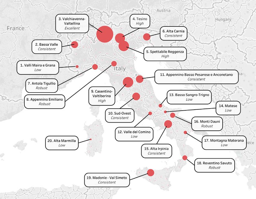
62 Arezki et al. 2009.INNER AREAS AND UNESCO WORLD HERITAGE: WHAT POSSIBLE CONVERGENCES? 97 to positive perceptions63, engagement64 and sense of belonging65 of residents towards the “own” WHS. Nevertheless, some negative impacts can occur, by generating problems of overcapacity in mature destinations66, conflicts between cultural heritage endowment and local policies67 and environmental concerns68. Such evidence suggests that surrounding areas could benefit from the shadows- effect of WHS destinations and in case of Italy, where about the half of the whole provinces are endowed by UNESCO and another half is characterized by problems of marginalization and peripherality, a possible convergence process could surely encourage positive effects for those “learning regions”69. 5. Overlaying heritage endowment and Pilot Project Areas: the potential tourism gravitational basins for Italian Inner Areas After having rearranged the current framework of Inner Areas in Italy and the main principles to manage a World Heritage Site, with particular emphasis on those WHSs located in peripheral destinations and “hosted” by the respective local communities, this work is proposing a geographical approach in order to understand what are the possibilities of Inner Areas to leverage on neighboring WHS destinations and what are the most prone to intercept cultural heritage flows. As place markers of this analysis, the 20 Italian pilot project areas individuated by the SNAI70 were taken into account. This has lead to building a map of potential tourism gravitational basins for the aforementioned areas and this could be helpful for areas’ managers for understanding if preconditions exist to modeling the areas’ strategies relying on the cultural heritage of surrounding WHS areas. For introducing this kind of analysis, a graphical representation of pilot project areas (represented by municipalities) and WHS endowment (represented by the province of belonging) was regarded as necessary. In figure 1 these two dimensions have been overlapped and the first evidence stands out. It appears quite clear that we are in presence of pilot areas who are almost completely merged with WHS destinations (Valli Maira and Grana, Tesino, Spettabile Reggenza, Alta Carnia, Antola Tigullio, Sud-Ovest, Montagna Materana); in other cases, the neighboring proximity is approximate (Bassa 63 Rasoolimanesh et al. 2017. 64 Vollero et al. 2016. 65 Jaafar et al. 2015. 66 Kirkpatrick 2001; Cuccia et al. 2015; Park, Almeida Santos 2017. 67 Xu et al. 2017; Zhang et al. 2015. 68 Hawkins et al. 2009. 69 Hauser et al. 2007. 70 Lucatelli 2016.
98          DANTE DI MATTEO, GIACOMO CAVUTA

Valle, Valchiavenna-Valtellina, Appennino Emiliano, Casentino-Valtiberina,
Appennino Basso Pesarese and Anconetano, Alta Iprinia, Monti Dauni,
Madonie-Val Simeto); while, in some cases, the spatial linkage between Pilot
Areas and WHS provinces is only marginal or even absent (Valle del Comino,
Basso Sangro-Trigno, Matese, Reventino Savuto, Alta Marmilla). From a
general perspective, the first glance on the figure 1 returns a framework in
which northern Inner Areas seem to be the most concerned towards WHS
endowments, the central areas may be fairly involved, while the most southern
areas seem to be far from a possible convergence with WHS provinces.
   In order to understand to what extent pilot areas could benefit from
neighboring WHS provinces in terms of tourism flows, for every pilot project
area each neighboring province with WHS endowments was detected, and for
each WHS province the average number of nights spent involving the 12-year
period of 2005-2016 was computed. In a further moment, the flows of the
province in which pilot areas are located and the flows of the k-neighboring
provinces were aggregated. In this way, it was possible to point out a gravitational
basin of tourism flows for each pilot project area. Depending on the width of
the potential tourism gravitational basins, the 20 pilot areas were classified
through a level of convergence (low, robust, consistent, high, excellent), for
understanding which are the areas who can hypothesize an integrated approach
with local governments of WHS provinces, and who cannot. The results are
summarized in the following table.

N° Pilot project    Province(s)    In-province Neighboring Neighboring Gravitational Convergence
   area                            tourism     WHS         WHS           area’s global level
                                   flows       province(s) tourism       flows (nights
                                   (nights                 flows (nights spent per
                                   spent per               spent per     year; av. value
                                   year; av.               year; av.     2005-2016) –
                                   value 2005-             value 2005- in millions
                                   2016) – in              2016) – in
                                   millions                millions
     Valli Maira
1                   Cuneo               1.49   No               0          1.49     low
     and Grana
                                               Torino,
2    Bassa Valle    Aosta               3.15   Biella,        6.16         9.31     consistent
                                               Vercelli
                                               Bolzano,
     Valchiavenna-                             Trento,
3                  Sondrio              2,44                  54.67        57.11    excellent
     Valtellina                                Brescia,
                                               Como
4    Tesino         Trento             15.31   Belluno        4.36         19.67    high
     Spettabile                                Trento,
5                   Vicenza             1.87                  19.67        21.54    high
     Reggenza                                  Belluno
                                               Pordenone,
6    Alta Carnia    Udine               5.33                  4.85         10.18    consistent
                                               Belluno
     Antola                                    La Spezia,
7                   Genova              3.48                  2.42         5.90     robust
     Tigullio                                  Alessandria
INNER AREAS AND UNESCO WORLD HERITAGE: WHAT POSSIBLE CONVERGENCES? 99
Appennino Reggio dell’ Lucca,
8 0.78 4.95 5.73 robust
Emiliano Emilia Modena
Firenze,
Forlì-
Casentino-
9 Arezzo 1.13 Cesena, 20.28 21.41 high
Valtiberina
Pesaro-
Urbino
Perugia,
10 Sud-Ovest Terni 0.75 Siena, 10.74 11.49 consistent
Viterbo
Appenino
Pesaro-
Basso
11 Urbino and 6.02 Perugia 5.13 11.15 consistent
Pesarese e
Ancona
Anconetano
Valle del
12 Frosinone 1.13 L’Aquila 1.25 2.38 low
Comino
Basso Sangro-
13 Chieti 1.13 L’Aquila 1.25 2.38 low
Trigno
14 Matese Campobasso 0.47 Caserta 0.86 1.33 low
Salerno,
15 Alta Irpinia Avellino 0.20 Potenza, 11.70 11.90 consistent
Foggia
16 Monti Dauni Foggia 4.34 Potenza 0.60 4.94 robust
Montagna
17 Matera 1.37 Potenza 0.60 1.97 low
Materana
Reventino
18 Catanzaro 1.42 Cosenza 3.02 4.44 robust
Savuto
Enna,
Madonie- Palermo and
19 4.85 Messina, 5.07 9.92 consistent
Val Simeto Catania
Agrigento
Alta
20 Oristano 0.44 No 0 0.44 low
Marmilla
Tab. 2. Tourism gravitational basins of Pilot Project Areas (Source: own elaboration on SNAI
plan documents and ISTAT data, 2005-2016)
From table 2, what was previously assumed by a spatial observation is
corroborated by numerical support. The majority of the pilot areas with large
potential gravitational basins are located in the central-north of the Peninsula;
in particular, the area of Valchiavenna-Valtellina in Lombardy region has a
potential basin of about 57 million tourist nights spent per year, followed by
Spettabile Reggenza in Veneto region with 21.5 millions of potential nights
spent, the area of Casentino-Valtiberina in Tuscany region with a potential
gravitational basin of 21.4 million tourists and the Tesino pilot area with 19.6
million of nights spent.
Wide basins of potential nights spent are also found in Bassa Valle (9.3
million), Alta Carnia (10.2 million), Sud-Ovest (11.49 million), Appennino
Basso Pesarese and Anconetano (11.15 million) and, for what concerns southern
regions, good values are found in the area of Alta Irpinia (11.90 million) and in
the Sicilian pilot areas of Madonie-Val Simeto (9.92 million).100 DANTE DI MATTEO, GIACOMO CAVUTA
Lower, but still robust, values are found in cases of Antola Tigullio,
Appennino Emiliano, Monti Dauni and Reventino Savuto, with potential
tourism gravitational basins ranging from 4.40 up to 5.90 million of nights
spent per year. Few possibilities to intercept WHS flows are found in pilot
project areas of Valli Maira and Grana, Valle del Comino, Basso Sangro-
Trigno, Matese, Montagna Materana and Alta Marmilla, where the potential
gravitational basins are well below 3 million of nights spent per year.
Another relevant aspect which comes up from the table 2 is that there are
some pilot areas in which the “hosting” province provides low values and the
neighboring WHS provinces provide very high values of potential nights spent
(such as in Valchiavenna-Valtellina, Spettabile Reggenza, Casentino-Valtiberina,
Sud-Ovest and Alta Irpinia), while there are other pilot areas where the “hosting”
province accounts for good or even higher values if compared to the neighboring
WHS ones (like in Tesino, Alta Carnia, Antola Tigullio, Appennino Basso
Pesarese and Anconetano, Monti Dauni and Madonie-Val Simeto). A graphic
representation of the tourism potential gravitational basins for each pilot project
area and the related convergence level is provided in figure 2.
6. Conclusions and limitations
Once the potential tourism gravitational basins for those areas designed as
a pilot project by the National Strategy for Inner Areas have been identified,
some fundamental questions are going to come out: what are the mechanisms
which should be activated to encourage this convergence? Are Inner Areas
able to handle eventual tourism flows coming from the gravitational basin
of provinces involved in UNESCO protection programs? What could be the
motivating factors able to engage a heritage tourist towards an inner and/or
peripheral area? Are there common features for launching cooperation between
an inner area and a World Heritage Site? Well, the answers to these questions
are presented as difficult, but what is particularly true is that we need more time
for understanding what the real advantages of the national designation of Inner
Areas are.
For instance, one of the first goals of those areas who are planning to
develop major or minor tourist strategies should be the recognition of the
accommodation capacity of the area concerned. This is missing in a lot of areas
for which the early general plan has already been approved. For understanding
what the potential tourism flows towards each area are, a careful refocusing
of the tourism facilities should be carried out upon the moment of writing a
strategic tourism plan for the area concerned. It is the full awareness about the
characteristics of the “own” area the key for understanding what is feasible and
what is not. For example, basing on the descriptive statistics provided in thisINNER AREAS AND UNESCO WORLD HERITAGE: WHAT POSSIBLE CONVERGENCES? 101 paper, future works could be aimed to understand what the maximum carrying capacities – per year – of all the municipalities forming the Inner Areas are, in regard to the potential basins deriving from the neighboring provinces in which UNESCO sites generate plenty of visitors over the year. In a country like Italy where the number and the density of World Heritage Sites denote maximum levels if compared to all other countries worldwide, it would be unreasonable to not take into account the areas in which the WHSs are located in as a possible source of visitors for those “Learning Tourism Destinations”71 branded by peripherality, marginalization and depopulation processes. Since the plan documents of a lot of Pilot Areas mention the cultural heritage72 as a crucial step for developing strategies of a “slow tourism”73, it cannot be discussed if not by considering the neighboring influence of already mature destination from the heritage perspective, such as those with WHS endowments, for the reasons regarding the tourism destination life cycle discussed above. Another relevant issue about a likely merging between Inner Areas and World Heritage Destinations concerns the primary role of local governments: in order to think about partnerships, cooperation programs, joint measures and all it was discussed by UNESCO committees in regards to the role of local communities in tourism planning and development, it is needed an inter- governmental structure which could guarantee benefits for both, by meaning decongestion for mature destinations and tourism (re)population for peripheral destinations. This kind of analysis exhibits the above-mentioned limitations and it cannot be, of course, fully satisfactory and exhaustive for understanding what the trajectories to be undertaken for rebalancing cultural heritage flows in Italian peripheral destinations are, but it opens the door to a wider reflection about this matter. References / Riferimenti bibliografici Albert M.-T. (2012), Perspectives of World Heritage: towards future-oriented strategies with the five ‘Cs’, in Community Development through World Heritage (World Heritage papers 31), edited by M.-T. Albert, M. Richon, M.J. Viñals, A. Witcomb, Paris: UNESCO World Heritage Centre, pp. 32- 38. 71 Schianetz et al. 2007. 72 Regione Abruzzo SNAI 2016; Regione Sardegna SNAI 2016. 73 Regione Molise SNAI 2016.
102      DANTE DI MATTEO, GIACOMO CAVUTA

Alberts H.C., Hazen E.D. (2010), Maintaining authenticity and integrity at
   cultural World Heritage Sites, «The Geographical Review», 100, n. 1, pp.
   56-73.
Andreoli A., Coccu O., Silvestri F. (2017), Nota alla Strategia delle Aree
   Interne: il turismo come opportunità di sviluppo per le aree interne del paese,
   Technical Committee for Inner Areas, ,
   26.03.2018.
Arezki R., Cherif R., Piotrowski J. (2009), Tourism Specialization and Economic
   Development: Evidence from the UNESCO World Heritage List, «IMF
   Working Paper», n. 176, pp. 1-24.
Barca F., Casavola P., Lucatelli, S., edited by (2014), A strategy for inner areas
   in Italy: definition, objectives, tools and governance, Materiali Uval Series,
   n. 31.
Baum T., Hagen L. (1999), Responses to Seasonality: The Experiences of
   Peripheral Destinations, «International Journal of Tourism Research», n. 1,
   pp. 299-312.
Besio M. (2003), Conservation Planning: The European Case of Rural
   Landscapes, in Cultural Landscapes: The Challenges of Conservation
   (World Heritage papers 7), edited by F. Bandarin, Paris: UNESCO World
   Heritage Centre, pp. 60-67.
Borowiecki K.J., Castiglione C. (2012), Cultural Participation and Tourism
   Flows. An Empirical Investigation of Italian Provinces, «Discussion Papers
   on Business and Economics», n. 21, pp. 1-14.
Brown F., Hall C.M., edited by (2000), Tourism in Peripheral Areas, Great
   Britain: Cambrian Printers.
Buhalis D. (1999), Tourism on the Greek Islands: Issues of Peripherality,
   Competitiveness and Development, «International Journal of Tourism
   Research», n. 1, pp. 341-358.
Butler R.W., Hall C.M., Jenkins J., edited by (1998), Tourism and Recreation
   in Rural Areas, Chichester: John Wiley.
Butler R.W. (1980), The concept of a tourist area cycle of evolution: Implications
   for management of resources, «Canadian Geographer», 24, n. 1, pp. 5-12.
Capece Galeota T. (2015), A strategy for Italian ‘Inner Areas’. Fostering
   growth through Inner Areas development, 10th OECD Rural Development
   Conference (Memphis, May 19-21).
Caust J., Vecco M. (2017), Is UNESCO World Heritage recognition a blessing
   or burden? Evidence from developing Asian countries, «Journal of Cultural
   Heritage», n. 27, pp. 1-9.
Cavuta G., Di Matteo D. (2014), Italian Cultural Heritage: reflections and
   perspectives of the UNESCO sites within the National Tourism System, in
   Museums; Cultural identity; Sustainable development, Rome: Valmar, pp.
   349-359.
Puoi anche leggere