2019 IL CAPITALE CULTURALE - Studies on the Value of Cultural Heritage - UniMc
←
→
Trascrizione del contenuto della pagina
Se il tuo browser non visualizza correttamente la pagina, ti preghiamo di leggere il contenuto della pagina quaggiù
19
IL CAPITALE CULTURALE
                        2019
Studies on the Value of Cultural Heritage
 eum          Rivista fondata da Massimo Montella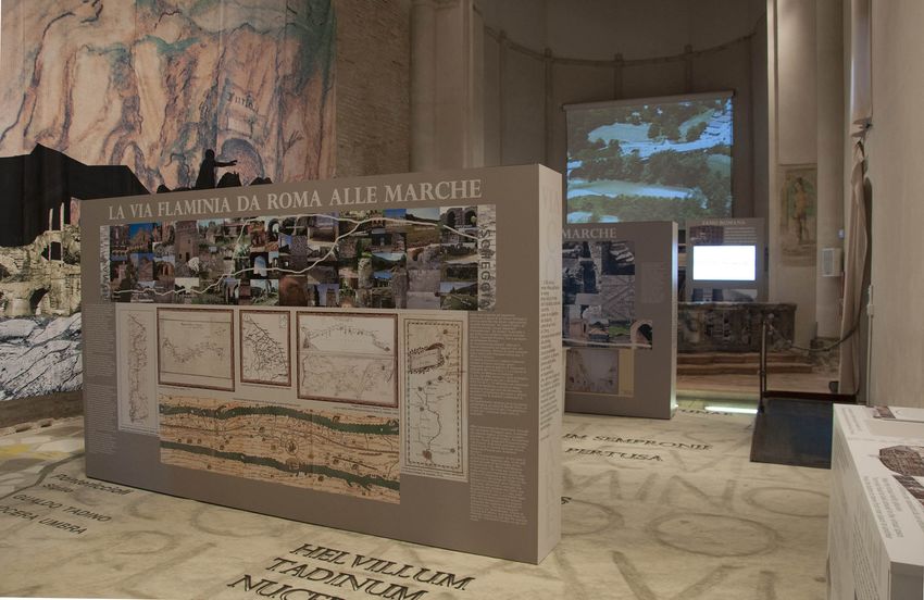
Il capitale culturale                                Gaetano Maria Golinelli, Xavier Greffe, Alberto
Studies on the Value of Cultural Heritage            Grohmann, Susan Hazan, Joel Heuillon,
n. 19, 2019                                          Emanuele Invernizzi, Lutz Klinkhammer,
                                                     Federico Marazzi, Fabio Mariano, Aldo M.
ISSN 2039-2362 (online)                              Morace, Raffaella Morselli, Olena Motuzenko,
                                                     Giuliano Pinto, Marco Pizzo, Edouard
Direttore / Editor                                   Pommier †, Carlo Pongetti, Adriano Prosperi,
Massimo Montella †                                   Angelo R. Pupino, Bernardino Quattrociocchi,
                                                     Mauro Renna, Orietta Rossi Pinelli, Roberto
Co-Direttori / Co-Editors                            Sani, Girolamo Sciullo, Mislav Simunic,
Tommy D. Andersson, Elio Borgonovi,                  Simonetta Stopponi, Michele Tamma, Frank
Rosanna Cioffi, Stefano Della Torre, Michela         Vermeulen, Stefano Vitali
di Macco, Daniele Manacorda, Serge Noiret,
Tonino Pencarelli, Angelo R. Pupino, Girolamo        Web
Sciullo                                              http://riviste.unimc.it/index.php/cap-cult
                                                     e-mail
Coordinatore editoriale / Editorial Coordinator      icc@unimc.it
Giuseppe Capriotti
                                                     Editore / Publisher
Coordinatore tecnico / Managing Coordinator          eum edizioni università di macerata, Centro
Pierluigi Feliciati                                  direzionale, via Carducci 63/a – 62100
                                                     Macerata
Comitato editoriale / Editorial Office               tel (39) 733 258 6081
Giuseppe Capriotti, Mara Cerquetti, Francesca        fax (39) 733 258 6086
Coltrinari, Patrizia Dragoni, Pierluigi Feliciati,   http://eum.unimc.it
Valeria Merola, Enrico Nicosia, Francesco            info.ceum@unimc.it
Pirani, Mauro Saracco, Emanuela Stortoni,
Federico Valacchi                                    Layout editor
                                                     Roberta Salvucci
Comitato scientifico - Sezione di beni
culturali / Scientific Committee - Division of       Progetto grafico / Graphics
Cultural Heritage                                    +crocevia / studio grafico
Gi use ppe Ca pr io tti, M a r a C e r q u e tti,
Francesca Coltrinari, Patrizia Dragoni,              Rivista accreditata AIDEA
Pierluigi Feliciati, Maria Teresa Gigliozzi,         Rivista riconosciuta CUNSTA
Susanne Adina Meyer, Massimo Montella †,             Rivista riconosciuta SISMED
Umberto Moscatelli, Sabina Pavone, Francesco         Rivista indicizzata WOS
Pirani, Mauro Saracco, Emanuela Stortoni,            Rivista indicizzata SCOPUS
Federico Valacchi, Carmen Vitale                     Inclusa in ERIH-PLUS

Comitato scientifico / Scientific Committee
Michela Addis, Tommy D. Andersson, Alberto
Mario Banti, Carla Barbati, Sergio Barile,
Nadia Barrella, Marisa Borraccini, Rossella
Caffo, Ileana Chirassi Colombo, Rosanna
Cioffi, Caterina Cirelli, Alan Clarke, Claudine
Cohen, Lucia Corrain, Giuseppe Cruciani,
Girolamo Cusimano, Fiorella Dallari, Stefano
Della Torre, Maria del Mar Gonzalez Chacon,
Maurizio De Vita, Michela di Macco, Fabio
Donato, Rolando Dondarini, Andrea Emiliani †,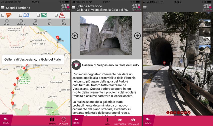
The management of cultural
heritage and landscape in inner
areas

edited by Mara Cerquetti, Leonardo J.
Sánchez-Mesa Martínez, Carmen Vitale
Guardo le canoe che fendono l’acqua, le barche
                                          che sfiorano il campanile, i bagnanti che si
                                          stendono a prendere il sole. Li osservo e mi sforzo
                                          di comprendere. Nessuno può capire cosa c’è sotto
                                          le cose. Non c’è tempo per fermarsi a dolersi di
                                          quello che è stato quando non c’eravamo. Andare
                                          avanti, come diceva Ma’, è l’unica direzione
                                          concessa. Altrimenti Dio ci avrebbe messo gli
                                          occhi di lato. Come i pesci1.

                                          Quando cammino nei prati attorno al Santuario,
                                          quasi sempre solo, ripenso a nonno Venanzio che,
                                          da giovane biscino, pascolava il gregge negli stessi
                                          terreni. Mi affascina il fatto che in questo luogo
                                          la cui cifra, agli occhi di chi guarda adesso la mia
                                          scelta di vita, è la solitudine, nei secoli addietro
                                          abitassero oltre duecento persone. Ancora negli
                                          anni Cinquanta, ricorda mio nonno, erano quasi
                                          un centinaio gli abitanti di Casette di Macereto
                                          tra contadini, mezzadri, mogli, pastori e un
                                          nugolo di bambini che costringeva il maestro
                                          a salire ogni giorno da Visso per fare lezione a
                                          domicilio.
                                          Era una comunità compatta, coordinata come
                                          lo può essere quella delle società operose degli
                                          insetti: api, formiche, tremiti, ma cosa più
                                          sorprendente che mai, una comunità niente
                                          affatto statica o chiusa2.

1   Balzano M. (2018), Resto qui, Torino: Einaudi, p. 175.
2   Scolastici M. (2018), Una yurta sull’Appennino, Torino: Einaudi, p. 50.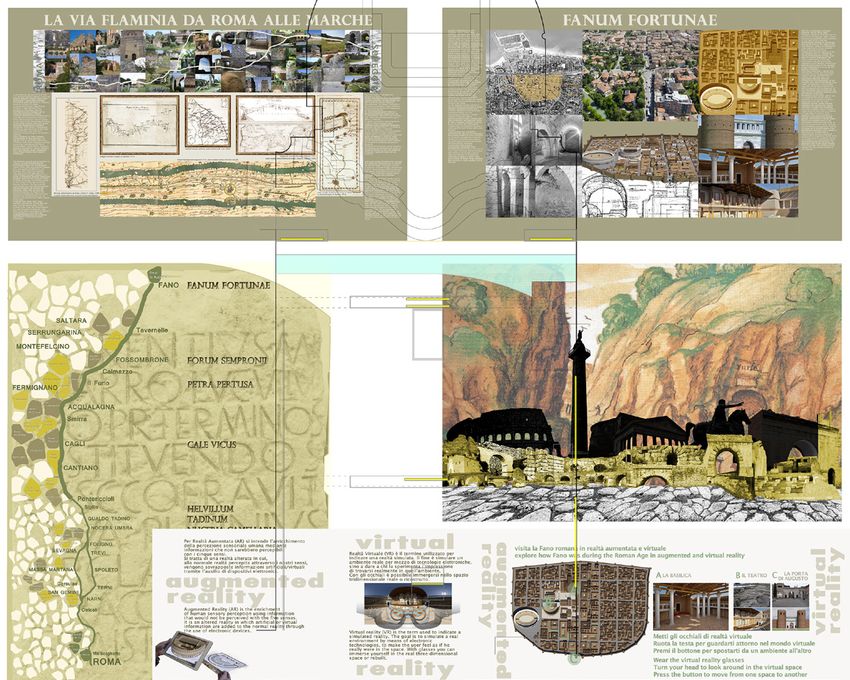
Clini P., Frontoni E., Quattrini R., Pierdicca R., Puggioni M., Archaeological landscape and heritage. Innovative knowledge-
based dissemination and development strategies in the Distretto Culturale Evoluto Flaminia NextOne
«Il capitale culturale», n. 19, 2019, pp. 211-235
ISSN 2039-2362 (online); DOI: 10.13138/2039-2362/1962

Archaeological landscape and
heritage. Innovative knowledge-
based dissemination and
development strategies in the
Distretto Culturale Evoluto
Flaminia NextOne*
                                                             Paolo Clini∗∗, Emanuele Frontoni∗∗∗,
                                                             Ramona Quattrini∗∗∗∗, Roberto
                                                             Pierdicca∗∗∗∗∗, Mariapaola
                                                             Puggioni∗∗∗∗∗∗

    * Although the present paper was carried out together, the §§ 1 e 3 are by Paolo Clini; § 2 is
by Roberto Pierdicca and Ramona Quattrini; § 3.1 is by Roberto Pierdicca and Emanuele Fronto-
ni; § 3.2 is by Ramona Quattrini; § 4 is by Roberto Pierdicca and Mariapaola Puggioni; § 5 is by
Emanuele Frontoni.
    ** Paolo Clini, Full professor of Drawing and Survey of Architecture, Università Politecni-
ca delle Marche, DICEA, Facoltà di Ingegneria, Via Brecce Bianche, s.n., 60131 Ancona, e-mail:
p.clini@univpm.it, https://orcid.org/0000-0002-3253-0634.
    *** Emanuele Frontoni, Associated professor of Computer Science and Computer Vision,
Università Politecnica delle Marche, DII, Facoltà di Ingegneria, Via Brecce Bianche, s.n., 60131
Ancona, e-mail: e.frontoni@univpm.it, https://orcid.org/0000-0002-8893-9244.
    **** Ramona Quattrini, Researcher, Università Politecnica delle Marche, DICEA, Facoltà di
Ingegneria, Via Brecce Bianche, s.n., 60131 Ancona, e-mail: r.quattrini@univpm.it, https://orcid.
org/0000-0001-5637-6582.
    ***** Roberto Pierdicca, Post-Doc, Università Politecnica delle Marche, DICEA, Facoltà di
Ingegneria, Via Brecce Bianche, s.n., 60131 Ancona, r.pierdicca@pm.univpm.it, https://orcid.or-
g/0000-0002-9160-834X.
    ****** Mariapaola Puggioni, PhD candidate, DII, Facoltà di Ingegneria, Via Brecce Bianche,
s.n., 60131 Ancona, e-mail: m.puggioni@pm.univpm.it.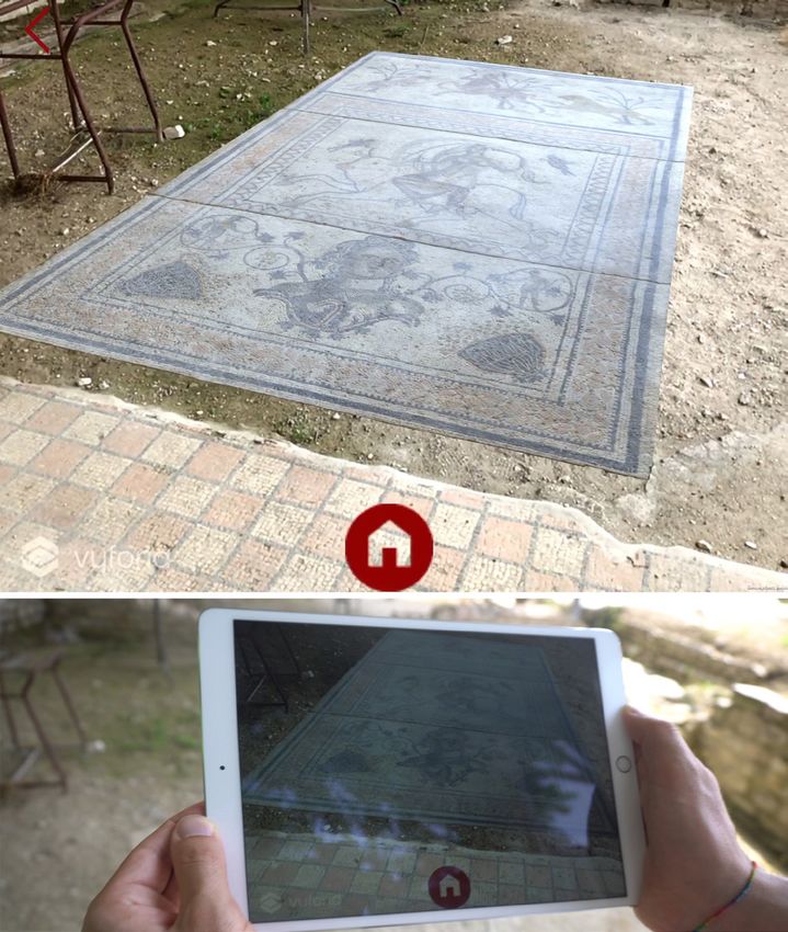
212        PAOLO CLINI, EMANUELE FRONTONI, RAMONA QUATTRINI, ROBERTO PIERDICCA, MARIAPAOLA PUGGIONI

      Abstract

    The adoption of dissemination strategies based on Information and Communication
Technologies (ICTs) has generated a paradigm shift, empowering users to identify, customize
and exploit tourism services. The paper outlines an innovative way to disseminate the
archaeological landscape, based on the Flaminia NextOne Distretto Culturale Evoluto
(DCE) research project. The contribution summarizes the main achievements of the project
in the light of technical improvements in AR applications and mobile cloud management,
and also describes the collaborative approach of a public-private partnership. Data analytics
from the web platform are also provided, in order to understand the potential and the
drawbacks of this methodology. The discussion of the method, the pilot cases and their
scalability derive from the main objective of the project which is to promote cultural heritage
throughout the territory and to study the socio-economic implications of digital mediation,
as discussed in the 2016 L&A En Route seminar.
    L’adozione di strategie di comunicazione basate su tecnologie dell’informazione e
della comunicazione (TIC) ha generato un cambio di paradigma, consentendo agli utenti
di identificare, personalizzare e sfruttare i servizi turistici. L’articolo delinea un modo
innovativo per veicolare il paesaggio archeologico, basato sul progetto di ricerca Flaminia
NextOne Distretto Culturale Evoluto (DCE). Il contributo riassume i principali risultati del
progetto alla luce dei miglioramenti tecnici ottenuti nelle applicazioni AR e nella gestione di
un cloud dati, nonché nell’approccio collaborativo del partenariato pubblico-privato. Viene
fornita anche un’analisi dei dati della piattaforma web, al fine di comprendere le potenzialità
e gli svantaggi della metodologia. La discussione del metodo, i casi pilota e la loro scalabilità
derivano dal valore intrinseco del progetto per promuovere il patrimonio culturale diffuso
sul territorio e studiare le implicazioni socio-economiche della mediazione digitale, come
discusso nel seminario L&A En route del 2016.

      1. Introduction

    The adoption of dissemination strategies based on Information and
Communication Technologies (ICTs) has generated, in the last decade, a new
paradigm shift, empowering users to identify, customize and exploit tourism
services; the main reason lies in the development of novel tools and infrastructures
for managing and distributing services on a worldwide scale. Increasingly,
ICTs play a critical role in the competitiveness and value awareness of cultural
destinations. Following this trend, one of the research domains that benefits the
most from this new policy is the so-called “digital heritage”, which has begun
to transform the process of re-creating and understanding the past. This new
field integrates the traditional expertise of heritage management, museology,
history and archaeology with the powerful new tools of digital information
technologies, with great potential for addressing the new challenges associated
with the sustainability of the heritage sector. ICT is able to transform heritage
from the domain of specialists to that of a wider public, as well as it is a means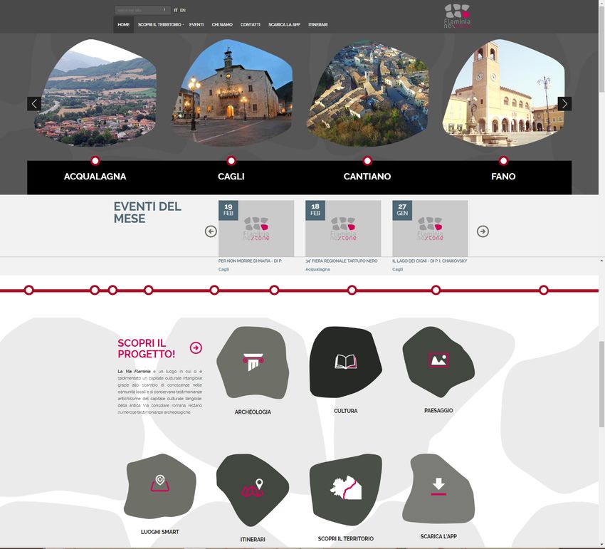
ARCHAEOLOGICAL LANDSCAPE AND HERITAGE   213

for boosting the economic development of local communities and regions,
by strengthening cultural identity and cross-cultural communication. At the
same time, these technologies have produced a wide range of applications for
collecting and processing historical data, for documenting and monitoring
the conservation of objects and monuments, and for creating interactive
information networks that can link professionals and scholars with students,
museum-goers, and anyone interested in cultural heritage.
   In line with this trend, this paper attempts to outline an innovative way to
disseminate and enhance the archaeological landscape, based on the Flaminia
NextOne Distretto Culturale Evoluto (DCE) research project (fig. 1). The
project aims to activate and develop new strategies for the representation,
organization, dissemination and promotion of local cultural heritage, based on
paradigms of technological intelligence, which represent challenges for Smart
Cities and the smart environment indicated by the European Union. In particular,
there is the need for integrated management of the widespread cultural heritage
which represents the identity of a territory: these forms of management have
been exploited and validated by the public-private partnership involved in the
project, thereby enabling the endogenous development of local communities.

   2. State of the art and related works

   The H2020 European funding program, despite the initial disorientation
of both public and private operators due to the substantial replacement of the
cultural heritage field with a cultural and creative approach, is now generating
new forms of collaboration aimed at enhancing and creating sustainable
processes based on technological innovation and ICT applications. In fact,
these processes are easily reproducible and scalable because they are based on
standardized knowledge and involve a strong cost competition in the short
term1. These considerations constitute a key point in the project presented in
this paper, as well as in their measurable outputs, and therefore contribute to
highlighting cultural heritage not only as a productive asset but also as a process
owned and managed by the citizens.
   From its preliminary stages, the DCE NextOne project also took into
consideration the vision of the Faro Convention, which regards heritage not
just as one aspect of tourism but as a fundamental factor for every day, ordinary
“real” life, at both local and universal level. It sees heritage as a process and,
what is more, as a continuing process, which creates, constructs, uses and
modifies the heritage itself; in a sense, heritage is redefined by Faro as a verb,

   1   Montella 2015.
214            PAOLO CLINI, EMANUELE FRONTONI, RAMONA QUATTRINI, ROBERTO PIERDICCA, MARIAPAOLA PUGGIONI

rather than a noun. This emphasis on process rather than product highlights the
relevance of heritage for sustainability2.
   Starting from previous considerations and the good results obtained by two
editions of DCE, the Marche region launched other actions in order to enhance
the capability of the district and to develop integrated territorial policies. The
Marche regional framework actions are in line with the National Strategy for
Inner Areas, which aims to oppose the process of marginalization that, in the
last fifty years, has affected the Apennine mountain areas. This process is due
primarily to the progressive increase in the aging phenomena and the low birth
rate, lack of infrastructures (roads, railways and broadband connections), and
unemployment. These factors are accompanied by a gradual decrease in the
quantity and the quality of local public, private and community services3. Such
challenges can be dealt with by setting up some interconnected projects focused
on a few selected priority fields of intervention and linked with ordinary policy
(supply of services). Strategic projects concentrate on a limited number of fields:
land management and forests; local food products; renewable energy; natural
and cultural heritage; traditional handicrafts and SMEs (Saperi Locali). Our
approach deals with both the last two fields, trying to harmonize the exploitation
of natural and cultural heritage with new ICT skills that are also linked with
forms of creativity and local know-how.
   The cultural heritage sector is particularly affected by a digital mediation
in Cultural Heritage (CH) Digitization. Online or on-site accessibility of
cultural contents (thanks to mobile and AR applications) shake up traditional
models, transform value chains and call for new approaches to our cultural
and artistic heritage. The process is robust enough and well demonstrated by
the most recent literature. In fact, whilst a few decades ago CH-related tourism
was entrusted to direct experience in the field, nowadays it is more oriented
towards the digital approach. The journey starts on the web, where visitors can
find preliminary information about what they are going to visit, supported by
feedback from other users. After arriving at the destination, users can collect
digital information that can be shared by means of mobile tools, and at the same
time can obtain contextual information thanks to geo-localization services.
Finally, after the visit, the experience continues on social networks and/or on
the web4. Recent research trends demonstrate that the mainstream relies on
intelligent tourism recommender systems5. In these examples, systems enable
the users to plan their visit and, at the same time, keep track of user preferences
with two kinds of services:

      2   Fairclough et al. 2014.
      3   Bocci et al. 2016.
      4   Rezaei et al. 2016.
      5   Borràs et al. 2014; Emmanouilidis et al. 2013; Gavalas et al. 2014.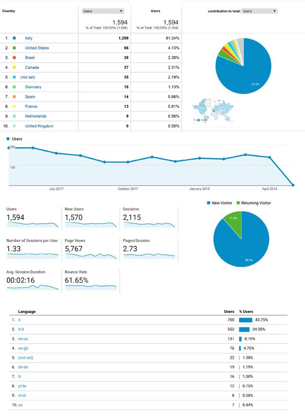
ARCHAEOLOGICAL LANDSCAPE AND HERITAGE   215

   –– applications that implement a search for information about the tourist
       from Internet sources;
   –– applications that have their databases with information about attractions
       and provide this information to the tourist.
   Even if the web has changed how tourists search for their cultural destination,
there is no doubt that the appearance of mobile devices in our daily lives has
changed the way in which the surroundings are experienced. From a customer
perspective, the literature on mobile technology examines the adoption of
technology, and studies the impact of behavior and technology on the overall
experience of the trip6. The prevalence of smartphones has had huge implications
for planning journeys during, before and after visiting a destination. It has been
demonstrated that the planning process has become easier as a result of having
ubiquitous access to the Internet using mobile devices7. Among countless
services and apps that can be useful for the cultural sector, Augmented Reality is
promising, since it enables the location-based information of real-world objects
to be explored, thanks to the contextual visualization on the screen, with the
same viewpoint as the user. With an AR-enabled mobile device, it is possible to
easily access additional information about a Point of Interest (POI)8. Location-
based services can change the way people experience their surroundings, and,
unlike the use of simple maps, AR allows a continuum with the surroundings
without the need to pay attention to the screen; indeed, the possibility of using
AR to discover new POIs represents a state-of-the-art approach9.
   For the sake of completeness, after considering the most relevant works about
web- and app-based applications, it is fair to say that the future of the tourism
sector lies in the development of services that are able to provide information for
the users and, at the same time, to collect their data. An example that is worth
mentioning is the European project known as CyberParks COAST action.
   By providing users with digital services, managers and decision-makers
can collect so-called User Generated Data (UGD)10. Currently, the digital
footprints left by individuals in their daily activities can be used as data to
draw up statistics and to extract metrics about our surroundings, directly from
the users11. The advantage of collecting digital footprints changes according to
the different domains; however, the tourism sector can benefit the most from
such an approach since the collection and the analysis of digital footprints can
be useful in understanding tourist behavior with respect to a destination. In
fact, there is a mutual advantage for both tourists and stakeholders: tourists
are more knowledgeable about the place they are going to visit, whereas

   6 Wang et al. 2013; Wang et al. 2016; Tan et al. 2017.
   7 Yovcheva et al. 2013.
   8 Garau 2014; Aluri 2017; Pierdicca et al. 2016.
   9 Jung et al. 2015.
   10 Simon 2016.
   11 García-Palomares 2015.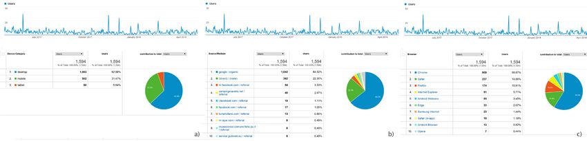
216            PAOLO CLINI, EMANUELE FRONTONI, RAMONA QUATTRINI, ROBERTO PIERDICCA, MARIAPAOLA PUGGIONI

digitally active stakeholders, like insiders and operators, can easily obtain user
feedback to evaluate the performance of their offers. This goes alongside the
possibility to promote the cultural value of a specific, and maybe unknown,
area throughout the world. Data analytics can improve the planning process by
forecasting trends, marketing, measuring economic impact and benchmarking
tourism data12. In this respect, there is clearly a need to set up an integrated
platform which is able to provide services and to monitor tourism performance.
The work presented here attempts to solve this issue; some results13 and pilot
projects14 or outputs15 from the DCE NextOne project have already been
published. The present contribution aims to summarize the main achievements
of the project in the light of technical improvements in AR applications and
mobile cloud management as well as through the collaborative approach of
public-private partnerships.

      3. Method

   The ancient consular route, that connected Rome to the Adriatic Sea, served
as the main street connecting the Roman towns of Fanum Fortunae, Pisaurum
and Ariminum. The area along the Ancient Flaminia is extraordinary, offering
a significantly layered landscape16 (i.e. archaeological remains, historical
monuments and natural scenery, ancient and modern infrastructures). For the
documentation and preservation of this complex and remarkable heritage, it is
mandatory to use cutting edge survey technologies, integrated data management
and innovative communication systems. Although previous research studies
and several scientific surveys have already been carried out, a major drawback
is their fragmentary non-reusable nature. In order to promote economic
culture-based development, in 2013 the Marche Region launched the project
called Distretto Culturale Evoluto (DCE), which is now in its final stage, the
methodology and outcomes of which are worth sharing with the research
community. In fact, this project represents a good example for strengthening
the relationships between the identity of local communities and the territory.
The project stressed the potential of digital cultural heritage for stimulating a
new born cultural industry, fostering economic growth and occupation in this
area of the Marche Region and implementing the guidelines of the European
agenda for culture, by integrating the cultural and creative sectors into regional
and local development strategies. This paper, therefore, demonstrates how it is

      12   Szopiński, Saniewski 2016.
      13   Clini et al. 2015.
      14   Crinelli et al. 2016
      15   Clini et al. 2017.
      16   Luni 1989; Luni 2002; De Sanctis 2010; Luni, Mei 2013.
ARCHAEOLOGICAL LANDSCAPE AND HERITAGE 217
possible to increase this identity and promote cultural tourism in the region,
thanks to the survey, investigation and representation of the Architectural and
Archaeological Heritage (AAH).
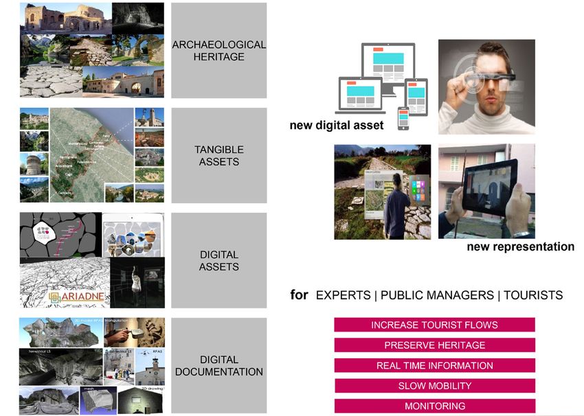
It is well known that sharing information is very important at all times.
Information must be able to flow quickly and accurately and ICT has become
an almost universal feature of the tourism industry. To that end, several
methods and best practices were tested and developed in a real scenario. First
of all, a complex infrastructure was built, using a cloud-based architecture,
for the management of multiple kinds of data with a multi-purpose vision. All
these data (consisting of archaeological surveys, 3D reconstructions, historical
information, 360° spherical images and so on) have been organized to be
available at different scales; in particular, a web-portal allows the visitor to
browse the Points of Interest (POIs), which are geo-localized and enriched with
multimedia contents. While navigating, users can choose their personalized
paths. Moreover, a mobile application (for iOS and Android) is available for use
once they arrive at the destination. In fact, thanks to geo-localization services, an
Augmented Reality (AR) browser allows users to search for the nearest POIs in
a more efficient and interactive way. A further already ongoing, an application
is the development of a vision-based AR application, which enables the user to
see a 3D reconstruction in real scale. For the validation of this methodology,
some pilot projects were performed.
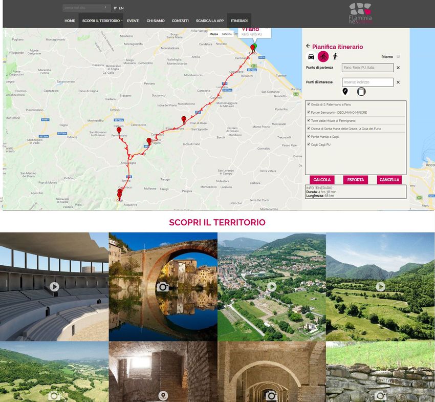
3.1 The cloud repository and the web/mobile app
The Flaminia NextOne17 web portal was developed, following the cloud-
based services paradigm, with the aim of creating a long-term and linked open
data platform, designed for CH-related repositories (fig. 2). As stated by EU
MEMO/11/745:
Through digital libraries people can visit the past in a virtual way to experience Europe’s
cultural wealth and history. Once digitised, cultural material is a valuable resource for
creators and businesses, who can reuse it to develop innovative products and services, for
example for education and tourism or games and animations18.
According to this assumption, the cloud-based architecture allows
interoperability between different platforms (on-site, online, mobile) and
between different users (augmented usability of metadata for both experts/non-
experts). Based on these criteria, the web platform was developed with Simplit
CMS, which allows the portal contents of sites (Internet and intranet) to be
managed and maintained in a simple, fast and secure way. Particular attention
17 , 30.09.2018.
18 , 30.09.2018.218 PAOLO CLINI, EMANUELE FRONTONI, RAMONA QUATTRINI, ROBERTO PIERDICCA, MARIAPAOLA PUGGIONI
was paid to the integration of the information. In fact, while populating the
database, different stakeholders, as well as heterogeneous data, were involved.
For this reason, web-services were developed in order to facilitate the integration
of information from external Data Bases. This portal is programmed using an
open source general-purpose scripting language Hypertext Preprocessor (PHP),
the Google Maps API and JQuery libraries and components (fig. 3). All graphic
solutions are programmed by Cascading Style Sheets (CSS) 2.0 files according
to modern web standards (XHTML and HTML5). This allows the appearance,
the constructive elements of the page (tag), and the content to be considered as
separate elements. W3C recommendations have been followed and all pages
have been submitted for HTML/CSS validation. In order to reach a wider
public, the portal is compatible with all browsers and mobile operating systems.
Particular attention was paid to the possibility to share the contents on the most
important social networks, in order to increase the popularity of the network
itself. Following Web 2.0 philosophy, the contents can be evaluated by users.
Moreover, the back end was designed for web-based management, making it
accessible from any browser using personal credentials. The application uses
an open source database and is multilingual given the importance of contacting
foreign visitors. Although the web portal is mandatory for spreading information
about the Flaminia NextOne project, the mobile solution is also important,
both for retrieving the same information from the Data Base and for exploiting
more functionalities directly on site.
The mobile application is a cross-platform mobile app available on
Android as well as on iOS devices. It provides information such as product
news, company lists, contacts etc., also allowing user participation by sending
comments, ideas, suggestions, etc. The geo-localization service, which retrieves
the information from the Data Base, has the twofold advantage of suggesting a
preferred itinerary to the users and enabling the Location-Based AR service, as
explained below. Within the app, a specific AR engine has been developed. This
tool permits the registration of virtual objects in the camera scene, based on
the user’s location and orientation. To determine these two, the device makes
use of a GPS receiver to retrieve the user’s location in the real world, and a
gyroscope and compass to obtain the user’s orientation. In other words, the
system relies on (geo)localization services to determine the distance between the
user and the Points of Interest (POIs) that are present in the surrounding area.
Archaeological sites might have countless objects which are worth noticing,
and the closer the user is, the higher is the risk of error, caused by the GPS
receiver’s lack of accuracy. Notwithstanding this drawback, several tests have
been performed to achieve a good visualization of both Geolayers with textual
information and 3D model visualization (fig. 4). The iterative improvements of
the digital 3D clone are enabled by the interaction of external expert users who
create/view/edit/update a view of a given AAH 3D object. The view on an AAH
model provides the following advantages over a classical model:ARCHAEOLOGICAL LANDSCAPE AND HERITAGE 219
–– views can represent a subset of the Data in a given time with a given Level
of Detail (LoD); a given user may have permission to view/edit/update/
create a new view without modifying the original data but extending it;
–– views can hide the complexity of the data;
–– views need little space for storage;
–– views can be linked to other views and to other data within the metadata
set.
After this description of the digital services developed for the project, tests
and validation pilot projects will be described in the following section.
3.2 The pilot projects: tangible digitization and knowledge-based
representation for the archaeological landscape
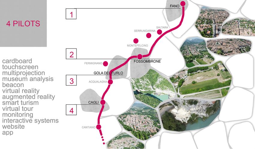
The project allowed four pilot studies to be set up (fig. 5) along the Flaminia
road: the “Virtual Museum of Via Flaminia” in Fano, the mobile app for
augmenting contents at the Forum Sempronii archaeological excavation, the
VR/AR exhibition at the Furlo Gorge and the interactive installation in Cagli
Museum. This paragraph presents the main achievements and novelties for
each pilot project, because they are conceived not as a result but as an incubator
for further progress.
The first pilot project developed is the “Via Flaminia Museum” in Fano19: it is
a completely Digital Museum, conceived as a gateway to the district as a whole,
using innovative media to show high-quality contents (from a multiplicity of
survey and representation systems) through Mixed Reality (AR/VR) and cutting-
edge devices. This Digital Museum metaphorically contains all the evidence
found along the consular road because it brings together the research experience
of the survey and the digital representation of the archaeological heritage. The
preparation of digital documentation dealing with museum attendance in such
a large and complex area required multidisciplinary contamination, ranging
from computer scientists to digital documentation experts collaborating in a
transdisciplinary team with archaeologists and architects (fig. 6).
19 A DCE pilot by the Municipality of Fano (Massimo Seri Major; Stefano Marchegiani; Grazia
Mosciatti; Claudia Cardinali; Ivan Antognozzi Project manager DCE Flaminia NextOne), in
partnership with Fondazione Cassa di Risparmio di Fano, Soprintendenza Archeologia, Belle Arti
e Paesaggio delle Marche and Centro Studi Vitruviani. Scientific consultancy Università Politecnica
delle Marche-DICEA, leaded by Paolo Clini. Exhibitions: Anna Paola Pugnaloni, Adriana Formato.
Multimedia: Romina Nespeca (supervisor), Floriano Capponi, Roberto Catozzo, Adriano Mancini,
Gianni Plescia, Ludovico Ruggeri, Luigi Sagone. Assistants: Renato Angeloni, Roberta Barcaglione,
Claudia Brocchi, Elena Camerini, Anna Marconi, Roberto Pergolesi, Giulia Crinelli, Massimo
Orselli, Laura Bertuccioli, Laura Invernizzi, Gianluca Gagliardini. Partnership with Università degli
Studi di Urbino Carlo Bo: archaeological contents by Valeria Purcaro, Oscar Mei. Equipment:
Esserci s.r.l., Grottini Lab e Si2G.220 PAOLO CLINI, EMANUELE FRONTONI, RAMONA QUATTRINI, ROBERTO PIERDICCA, MARIAPAOLA PUGGIONI
The “Via Flaminia Museum” is divided into three main sections. The first
part of the museum itinerary shows the visitor the original layout of the road
from Rome to the Marche Region: here the main role is played by a carpet
representing paving stones, and by a giant canvas representing the architectural
and monumental highlights of Roman history, such as Ponte Milvio, the
Colosseum and the Arch of Augustus. A second section investigates all the
municipalities along the consular road from Scheggia to Fano. A final specific
section is dedicated to Fano during the Roman age. The representation of such
a vast archaeological heritage and the availability of a large amount of data
from different surveys allow new communicative formats20 to be experimented,
ranging from videos and art galleries to more immersive experiences, i.e. 360
virtual tours, 360 videos, 3D models and point clouds and their exploitation
through AR/VR (fig. 7).
In accordance with the London Charter and the Seville principles, the
content was generated with a focus on intellectual integrity and the reliability
of the historical sources. Another innovative solution adopted consists in the
collection and organization of data on a cloud server system which has the
advantage of providing a great number of models and 3D captures that can
be used for various outputs: the main goal achieved was the extension of data
scalability across various technological installations within the same museums.
In addition, the system allows further installations and the use of the same data
and their semantical organization and interpretation to be used even in other
contexts or with other project partners.
The development of the contents required dedicated data capture campaigns
(photographic and geometric), using cutting-edge and standard technologies
(photogrammetry, laser scanners, 360 cameras, HD photos, RPAS, etc.). Thanks
to a helicopter flight, arranged in collaboration with the Corpo Forestale
Italiano, for this project it was possible to carry out a survey of the whole Via
Flaminia landscape, from Fano to the Scheggia Pass.
A totem touch screen welcomes visitors in the museum entrance and introduces
users to the cloud data system for consulting the DCE digital library and the
portal that connects the whole itinerary. After this area, a panel system integrates
a touch screen that focuses on the appearance of the city of Fossombrone, also
known as Forum Sempronii, in Roman times; this is one of the richest historical
sites as regards the quantity of findings along the Via Flaminia. This section
will be “dynamic” as it will change periodically, so as to also focus on other
DCE partners. Another multimedia workstation along the itinerary allows both
the virtual navigation of the area through geo-referred geographic interfaces
and, at the same time, visualizes the contents from the cloud data. This section
consists of a horizontal touch screen and a vertical screen, with a dedicated
html system, and both the display interfaces retrieve contents. A fourth area
20 Garau, Ilardi 2014.ARCHAEOLOGICAL LANDSCAPE AND HERITAGE 221
is dedicated to evidence from the ancient Fanum Fortunae, displaying roads,
findings and three-dimensional reconstructions. Above all, the most important
feature is the video of the 3D integral reconstruction of the whole city as it
would have appeared, according to studies, in ancient Roman times. This last
exhibition section is closely linked to one of the most popular and interactive
workstations in the Museum: the desk dedicated to AR and VR applications.
The museum provides a tablet to display reconstructed models of the Augustus
Arch, the Roman Theatre, and Vitruvius’ Basilica in Fano. Google Cardboard
allows for immersive navigation in the panoramas of these archeological areas
both as they are now and in their historical reconstructions.
Through the “Museum Visitors Behavior Analysis”21 system, it is possible to
have a precise and innovative understanding of the interaction between visitors,
the environment and cultural proposals by monitoring the number of visitors and
the effectiveness of the interactive systems. Within the museum, two observation
points have been identified that provide user action data and analytical reports.
The Museum Analytics technology monitors visitor activities through advanced
sensor tools for digital vision. Moreover, a team of Data Scientists is currently
working on the information produced by these tools in order to make it useful
for verifying the museum’s performance. Each observation point provides
dashboards with information on three indices: attraction, number of steps and
stops (to define to what extent visitors are interested in the various proposals);
attention, the average stay time that visitors dedicate to the proposals; action,
number of stops and interactions (which provides a measure of interest and
interaction with the proposed installations).
Considering the potential of Augmented Reality (AR) technology22, based
on mobile devices and the effectiveness of its outputs and possible applications
when 3D contents with photorealistic textures are managed, the pilot project
of Forum Sempronii23 was conceived to develop immersive AR on a real
scale. The workflow, from the generation of contents to the processing and
the development of the final application, encountered several difficulties. The
improvement and assessment of dedicated workflows24 is still a matter of
debate, despite the availability of proprietary or open-source platforms for AR/
VR and so on. The Forum Sempronii app25 develops new types of interaction
on a real scale and enhances existing evidence with immersive experiences. In
21 The system was developed in collaboration with the project partner Grottini Lab.
22 Pierdicca et al. 2015.
23 Luni, Mei 2013; Luni, Mei 2014.
24 Clini et al. 2016.
25 The Forum sempronii AR app was developed by DICEA and DII which are departments of
the Università Politecnica delle Marche. Supervision: Aldo Franco Dragoni and Ramona Quattrini.
Supervision of archaeological contents: Oscar Mei. Virtual reconstructions: Laura Invernizzi, Laura
Cocon, Anna Marconi. 3D modelling: Ludovico Ruggeri, Floriano Capponi. APP development:
Elia Alesiani, Luca Quercetti, Angelo Serafini. Layout: Anna Paola Pugnaloni. Other contents:
Romina Nespeca, Gianluca Gagliardini, Luigi Sagone. Technical partners: EVE spin off, EB World.222 PAOLO CLINI, EMANUELE FRONTONI, RAMONA QUATTRINI, ROBERTO PIERDICCA, MARIAPAOLA PUGGIONI
fact, a major achievement of the application presented here is the fact that
it offers users the chance to move around and browse the model from their
position in the area.
The Forum Sempronii AR app has been developed for Android and iOS,
using the Unity development platform and the Vuforia library for the real scale
AR. The app consists of a main scene, a top view picture of the archeological
area, from which the user can access the pages dedicated to the point of interests
(POIs) of the Forum Sempronii, and can then switch to AR mode, activating
the real scale AR. In the main scene, the users can select one of the four POIs,
according to their current position in the archeological area: the “Decumano”,
the “Botteghe”, the “Domus Europa”, and the “Anfiteatro”. Once the user
selects a POI, the app displays a written description as well as a button to
activate the AR. The four POIs are able to perform three distinct types of
function: the “Decumano” is used to show the Level of Reliability (LoR) of
reconstructed parts of town; the “Botteghe” and the “Anfiteatro” use AR to
provide the virtual reconstruction of lost architecture. Finally, the “Domus
Europa” demonstrates the repositioning of artifacts, by superimposing a mosaic
which is currently conserved in a city museum onto the floor of the house which
is decorated in ancient times (fig. 8).
In Cagli, in a traditional and recently renovated museum dedicated to the Via
Flaminia, the DCE NextOne project has introduced an interactive installation26
based on a video projector, the so-called StarkMatrix. It can be used to project
on the wall or the floor, generating interactive surfaces without frames and
screens. In this way an integrated system of projection and interaction is
obtained, which creates highly effective and extraordinary pictures and videos
of the Via Flaminia, revealing simple details like flowers and water. The effects
are generated by the people walking in the area. The effects are customizable
and are developed using high quality 3D technology, which highlights the great
potential and the natural assets of the region.
The last pilot project was dedicated to the natural and cultural heritage in
the Furlo Gorge area. This is a relatively small installation, based on a screen
and an AR/VR access point. The main success of this project was the complete
interoperability of the new installations with previous contents (such as the
cloud contents or the Museum of Fano contents), thereby achieving another
main goal of the project, i.e. the replicability of digital contents and their
potential in the sustainability of CH promotion. In addition, the replication of
similar or the same contents in several places and sites of the DCE realized the
network. In this regard, each pilot project became a gateway to the Flaminia
NextOne District identifying the archaeological influences and the potential of
the area.
26 The system was developed with the DCE NextOne project partner Stark.ARCHAEOLOGICAL LANDSCAPE AND HERITAGE 223
4. Analysis and discussion
One of the main outcomes of the project is a multichannel tourist information
system with a website and mobile app, enriched by some on-site experiences
as described in the pilot project section. All the contents are managed from
a cloud-based service that brings together and shares all the information
and multimedia contents. Furthermore, it is important to underline that the
platform was also designed for collecting different types of user statistics on
tourist behavior and, more in general, for monitoring the performance of the
service, and hence the tourism services provided. In fact, the novelty introduced
by DCE Flaminia NextOne is fundamental for sharing knowledge on various
archaeological sites and micro-museums along the Via Flaminia. However, it
is important to mention that the funding of the project is sufficient for only a
small area of the whole territory encompassed by the Via Flaminia, even if an
extension to the entire cross-regional area would be desirable. The geographical
position of the Via Flaminia in fact cannot take advantage of the flow of tourism
which is generally oriented towards the coast or places located near the main
highways with a consequent negative impact on sites of cultural relevance. For
this reason, one of the missions of the project is to spread awareness of these
outdoor and indoor sites, which are found throughout the Marche Region
from Fano to the Apennines, bordering the Umbria Region. Indeed, the part of
the Via Flaminia involved in this project stretches from the valley of the River
Metauro to near Cantiano. The role of ICT becomes paramount for attracting
visitors even to those areas which cannot be reached using the normal and well-
established tourist routes.
ICT can help to direct this flow of tourism towards less accessible sites
but, in order to understand their popularity, it is necessary to provide local
administration with real data coming from the users27. This is, to date, the only
way to improve the decision-making process so as to intervene with a data-
driven approach.
The data collection period spans over one year – from May 2017 to May
2018 – analyzing data from both the web site and the mobile app, in order to
understand the potential and the drawbacks of the proposed methodology. The
first consideration that arises from the data is that tourists prefer to enhance
their knowledge with the use of desktop applications (web-browsers) rather
than during the visit with the mobile app. This means that the platform is mainly
used either before or after the visit. This preliminary information should make
the platform managers understand that the mobile app needs to be advertised,
especially as an interactive guide along the itinerary of the Via Flaminia, to
involve the tourists more with the use of digital services.
27 Chung et al. 2015.224 PAOLO CLINI, EMANUELE FRONTONI, RAMONA QUATTRINI, ROBERTO PIERDICCA, MARIAPAOLA PUGGIONI
All these data can be matched with those related to the category of the
device which confirms that most browsing on the platform is from desktop
applications; only a small subset of the sample (6%) makes use of the AR
service, mainly using tablets. It is worth noting that 64.32% of the sample uses
the Google Chrome search engine, which is an indicator that the platform is
well indexed and has a high degree of visibility (fig. 9).
Some insight is also available as regards countries and languages. It is
interesting to note the involvement of non-European users (10%), demonstrating
that these kinds of applications allow cultural heritage sites to connect with a
vast range of visitors, even from foreign countries. The Multilanguage function
of the platform is therefore fundamental (fig. 10).
Further analysis of the data shows that during the winter months there is a
slight reduction in the number of accesses, meaning that advertising should be
supplemented in order to attract more visitors in those periods (tab. 1). From
the weekly accesses, it can be inferred that the platform is used more during
the first days of the week. This is presumably because the website is used after
a direct visit to the site, which is more likely to happen during the weekend (as
demonstrated by the on-site use of the mobile application). Hence the users
are more interested in learning about the site if they have already visited the
museums or the POIs.
In the light of this information, the potential of the platform is enormous
for both visitors and policy makers. An analysis of the data indicates that the
former find the platform of interest and useful for increasing the knowledge and
understanding of the area they visited, while the latter have at their disposal a
platform which at the same time allows the visitors to be monitored and tourist
services to be promoted.
Month Visitors % w.r.t. the total
May 2017 183 10.70%
June 2017 183 10.70%
July 2017 157 9.22%
August 2017 146 8.57%
September 2017 114 6.69%
October 2017 114 6.69%
November 2017 139 8.16%
December 2017 117 6.87%
January 2018 133 7.81%
February 2018 129 7.57%
March 2018 150 8.81%
April 2018 137 8.04%
Tot. 1702
Tab.1. Flaminia NextOne web portal visitors, numbers and percentages (Source: Google
Analytics, authors elaboration)ARCHAEOLOGICAL LANDSCAPE AND HERITAGE 225
Given the main aim of the project which was to promote cultural heritage
throughout the territory and to study the socio-economic implications that can
arise from this type of digital-mediated approach, some action should be taken
to further develop the system:
–– the promotion of the platform should be bidirectional, meaning that it
should also be promoted by each municipality;
–– the information should be spread using different channels to attract
schools and/or other sectors of users, especially during the low season
with fewer tourists;
–– UGD should be monitored in order to understand the real behavior of
visitors directly on site.
Another positive outcome of the DCE Flaminia NextOne project was the
Landscape &Archaeology (L&A) seminar, that was held in 2016. The need to
foster – as a tourist attraction and a cultural asset – and to maintain such an
outstanding heritage, motivated local politicians and public administrators to
begin a series of actions in the framework of the Roman past surrounding the
Flaminia region. The remarkable territorial setting (i.e. archaeological remains,
outstanding rural and natural landscapes, ancient and modern infrastructures
and heritage) is well known, but there is a recognizable need to scale up its
reputation in various scenarios. To that end, thanks to the involvement of the
Centre for Vitruvian Studies (CSV), local administrators acknowledged a joint
initiative by our University and Urbino University. The L&A En Route seminar,
with the patronage of Uniscape, was dedicated to discussing smart forms of
cultural tourism and rural-environmental tourism. In order to strengthen
the relationship between the inhabitants and the places where they live, it
also raised important questions concerning the revitalisation of territorial
and historical heritage, and the demand for its sustainable development and
conservation. More in detail, the seminar investigated how it is possible to
increase cultural identity and promote cultural tourism in the region, thanks
to the knowledge, representation and promotion of the architectural and
archaeological heritage and landscape, a broad sense. One main goal for the
“Landscape & Archaeology” seminar was to share and compare positive
experiences in several different areas of the tourist industry, and in the use,
preservation and dissemination of landscape and archaeological heritage. In
particular, the event discussed how to make the preconditions and their results
SMART (specific, measurable, achievable, realistic and time-related). The
seminar provided a forum conducive to sharing best practices (by researchers,
designers, SMEs) deriving from real experiences. In many European countries
local cultural heritage is a powerful driver for developing various economic
activities related to tourism. Management and open access to cultural heritage
are challenges in territorial democracy, enabling local communities to conserve
their resources. There are three main preconditions for the development of
sustainable cultural heritage tourism: a) a good knowledge of cultural heritage;226 PAOLO CLINI, EMANUELE FRONTONI, RAMONA QUATTRINI, ROBERTO PIERDICCA, MARIAPAOLA PUGGIONI
b) a strong awareness by local people for the protection of cultural heritage in
any economic activity; c) the possibility to access innovative and creative ICT
tools to design tourism solutions which have a low impact on the environment
but are relevant for local identity. The key topics, discussed during the itinerant
seminar, were: Smart Landscape, Archaeology and digital documentation
and Smart Industrial Archaeology. Furthermore, a special session attempted
to shed some light on the sustainable promotion of heritage and on Cultural
District initiatives. These subjects are of interest to a wide range of public and
private stakeholders in the Marche Region, many of whom attended this special
session28. Overall, the staging of this event can be defined as a success: in fact,
the seminar was the first initiative organized and managed by the partnership
as a whole.
A further achievement, which arose from the Flaminia NextOne project
conclusions, is the scalability of some actions developed by similar online
networks for the dissemination of cultural heritage, such as the online website
for the archaeological heritage of the Marche Region. This latter project, now
in its final stages, is called Marcheology – Portal of the Marche Archaeological
System and comes within the framework of the Museums and Development of
Territorial Systems program (MuSST). Thanks to this funding, the Directorate-
General for Museums aims to support regional museum networks in the
promotion of territorial networks, in participatory dissemination and in the
creation of integrated cultural itineraries. The project, jointly developed by our
research group and the Polo Museale Marche, concerns the promotion of the
uniqueness of archaeological heritage and aims to strengthen the identity of local
communities thanks to a network between cultural heritage sites. Undoubtedly,
this was made possible, in a short time and with limited funding, thanks to
synergies with previous projects such as DCE NextOne, involving part of the
archaeological heritage of the Marche region. Thanks to the Marcheology29
portal, the Flaminia cloud is now scaled up to a larger territorial scale.
5. Conclusions
At the end of this four-year project, it is possible to state that it has represented
a great opportunity to provide the territory with digital tools, developed to
create a clear and uniform system that can be used by both the local population
and tourists. The proposed system, that is integrated and modular, allows
multiple information to be managed ensuring an interoperable and multi-
channel approach. All the data can be conveniently displayed in different ways:
28 Further details are shown in Clini et al. 2016.
29 , 30.09.2018.ARCHAEOLOGICAL LANDSCAPE AND HERITAGE 227 web portals, fixed installations (indoor), mobile devices (smartphones and tablets), thereby guaranteeing a useful granularity of the system which can be exploited at different levels of detail. The proposed cloud architecture is also tailored to satisfy two major needs. The first objective was to make significant progress in design methodologies and general reference architectures regarding robotic-assisted surveying/processing/ management and communication of cultural heritage. The second consists in providing a way to open up and share the data within the community (experts, art lovers) using a cloud and connected open-source services based on the Web 2.0 observation that users can enrich data. In that direction, one of the main purposes is to allow users to comment, better describe, complete and add multimedia material to these Open Data concerning CH contents; every action performed in a participative manner is considered as user-generated content and described as a second level layer with respect to CH official data which is produced by experts working in the relative public administrations. Another important aspect is that the system developed was also designed in order to monitor and track the so-called User Generated Data (UGD), which represent the future pathway for analyzing, observing and recording the dynamics of our environments (i.e. urban open spaces, cities, rural areas etc.) and, more in general, the behavior of people visiting an area. The digital footprints left by individuals in their daily activities can be used as data for statistics and for extracting metrics about our surroundings representing a valuable source of information for the local authorities. As foreseen in the main expected impacts of the project, the DCE acted as a flywheel for R&D in/for the cultural heritage sector, stimulating a public- private partnership with some SMEs engaged in technology and in extending cultural heritage. The project is still promoting local development, based on tangible and intangible cultural heritage and ICT tools, thereby increasing the competitiveness and the appeal of suburban areas. Heritage and cultural identity are becoming catalysts for creativity and innovation. Given the promising results, we are now extending the present approach to inner areas scaling up the available platform to other kinds of Cultural Heritage, one of which is the project for the Montefeltro Inner Areas (Asili d’Appennino). Acknowledgments The DCE Flaminia NextOne is a POR-FESR project funded by the Marche region in the period 2013-2017. The Lead Partner was the Municipality of Fano: the consortium included a unit based on the Università Politecnica delle Marche, DICEA. Some test bench and activities included in the present article were carried out thanks to the CIVITAS project, funded by UnivPM.
228         PAOLO CLINI, EMANUELE FRONTONI, RAMONA QUATTRINI, ROBERTO PIERDICCA, MARIAPAOLA PUGGIONI

      References / Riferimenti bibliografici

Aluri A. (2017), Mobile Augmented Reality (MAR) Game as a Travel
   Guide: insights from Pokémon GO, «Journal of Hospitality and
   Tourism Technology», 8, n. 1, pp. 55-72, , 01.12.2018.
Bocci M., Marcheggiani E., Galli A., Smaniotto C. (2016), Smart Landscapes:
   From Landscapes to Advanced Cultural Districts. Marche Region Case
   Study, in Landscape & Archaeology – I quaderni di Careggi, Conference
   Proceedings of L&A En Route (Fano, Fossombrone, Cagli, June 23-25,
   2016), Fossombrone: UNISCAPE, pp. 27-32.
Borràs J., Moreno A., Vall A. (2014), Intelligent Tourism Recommender Systems:
   A Survey, «Expert Systems with Applications», 41, n. 16, pp. 7370-7389,
   , accessed in December 2018.
Chung N., Han H., Joun Y. (2015), Tourists’ Intention to Visit a Destination:
   The Role of Augmented Reality (AR) Application for a Heritage Site,
   «Computers in Human Behavior», n. 50, pp. 588-599.
Clini P., Galli A., Quattrini R. (2016), Editorial. Landscape & Archaeology,
   «SCIRES-IT- SCIentific RESearch and Information Technology», 6, n. 2, pp.
   1-6, , 01.12.2018.
Clini P., Nespeca R., Crinelli G. (2017), Il Distretto Culturale Evoluto Flaminia
   Nextone. Innovazione digitale nel nuovo museo virtuale della Via Flaminia
   a Fano, in Territori e frontiere della rappresentazione, 39° Convegno
   Internazionale dei docenti delle discipline della rappresentazione, Roma:
   Gangemi editore, pp. 821-828.
Clini P., Quattrini R., Frontoni E., Nespeca R. (2015), A New Cloud Library
   for Integrated Surveys: The Ancient Via Flaminia and the Nextone Project,
   in Handbook of Research on Emerging Digital Tools for Architectural
   Surveying, Modeling and Representation, edited by S. Brusaporci, Hershey,
   PA: IGI Global, pp. 579-606, , 01.12.2018.
Clini P., Quattrini R., Frontoni E., Pierdicca R., Nespeca R. (2016), Real/not
   Real: Pseudo-Holography and Augmented Reality Applications for Cultural
   Heritage, in Handbook of Research on Emerging Technologies for Digital
   Preservation and Information Modeling, edited by A. Ippolito, M. Cigola,
   Hershey, PA: IGI Global, pp. 201-227, , 01.12.2018.
Crinelli G., Clini P., Quattrini R., Leoni F. (2016), Integrated Strategies of
   Promotion and Communication for Diffuse Cultural Heritage: A Pilot
   Project Inside Flaminia Nextone DCE, in Landscape & Archaeology – I
   quaderni di Careggi, Conference Proceedings of L&A En Route, (Fano,
   Fossombrone, Cagli, June 23-25, 2016), Fossombrone: UNISCAPE, pp.
   305-313.
Puoi anche leggere