Federico II Open Access University Press - UNICA IRIS Institutional Research ...
←
→
Trascrizione del contenuto della pagina
Se il tuo browser non visualizza correttamente la pagina, ti preghiamo di leggere il contenuto della pagina quaggiù
Dicea
                                           UniNa

Federico II Open Access University Press
Università degli Studi di Napoli Federico II
        Scuola Politecnica e delle Scienze di Base

Smart City, Urban Planning for a Sustainable Future

                            5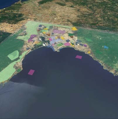
Carmela Gargiulo   Corrado Zoppi
                     Editors

Planning, Nature and Ecosystem Services

              INPUT aCAdemy 2019
             Conference proceedings

                                      La cooperazione al cuore del Mediterraneo
Planning, nature and ecosystem services / editors Carmela Gargiulo,
 Corrado Zoppi - Napoli: FedOAPress. 2019 - (Smart City, Urban Planning
 for a Sustainable Future. 5).

 Web link:
 http://www.tema.unina.it/index.php/tema/Monographs

 ISBN: 978-88-6887-054-6
 DOI: 10.6093/978-88-6887-054-6

Editor
Rocco Papa, University of Naples Federico II, Italy

Editorial Advisory Board
Mir Ali, University of Illinois, USA - Luca Bertolini, Universiteit van Amsterdam, Paesi Bassi - Luuk
Boelens, Ghent University, Belgium - Dino Borri, Politecnico di Bari, Italia - Enrique Calderon,
Universidad Politécnica de Madrid, Spagna - Roberto Camagni, Politecnico di Milano, Italia - Derrick
De Kerckhove, University of Toronto, Canada - Mark Deakin, Edinburgh Napier University, Scotland
- Aharon Kellerman, University of Haifa, Israel - Nicos Komninos, Aristotle University of
Thessaloniki, Grecia - David Matthew Levinson, University of Sydney, Australia - Paolo Malanima,
Magna Græcia University of Catanzaro, Italy - Agostino Nuzzolo, Università degli Studi di Roma Tor
Vergata, Italia - Rocco Papa, Università degli Studi di Napoli Federico II, Italia - Serge Salat, Urban
Morphology and Complex Systems Institute, France - Mattheos Santamouris, National Kapodistrian
University of Athens, Greece - Ali Soltani, Shiraz University, Iran

Selection and double blind review under responsibility of INPUT aCAdemy 2019
Conference Committee

© 2019 FedOAPress - Federico II Open Access University Press
Università degli Studi di Napoli Federico II
Centro di Ateneo per le Biblioteche “Roberto Pettorino”
Piazza Bellini 59-60 - 80138 Napoli, Italy
http://www.fedoapress.unina.it

Published in Italy
Gli E-Book di FedOAPress sono pubblicati con licenza
Creative Commons Attribution 4.0 International

Cover and graphic project: TeMALab
This book collects the papers presented at INPUT aCAdemy 2019, a special edition of the INPUT
Conference hosted by the Department of Civil and Environmental Engineering, and Architecture (DICAAR)
of the University of Cagliari.
INPUT aCAdemy Conference will focus on contemporary planning issues with particular attention to
ecosystem services, green and blue infrastructure and governance and management of Natura 2000 sites
and coastal marine areas.
INPUT aCAdemy 2019 is organized within the GIREPAM Project (Integrated Management of Ecological
Networks through Parks and Marine Areas), co-funded by the European Regional Development Fund
(ERDF) in relation to the 2014-2020 Interreg Italy – France (Maritime) Programme.
INPUT aCAdemy 2019 is supported by Società Italiana degli Urbanisti (SIU, the Italian Society of Spatial
Planners), Istituto Nazionale di Urbanistica (INU, the Italian National Institute of Urban Planning), UrbIng
Ricerca Scientifica (the Association of Spatial Planning Scholars of the Italian Schools of Engineering) and
Ordine degli Ingegneri di Cagliari (OIC, Professional Association of Engineers of Cagliari).

S CIENTIFIC C OMMITEE                                     L OCAL C OMMITEE

Dino Borri - Politecnico di Bari                          Ginevra Balletto - Università di Cagliari
Marta Bottero - Politecnico di Torino                     Ivan Blecic - Università di Cagliari
Domenico Camarda - Politecnico di Bari                    Michele Campagna - Università di Cagliari
Arnaldo Cecchini - Università degli Studi di Sassari      Ignazio Cannas - Università di Cagliari
Donatella Cialdea - Università del Molise                 Anna Maria Colavitti - Università di Cagliari
Giovanni Colombo - ISMB Istituto Superiore Mario Boella   Sebastiano Curreli - Università di Cagliari
Valerio Cutini - Università di Pisa                       Maddalena Floris - Università di Cagliari
Andrea De Montis - Università degli Studi di Sassari      Chiara Garau - Università di Cagliari
Romano Fistola - Università degli Studi del Sannio        Federico Isola Università di Cagliari
Carmela Gargiulo - Università di Napoli “Federico II”     Sabrina Lai – Regione Autonoma della Sardegna
Davide Geneletti - University of Trento                   Francesca Leccis - Università di Cagliari
Roberto Gerundo - Università degli Studi di Salerno       Federica Leone - Università di Cagliari
Paolo La Greca - University of Catania                    Anania Mereu - Università di Cagliari
Daniele La Rosa - University of Catania                   Marianna Agostina Mossa – Regione Sardegna
Giuseppe Las Casas - University of Basilicata             Salvatore Pinna - Università di Cagliari
Antonio Leone - Tuscia University                         Cheti Pira - Università di Cagliari
Sara Levi Sacerdotti - SITI                               Daniela Ruggeri - Università di Cagliari
Giampiero Lombardini - Università degli Studi di Genova   Laura Santona – Regione Sardegna
Stefania Mauro - SITI                                     Corrado Zoppi - Università di Cagliari
Giulio Mondini - Politecnico di Torino
Beniamino Murgante - University of Basilicata
Silvie Occelli - IRES Piemonte
Rocco Papa - Università di Napoli “Federico II”
Raffaele Pelorosso - Tuscia University
Alessandro Plaisant - Università degli Studi di Sassari
Bernardino Romano - Università degli Studi dell'Aquila
Francesco Scorza - University of Basilicata
Maurizio Tira - University of Brescia
Angioletta Voghera - Politecnico di Torino
This book is the most recent scientific contribution of the “Smart City, Urban Planning for a Sustainable
Future” Book Series, dedicated to the collection of research e-books, published by FedOAPress -
Federico II Open Access University Press. The volume contains the scientific contributions presented at
the INPUT aCAdemy 2019 Conference. In detail, this publication, including 92 papers grouped in 11
sessions, for a total of 1056 pages, has been edited by some members of the Editorial Staff of “TeMA
Journal”, here listed in alphabetical order:
– Rosaria Battarra;
– Gerardo Carpentieri;
– Federica Gaglione;
– Carmen Guida;
– Rosa Morosini;
– Floriana Zucaro.
The most heartfelt thanks go to these young and more experienced colleagues for the hard work done
in these months. A final word of thanks goes to Professor Roberto Delle Donne, Director of the CAB -
Center for Libraries "Roberto Pettorino" of the University of Naples Federico II, for his active availability
and the constant support also shown in this last publication.

Rocco Papa
Editor of the Smart City, Urban Planning for a Sustainable Future” Book Series
Published by FedOAPress - Federico II Open Access University Press
Table of contents

Introduction                                                                             15
Corrado Zoppi

Sessione 1 - Ecosystem services and spatial planning

The Danube Riverside Development in the Iron Gates Gorge, Serbia, between                17
Socio-economic needs and Protected Ecosystem
Branislav Antonić, Aleksandra Djukić, Milica Cvetanović

From a species-centred to an ecosystem-based management approach, a case                 29
study of the saltmarshes of Hyères (Provence, France)
Patrick Astruch, Charles-François, Boudouresque, Thomas Changeux et al.
Spatial evolutions between identity values and settlements changes. Territorial          39
analyses oriented to the landscape regeneration
Donatella Cialdea
Analyzing senior tourism. The role of ecosystem services to improve sustainable          52
tourism destinations
Romano Fistola, Rosa Anna La Rocca
Carbon sequestration and land-taking processes. A study concerninig Sardinia             66
Maddalena Floris, Corrado Zoppi
The impact of urbanization processes in landscape fragmentation. A comparison            80
between coastal zones of Sardinia and Liguria
Giampiero Lombardini, Andrea De Montis, Vittorio Serra
Areas of considerable public interest, territorial common goods and ecosystem            86
services: an application case for the city of Cagliari
Marzia Morittu, Alessandro Plaisant
A bottom up initiatives for biodiversity: ecologic representation for the inner areas    98
of Sardinia
Giuseppe Roccasalva
The soil matter between eco-systemic performance and spatial planning in                111
metropolitan areas
Saverio Santangelo, Paolo De Pascali, Annamaria Bagaini, Clara Musacchio,
Francesca Perrone
Knowledge-building models for environmental planning: the case study of Bari            120
Stefania Santoro, Domenico Camarda, Pasquale Balena
From Ecosystems to Ecosystem Services. A spatial methodology applied to a case          130
study in Sardinia
Matilde Schirru, Simona Canu, Laura Santona , Sabrina Lai, Andrea Motroni
Table of contents

Session: 2 - Integrated management of marine protected areas
and Natura 2000 sites

Organize the management of protected areas according to an optimal framework.               142
Experimental case
Aicha Bouredji
A methodological approach to build a planning environmental assessment                      152
framework in the context of marine protected areas
Ignazio Cannas, Daniela Ruggeri
An experimental methodology for the management of marine protected areas                    165
Maddalena Floris, Federica Isola, Cheti Pira
Marine Forests (Fucales, Ochrophyta) in a low impacted Mediterranean coastal                176
area: current knowledge and future perspectives. A phycological review in Sinis
Peninsula and the Gulf of Oristano (Sardinia Island, Italy)
Daniele Grech, Luca Fallati, Simone Farina, David Cabana, Ivan Guala
Assessing the potential Marine Natura 2000 sites to produce ecosystem-wide                  185
effects in rocky reefs: a case study from Sardinia Island (Italy)
Paolo Guidetti; Pierantonio Addis; Fabrizio Atzori et al.
Bottlenecks in fully implementing the Natura 2000 network in Italy. An analyisis of         201
processes leading to the designation of Special Areas of Conservation
Sabrina Lai
Urban pressure scenario on the protected areas systems. The case study of                   212
Teatina adriatic coast
Alessandro Marucci, Lorena Fiorini, Carmen Ulisse
Posidonia banquettes on the Mediterranean beaches: To what extent do local                  225
administrators’ and users’ perceptions correspond?
Paolo Mossone, Ivan Guala, Simone Simeone
The ecosystem services cascade perspective in practice: a framework for cost-               235
benefits analysis in Marine Protected Areas. The study case of Portofino Marine
Protected Areas
Chiara Paoli, Paolo Povero, Giorgio Fanciulli et al.
The contribution of the assessment of policy consistency and coherence to the               251
definition of the legistative provisions of marine protected areas. The examples of
the regulations of “Tavolara-Punta Coda Cavallo” and “Isola dell’Asinara”
Salvatore Pinna, Francesca Leccis
Passive acoustics to monitor flagship species near boat traffic in the Unesco world         260
heritage natural reserve of Scandola
Marion Poupard, Maxence Ferrari, Jan Schlüter et al.
Use of ecological indices to assess the health status of Posidonia oceanica                 271
meadows in the Eastern Liguria. Influence of ecological status on natural capital
Ilaria Rigo, Monica Montefalcone, Carla Morri et al.
Coastal governance and planning agreements for integrated management of                     281
marine protected areas in UE coasting project
Saverio Santangelo, Paolo De Pascali, Maria Teresa Cutrì et al.

PLANNING, NATURE AND                                8                      ISBN: 978-88-6887-054-6
ECOSYSTEM SERVICES                                                  DOI: 10.6093/978-88-6887-054-6
                                                                                © 2019, FedoaPress
Table of contents
Innovative management tools to survey boat traffic and anchoring activities 292
within a Marine Protected Area
Thomas Schohn, Patrick Astruch, Elodie Rouanet et al.
SHADES. Sustainable and holistic approaches to development in European 302
seabords
Francesco Vita, Fortunato Cozzupoli
Session 3 - Rural development and conservation of nature and
natural resources
New local projects for disadvantged inner areas. From traditional model to bio- 312
regional planning
Anna Maria Colavitti, Alessio Floris, Francesco Pes et al.
Inclusion of migrants for rural regeneration through cultural and natural heritage 323
valorization
Elisa Conticelli, Claudia de Luca, Aitziber Egusquiza et al.
Environmental and social sustainability of the bioenergy supply chain 333
Sebastiano Curreli
Proposals on the Agricultural Land Use in According to the Features of the 345
landscape: The case study of Sardinia (Italy)
Pasquale Mistretta, Giulia Desogus, Chiara Garau
Common land(scape): morphologies of a multifunctional rural landscape in the 356
Isalle Valley, Sardinia
Roberto Sanna
SheepToShip LIFE: Integration of environmental strategies with rural 366
development policies. Looking for an eco-sustainable sheep supply chain
Enrico Vagnoni, Alberto Atzori, Giovanni Molle et al.
Session 4 - Geodesign, planning and urban regeneration
The territorial planning of European funds as a tool for the enhancement and 375
sustainable development of natural areas: the experience of the Strategic
Relevance Areas of the ERDF OP 2014-2020
Stefania Aru, Sandro Sanna
The International Geodesign Collaboration: the Cagliari case study 385
Michele Campagna, Chiara Cocco, Elisabetta Anna Di Cesare
A geodesign collaboration for the mission valley project, San Diego, USA 399
Chiara Cocco, Bruce Appleyard, Piotr Jankowski
University and urban development: The role of services in the definition of 410
integrated intervention policies
Mauro Francini, Sara Gaudio, Annunziata Palermo, Maria Francesca Viapiana
PLANNING, NATURE AND 9 ISBN: 978-88-6887-054-6
ECOSYSTEM SERVICES DOI: 10.6093/978-88-6887-054-6
© 2019, FedoaPressTable of contents
Urban environment. An analysis of the Italian metropolitan cities 419
Giuseppe Mazzeo
Recycled aggregates. Mechanical properties and environmental sustainability 431
Luisa Pani, Lorena Francesconi, James Rombi et al.
Geodesign fast-workshops evidences. On field applications of collaborative design 443
approach for strategic planning and urban renovation
Francesco Scorza
Session 5 - Green and blue infrastructure
Green infrastructure as a tool of urban regeneration, for an equitable and 453
sustainable planning. An application case at l'Eixample, Barcelona
Clara Alvau Morales, Tanja Congiu, Alessandro Plaisant
The value of water: ecosystem services trade-offs and synergies of urban lakes in 465
Romania
Denisa Lavinia Badiu, Cristian Ioan IojĂ, Alina Constantina Hossu et al.
A blue infrastructure: from hydraulic protection to landscape design. The case 476
study of the village of Ballao in the Flumendosa river valley
Giovanni Marco Chiri, Pino Frau, Elisabetta Sanna et al.
Municipal masterplans and green infrastructure. An assessment related to the 488
Metropolitan Area of Cagliari, Italy
Sabrina Lai, Federica Leone, Corrado Zoppi
The Ombrone river contract: A regional design practice for empowering river 502
communities and envisioning basin futures
Carlo Pisano, Valeria Lingua
Green infrastructures in the masterplan of Rome. Strategic components for an 513
integrated urban strategy
Laura Ricci, Carmela Mariano, Irene Poli
Session 6 - Smart city planning
Smart City Governance for Child-friendly Cities: Impacts of Green and Blue 524
Infrastructures on Children's Independent Activities
Alfonso Annunziata, Chiara Garau
Resilience, smartness and sustainability. Towards a new paradigm? 539
Sabrina Auci, Luigi Mundula
Energy autonomy in symbiosis with aesthetics of forms in architecture 549
Pietro Currò
Sharing governance and new technologies in smart city planning 563
Paolo De Pascali, Saverio Santangelo, Annamaria Bagaini et al.
PLANNING, NATURE AND 10 ISBN: 978-88-6887-054-6
ECOSYSTEM SERVICES DOI: 10.6093/978-88-6887-054-6
© 2019, FedoaPressTable of contents
Smart Mapping Tools for the Balanced Planning of Open Public Spaces in the 573
Tourist Town of Golubac, Serbia
Aleksandra Djukić, Branislav Antonić, Jugoslav Joković, Nikola Dinkić
Towards a model for urban planning control of the settlement efficiency 587
Isidoro Fasolino, Francesca Coppola, Michele Grimaldi
Somerville: Innovation City 595
Luna Kappler
Urban regeneration for smart communities. 605
Caterina Pietra, Elisabetta Maria Venco
Energy autonomy as a structural assumption for systemic development and 619
circular economy
Manlio Venditelli
Session 7 - Water resources, ecosystem services and nature-
based solutions in spatial planning
Landscape and species integration for a nature-based planning of a 630
Mediterranean functional urban area
Erika Bazzato, Michela Marignani
Tourism and natural disasters: integrating risk prevention methods into the Plan 640
for tourism
Selena Candia, Francesca Pirlone
Integrated management of water resources. An operative tool to simplify, direct 649
and measure the interventions
Vittoria Cugusi, Alessandro Plaisant
Application of NbS to the city plan of Segrate Municipality: spatial implications 660
Roberto De Lotto
Nature-Based Solutions impact assessment: a methodological framework to 671
assess quality, functions and uses in urban areas
Claudia De Luca, Simona Tondelli
The recognition of the Aspromonte National Park ecosystem networks in the 679
urban structure project of Metropolitan City of Reggio Calabria
Concetta Fallanca, Natalina Carrà, Antonio Taccone
Shaping the urban environment for breathable cities. 692
Michela Garau, Maria Grazia Badas, Giorgio Querzoli, Simone Ferrari,
Alessandro Seoni, Luca Salvadori
Defense, adaptation and relocation: three strategies for urban planning of coastal 704
areas at risk of flooding
Carmela Mariano, Marsia Marino
Thermal Urban Natural Environment Development 714
Francesca Moraci, Celestina Fazia, Maurizio Francesco Errigo
PLANNING, NATURE AND 11 ISBN: 978-88-6887-054-6
ECOSYSTEM SERVICES DOI: 10.6093/978-88-6887-054-6
© 2019, FedoaPressTable of contents
A network approach for studying multilayer planning of urban green areas: a case 723
study from the town of Sassary (Sardegna, Italy)
Maria Elena Palumbo, Sonia Palumbo, Salvatore Manca, Emmanuele Farris
Urban areas morphometric parameters and their sensitivity on the computation 734
method
Luca Salvadori, Maria Grazia Badas, Michela Garau, Giorgio Querzoli, Simone
Ferrari
Session 8 - Conservation and valorisation of architectural and
cultural heritage
Preservation and valorisation of small historic centers at risk 744
Maria Angela Bedini, Fabio Bronzini, Giovanni Marinelli
Material and immaterial cultural heritage: identification, documentation, 757
promotion and valorization. The courtyards and hallways of merit in the
Murattiano district of Bari
Antonia Valeria Dilauro, Remo Pavone, Francesco Severino
Planning of historic centers in Sardinia Region: conservation versus valorization of 767
architectural and cultural heritage
Federica Isola, Federica Leone, Cheti Pira
Approach towards the "self-sustainability" of ancient villages 776
Francesca Pirlone, Ilenia Spadaro
Fostering architecture efficiency through urban quality. A project for via Milano 787
site in Brescia
Michela Tiboni, Francesco Botticini
Session 9 - Accessibility, mobility and spatial planning
The role of community enterprises in spatial planning for low density territories 800
Cristian Cannaos, Giuseppe Onni
Measuring multimodal accessibility at urban services for the elderly. An 810
application at primary health services in the city of Naples
Gerardo Carpentieri, Carmen Guida, Housmand Masoumi
Urban accessibility for connective and inclusive living environments. An 826
operational model at support of urban planning and design practice
Tanja Congiu, Elisa Occhini, Alessandro Plaisant
Improving accessibility to urban services for over 65: a GIS-supported method 839
Carmela Gargiulo, Floriana Zucaro, Federica Gaglione, Luigi Faga
Cycle networks in Natura 2000 sites: the environmental assessment of the 851
Regional Cycling Plan of Sardinia, Italy
Italo Meloni, Elisabetta Anna Di Cesare, Cristian Saba
PLANNING, NATURE AND 12 ISBN: 978-88-6887-054-6
ECOSYSTEM SERVICES DOI: 10.6093/978-88-6887-054-6
© 2019, FedoaPressTable of contents
Improving regional accessibility through planning a comprehensive cycle network: 859
the case of Sardinia (Italy)
Italo Meloni, Cristian Saba, Beatrice Scappini et al.
Vehicle routing problem and car-pooling to solve home-to-work transport problem 869
in mountain areas
Antonio Pratelli, Massimiliano Petri
Session 10 - Tourism and sustainability in the Sulcis area
Wave, walk and bike tourism. The case of Sulcis (Sardinia -Italy) 881
Ginevra Balletto, Alessandra Milesi, Luigi Mundula, Giuseppe Borruso
Smart Community and landscape in progress. The case of the Santa Barbara walk 893
(Sulcis, Sardinia)
Ginevra Balletto, Alessandra Milesi, Stefano Naitza et al.
A Blockchain approach for the sustainability in tourism management in the Sulcis 904
area
Gavina Baralla, Andrea Pinna, Roberto Tonelli et al.
People and heritage in low urbanised settings: An ongoing study of accessibility 920
to the Sulcis area (Italy)
Nađa Beretić, Tanja Congiu, Alessandro Plaisant
Place branding as a tool to improve heritage-led development strategies for a 928
sustainable tourism in the Sulcis-Iglesiente region
Anna Maria Colavitti, Alessia Usai
Walkability as a tool for place-based regeneration: the case study of Iglesiente 943
region in Sardinia (Italy)
Chiara Garau, Gianluca Melis
The use of recycled aggregates in the implementation of Municipal Masterplans 955
and Coastal Land-Use Plans. A study concerning Sulcis (Sardinia, Italy)
Federica Leone, Anania Mereu
Relationships between conservation measures related to Natura 2000 sites and 971
coastal land use plans: a study concerning Sulcis (Sardinia, Italy)
Federica Leone, Corrado Zoppi
A Smart Planning tools for the valorisation of the Carbonia's building heritage via 983
an energy retrofitting based approach
Stefano Pili, Francesca Poggi, Eusebio Loria, Caterina Frau
Special session 1 - Ecological networks and landscape planning
Resilient ecological networks. A comparative approach 995
Andrea De Montis, Amedeo Ganciu, Maurizio Mulas et al.
PLANNING, NATURE AND 13 ISBN: 978-88-6887-054-6
ECOSYSTEM SERVICES DOI: 10.6093/978-88-6887-054-6
© 2019, FedoaPressTable of contents
A complex index of landscape fragmentation: an application to Italian regional 1007
planning
Andrea De Montis, Amedeo Ganciu, Vittorio Serra
Measuring landscape fragmentation in Natura 2000 sites. A quantitative and 1017
comparative approach
Antonio Ledda, Andrea De Montis, Vittorio Serra
Regional ecological networks: theoretical and practical issues 1028
Giuseppe Modica, Salvatore Praticò, Luigi Laudari et al.
Comparative ecological network analysis. Target and vector species and other 1038
naturalistic issues
Maurizio Mulas, Matteo Cabras, Andrea De Montis
Measuring connectivity in Natura 2000 sites. An application in Sardinia 1049
Vittorio Serra, Andrea De Montis, Antonio Ledda
PLANNING, NATURE AND 14 ISBN: 978-88-6887-054-6
ECOSYSTEM SERVICES DOI: 10.6093/978-88-6887-054-6
© 2019, FedoaPressIntroduction
INTRODUCTION
This e-book contains the Proceedings of the INPUT aCAdemy 2019 Conference held at the
University of Cagliari on 24-26 June 2019, titled “Planning, nature and ecosystem services.”
Input aCAdemy follows the tenth INPUT Conference, held in September 2018 at Tuscia
University, in Viterbo and, in some way, it breaks the biennial tradition of the INPUT
Conferences. The reason for the frequency increase of the INPUT Conferences is that the
Department of Civil and Environmental Engineering and Architecture of the University of
Cagliari is involved in a project funded by the Programme INTERREG Marittimo–Italia
France–Maritime 2014–2020, Axis 2.
In the context of the project, entitled “GIREPAM–Integrated Management of Ecological
Networks through Parks and Marine Areas”, the Department and the Office for Nature
Protection and forest policies of the Regional Autonomous Administration of Sardinia are
studying and defining an experimental methodology to integrate conservation measures
concerning Natura 2000 Sites into marine protected areas regulations. The methodology is
implemented to build the new regulations of two marine protected areas of Sardinia, namely
the Island of Asinara and of the Island of Tavolara and Cape Coda Cavallo.
Since GIREPAM allocates a considerable amount of funds to the organization of an
international conference on protection of nature and natural resources, ecosystem services
and their relationship with spatial planning processes and practices, green infrastructure,
and integrated management of protected areas and Natura 2000 Sites, and these funds
must be spent by December 2019, the research group at the Department proposed to the
INPUT Community, during the 2018 Viterbo Conference, a 2019 INPUT Conference
focussing on these themes. The INPUT Community responded enthusiastically and, that
being so, the research group has made every effort to make the event come true.
The Conference develops through plenary sessions and parallel tracks. The scope of the
plenary sessions is to propose distinguished points of view concerning research and implied
planning ideas and policies on important and significant issues which feature the ongoing
scientific and technical debate on nature and natural resources.
The questions proposed and discussed in the Conference are three central topics which are
characterized by several studies available in contemporary literature, and by vibrant debates
as well, both from the theoretical and technical points of view. These questions are
presented and discussed in the three plenary sessions which are the starting points of the
three days of the Conference. Each plenary session is organized as follows: first, a speaker,
a distinguished scholar, proposes the findings of his theoretical and/or applied research
work and derived implications for spatial policy; secondly, a discussant, a distinguished
PLANNING, NATURE AND 15 ISBN: 978-88-6887-054-6
ECOSYSTEM SERVICES DOI: 10.6093/978-88-6887-054-6
© 2019, FedoaPressCorrado Zoppi
scholar as well, critically analyzes the positions expressed in the first place and identifies
open or unresolved questions and outstanding issues; thirdly, the public enters the
discussion, through questions, observations, critical positions. Finally, the speaker replies to
the discussant’s and to the public’s statements.
The first plenary session is on “Valuing ecosystem services in money: A necessary evil for
protecting biodiversity?”; the speaker is Erik Gomez-Baggethun (Faculty of Landscape and
Society, Norwegian University of Life Sciences); the discussant is Andrea Arcidiacono
(Department of Architecture and Urban Studies, Polytechnic University of Milan).
The second plenary session concerns “Managing urban ecosystems for goods and services”;
the speaker is Kevin Gaston (Environment and Sustainability Institute, University of Exeter);
the discussant is Bernardino Romano (Department of Civil, Building-Architecture and
Environmental Engineering, University of L’Aquila).
The third plenary session is related to “Mapping and modeling ecosystem services: A
cascade ES modeling approach applied to the Flemish Natura 2000 Network”; the speaker is
Jan Staes (Department of Biology, University of Antwerp); the discussant is Beniamino
Murgante (School of Engineering, University of Basilicata at Potenza).
The topics presented in the plenary sessions are the background of the discussions which
characterize the parallel tracks. These tracks are featured by studies which consider
protection of nature and natural resources, ecosystem services and their relationship with
spatial planning processes and practices, as regards the following topics:
1. Ecosystem services and spatial planning;
2. Integrated management of marine protected areas and Natura 2000 sites;
3. Rural development and conservation of nature and natural resources;
4. Geodesign, planning and urban regeneration;
5. Green and blue infrastructure;
6. Smart city planning;
7. Water resources planning, ecosystem services and nature-based solutions in spatial
planning;
8. Conservation and valorisation of architectural and cultural heritage;
9. Accessibility, mobility and spatial planning;
10. Tourism and sustainability in the Sulcis area;
11. Ecological networks and landscape planning.
The closing plenary session of the Conference proposes a roundtable discussion on
“Planning Nature 2000 Network and protected areas: The integration of conservation
measures into regulations.” The roundtable will involve panelists from several institutions
who participate in the GIREPAM Project.
PLANNING, NATURE AND 16 ISBN: 978-88-6887-054-6
ECOSYSTEM SERVICES DOI: 10.6093/978-88-6887-054-6
© 2019, FedoaPressTHE INTERNATIONAL GEODESIGN
COLLABORATION
THE CAGLIARI CASE STUDY
MICHELE CAMPAGNA, CHIARA COCCO
ELISABETTA ANNA DI CESARE
Department of Civil and Environmental
Engineering and Architecture
University of Cagliari, Italy
e-mail: campagna@unica.it
URL: http://people.unica.it/urbangis
How to cite item in APA format:
Campagna, M., Cocco, C., & Di Cesare, E.A. (2019). The International Geodesign Collaboration. The Cagliari
case study. In C. Gargiulo & C. Zoppi (Eds.), Planning, nature and ecosystem services (pp. 385-398). Naples:
FedOAPress. ISBN: 978-88-6887-054-6, doi: 10.6093/978-88-6887-054.6
ABSTRACT
This paper presents a two-scales geodesign study of the Metropolitan City of Cagliari developed
according the International Geodesign Collaboration (IGC) guidelines and standards. As such,
the study aims at contributing to the broader IGC research questions concerning how the
geodesign approach to spatial planning can help addressing the most urgent complex challenges
of sustainable development. After an introduction on the main key-features of the IGC initiative,
the case study is presented in terms of the design approach and workflow. The paper concludes
with a discussion on what lesson can be learnt from applying the geodesign approach with
regard to planning education and practice.
KEYWORDS
Geodesign; International Geodesign Collaboration; Collaborative Decision Process, Systems
ThinkingM. Campagna, C. Cocco, E. A. Di Cesare
1 INTRODUCTION
Geodesign is a novel approach to spatial planning and design aiming at addressing current
challenges of spatial development. Geodesign methods relie on extensive use of spatial
information technologies to support collaborative, iterative, and dynamic design and spatial
decision-making. Thanks to the use of state-of-the-art GIS technologies and Planning Support
Systems, geodesign workflows proved to be successful in framing processes facilitating fast
awareness-rising and achievement of consensus among participants in the strategic phases
of spatial planning (Steinitz, 2017). In addition, geodesign can support all the design phases
from project inception to the detailed design of implementation plans and projects (Moreno
Marimbaldo et al., 2018). As a part of an international initiative aimed at fostering geodesign
research worldwide, this paper reports on a geodesign study undertaken on the Metropolitan
City of Cagliari (MCC) according to the International Geodesign Collaboration (IGC) guidelines.
The IGC is an international geodesign research initiative started in 2018 aiming at building
and facilitating the sharing of knowledge on the possible ways to address major sustainability
challenges of current time. The means envisaged to achieve this ambitious objective are
standardization and sharing. Accordingly, almost one hundred partners, mostly from
academia, from all over the world joined the IGC, and along 2018 the partners completed 56
studies of local planning and design at various scales. The results were presented at the first
IGC meeting held in February 2019 in Redlands, CA, and hosted by ESRI.
The IGC standards for the geodesign studies include:
− modular size for the study areas at various scales (i.e. double multiples of 0.5 km);
− a set of Global Assumptions, which identify major current global dynamics (e.g. global
population growth, climate changes, sea-level rise, etc.1) to be studied in their local
influence in the selected study areas;
− a standard number of 9 Systems to be analyzed, including blue, green, grey, energy and
transport infrastructures, low-density and mixed high-density housing, institutional and
industry-and-commerce land uses, plus a system to be chosen locally (for the MCC study
History and Cultural Heritage was chosen);
− a set of Technology Innovations to be considered for each system: innovations include
the latest or forthcoming technologies which can introduce technical improvements in
design with regard to each system (e.g. autonomous vehicles or hyper-loops in
1
for a full list of GA see https://www.envizz1.com/global-systems-research.
PLANNING, NATURE AND 386 ISBN: 978-88-6887-054-6
ECOSYSTEM SERVICES DOI: 10.6093/978-88-6887-054-6
© 2019, FedoaPressThe international geodesign collaboration: the Cagliari case study
transport, photovoltaic road pavements in energy production, or green building and 3D
printing in housing);
− a common format for reporting the results of the study, in order to facilitate comparison
among the studies.
There is broad consensus in the geodesign community of researchers and practitioners to
refer to the geodesign framework proposed by Steinitz (Steinitz, 2012) as a flexible though
robust methodology approach for organizing geodesign studies. The Steinitz framework for
geodesign entails the iterative development of six models, the first three of which (i.e.
representation, process, and evaluation model) concern the creation of the knowledge base
for design and decision-making, while the last three (i.e. change, impact, and decision model)
include the creation of design alternatives, the assessment of their impacts, and the creation
of a final design based on consensus. While the representation and the process models entail
the description of current territorial systems dynamics and their likely evolution without any
action, the evaluation model is intended to express an assessment of the current and future
conditions in the study area. The product of the evaluation model is a series of maps
representing less or more favorable settings for action for the territorial systems taken into
account to inform the design, on the base of which change alternatives should be developed
(i.e. the change model). The Steinitz framework for geodesign was applied by the authors to
develop the study of future scenarios for Metropolitan City of Cagliari according to the IGC
guidelines and standards as described in the remainder of this paper.
2 CASE STUDY: FUTURE SCENARIOS FOR THE METROPOLITAN CITY
OF CAGLIARI
The recently established (2016) Metropolitan City of Cagliari comprehends seventeen
municipalities of South Sardinia (Italy), including Cagliari, the regional capital. The population
is approximately 430k inhabitants, in an area of 1,248 km². The area is surrounded by
mountains to the East and on the West, by the Gulf of Cagliari to the South, and by the
agricultural Campidano plain to the North. In 2018, the MCC started the works for its first
planning initiative, the Territorial Strategic Plan, which is going to set the development
framework for future physical planning. However, to date, no inter-municipal planning
endeavor has ever been carried on in the region. Hence, developing a new strategic plan for
the area represents a challenge and an opportunity for innovation, both in technical, political
and socio-cultural terms for the local community. This study represents a first attempt to
propose a working framework for reasoning on possible future development scenarios, in line
with the IGC assumptions and perspectives, on territorial technology innovation.In the last
PLANNING, NATURE AND 387 ISBN: 978-88-6887-054-6
ECOSYSTEM SERVICES DOI: 10.6093/978-88-6887-054-6
© 2019, FedoaPressM. Campagna, C. Cocco, E. A. Di Cesare
decades, the MCC faced overall stable trends in population growth, affected mainly by a
limited movement of population from the inner small towns of Sardinia and very limited
immigration flows; meanwhile the Municipality of Cagliari lost approximately 30% inhabitants
in favor of neighboring municipalities within a 15-20 km radius, due possibly to market
dynamics related to real estate prices. As a major challenge for future coherent and balanced
development, the MCC needs to balance spatial development patterns in terms of
infrastructures and services, as well as ensuring environmental and economic sustainability.
In order to explore possible scenarios for the MCC future sustainable development, two
workshops (WS) applying the guidelines of the IGC were organized as design studio exercise
at the Department of Civil and Environmental Engineering and Architecture of the University
of Cagliari. The WS were conducted in October 2018 using the Geodesignhub planning support
system (Ballal, 2015), after the set of evaluation maps was created in August 2018 as a
preparatory phase of the study by the authors, using ESRI ArcGIS. The first WS was held
within the Spatial Planning Course of the Civil Engineering MSc program, concerned a study
area of 80x80 Km including the whole MCC (Fig. 1), and involved 58 students. The second
WS was held within the Geodesign course of the Architecture BSc program, concerned a
nested area of 20x20 Km (Fig. 1), and involved 76 students. Running two WS in sequence
allowed to experiment the change of scale in the design as the architecture students had to
comply with the design earlier developed by the engineering students. A number of underlying
local assumptions were considered to inform the study.
Fig. 1. Case Study areas: a) the first study concerned the whole MCC area (80x80 km);
the second-high scale study, concerned the South-East area (20x20 km)
PLANNING, NATURE AND 388 ISBN: 978-88-6887-054-6
ECOSYSTEM SERVICES DOI: 10.6093/978-88-6887-054-6
© 2019, FedoaPressThe international geodesign collaboration: the Cagliari case study
A population growth of 25k and 50k inhabitants was assumed as baseline scenario in order to
set quantitative targets for the ten systems, where possible. In addition, a number of
objectives were adopted to inform the creation of the evaluation and change models with
regard to each system, as described below:
− water Infrastructure (WATER): reduce hydrological risk and limit pollution of resources.
− agriculture (AGRI): protect prime soils, promote bio products and foster innovation in
production to address desertification processes, climate change, and possible future
shortage of water.
− green infrastructure (GREEN): enhance connectivity and expand protection to natural or
semi-natural areas.
− energy: increase green production through technology innovation, promote local
production.
− transport infrastructure: improve accessibility to most populated areas and the level of
service of current road infrastructure. Improve the light-rail network. Foster active
travelling in recreation, leisure and cultural heritage accessibility.
− industry and commerce (INDUSTRY): promote technology innovation in production and
balance spatial distribution within the MCC to reduce workers commuting.
− residential lower density (LDH): accommodate demography growth limiting
fragmentation and sprawl;
− residential with commerce and services (MIX): accommodate demography growth with
densification and enhance accessibility to commerce and services.
− institutional (INST): promote locational accessibility and balanced spatial distribution.
− cultural heritage (CULTH): preserve historic centers and protect archaeological sites
while enhancing fruition.
Following the Steinitz framework, ten evaluation maps – one for each system - were created
following standard legend and color code (Fig. 2) to facilitate their understanding and usage
by the participants. The color code use the “traffic lights” metaphor were red means “stop”
(i.e. the system is working well and no action is needed), yellow means “alert” (i.e. it is not
advisable to take any action due to constraints or hindering factors), and different shade of
green means growing levels of suitability for actions within each system (the darker the green,
the more suitable).
PLANNING, NATURE AND 389 ISBN: 978-88-6887-054-6
ECOSYSTEM SERVICES DOI: 10.6093/978-88-6887-054-6
© 2019, FedoaPressM. Campagna, C. Cocco, E. A. Di Cesare
Fig. 2. Set of evaluation maps (i.e. one for each system)
3 GEODESIGN WORKSHOP SETTINGS
Two geodesign workshops were organized, one for each case study area. Each workshop was
scheduled in five 3-hour sessions (Fig. 3), according to the following steps: 1) design of project
and policies (i.e. diagrams); 2-4) iterative design of integrated syntheses (i.e. scenarios), 5)
negotiation. The workshops were supported by the Geodesign hub planning support system
(www.geodesignhub.com). Geodesign hub is a web-based collaborative geodesign platform
where each participant joins a virtual planning studio workspace offering interactive design
and decision-making tools needed to carry-on the workshop workflow.
Fig. 3 Geodesign workshop process model
In the first phase (i.e. step 1) participants played the role of experts in one system (e.g.
transport planners or engineers, housing experts, etc.) whose duty was to produce three
diagrams each: diagrams had to represent projects implementable respectively with
PLANNING, NATURE AND 390 ISBN: 978-88-6887-054-6
ECOSYSTEM SERVICES DOI: 10.6093/978-88-6887-054-6
© 2019, FedoaPressThe international geodesign collaboration: the Cagliari case study
technologies available at the three time horizons chosen for the study by IGC (i.e. 2020, 2035,
and 2050).
The rationale behind this step was to get the participant familiar with possible technologies
able to bring innovation to projects in their system. All the diagrams were saved and shared
in Geodesignhub in a matrix organized by system (column) and color-coded accordingly (Fig.
4, right). It should be noted that Geodesignhub takes, as input layers for its geographic
interface, the evaluation maps developed prior to the WS, which can be used as mash-up
overlay to support locational choices during the design of a diagram (Fig. 4, left).
Fig. 4 (Left) Diagram creation in Geodesignhub; (right) the shared diagrams matrix
In the second phase (i.e. steps 2-4) participants developed their integrated design, or
syntheses, under different assumptions and requirements which were set-up to explore
possible development scenario alternatives depending on time horizons (i.e. 2020, 2035, and
2050), rate of technology innovation, and likely growth dynamics (Tab. 1).
TEAM DEVELOPMENT TIME TECHNOLOGY POPULATION FORECAST
SCENARIO HORIZON INNOVATION
EA35 Early Adopter 2035 Available 2035 + 25K Inhabitants (as-is)
EA50 Early Adopter 2050 Available 2035- + 50K Inhabitants + 10-15% (high
2050 growth)
LA35 Late Adopter 2035 None + 25K Inhabitants + 10-15% (high
growth)
LA50 Late Adopter 2050 Available 2035- + 50K Inhabitants + 10-15% (high
2050 growth)
NA35 Non-Adopter 2035 None + 25K Inhabitants (as-is)
NA50 Non-Adopter 2050 None + 50K Inhabitants (as-is)
Tab. 1 The six scenario-driven change teams
PLANNING, NATURE AND 391 ISBN: 978-88-6887-054-6
ECOSYSTEM SERVICES DOI: 10.6093/978-88-6887-054-6
© 2019, FedoaPressM. Campagna, C. Cocco, E. A. Di Cesare
The teams developed their syntheses, along three dedicated sessions, moving iteratively
between the change and the impact model - or in other words between design and impact
assessment - thanks to the built-in impact model in Geodesignhub.
At the end of the fourth session, the teams presented their syntheses to each other. In the
final session (i.e. step 5), a negotiation was held between the couples of teams having the
same technology rate of adoption and different time horizons (i.e. EA35 and EA 50; LA35 and
LA50; NA35 and NA50). Three final designs resulted from the negotiation process: EA3550,
with the higher level of innovation up-take; LA3550, with an intermediate level of technology
innovation; and NA3550 with little or no technology innovation. Fig. 5 and 6 depict the three
results of the 80x80km and 20x20km studies respectively. Tab. 2 reports a summary of most
used technology innovations2.
Fig. 5 Geodesign workshop results in the 80x80 km study area
3.1 SCENARIOS IN THE 80X80 KM AREA
The Early Adopter (EA) team started locating green Energy Infrastructures (i.e. eolic and
photovoltaic) in the South-North axis to compound existing commercial-industrial land-uses.
The transport network was extended with light rail to enhance connectivity between the
Eastern settlements to the centre and the South East Coast.
2
for a full list of IGC technology innovations see https://www.envizz1.com/global-systems-research
PLANNING, NATURE AND 392 ISBN: 978-88-6887-054-6
ECOSYSTEM SERVICES DOI: 10.6093/978-88-6887-054-6
© 2019, FedoaPressThe international geodesign collaboration: the Cagliari case study
SYSTEM TECHNOLOGY INNOVATIONS
Water Wat 2035 5 waterseer, wat 2035/2050 2 water retention
Agri Agr 2035/2050 1 organic agriculture, agr 2035/2050 5 agroturismo, agr 2035/2050 12
rooftop gardening, agr 2035/2050 15 drones in agriculture
Green Grn 2035/2050 5 integration of vegetation into building design, grn 2035/2050 6
genetically modified trees and engineered trees, grn 2035 12 green roofs
Energy Ene 2035 3 olar roads, ene 2050 12 small wind power on power pylons, ene 2035 4
tidal power
Transport Tra 2035 7 electric autonomous vehicles (eav), tra 2035 13 redefining biking with
bikeshares and e-bikes, tra 2035/2050 5 hyperloop transport, tra 2035 16/17
transportation network with sustainable energy infrastructure
Ind/com Ind/com 2035 8, renewable energy sources, ind/com 2035 2 industrial robotics, ind/com
2035 3d printers and cnc devices
Res Res 2035 1 building integrated solar pv plus storage, res 2050 6 3d printed buildings
and materials
Mix Mix 2035 11 mart city as smart systems, mix 2035 12 innovation districts
Culth Hist/cult1 virtual reality, hist2 smart apps location based services
Tab. 2 Technology innovations
Fig. 6 Geodesign workshop results in the 20x20 km study area
PLANNING, NATURE AND 393 ISBN: 978-88-6887-054-6
ECOSYSTEM SERVICES DOI: 10.6093/978-88-6887-054-6
© 2019, FedoaPressM. Campagna, C. Cocco, E. A. Di Cesare
The Eastern and Western edges were preserved to consolidate existing green infrastructure,
while further industrial development was maintained nearby the existing plants. New areas
for mixed uses and low-density residential areas were located in the central areas with
decreasing intensity of use from the center to the outer edges.
The development for the 2050 was planned to accommodate further demographic growth
aiming at reaching the given target for all the systems.
As results the 2050 design included a central more developed area surrounded by a green
belt. Innovations were considered used in particular to address water (i.e. WAT 2035 5),
energy (e.g. ENE 2035/2050 and ENE 2035 3) and transport (i.e. TRA 2035/2050 5) issues.
The Late Adopter (LA) team started the design considering the Blue Infrastructures and Mixed
use together with Transport infrastructures to address current issues in the central area of
the Metropolitan City. Accessibility and connectivity were considered important as well as
water supply and hydrological risk reduction.
The Eastern and Western areas were preserved mainly as green areas for agriculture and
forest uses. The central development was thought as a network of higher density single or
multifunctional poles. The development for the 2050 was planned to accommodate further
demographic growth aiming at reaching the given target for all the systems. Similarly, to
EA2050 the LA2050 design included a central more developed area surrounded by a green
belt, though with a different use patterns. Innovations were considered in particular to re-
think industry development (i.e. IND/COM 2035 2) transport infrastructure (e.g. TRA 2035 7
and TRA 2035 17) and green energy production (i.e. ENE 2035 3). The Non-Adopter (NA)
team started the design considering the improvement of the Transport and the Blue
Infrastructures of primary importance as well as preservation and management of the rich
Cultural Heritage resources in the area.
Renewable energy and Green Infrastructures were also considered of major importance.
Change patterns reinforce connectivity along the coast aiming at supporting tourism
development. Residential development was distributed in the North-Eastern and Eastern part
of the more developed areas, and more space for green infrastructure and agriculture was
preserved in the West/North-Western and South-Eastern areas respectively. Mixed uses were
preferred to Lower Density Housing in order to contain urban sprawl and soil consumption.
While no substantial technology innovation was considered by the Non-Adopters, technology
changes included the promotion of sustainably building and transport (i.e. promotion of car
and bike sharing), as well recovery of traditional agricultures relying on currently existing
innovation.
PLANNING, NATURE AND 394 ISBN: 978-88-6887-054-6
ECOSYSTEM SERVICES DOI: 10.6093/978-88-6887-054-6
© 2019, FedoaPressThe international geodesign collaboration: the Cagliari case study
Scenarios in the 20x20 km area
The Early Adopter (EA) team developed the first design focusing mainly on coastal and marine
areas, also developing a submarine infrastructure for energy production and a big submarine
crop, responding to the need to increase food production despite water scarcity. They also
provided for a flora coastline protection green infrastructure and a cycle network along the
whole coastline, connecting the archaeological sites of the area, which represent an important
asset for tourism. The restoration of the natural waterways project and the rainwater reuse
project was located in the inland and north-west territory, where the main residential areas
are concentrated, together with industrial plants and services.
In the scenario planned for 2050, agriculture was developed in a large northern area, where
the team located an underground crop. In the Eastern part of territory, they planned two
green parks. They also increased the areas for institutions, low density housing and services
in the western part of the study area and, as a consequence, increased the accessibility
through a complex transport system, including vehicle accessible roads, cycle networks and
an infrastructure for fast magnetic levitation trains.
The Late Adopter (LA) team mainly focused on: preservation of natural resources, through a
green infrastructure policy involving an extended north-east part of the study area, and food
production, through the localization of a great number of organic farms and a submarine crop
in the sea. They also planned for taking advantage of renewable energy sources, through the
creation of a tidal power station.
The low-density residential areas were located in a big central area, while the main services
and industries further north. For the transport system, the team defined sustainable mobility
infrastructures concentrated mainly along the coast, where fast trains and cycle networks
were planned.
In the 2050 scenario they confirmed the initial asset of the study area and planned for further
sustainable transport infrastructures, connecting also the coastal zone with the inland ones.
Also, an increase in renewable energy production system was foreseen, which will meet the
needs of the new residential areas and industries, together with two important blue
infrastructures intended to reduce flood risk.
The Non Adopter (NA) team started localizing three macro areas: a very extended buffer
running from north-east to south-east which includes green infrastructure policies and
projects, a large area dedicated to agriculture land-uses in the north-west, and eventually a
central zone with mixed and residential big areas, mostly located in the coastal part, and
scattered institutional and industry projects. Lastly, in order to connect the macro-areas, they
designed two main routes.
PLANNING, NATURE AND 395 ISBN: 978-88-6887-054-6
ECOSYSTEM SERVICES DOI: 10.6093/978-88-6887-054-6
© 2019, FedoaPressM. Campagna, C. Cocco, E. A. Di Cesare
In the evolved scenario, the three macro areas were confirmed with some minor changes.
The agricultural area were extended to the east part, while in the central area an increased
number of projects were localized, including: low density housing areas in the inland places,
new institutional projects (i.e. the hospital and the university campus), and green energy
infrastructures. Moreover, along the coastal areas, an extended blue infrastructure was
planned in order to canalize the rainwater, to react efficiently against to climate change-
related extreme events (i.e. extreme storms and heavy rainfall) and protect the built-up areas.
4 DISCUSSION AND CONCLUSIONS
The geodesign study presented in this paper is the first example of the application of the IGC
guidelines to the Metropolitan City of Cagliari. The main objectives of the study were to earn
early insights on how the study area reacts to the pressure of the global dynamics which
affect the planet and generate the current challenges to be addressed in planning and design
for sustainable development, and on how technology innovation in infrastructure and land-
uses may affect future sustainable development scenarios. While the results of the intensive
workshops alone may be far to offer final solutions for future planning in the study areas, if
considered together to, and in comparison with, the results of all the other studies undertaken
under the umbrella of the International Geodesign Collaboration, they may offer a rich
knowledge resource for geodesign research. In this sense, all the materials produced in the
first year of the IGC project are open-access and can be used by the partners and by other
researchers as knowledge base for further systematic and comparative investigations, which
will be developed within the future IGC activities.
In addition, the two workshops proved to offer a number of benefits to the participants,
including the coordination team and the workshop participants. They represented a visioning
exercise with regard to possible future sustainable development scenarios for the study areas.
The workshop preparation and implementation supported all the participants in earning a
better understanding of the territorial dynamics and to design collaboratively by applying
systems thinking. This may be considered as much of a value especially where traditional
planning systems are structured by sectors (e.g. regional planning, local land-use planning,
transport planning, energy planning). Geodesign approach seems, in fact, to be particularly
valuable especially in early stages of strategic planning, when the planning actors face new
complex problems and need to build their understanding of inter-related territorial dynamics.
From the teaching perspective, the workshops were very well-received by the participants,
which were students with little or no previous knowledge of both spatial planning and design,
and on using spatial information technologies. The learning curve observed by the instructors
during the sequence of the five WS sessions was surprisingly efficient, and the overall results
PLANNING, NATURE AND 396 ISBN: 978-88-6887-054-6
ECOSYSTEM SERVICES DOI: 10.6093/978-88-6887-054-6
© 2019, FedoaPressThe international geodesign collaboration: the Cagliari case study
were eventually difficult to achieve otherwise in such short time (i.e. 15 hours). The
participants, which were students in civil and environmental engineering and architecture,
also learned a new approach to design which was based on proactive collaborative team-
work. This is peculiar of the geodesign approach, according to which no single planner or
designer may be able anymore, due to the current the increased complexity of territorial
systems, to design alone.
From this, as well from previous experiences of the authors (Campagna et al., 2016) and from
other similar experiences reported in literature (Nyerges et al., 2016; Steinitz, 2017; Rivero
et al., 2017; Zschaber de Araújo et al., 2018), in running geodesign studies and workshops it
seems reasonable to expect that similar benefits can be achieved in the planning practice. In
particular, in such cases as in the Metropolitan City of Cagliari, where planning actors were
traditionally used to plan at the municipal level whereas the institution of the new
metropolitan city requires a shift in perspective for planning at the wide area scale, the
collaborative geodesign workshop with Geodesignhub can represent a novel reliable approach
to foster collaboration, systems thinking and awareness rising, consensus building and
negotiation.
ACKNOWLEDGEMENTS
The authors wish to thank Prof. Carl Steinitz, Prof. Brian Orland, Prof. Thomas Fisher for
coordinating the International Geodesign Collaboration. The authors wish to thank also
Geodesign Hub Pvt. Ltd., Dublin, Ireland for kindly providing the use of the Geodesignhub
planning support system and ESRI Redlands, CA for kindly providing ESRI ArcGIS software
for this project.Chiara Cocco gratefully acknowledges Sardinia Regional Government for the
financial support of her PhD scholarship. (P.O.R. Sardegna F.S.E. Operational Program of the
Autonomous Region of Sardinia, European Social Fund 2014-2020 - Axis III Education and
training, Thematic goal 10, Priority of investment 10ii.).
REFERENCES
Ballal H (2015). Collaborative planning with digital design synthesis. Doctoral dissertation, UCL
(University College London).
Campagna M, Steinitz C, Di Cesare EA, Cocco, C, Ballal H, Canfield T (2016). Collaboration in planning:
the Geodesign approach. Rozwój Regionalny i Polityka Regionalna 35: 27–43
Moreno Marimbaldo FJ, Manso-Callejo M-Á, Alcarria R. (2018) A Methodological Approach to Using
Geodesign in Transmission Line Projects. Sustainability.; 10(8):27-57.
PLANNING, NATURE AND 397 ISBN: 978-88-6887-054-6
ECOSYSTEM SERVICES DOI: 10.6093/978-88-6887-054-6
© 2019, FedoaPressPuoi anche leggere