Le applicazioni GNSS per la riduzione del rischio: opportunità e priorità
←
→
Trascrizione del contenuto della pagina
Se il tuo browser non visualizza correttamente la pagina, ti preghiamo di leggere il contenuto della pagina quaggiù

Le applicazioni GNSS per la
riduzione del rischio:
opportunità e priorità
                                Convegno
“Tecnologie e gestione del rischio: i protagonisti della mobilità integrata”
     Dipartimento di Ingegneria Roma Tre – Roma - 25 Gennaio 2018
                                                                                       Mario Musmeci
                                                                               Unità Navigazione e Telecomunicazione

                                                                                                        Pagina 1 / 19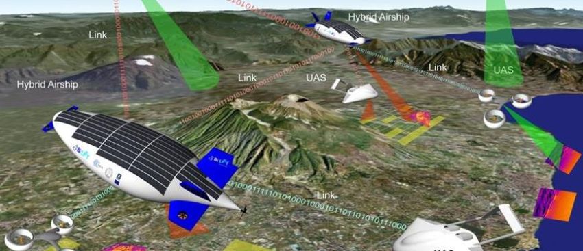
Futuro:
nuove
tecnologie e
nuove sfide
                                             Source: 17/1/2018 La Repubblica

               25/1/2018   Agenzia Spaziale Italiana – Applicazioni GNSS per la riduzione del rischio: opportunità e priorità   Pagina 2 / 19
Principali elementi del Trasporto Integrato (multi-modale),
                   servizi PVT associati e tipologia di rischio:

                                        Beni                                   Veicoli                             Infrastruttura

                               •   Logistica                         •   Localizzazione                       •   Progettazione
                               •   Localizzazione                    •   Navigazione                          •   Realizzazione
Il trasporto                   •   Tracciabilità                     •   Sincronizzazione                     •   Manutenzione
                               •   Dati                              •   Guida                                •   Monitoraggio
integrato:                                                           •   Automazione                          •   Controllo
elementi,                                                            •   Dati                                 •   Utilizzo ottimale
                                                                     •   Emergenze                            •   Dati
servizi e rischi                                                                                              •   Emergenze
                                                                         Comunicazione

                                           Rischio legato alla salvaguardia della vita delle persone
                                                                   (SAFETY)

                                    Rischio legato alla vulnerabilità dei dati, servizi e dell’infrastruttura
                                                      (SECURITY e CYBER-SECURITY)

                   25/1/2018           Agenzia Spaziale Italiana – Applicazioni GNSS per la riduzione del rischio: opportunità e priorità   Pagina 3/ 19
Le prestazioni «canoniche» del GNSS sono accuratezza, disponibilità,
continuità e integrità guidano la realizzazione di sistemi «safety»
La «security» si aggiunge per mitigare la vulnerabilità di tutto il sistema
Per i futuri servizi del trasporto integrato dobbiamo considerare la «liability»
come un terzo elemento vincolante
Le diverse
«prestazioni» Accuracy
della
funzione Integrity SAFETY Continuity
Position, Availability
Autenticazi
one
Velocity e Robustezza
ricevitore e
Monitoragg
io
Regolamen
LIABILITY
Time (PVT) Robustezza
terminale
Robustezza
prestazioni
Prestazioni
tazione
operazioni SECURITY minime,
Infrastrut-
e procedure certificazio
tura
ne
Robustezza
Segnali
25/1/2018 Agenzia Spaziale Italiana – Applicazioni GNSS per la riduzione del rischio: opportunità e priorità Pagina 4 / 19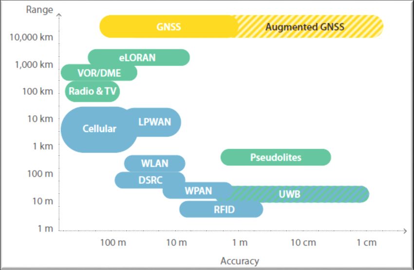
Per soddisfare le esigenze concorrenti della safety, security e liability è necessario
               assicurare un approccio multi-disciplinare che coniughi in modo ottimale la
               necessaria complessità tecnico-organizzativa con la fattibilità
               Diversi aspetti concorrono in questo complesso «puzzle» e relativi «tradeoff»

                                                             Standards

                                         Sensibilità                              Latenza
                                          a scenari                                                                    Manutenzi
                                                                                 (RT, NRT,
                                                                                                                         one e
Le                     Mono o
                                             non
                                          ottimali
                                                                                  Offline)
                                                                                                                       evoluzione

                                                                                                    Coerenza
prestazioni              multi
                      frequenza
                                                             Multipath
                                                                                                      dati
                                                                                                                                             Enti
                                                                                                                                         certificatori

della                                    Interferenze
                                             radio,
                                           jamming,
                                                                                 SAFETY                                Connettività
                                                                                                                        continua
                                            spoofing
funzione PVT          Indoor                                 SECURITY                               PVT data
                                                                                                                                            Altri?
                     Navigation                                                                      fusion
                                                                                                                        Sensori
                                           Mono o                                                                        diversi
                                            multi-                               LIABILITY
                                         costellazione
                                                                                                                       PVT e anti-
                                                             Autentica-                                                collosione
                                                               zione                                   Costi
                           Altri?                              (anti –                              realizzativi
                                                             falsificazio                           e operativi
                                         Mmonitorag-          ne PVT)           Peso, size,
                                                                                                                       Autonomia
                                            gio                                   power
                                                                                                                       e controllo
                                         prestazioni                            Ricevitore
                                                                                                                         remoto
                                           GNSS                                   GNSS

               25/1/2018            Agenzia Spaziale Italiana – Applicazioni GNSS per la riduzione del rischio: opportunità e priorità                   Pagina 5/ 19
The availability of state-of-art space infrastructure like Galileo and
EGNOS is a unique opportunity to develop the downstream market for
demanding applications and services
The GNSS downstream can now benefitting from:
The GNSS System of Systems (huge availability of signals, frequencies,
redundancy, interoperability, multi-constellation receivers)
The specific innovative features offered by Galileo and EGNOS with
EGNSS: different focuses on “safety”, “security” and “liability”
Dedicated Galileo/EGNOS User Support Facilities (GSC, GRC, ASQF,
paradigm PACF)
shift from Specific R&D and initiatives to support and accelerate the market uptake
Technologies The new “PVT service” paradigm offers different opportunities and
features to be customized for each market sector and type of
to Service applications, for example:
Mass market (miniaturization, low cost, maximum interoperability and
common standards)
Professional surveyor market (maximise accuracy, services “a la carte”)
Safety related applications (integrity first, certification, standards)
Security related (robustness and continuity first)
Demanding high performance applications (reliable, traceable,
predictable)
25/1/2018 Agenzia Spaziale Italiana – Applicazioni GNSS per la riduzione del rischio: opportunità e priorità Pagina 6/ 19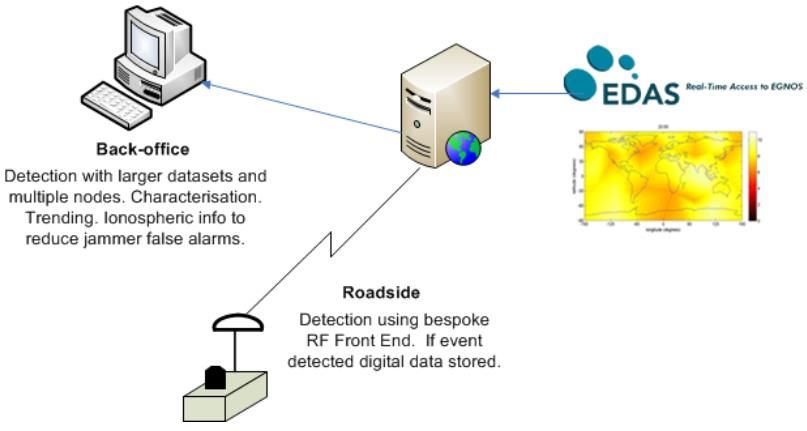
E-GNSS plays a role on the future demanding scenario of secure and efficient
                    transport sector:
                    1.        Galileo Signal Authentication (for both Open Service and for Commercial
                              Service) to be used for regulated and contractually binding applications
                    2.        Galileo Commercial Service High Accuracy for the most demanding
                              applications on decimeter level accuracy
                    3.        True interoperability of Galileo with GPS thanks to the GPS-Galileo time
                              offset transmitted on the SIS
E-GNSS              4.        The Galileo signals design facilitates the multipath detection and
is a plus                     integration with indoor navigation at receiver level
(even evolving)     5.        Galileo Public Regulated Services including additional “light PRS”
                              solutions under definition (light PRS receiver, without PRS key, using a
                              service center capable to process raw data and return secure and robust
                              PVT to user)
                    6.        Next generation EGNOS V3 (augmentation of GPS III and Galileo) for
                              safety and integrity
                    7.        Second Generation of Galileo (G2G) introducing new features to satisfy
                              the continuous evolution of needs of our society

                  25/1/2018        Agenzia Spaziale Italiana – Applicazioni GNSS per la riduzione del rischio: opportunità e priorità   Pagina 7/ 19
The tradeoff between “Accuracy and Range”:
               The different technologies and services

GNSS
Accuracy:
continuous
improvements

                                                                                                        Source: GSA User Technology Report

               25/1/2018   Agenzia Spaziale Italiana – Applicazioni GNSS per la riduzione del rischio: opportunità e priorità        Pagina 8/ 19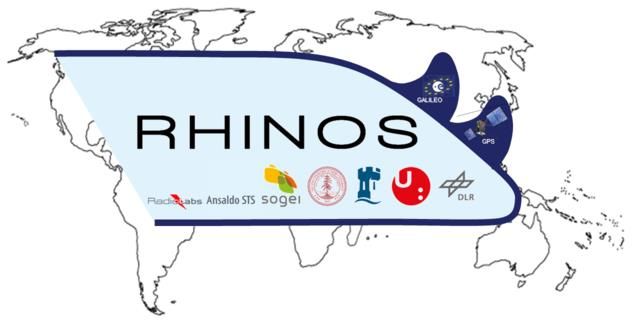
The tradeoff between “Accuracy and Range”:
               The different services and options to increase the accuracy

                                 Range /
                                 Coverage                                                                Galileo CS HA            Standalone Rx

                                         global

                                                                                                    PPP
PVT                                                                                                                      SBAS

performance
                                                                                                                              Integrity
                                       regional                                                                                 TTA

                                                                                            OmniSTAR

improvements                                                                                                             D-GNSS
                                           local
                                                                                                                             Code phase /
                                                                                                                             pseudorange
                                                                                          N-RTK

                                                                                                      Carrier Phase
                                                                                RTK                 No master station                               Horizontal
                                    very local                                                                                                       Accuracy
                                                                              Carrier Phase
                                                                        Requires 1 master station
                                                                                                                                                      (95%)

                                                                    1 cm                      10 cm                     1m                   10 m

               25/1/2018   Agenzia Spaziale Italiana – Applicazioni GNSS per la riduzione del rischio: opportunità e priorità                            Pagina 9/ 19
The future integrated transport services must be developed with a
                 multidisciplinary effort addressing different technology (not only GNSS)
                 and complementary non-space services and non-technical key enablers:
                 1.         Hybridization is a must, does not exist a single technology to answer
                            to all the requirements for a PVT function
                 2.         Additional non-space infrastructures must be designed and
                            developed to complement and improve the on-board PVT function
                            (e.g. ground infrastructures for assistance on road-side)
Opportunities    3.         Monitoring of the GNSS performances and associated vulnerabilities
                            must be available on permanent basis including characterization of
and needs                   them within specific critical areas
                 4. High accuracy maps and GIS are necessary at least the same level of
                    the adopted PVT capabilities (accuracy, integrity, reliability, certified by
                    mandated entities, updated when needed)
                 5.         Continuous and reliable connectivity to mobile users and vehicles is a
                            must (to enable added value service provision)
                 6. Definition of GNSS specific certification frames for the different
                    GNSS uses on transport domain (enable measurable and trustable
                    GNSS services)

                25/1/2018        Agenzia Spaziale Italiana – Applicazioni GNSS per la riduzione del rischio: opportunità e priorità   Pagina 10/ 19
The future integrated transport services development requires many
non –technical activities to be activated in parallel to the
technological innovation. We have to identify applications where it is
beneficial and necessary to introduce:
1. Certification (service providers and/or system design),
2. Minimum performance requirement, Standards, Type approval
(terminals, receivers, software, data),
Opportuniti
3. Regulations (EU and/or national level),
es and
4. Service Provision scheme including KPI’s (enabling service
needs provision and liability/insurance schemes)
5. Operational procedures (especially when more service providers
are contributing to the final PVT performances)
6. Business model (sustainability, private and public roles)
25/1/2018 Agenzia Spaziale Italiana – Applicazioni GNSS per la riduzione del rischio: opportunità e priorità Pagina 11/ 19 Project: InDrive
Objectives: develop and demonstrate an innovative but close-to-
market solutions for semi-automatic driving that heavily relying on
accurate and high-integrity satellite navigation
leverage EGNSS localization for automated manoeuvres in
automotive applications. In order to meet the requirements for each
of these use cases we will introduce a technology for innovative
confidence computation
Link: http://indrive-project.eu/
Esempi di
progetti
dimostrativi
Yellow area:
Warning
Red area:
Safety critical
25/1/2018 Agenzia Spaziale Italiana – Applicazioni GNSS per la riduzione del rischio: opportunità e priorità Pagina 12/ 19 Project: FOSTER ITS (First Operational, Secured and Trusted galilEo
Receiver )
Objectives: design and develop the first secured GNSS module available on
the market for ITS application. The FOSTER ITS products will be Galileo,
EGNOS, GPS and GLONASS enabled and will offer greater resilience against
the increasing range of GNSS threats by:
• Detecting signal attack attempts (spoofing, meaconing and jamming)
• Providing indicators to users about confidence of the positioning
Esempi di • Providing proof of the integrity and origin of the PVT (digital signature).
progetti Link: https://www.gsa.europa.eu/first-operational-secured-and-trusted-
galileo-receiver-its
dimostrativi
25/1/2018 Agenzia Spaziale Italiana – Applicazioni GNSS per la riduzione del rischio: opportunità e priorità Pagina 13/ 19 Project: ERSEC (Enhanced Road Safety by integrating Egnos-Galileo data
with on-board Control system)
Objectives: achieving a significant improvement in the vehicle positioning
accuracy, going from metres offered by the EGNOS/GNSS to decimetres with
an updating frequency of 100 Hz, to be primarily applied for significant
enhancing performance and level of confidence of collision avoidance
systems.
the system will be able to output the position on the road map of the equipped
vehicle and of all the obstacles (such as other vehicles, peoples and any kind of
fixed or mobile objects) around it with a measurement accuracy of the order of
Esempi di 0.1 metre at a sampling rate of 100 Hz through an intelligent datafusion of
the EGNOS/GNSS data - correlated to the Road-GIS digital local map - with the
progetti measurement data obtained from an instrument set installed on board of the
vehicle, including vehicle dynamic sensors (tachometer and gyro) and
dimostrativi environmental sensors (scanlasers).
Link: http://www.ersecproject.eu/
25/1/2018 Agenzia Spaziale Italiana – Applicazioni GNSS per la riduzione del rischio: opportunità e priorità Pagina 14/ 19 Project: DETECTOR (Detection, Evaluation and Characterization of
Threats to Road Applications)
Objectives: developed a low-cost GNSS radio frequency interference detection
service for use within road transport and critical applications. Roadside probes
connected to a back-office detect and characterise interference using
techniques which are made possible using software receivers
Link: http://www.gnss-detector.eu/
Esempi di
progetti
dimostrativi
Applications having requirement for interference detection based
on their reliance on GNSS to provide a critical element of their
solution:
• Road User Charging
• Pay-as-you Drive Insurance
• Fleet Management
• Hazardous Goods Tracking
• ADAS (& related safety, including cooperative systems)
• Stolen Vehicle Recovery
25/1/2018 Agenzia Spaziale Italiana – Applicazioni GNSS per la riduzione del rischio: opportunità e priorità Pagina 15/ 19 Project: STARS
Objectives: fill the gap between ERTMS needs for safety critical applications
and EGNSS services, through a characterisation of the railway environment.
Field measurement campaign to collect GNSS data, which is then being
analysed to identify and quantify possible local effects which have an
influence on GNSS performance, such as:
Multipath signal propagation
Electromagnetic Interference
Reduced satellite visibility
Esempi di
Link: http://www.stars-rail.eu/
progetti
dimostrativi
25/1/2018 Agenzia Spaziale Italiana – Applicazioni GNSS per la riduzione del rischio: opportunità e priorità Pagina 16/ 19 Project: RHINOS (Railway High Integrity Navigation Overlay System)
Objectives: increasing the use of EGNSS to support the safety-critical train
localization function for train control in emerging regional and global markets.
RHINOS adds value to EGNSS by leveraging the results from prior or existing.
The EGNSS (GPS and GALILEO) plus the SBAS constitute the reference
infrastructure that is available worldwide. In addition to that, local augmentation
elements, ARAIM techniques and other sensors on the train are the add-on
specific assets for mitigating the hazards due to the environmental effects which
dominates the rail application
Esempi di Link: http://www.rhinos-h2020.org/
progetti
dimostrativi
25/1/2018 Agenzia Spaziale Italiana – Applicazioni GNSS per la riduzione del rischio: opportunità e priorità Pagina 17/ 19 The road/rail transport infrastructures can use Space Assets to improve
efficiency and security with cost saving innovative applications based on
EGNOS/Galileo, Satellite remote sensing and telecommunication
The transport infrastructure stakeholders are expected to play an active and
key role on the development of the future mobility in term of investments
and technical/regulatory contribution
The future scenario is based on a interoperable set of services to be
integrated at infrastructure and mobile terminal levels (offering PVT,
connectivity, remote sensing data/services):
Conclusions
algorithms and for PVT services
Satellite Global Services (GNSS, EO, SATCOM)
Global
data fusion, «slicing»
High Altitude Pseudo-satellite Regional Services filtering, analytics, for heterogeneous
processing Service
UAV based local Services and prediction (different KPI,
Mobile terminal based cooperative Services quality, performances,
Security, safety,
Local
In-situ infrastructure based Services liability)
25/1/2018 Agenzia Spaziale Italiana – Applicazioni GNSS per la riduzione del rischio: opportunità e priorità Pagina 18/ 19 Italian Space Agency is engaged on the Space Economy and Technology Transfer (space-
to-ground and ground-to-space)
ESA and EC/GSA R&D programmes are fully supported and co-funded with a special
focus on pre-commercial project with high TRL and integrated space assets
ASI is also supporting long term objectives financing low TRL technology developments
for priority and critical elements
Recent technical developments have shown advantages in implementing synergies
between road and rail sectors for the hybridization and data fusion for secure and safety
PVT applications
Safety, security and liability have to be addressed together on the basis of tradeoff
between performances and feasibility
Conclusions Avoid to overcharge a single system or technology with all the performance
requirements, hybridization and diversification is a key
The future applications must be developed with the involvement of the whole value
chain for each key sectors and integrating Space and non-Space for different aspects:
Technology (sensors, platforms)
Software (algorithms)
Data (processing, analytics, sharing)
Added Value Services
Competences and knowhow
Standards, certification frames
Operational procedures for service provision
Risk assessment
Sustainability and flexibility
25/1/2018 Agenzia Spaziale Italiana – Applicazioni GNSS per la riduzione del rischio: opportunità e priorità Pagina 19/ 19Puoi anche leggere