LAYMAN'S REPORT LIFE08/NAT/IT/342 DEMETRA - DEvelopment of a quick Monitoring index as a tool to assess Environmental impacts of TRAnsgenic crops
←
→
Trascrizione del contenuto della pagina
Se il tuo browser non visualizza correttamente la pagina, ti preghiamo di leggere il contenuto della pagina quaggiù
Regione Toscana

     LAYMAN’S REPORT
LIFE08/NAT/IT/342 DEMETRA
  DEvelopment of a quick Monitoring index as a tool to assess
         Environmental impacts of TRAnsgenic crops

                                                                1
Indice - Index
    Beneficiary’s name
    Plant Genetics Institute, UOS Firenze, CNR (Coordinator)
    Dipartimento di Gestione dei Sistemi Agrari, Alimentari e Forestali (GESAAF),
    University of Florence
    Ente Parco Regionale Migliarino San Rossore Massaciuccoli
    Regione Toscana
                                                                                         5   Contenuti del progetto - Project Content
    Contributors
                                                                                         6   Obiettivi del progetto - Project Objectives
    CNR – IGV: Cristina Vettori, Anna Buonamici, Francesca Donnarumma, Elena
    Balducci, Filippo Cimò, Cesarea Caroppo, Giuliana Senatore, Catia Boggi,
                                                                                         8   Aree del progetto - Project Areas
    Simonetta Bianchi, sandro Capaccioli, Giovanni Giuseppe Vendramin, Valeria
    Tomaselli, Giuseppe Veronico, Giambattista Polignano, Pasquale Cataldo, Gio-
                                                                                        12   Attività e risultati del progetto - Activities and achievements of the projects
    acchino Carella, Domenico Pignone, Enrico Casalone (BIO – UNIFI), Francesco
    Vitali (BIO – UNIFI), Cristina Indorato (BIO – UNIFI), Donatella Paffetti (DISPAA
                                                                                        22   Continuazione e contesto - Project follow-up and
    – UNIFI), Maria Celeste Labriola (DISPAA – UNIFI) e Stefano Biricolti (DISPAA –          socio-economico del progetto - socio-economic context of the project
    UNIFI)
    CNR – ISE: Lorenzo Chelazzi, Isabella Colombini
    CNR – IBIMET: Alessandro Materassi e Gianni Fasano
    GESAAF – UNIFI: Davide Travaglini, Susanna Nocentini, Francesca Bottalico,
    Silvia Fiorentini, Chiara Lisa
    ENTE PARCO REGIONALE MIGLIARINO SAN ROSSORE MASSACIUCCOLI: Anto-
    nio Perfetti, Olga Mastroianni
    REGIONE TOSCANA: Laura Bartalucci, Carlo Chiostri, Roberto Pagni, Carla
    Lazzarotto, Fabio Boscaleri, Alvaro Fruttuosi, Marco Sulas, Simonetta Demuro,
    Rossana Nencioni, Marisa Nigro, Riccardo Russu, Barbara Camboni

    Project duration
    01/01/2010 - 30/06/2013

    Total cost and EU contribution
    Total project budget: 1.822.590 €
    European Commission contribution: 897.834 €

    Project’s contact details
    Coordinator and scientific responsible of the project
    Cristina Vettori – CNR-IGV
    Madonna del Piano 10 -
    50019 Sesto Fiorentino
    Firenze (Italia)
    Uff. +39 055 5225728
    Fax +39 055 5225729
    cristina.vettori@cnr.it

    Project Manager
    Laura Bartalucci – Regione Toscana
    Via di Novoli, 26
    50127 – Firenze (Italia)
    Uff. +39 055 4385268
    Fax +39 055 4383134
    laura.bartalucci@regione.toscana.it

    Technical coordination
    Communication Manager
    Alvaro Fruttuosi - Regione Toscana

    Communication staff
    Marco Sulas - Regione Toscana
    Simonetta Demuro - Regione Toscana

    Website
    www.life-demetra.eu

    Realizzazione: centro stampa Giunta Regione Toscana

                 Regione Toscana

2                                                                                                                                                                              3
CONTENUTI DEL PROGETTO - CONTENT OF THE PROJECT
    Nel 2008 il programma comunitario LIFE+ ha               In 2008 the Community program LIFE + gave
    dato l’opportunità di presentare dei progetti per        the opportunity to present projects to develop
    sviluppare e approfondire il tema della valutazio-       and deepen the theme of the environmental risk
    ne del rischio ambientale degli Organismi Geneti-        assessment of Genetically Modified Organisms
    camente Modificati (OGM), attraverso lo sviluppo         (GMOs), through the development of specific
    di specifici sistemi di monitoraggio ambientale.         environmental monitoring systems. At that time
    In quel periodo l’Italia stava delineando un qua-        Italy was outlining a legislative framework which
    dro legislativo che suggeriva il bisogno di defini-      suggested the need to define the rules of coex-
    re regole di coesistenza per adempiere ai vincoli        istence to fulfill its obligations under Community
    della legge comunitaria e osservare quanto pre-          law and comply with the national legislation in
    visto dalla legislazione nazionale in vigore (L. n.      force (Law n.5/2005). In this regulatory frame-
    5/2005). In questo quadro normativo, la Regione          work, the Tuscany Region promoted the idea of
    Toscana promosse l’idea di sviluppare un proget-         developing a LIFE + project on the theme of the
    to LIFE+ sul tema del monitoraggio ambientale            monitoring of GMOs, to try to fill the gap related
    degli OGM, per riempire il vuoto connesso alla           to the lack of standardized tools to carry out envi-
    mancanza di strumenti standardizzati per portare         ronmental monitoring of GMOs and, at the same
    avanti tale monitoraggio e, allo stesso tempo, ri-       time, respond to the need to protect its territory
    spondere al bisogno di proteggere il territorio dai      from risks determined by transgenic crops.
    rischi connessi con le colture transgeniche.             The DEMETRA project contributes to building a
    Il progetto promosso dalla Regione Toscana, de-          shared basis at Community level for the monitor-
    nominato DEMETRA (DEvelopment of a quick Mo-             ing of GMOs into the environment, whether they
    nitoring index as a tool to assess Environmental         are directly cultivated for commercial purposes,
    impacts of TRAnsgenic crops), contribuisce a co-         whether they are used in a given place for re-
    struire una base condivisa sul piano comunitario         search purposes.
    per il monitoraggio degli OGM nell’ambiente, sia         The main objective of the Project was the crea-
    che essi siano coltivati per scopi commerciali           tion of an innovative instrument to rapidly ad-
    che per scopi di ricerca.                                dress monitoring efforts that Public Bodies
    L’obiettivo principale del progetto era la creazio-      should implement in their territories when trans-
    ne di uno strumento innovativo per implementare          genic crops are cropped. Particularly on when,
    i sistemi di monitoraggio che gli Enti pubblici de-      where and how the data collection should be
    vono adottare nei territori destinati a coltivazioni     switched on.
    transgeniche. In particolare, i risultati del progetto
    aiuteranno gli Enti preposti a stabilire quando, dove
    e come eseguire la raccolta di dati di monitoraggio.

4                                                                                                               5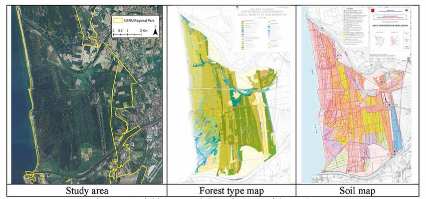
Gli ecosistemi presi in esame dal progetto DEMETRA com-            To do this forest, wetland and agricultural areas were
                OBIETTIVI DEL PROGETTO - PROJECT OBJECTIVES                                                                             prendono le foreste, gli ambienti umidi, le aree agricole ed       selected. In each study area the following data were as-
                                                                                                                                        incolti. In ciascun ecosistema sono stati rilevati e analizzati    sessed:
L’obiettivo principale del progetto DEMETRA è definire un          The main objective of the DEMETRA project is to define an            i seguenti dati:                                                   a) meteorological conditions (rainfall, air temperature and
metodo innovativo per valutare il rischio ambientale causa-        innovative method to assess the environmental risk caused            a) condizioni meteorologiche (piovosità, temperatura e umi-           humidity, wind speed and direction, diffused and global
to dalla presenza di colture geneticamente modificate e de-        by the presence of genetically modified crops and to define              dità dell’aria, velocità e direzione del vento, radiazione        radiation, sunshine duration). To this aim three weather
finire un indice sintetico di monitoraggio, il Quick Monitor In-   a synthetic index of monitoring, the Quick Monitor Index                 diffusa e globale, eliofania) attraverso l’installazione di       stations were placed;
dex (QMI), che evidenzi le aree e gli indicatori da prendere in    (QMI) that highlights the areas and indicators that might be             tre stazioni meteorologiche;                                   b) biodiversity through the quantification of microbial, plant
considerazione per le azioni di monitoraggio. Le attività del      taken into consideration for monitoring actions.                     b) biodiversità attraverso la quantificazione di specie mi-           and animal species and through the study of trophic
progetto non hanno previsto l’uso di organismi transgenici,        The activities of the project have not involved the use of trans-        crobiche, vegetali e animali e lo studio delle relazioni          webs using stable isotope analysis (13C and 15N);
e la metodologia adottata si è basata su una dettagliata           genic organisms, because the methodology adopted is based                trofiche mediante analisi degli isotopi stabili (13C e 15N);   c) pollen flows of the study cropped species (maize, sun-
analisi degli ecosistemi su cui si è inserito lo studio di una     on detailed analysis of ecosystems and environmental resourc-        c) flusso di polline delle specie vegetali coinvolte nel pro-         flower, oilseed rape and poplar) with pollen samples
matrice di rischio collegata a piante transgeniche (esistenti      es on which is grafted the study of a matrix of risk related to          getto (mais, girasole, colza e pioppo) con campioni di            collected by pollinators and by pollen traps, and conse-
a livello internazionale), derivante da dati bibliografici e da    transgenic plants (existing at international level and potentially       polline raccolto da impollinatori e trappole polliniche,          quent laboratory analysis by molecular markers.
dati ecologico-biologici rilevati nel corso del progetto.          used in the studied area), derived from bibliographic data and           con conseguente analisi di laboratorio mediante marca-
                                                                   ecological/biological data derived from the project.                     tori molecolari.
Il progetto ha previsto la realizzazione delle seguenti azioni:
• Raccolta, analisi e selezione dei parametri che descri-          The project foresees the following overall actions:
    vono gli ambienti considerati in relazione alle condizio-      • Collecting, analysing and selecting already known pa-
    ni atmosferiche locali, alla funzionalità del terreno, alle       rameters linked to weather local conditions, soil func-
    catene trofiche, agli usi del territorio, alla biodiversità       tionality, trophic chains, landscape uses, biodiversity
    animale e vegetale;                                               and biodiversity loss to generate a model, which are the
• Valutazione dei dati raccolti e selezione di quelli più si-         basis for the generation of the quick monitoring index.
    gnificativi per sviluppare l’indice QMI;                       • Assessing the suitability of data collected with the most
• Sviluppo dell’indice QMI e analisi degli effetti potenziali         relevant monitoring programs and selecting the most rel-
    che le colture transgeniche possono apportare a un cer-           evant ones.
    to ecosistema o biotipo;                                       • Developing the index so to express the potential per-
• Identificazione di specifici siti di studio dove simulare           turbation that transgenic crops could pose to a certain
    l’applicazione del QMI;                                           ecosystem or biotope.
• Modellizzazione su base cartografica dell’indice QMI uti-        • Identifying and creating specific study sites to generate
    lizzando un Sistema Informativo Geografico (GIS).                 simulations of the application of the QMI.
• Sviluppo di linee guida e best practices per applicare gli       • Creating a GIS platform to run the modeling system.
    schemi di monitoraggio nelle aree a rischio OGM.               • Developing guidelines and best practices to apply moni-
                                                                      toring schemes in high risk areas.

6                                                                                                                                                                                                                                                                      7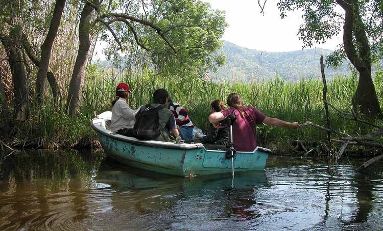
Il Lago di Massaciuccoli (insieme all’area circostante) co-       Massaciuccoli Lake and its surrounding marsh area is one of
                          AREE DEL PROGETTO - PROJECT AREAS                                                                            stituisce uno dei più importanti habitat di ambienti umidi in     the most important wetland habitats in Italy. It is character-
                                                                                                                                       Italia. Il lago è ampio e poco profondo, mediamente meno          ized by a large lake slightly deep, on average less than two
La raccolta dei dati è stata condotta nel Parco Regionale           Fieldworks were carried out in the Regional Park of Migli-         di due metri, con ovvi problemi di eutrofizzazione.               meters, with obvious problems of eutrophization and wide
di Migliarino - San Rossore - Massaciuccoli, in provincia di        arino – San Rossore – Massaciuccoli, in the province of            Gli habitat di interesse comunitario (Annex I Dir. 92/43          marsh areas, particularly in northern part of the site.
Pisa. L’area protetta è caratterizzata da un’ampia diversità        Pisa (central Italy). The protected area is characterized by a     CEE) sono: 3140 – “Acque oligomesotrofe calcaree con ve-          Habitats of community interest (according to the Annex I Dir.
di ecosistemi naturali e da un’alta presenza di terreni adatti      wide diversity of natural ecosystems and a high presence of        getazione bentica di Chara spp.”, 7150 – “Depressioni su          92/43) are: 3140 – “Hard oligo-mesotrophic waters with ben-
all’agricoltura. Il progetto si è concentrato su tre aree di stu-   lands suitable for agriculture. The project focused on three       substrati torbosi del Rhynchosporion” e l’habitat prioritario     thic vegetation of Chara spp.”, 7150 – “Depressions on peat
dio caratterizzate da differenti ecosistemi. In ciascuna area       study areas characterized by different ecosystems. In each         7210 – “Paludi calcaree con Cladium mariscus e specie del         substrates of the Rhynchosporion” and the priority habitat
di studio sono stati compiuti diversi tipi di analisi.              study area several types of analysis were performed.               Caricion davallianae”. Tra le specie vegetali Marsilea quadri-    7210 – “Calcareous fens with Cladium mariscus and species
                                                                                                                                       folia è inclusa nell’allegato II della Dir 92/43 CEE.             of the Caricion davallianae”. Among the plant species, Mar-
                                                                    STUDY AREA 1 (MASSACIUCCOLI LAKE)                                  Le specie animali sono molto più numerose. E’ un impor-           silea quadrifolia is included in the Annex II of the Dir 92/43.
AREA DI STUDIO 1 (LAGO DI MASSACIUCCOLI)                            The “Lago e Padule di Massaciuccoli” (Cod. Natura2000              tante sito per gli uccelli migratori e anche di svernamento.      The animal species are much more numerous. In addition,
                                                                    IT5120021) covers a total area of 1,908.01 ha, and it is a         Tra le specie più significative c’è certamente il tarabuso        it is an important site for migratory and wintering species of
Il “Lago e Padule di Massaciuccoli” (Cod. Natura2000                “Site of Community Importance” (SCI) according to the di-          (Botaurus stellaris), per il quale il lago è la più importante    birds. Among the breeding species of greatest importance
IT5120021) ricopre una superficie complessiva di 1.908,01           rective 92/43/CEE. Additionally, the SCI overlaps the “Site        area di nidificazione a livello nazionale; poi si sottolinea la   is certainly the bittern (Botaurus stellaris), for which the lake
ha ed è un Sito di Importanza Comunitaria (SIC) ai sensi            of Regional Importance” (SIR) according to the Regional            presenza di Ixobrychus minutus, Ardea purpurea, Himanto-          is the most important nesting area at national level; then,
della Direttiva 92/43/CEE. Inoltre, il SIC si aggiunge al Sito      Law L.R. 56/2000.                                                  pus himantopus, Circus aeroginosus e Acrocephalus melano-         we underline the presence of Ixobrychus minutus, Ardea
di Importanza Regionale (SIR) ai sensi della L.R. 56/2000.          This site is entirely included in the Regional Park of Miglia-     pogon. Tutte queste specie sono prevalentemente collegate         purpurea, Himantopus himantopus, Circus aeroginosus and
Il sito è completamente incluso nel Parco Regionale di Mi-          rino – San Rossore – Massaciuccoli and in the contiguous           alle aree paludose, in particolare i canneti.                     Acrocephalus melanopogon. All these species are related
gliarino - San Rossore - Massaciuccoli e nell’area contigua.        area. A protected area managed by LIPU (Italian League for         L’Amphibian Triturus carnifex, un endemismo italiano e il         mainly to the marsh areas and in particular reeds.
All’interno del sito è anche presente un’area protetta gestita      Protection of Birds) is inside the site here considered.           Reptile Emys orbicularis sono specie di interesse comunita-       The Amphibian Triturus carnifex, an italian endemism, and
dalla LIPU (Lega Italiana per la Protezione degli Uccelli).         The land of the project area is designed to agriculture and it     rio, menzionate nell’Annex II della Dir 92/43/CEE.                the Reptile Emys orbicularis are species of Community inter-
È uno specchio d’acqua dolce circondato da paludi, forma-           falls in a private property.                                                                                                         est, named in Annex II of Dir. 92/43/CEE
zioni eliofitiche (canneti e cladieti) e frammenti di vegetazio-    Lake of fresh water surrounded by elophytic formations (reeds
ne legnosa. L’area è caratterizzata anche da boschi. Inoltre        and spp. Cladium), bogs and upland vegetation. The area is
sono presenti numerose specie a rischio e annoverate nelle          also characterized by upland forests. It is characterized by nu-
liste rosse regionali e nazionali, tra cui Cladium mariscus e       merous threatened species, according to national and regional
altre specie rare, come la Periploca graeca (una delle poche        red lists, such as Cladium mariscus and other rare species,
stazioni italiane) e la Drosera rotundifolia, una specie parti-     such as Periploca graeca (one of the few Italian stations) and
colarmente rara nelle paludi.                                       Drosera rotundifolia, a very rare upland species in the bog.

8                                                                                                                                                                                                                                                                       9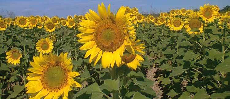
AREA DI STUDIO 2 (FIUME SERCHIO) E AREA DI                          STUDY AREA 2 (SERCHIO RIVER) AND STUDY AREA 3                     Altri habitat di interesse comunitario presenti nelle aree di       Other habitat types of UE interest are: 91E0 – “Alluvial for-
STUDIO 3 (FIUME ARNO)                                               (ARNO RIVER)                                                      studio sono, per quanto riguarda la vegetazione forestale:          ests with Alnus glutinosa and Fraxinus excelsior (Alno-Padi-
                                                                                                                                      91E0 – “Foreste alluvionali di Alnus glutinosa e Fraxinus           on, Alnion incanae, Salicion albae)”; 91F0 – “Riparian mixed
Queste aree di studio rientrano nel SIC/SIR/SPA “Selva Pi-          These study areas fall within the SCI/SIR/SPA “Selva              excelsior (Alno-Padion, Alnion incanae, Salicion albae)”; 91F0      forests of Quercus robur, Ulmus laevis and Ulmus minor,
sana” (Cod. Natura2000 IT5170002) e coprono complessi-              Pisana” (Cod. Natura2000 IT5170002) with a total area of          – “Foreste miste riparie di grandi fiumi a Quercus robur, Ul-       Fraxinus excelsior or Fraxinus angustifolia, along the great
vamente una superficie di 9.658,34 ha.                              9,658.34 ha.                                                      mus laevis e Ulmus minor, Fraxinus excelsior o Fraxinus an-         rivers (Ulmenion minoris)”; 92A0 – “Salix alba and Populus
Il sito è interamente incluso nel Parco Regionale di Migliari-      This site is entirely included in the Regional Park of Miglia-    gustifolia (Ulmenion minoris)”; 92A0 – “Foreste a galleria          alba galleries”; 9340 – “Quercus ilex and Quercus rotun-
no - San Rossore - Massaciuccoli.                                   rino – San Rossore – Massaciuccoli.                               di Salix alba e Populus alba”; 9340 – “Foreste di Quercus           difolia forests”; 2270 – “Wooded dunes with Pinus pinea
Le aree di studio del progetto ricadono nella proprietà pub-        The land of the project area falls in the public property of      ilex e Quercus rotundifolia”; 2270 – “Dune con foreste di           and/or Pinus pinaster”. As far as wetlands and wet mead-
blica della Regione Toscana e sono gestite dal Parco Regio-         the Region of Tuscany and it is managed by the Regional           Pinus pinea e/o Pinus pinaster”. Per quanto riguarda le aree        ows: 1150 – “Coastal lagoons”; 1410 – “Mediterranean
nale di Migliarino - San Rossore - Massaciuccoli.                   Park of Migliarino – San Rossore – Massaciuccoli.                 umide: 1150 – “Lagune costiere”; 1410 – “Pascoli inondati           salt meadows (Juncetalia maritimi); 1420 – “Mediterranean
                                                                    It is a sandy coast, mostly in regression, characterized by       mediterranei (Juncetalia maritimi); 1420 – “Praterie e fru-         and thermo-Atlantic halophilous scrubs (Sarcocornietea fru-
La zona litoranea è caratterizzata da una costa sabbiosa,           the typical sequence of plant formations of sand heaths           ticeti alofili mediterranei e termo-atlantici (Sarcocornietea       ticosi); 1510 - Mediterranean salt steppes (Limonietalia);
prevalentemente in regressione, composta dalla tipica se-           (Cakile maritima community, Elymus farctus community, Am-         fruticosi); 1510 - Steppe salate mediterranee (Limonietalia);       ; 6420 – “Mediterranean tall humid herb grasslands of
rie di vegetazione dunale con cakileto, agropireto, ammofi-         mophyila littoralis community, Helichrysum stoechascom-           6420 – “Praterie umide mediterranee con piante erbacee              theMolinio-Holoschoenion”.
leto, elicriseto e ginepreto (Cakile maritima, Elymus farctus,      munity and Juniperus oxycedrus ssp. macrocarpa commu-             alte del Molinio-Holoschoenion”.                                    The wetlands included in the area here considered, are in-
Ammophila littoralis, Helichrysum stoechas, Juniperus oxyce-        nity). In the inland, the area is characterized by an internal    Le paludi, incluse nell’area qui considerata, sono di interes-      teresting at National and sometimes at International level,
drus ssp. macrocarpa). Nelle zone più interne la tipologia          system of fossil dunes and interdunes with alternance of          se nazionale e talvolta anche internazionale, per lo sverna-        for the wintering of waterfowl and for the rest during migra-
ambientale prevalente è quella di un sistema di dune e in-          pine forests with Pinus pinaster or Pinus pinea, high bush,       mento di uccelli acquatici e per la sosta durante la migra-         tion along the Tyrrhenian coast route.
terdune fossili con alternanza di pinete di pino marittimo,         freshwater and brackish wetlands, wet forests with ash and        zione lungo la costa tirrenica.                                     Dunal and retrodunal habitat host rare species of plants,
pino domestico e lecci, macchia alta, aree umide salmastre          alder. The inland wetlands and salt marshes are charac-           L’habitat dunale e retrodunale ospita specie vegetali rare,         such as Solidago virgaurea L. spp. litoralis (Savi)Burnat (an
e dolci, vasti boschi mesofili a farnia e boschi igrofili con on-   terized by a mosaic of halophilous shrub communities and          come la Solidago virgaurea L. spp. litoralis (Savi)Burnat (un       endemism of versiliese-pisano sandy coast), Stachys recta
tano e frassino. Le aree umide interne si caratterizzano per        helophytic plant formations, such as Phragmites australis         endemismo della costa sabbiosa versiliese-pisana), Stachys          L. var. psammofila Fiori (endemism of the Tyrrhenian coast),
la presenza di mosaici di salicornieti, formazioni di eliofite      communities and Carex sp.pl. communities, and other wet           recta L. var. psammofila Fiori (endemismo della costa tirre-        Periploca graeca L. (one of the few Italian stations).
e prati umidi allagati nel periodo invernale. Gli ecosistemi        meadows flooded in winter.                                        nica), Periploca graeca L. (una delle poche stazioni italiane).     Several nesting populations of UE interest species (in par-
dunali e le aree umide retrodunali ospitano habitat e specie        Dunal ecosystems and humid retrodunal areas host habitats         Sono altresì presenti diverse popolazioni nidificatrici di specie   ticular Burhinus oedicnemus).
rare di flora ad alto interesse naturalistico.                      and species of flora and fauna with high conservatory interest.   di interesse comunitario (in particolare Burhinus oedicnemus).      Reproductive populations of Rhinolophus ferrumequinum
                                                                    One of the 2-3 best examples of dunal habitat in Tuscany,         Popolazioni riproduttive di Rhinolophus ferrumequinum e             and Myotis emarginatus, species inserted in the Annex II
In Toscana, uno tra i migliori esempi di habitat dunale lie-        slightly influenced by man, is included in the considered         Myotis emarginatus, specie inserite nell’Annex II della Diret-      of 92/43 EEC Directive, live in the considered area. Rhi-
vemente influenzato dall’uomo è incluso nell’area conside-          area. Dunal habitat of this area represent one of the best        tiva CEE 92/43, vivono nell’area considerata. La colonia di         nolophus ferrumequinum’ s colony is the only one known
rata che, insieme al vicino sito “Duna costiera di Torre del        ones along the Tyrrhenian coast and, together with the            Rhinolophus ferrumequinum è l’unica conosciuta in Toscana           in Tuscany and the biggest in Italy; some individuals of this
Lago”, è l’unico in buono stato di conservazione nel nord           neighbouring site “Coastal Dune of Torre del Lago”, the only      ed è la più grande in Italia; alcuni individui di questa colonia    colony winter in a building inside the site.
della Toscana. Queste considerazioni relative agli ambienti         one in a good state of conservation in the northern Tuscany.      svernano in un fabbricato presente all’interno del sito.
dunali riguardano habitat di interesse comunitario (ai sensi        These considerations are related to habitats of UE interest
della Dir 92/43 CEE), quali: 1210 – “Vegetazione annua              (according to the 92/43 EEC Directive), 1210 – “Annual
delle linee di deposito marine” (cakileto); 2110 – “Dune            vegetation of drift lines” (Cakile maritima comm.); 2110 –
embrionali mobili” (agropireto); 2120 – “Dune mobili del            “Embryonic shifting dunes” (Elymus farctus comm.); 2120
cordone litorale con presenza di Ammophila arenaria (dune           – “Shifting dunes along the shoreline with Ammophila arenar-
bianche)” (ammofileto); 2130 – “Dune costiere fisse a ve-           ia” (white dunes; Ammophila arenaria comm.); 2130 – “Fixed
getazione erbacea (dune grigie)” (elicriseto, habitat priorita-     coastal dunes with herbaceous vegetation (grey dunes)” (Heli-
rio); 2250 – “Dune costiere con Juniperus spp.” (ginepreto,         chrysum stoechas comm., priority habitat); 2250 – “Coastal
habitat prioritario).                                               dunes with Juniperus spp.” (priority habitat).

10                                                                                                                                                                                                                                                                  11
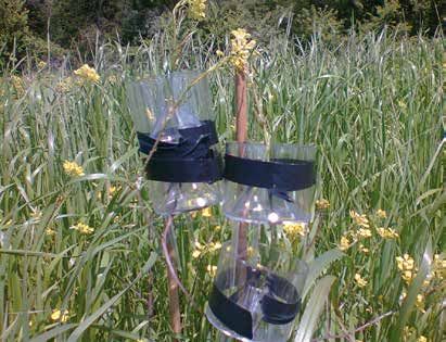
VALUTAZIONE DEL FLUSSO DI POLLINE                                  POLLEN FLOW EVALUATION
                     ATTIVITÀ E RISULTATI DEL PROGETTO                                                                                    Per studiare la dispersione pollinica delle specie coltivate       To study the pollen dispersion by wind of the cultivated
              ACTIVITIES AND ACHIEVEMENTS OF THE PROJECTS                                                                                 (mais, girasole, colza e pioppo) dovuta al trasporto del ven-
                                                                                                                                          to sono state installate delle trappole polliniche intorno alle
                                                                                                                                                                                                             species (maize, sunflower, oilseed rape and poplar) pollen
                                                                                                                                                                                                             traps were installed in strategic positions around marked
ORGANIZZAZIONE E RACCOLTA DELLA DOCUMENTAZIONE                       ORGANIZATION AND COLLECTION OF DOCUMENTATION                         colture a diverse distanze.                                        crops (maize, sunflower, oilseed rape) and the poplar plan-
E’ stata raccolta tutta la documentazione tecnica, scienti-          All relevant technical, scientific and legislative documenta-        È stato così determinato il trend della concentrazione di          tation. The trend of pollen concentration in relation to dis-
fica e legislativa. Un database con i risultati della raccolta       tions were collected. A database of the current bibliographical      polline in funzione della distanza dalle specie coltivate. Il      tances in meter was determined. In each cultivation, maize
bibliografica è disponibile per la consultazione sul sito del        collection containing the scientific literature, created external-   polline di mais è stato trovato fino ad una distanza di 300        pollen was found at a distance of 300 m, oilseed rape at
progetto (http://www.life-demetra.eu). Questa raccolta è             ly to the project, and collected during the activity, is available   m, quello di colza fino a 34 m, quello di girasole fino a 19 m     34 m, sunflower at 19 m, and poplar at 540 m. Focusing
stata costantemente aggiornata.                                      in the website of the project (http://www.life-demetra.eu).          e quello di pioppo fino a 540 m.                                   on the concentration of pollen we found that poplar pollen
                                                                     This collection was kept updated during project duration.            Sulla base dei dati raccolti è stato osservato che la concen-      concentration remained constant to 540 m; oilseed rape
AREA COLTIVATA                                                                                                                            trazione di polline del pioppo rimaneva costante fino a 540        pollen decreased after 3 m then it was constant and then
Diverse varietà di mais, girasole e colza sono state coltivate       CROPPED AREA                                                         m di distanza dalle pioppete coltivate; la concentrazione del      decreased again at 30 m; sunflower pollen concentration
nell’Area della “Culatta” (Area di Studio 3). Le coltivazioni        Different varieties of maize, sunflower and oilseed rape             polline di colza diminuiva entro i primi 3 m per poi rimanere      remained constant to 5 m, then drastically decreased and
sono state ripetute per tre anni consecutivi in modo da ot-          were cropped in the Area “Culatta” (Area 3). Cultivations            costante e diminuire nuovamente a 30 m di distanza dalle           arrived at zero after 19 m; maize pollen tend to zero at dif-
tenere informazioni su:                                              were repeated for three consequent years so as to obtain             coltivazioni; la concentrazione del polline di girasole rima-      ferent distances, after 300 m it is not found.
• Dispersione del polline delle diverse specie,                      information on:                                                      neva costante nei primi 5 m per poi diminuire drasticamen-         To study the pollen flow by insect pollinator:
• Biodiversità in associazione alle colture,                         • pollen dispersal of the different species,                         te ed arrivare a zero dopo i 19 metri dalle coltivazioni; la       - eight bee hives were installed at different distances (1
• Percorsi trofici a livello ecosistemico.                           • the biodiversity in association to the crops;                      concentrazione di polline di mais tendeva a zero a diverse             km, 2 km, 3 km) from the experimental field of sunflower
                                                                     • the trophic pathways at ecosystem level.                           distanze, ma non ve n’era più traccia dopo 300 m.                      to study pollen flow by Apis mellifera.
DATI METEOROLOGICI                                                                                                                        Per studiare il flusso pollinico dovuto agli impollinatori si è    - forty insect traps were installed around the field of maize
È stata installata una stazione meteorologica in ciascuna            METEOROLOGICAL PHYSICAL DATA                                         così proceduto:                                                        and sunflower at increased distance from the border of
area di studio per raccogliere i dati relativi a temperatura e       Meteorological stations were set in three sites within three         - Otto alveari sono stati installati a diverse distanze (1 km,         the cultivations up to a distance of 3 km to study pollen
umidità dell’aria, piovosità, velocità e direzione del vento.        test area (cropped site, non cultivated site, Massaciuccoli              2 km, 3 km) dal campo sperimentale di girasole per stu-            flow by pollinator Hymenoptera.
Inoltre sono state misurate l’umidità e la temperatura del           Lake), to collect data related to air humidity, air tempera-             diare il trasporto di polline da parte dell’Apis mellifera.
suolo e i flussi radiativi solari (globale, diffuso, ultravioletto   ture, rainfall and wind speed and direction. Additionally,           - 40 trappole sono state installate intorno ai campi di mais
A e B, eliofania).                                                   measures were taken to determine: soil moisture and soil                 e girasole a distanze crescenti dal bordo delle coltivazioni
Per ottenere dati non influenzati dalla presenza di vegetazio-       temperature, solar radiative fluxes (global, diffuse, ultravio-          fino a una distanza di 3 km per studiare il trasporto di
ne erbacea e/o arborea in prossimità delle stazioni meteo, i         let A and B, and sunshine duration).                                     polline effettuato dall’impollinatore Hymenoptera.
parametri meteorologici (fatta eccezione per i flussi radiativi      In order to obtain data not influenced by the type of vegetation     -
solari) sono stati misurati in una zona aperta del campo a           (grass or trees), in cropped and non cultivated sites mete-
2,5 m di altezza, mentre velocità e direzione del vento sono         orological parameters (except for solar radiation fluxes) were
stati registrati a 5 e a 10 m di altezza. Tutti i parametri sono     measured in an “open” zone of the field at 2.5 m of height,
stati registrati ogni 3 minuti, mentre le medie sono state           while wind speed and direction were registered at 5 and 10 m
calcolate e registrate ogni 15 minuti.                               of height. All parameters were recorded every 3 minutes and
I bollettini meteorologici annuali sono disponibili sul sito del     averages were performed and memorized every 15 minutes.
progetto e continueranno a essere registrati anche dopo la           Annual meteorological bulletin are available in the website
conclusione dello stesso.                                            of the project and will be continued to be registered also
                                                                     after its conclusion.

12                                                                                                                                                                                                                                                                     13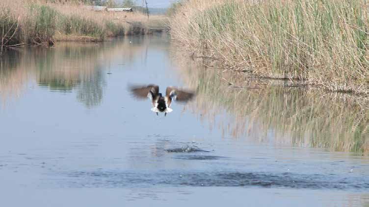
VALUTAZIONE DELLA BIODIVERSITÀ LOCALE                                 ASSESSMENT OF LOCAL BIODIVERSITY                                   • Vegetazione boschiva. La maggior parte dei boschi me-          • Woody vegetation. Most of the meso-hygrophilous for-
1) Diversità vegetale (erbe e legnose)                                1) Plant Diversity (weeds and trees)                                 so-igrofili in San Rossore sono rappresentati dall’associa-      est in S. Rossore are represented by the association
Attraverso la raccolta e la classificazione di campioni rac-          Through the collection and classification of plant samples           zione Fraxino angustifoliae-Quercetum roboris Gellini, Pe-       Fraxino angustifoliae-Quercetum roboris Gellini, Pedrotti,
colti nei diversi siti di studio, sono stati identificati e censiti   taken in the different study sites, 307 plant taxa were iden-        drotti, Venanzoni 1986. In alcune aree, caratterizzate da        Venanzoni 1986. In some areas, characterized by long
307 taxa vegetali. Alcuni di essi sono specie a rischio, o            tified. Some of them are threatened species, or have high            lunghe inondazioni, è stata trovata una variante di pioppo       water flooding, a variant with Populus alba L. was found
sono ad alto interesse conservativo, in accordo con le liste          conservation interest, as belonging to national and regional         chiamata Populus alba L. (Tomei et al., 2004). Nel sito          (Tomei et al., 2004). In the “Culatta” site (Area 3), along
rosse nazionali e regionali, quelle del CITES o dell’allegato         red lists, or to the CITES lists or to the Annex II of the Habi-     della “Culatta” (Area 3), lungo la costa, sono molto diffusi     the coast, Pinus pinea L. woods are widespread. The her-
II della Direttiva Habitat (CEE 92/43).                               tat Directive (92/43 EEC Directive).                                 impianti a Pinus pinea L.. Qui lo strato erbaceo è carat-        baceous layer is characterized by several species, main-
Molte di queste ricadono nell’area del Lago di Massaciuc-             Most of them fall within the area of the Massaciuccoli Lake:         terizzato da diverse specie, soprattutto Gramineae (Bra-         ly Gramineae (Brachypodium sylvaticum (Huds.) Beauv.,
coli: Periploca graeca L. e Hibiscus palustris L. [vulnerabile        Periploca graeca L. and Hibiscus palustris L. [vulnerable (VU)       chypodium sylvaticum (Huds.) Beauv., Dactylis glomerata          Dactylis glomerata L., Agropyron repens (L.) Beauv.).
(VU) a livello nazionale]; Hydrocotyle vulgaris L. [a rischio         at national level]; Hydrocotyle vulgaris L. [endangered (EN)         L., Agropyron repens (L.) Beauv.). Il bosco naturale con         The natural wood with poplar in area Serchio (Area 2)
(EN) a livello nazionale] e Anagallis tenella (L.) L. [gravemen-      at national level] and Anagallis tenella (L.) L. [critically en-     pioppi nell’area del Serchio (Area 2) può essere riferita        can be referred to the association Carici remotae-Fraxi-
te a rischio (CR) a livello nazionale].                               dangered (CR) at national level].                                    all’associazione Carici remotae-Fraxinetum oxycarpae Pe-         netum oxycarpae Pedrotti (1970) 1992. It is a lowland
A livello regionale, le specie a rischio sono: Leucojum ae-           At the regional level, threatened species are: Leucojum aes-         drotti (1970) 1992. Si tratta di boschi planiziali con una       forests with a tree component largely consisting of Fraxi-
stivum L. subsp. aestivum (CR) e Cladium mariscus (L.)                tivum L. subsp. aestivum (CR) and Cladium mariscus (L.)              forte componente di Fraxinus oxycarpa Bieb.                      nus oxycarpa Bieb.
Pohl (LR), Euphorbia palustris L. (VU), Carex panicea L. (VU),        Pohl (LR), Euphorbia palustris L. (VU), Carex panicea L. (VU),     • Le aree coltivate e incolte sono caratterizzate da va-         • Cultivated and fallow areas are characterized by synan-
Carex vesicaria L. (VU), Oenanthe lachenalii Gmelin (VU) e            Carex vesicaria L. (VU), Oenanthe lachenalii Gmelin (VU) and         rie tipologie di vegetazione sinantropiche. L’incolto lo-        thropic vegetation types. The abandoned land located
Thelypteris palustris Schott (VU), tutte specie vegetali forte-       Thelypteris palustris Schott (VU), all plant species strongly        calizzato nel sito del “Serchio” (Area 2) è caratterizzato       in the “Serchio” site (Area 2) is characterized by per-
mente condizionate dalle alterazioni dell’habitat palustre.           affected by alterations of marsh habitat.                            da una vegetazione ad alte erbe perenni e nitrofile che          ennial, nitrophilous grasslands, that grow on soils rich
Per quanto riguarda invece gli altri ambienti/siti di studio,         As far as the other environments/study sites, there are only         crescono su suoli ricchi di nitrati. Le specie dominanti         in nitrates. Dominant species are: Artemisia verlotorum
solo poche delle specie vegetali censite rientrano nelle liste        few plant species included in the Red Lists, and have been           sono: Artemisia verlotorum L., Cirsium vulgare (Savi) Ten,       L., Cirsium vulgare (Savi) Ten, Cirsium arvense (L.) Scop,
rosse e sono state registrate nei due siti di studio “Lame”           recorded in the two study sites “Lame” and “Bosco misto”             Cirsium arvense (L.) Scop, Dipsacus L. fullonum. L’area          Dipsacus L. fullonum. The fallow area “Culatta” (Area
e “Bosco misto” dell’Area 3: Ranunculus flammula L., par-             of the Area 3: Ranunculus flammula L., particularly vulner-          incolta della “Culatta” (Area 3) è dominata da specie            3) is dominated by annual nitrophilous and semi-nitro-
ticolarmente vulnerabile (VU) su tutto il territorio nazionale;       able (VU) in the whole Italian national territory; Ranunculus        annuali nitrofile e semi-nitrofile, come Sinapis arvensis        philous species, as Sinapis arvensis L., Avena sterilis L.,
Ranunculus ophioglossifolius Vill e Carex panicea L., vulne-          ophioglossifolius Vill and Carex panicea L., vulnerable (VU)         L., Avena sterilis L., Sonchus asper (L.) Hill., Lolium mul-     Sonchus asper (L.) Hill., Lolium multiflorum Lam., Papa-
rabile (VU) a livello regionale.                                      at regional level.                                                   tiflorum Lam., Papaver rhoeas L..                                ver rhoeas L..
Per quanto riguarda la diversità a livello di comunità vege-          As regards plant diversity at the level of plant communities,
tali, sono stati identificati un’ampia varietà di tipi di vege-       a wide variety of vegetation types were identified, according
tazione, in conformità con l’ampio range di tipi di habitat           to the wide range of different habitat types occurring in the
presenti nei siti di studio.                                          study sites.
• Paludi. Il Lago di Massaciuccoli (Area 1) e le “Lame”               • Wetlands and marshes. Massaciuccoli Lake (Area 1) and
    (Area 3) sono prevalentemente caratterizzati da comu-                  “Lame” (Area 3) site are characterized mainly by hygro-
    nità erbacee igrofile. In merito al Lago di Massaciuccoli              philous herbaceous communities. Massaciuccoli Lake is
    sono predominanti le comunità di Phragmites australis                  dominated by Phragmites australis (Cav.) Trin communi-
    (Cav.) Trin. L’area umida delle “Lame” è caratterizzata                ties. The wet area of “Lame” is characterized by a large
    da un’ampia varietà di carici e giunchi, tra cui: Carex di-            number of sedges and rushes, including: Carex distans
    stans L., C. hirta L., Carex otrubae Podp., C. divisa Huds.,           L., C. hirta L., Carex otrubae Podp., C. divisa Huds., Jun-
    Juncus articulatus L., J. maritimus Lam., J. acutus L.                 cus articulatus L., J. maritimus Lam., J. acutus L.

14                                                                                                                                                                                                                                                                  15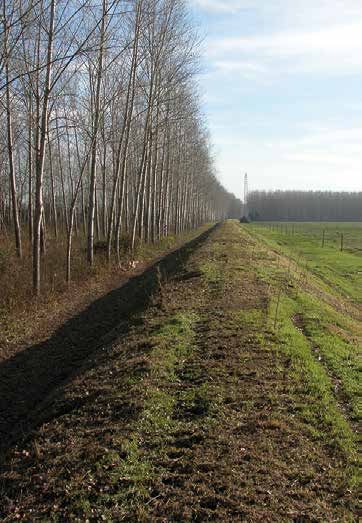
• Variabilità genetica e incrocio. Nel Parco Regionale di         • Genetic variability and breeding. In the Migliarino-San         2) Diversità animale                                                2) Animal diversity
  Migliarino San Rossore Massaciuccoli sono state sele-             Rossore-Massaciuccoli Regional Park in Tuscany (Italy)          Per valutare la diversità dei macroinvertebrati nelle diver-        To assess macroinvertabrate diversity in the different study
  zionate due aree test con lo scopo di caratterizzare la           two test areas were selected: a mixed forest stand (Area        se aree di studio sono stati usati sistemi standardizzati di        areas a standard system of traps was used. Samplings
  variabilità genetica delle popolazioni di pioppo e di stu-        A) and a scattered poplar population in the wetland area        trappolamento e sono stati condotti campionamenti in due            were carried out during spring and autumn seasons. In par-
  diare il potenziale incrocio tra popolazioni di origine natu-     of Massaciuccoli Lake (Area B) as the aim was the char-         differenti stagioni, primavera ed autunno. Inoltre, durante il      ticular, to assess the invertebrate population associated to
  rale e quelle coltivate. La prima area (Area A) è stata se-       acterization of the spatial genetic structure in poplar         periodo di fioritura, sono stati compiuti campionamenti di          planted crops, flowers of sunflower, maize, poplar and rape-
  lezionata nella zona del Serchio in corrispondenza di un          stand, and the study of the potential breeding between          macroinvertebrati sulle infiorescenze delle piante coltivate,       seed were also sampled.
  bosco misto con presenza di piante di pioppo autoctono            natural and cultivated populations. In the mixed forest         colza, mais e girasole e su pioppi naturali.                        A total of 443 species were captured, of which the insects
  vicine a una pioppeta di origine artificiale. La seconda          stand “natural” poplars were identified and classified as       Delle 443 differenti specie campionate nei differenti siti, il      were most representative and made up 77,6 % of the to-
  area (Area B) è stata selezionata nella zona del Lago di          belonging to P. alba and P. tremula species, and their          77,6 % appartengono agli insetti. Degli insetti, i coleotteri       tal number of species. Of these the coleopterans were the
  Massaciuccoli dove è presente una popolazione di piop-            hybrid P. x canescens. In the wetland area of Massaci-          sono risultati i più abbondanti (145 specie) seguiti dagli          most abundant (145 species) followed by hymenopterans
  po sparsa vicina a coltivazioni di pioppo nelle aree agri-        uccoli Lake the natural poplars are hybrids of P. nigra         imenotteri (65 specie) e dai ditteri (42 specie).                   (65 species) and dipterans (42 species).
  cole circostanti. Nell’area boschiva (Area A) sono stati          x P. deltoides. The analysis of genetic diversity reveal a      Il più alto valore di diversità dei macroinvertebrati è stato       The highest value for macroinvertebrate diversity was re-
  identificati pioppi di origine naturale e sono stati classi-      higher genetic variability in both test areas than in the       registrato durante la primavera nel campo non coltivato ad          corded during spring at the non cultivated area of the Onta-
  ficati come appartenenti alle specie P. alba e P. tremula,        Populus plantation. In both stands there is a complex           Ontanelli (Area 2; S21) mentre il valore più basso e stato          nelli locality (Area 2). Instead the lowest value occurred at
  nonché al loro ibrido naturale P. x canescens. Nell’area          spatial structure of genetic diversity. In particular the ge-   registrato in autunno nelle aree ripariali del Lago di Massa-       the site of Lago di Massaciuccoli during spring.
  umida del Lago di Massaciuccoli (Area B) i pioppi di ori-         netic diversity was higher in the Massaciuccoli Lake area       ciuccoli.                                                           As regards to the inflorescences, the highest diversity value
  gine naturale sono risultati essere ibridi delle specie P.        than in the mixed forest stand. The differences between         Per ciò che riguarda le infiorescenze, il più alto valore di di-    was recorded for the sunflower crops where the most impor-
  nigra x P. deltoides. L’analisi di variabilità ha messo in        the two test areas depended on their environmental fea-         versità è stato registrato sul girasole dove l’ordine maggior-      tant order was that of the Heteroptera, followed by those of
  evidenza un più alto valore di diversità genetica tra le          tures. The paternity analysis performed indicated that          mente campionato è stato quello degli eterotteri seguito            the Homoptera and Coleoptera.
  piante presenti nelle popolazioni di origine naturale ri-         the hybridization occurred between P3 (female) in the           dagli omotteri e dai coleotteri.                                    To study food webs a stable isotope analysis was performed.
  spetto alla diversità genetica osservata nelle piantagio-         Area A and a male of the poplar plantations.                    Le catene trofiche sono state studiate tramite l’analisi degli      This analysis showed that the isotopic signature of sunflower,
  ni di pioppo. In entrambe le aree si è riscontrata una            Some wild plant species belonging to Brassicaceae               isotopi stabili del C e del N. I risultati hanno indicato la pre-   rapeseed and poplar crops belonged to the group of C3 plants
  complessa struttura spaziale della diversità genetica. In         were selected in the cropped site called “Culatta” (Area        senza di due catene trofiche che hanno origine da due diffe-        whereas that of maize crop to that of the C4 plants. The re-
  particolare ciò si evidenzia nel sito del Lago di Massa-          3), to evaluate possible hybridization and gene flow. The       renti livelli. Nel caso della catena trofica “a” i consumatori      sults indicated the presence of two food webs originating from
  ciuccoli. Le differenze tra le due aree dipendono dalle           choice of Brassicaceae was done considering the pol-            primari sono molluschi polmonati, collemboli e blatte che si        different trophic levels. In the case of the food chain “a” the
  loro caratteristiche ambientali. L’analisi di paternità ha        linating fauna and the flowering period. Sinapis arvensis       nutrono prevalentemente di alghe unicellulari, funghi e bat-        lowest levels occurred for primary consumers such as pulmo-
  indicato che vi è stato incrocio tra una pianta femmina di        was considered as one possible candidate to hybridize           teri. Nel caso della catena trofica “b”, invece, i consumatori      nate molluscs, collembolans and blattidae that mainly feed on
  pioppo (indicata con la sigla P3) presente nell’Area A ed         with oilseed rape.                                              primari sono i lepidotteri che si nutrono prevalentemente di        fungus, unicellular algae and bacteria. In the case of the sec-
  un pioppo maschio della piantagione limitrofa.                                                                                    piante C3. In ambedue le catene trofiche individuate i livelli      ond food web “b” here again the lowest levels occurred for pri-
  Alcune specie di piante selvatiche appartenenti alla fa-                                                                          trofici più alti sono occupati da ragni e coleotteri predatori.     mary consumers such as lepidotteran but these mainly feed
  miglia delle Brassicaceae sono state selezionate nel                                                                              Va notato che solo la larva di una specie di lepidottero            on C3 plants. Predator species belonging to the Araneae and
  sito coltivato della “Culatta” (Area di studio 3), al fine                                                                        (Ostrinia nubilalis) presenta segnali isotopici tali da fare        Coleoptera order occurred in both food chains and presented
  di valutare il flusso genico ed il possibile incrocio con la                                                                      supporre una sua totale dipendenza dalle piante di mais.            the highest values. Note that only the larvae of a Lepidopteran
  varietà coltivata di colza. La scelta delle Brassicaceae è                                                                                                                                            species (Ostrinia nubilalis) perfectly matched the trophic en-
  stata fatta considerando i possibili impollinatori ed il pe-                                                                                                                                          richment for maize showing it’s total dependence to the crop.
  riodo di fioritura. Tra le specie di Brassicaceae presenti
  è stata considerata la specie Sinapis arvensis come una
  possibile candidata per l’ibridizzazione con la colza.

16                                                                                                                                                                                                                                                                  17
3) Diversità dei microrganismi                                      3) Microorganisms diversity                                        METODO DI ANALISI PER I RISCHI DI PIANTE GENETICAMEN-                ANALYSIS METHOD FOR THE RISKS OF GENETICALLY MODI-
Per quanto invisibili a occhio nudo, i microrganismi del suo-       Although invisible to the naked eye, soil microorganisms           TE MODIFICATE NELL’AMBIENTE                                          FIED PLANTS ON THE ENVIRONMENT
lo costituiscono un’ampia porzione della diversità biologica        comprise a large portion of the biological diversity on Earth.     Un indice sintetico di monitoraggio (Quick Monitoring Index          The Quick Monitoring Index (QMI) was developed to rapidly
sulla Terra.                                                        Soil microbial diversity analysis was performed on seasonal        - QMI) è stato sviluppato per valutare il rischio potenziale         assess the potential risk generated by transgenic plants, by
L’analisi della diversità microbica del suolo è stata eseguita      samples of soils (a cylinder of around 10 cm diameter and          generato dalle piante transgeniche, attraverso lo studio dei         studying and pondering any possible impact on ecosystem.
su campioni stagionali di suolo (un cilindro di circa 10 cm         20 cm depth) associated to the superficial roots of trees,         possibili impatti sull’ecosistema. A questo scopo, sono sta-         To this end, the effects of GM plants on target/non target
di diametro e 20 cm di profondità) associati alle radici su-        maples (Acer) and poplars (Populus), and herbaceous, rape-         ti considerati gli effetti di piante geneticamente modificate        species, biodiversity, gene flow, and the evolution of resist-
perficiali di alberi - aceri (Acer) e pioppi (Populus) – e piante   seed (Brassica napus) and its wild relative (Sinapis arven-        su specie target/non target, biodiversità, flusso genico. Il         ance were considered. QMI is a method that integrates a
erbacee – la colza (Brassica napus) e la sua corrispettiva          sis), in two different areas of the park, Serchio River (Fortino   QMI è un metodo che integra l’approccio quantitativo alle            quantitative approach with the guidelines on Environmen-
selvatica (Sinapis arvensis), in due differenti aree del Parco:     Nuovo) in Area 2 and Arno River (Culatta) in Area 3.               linee guida dettate dall’EFSA sulla valutazione del rischio          tal Risk Assessment (ERA) provided by the European Food
Area 2, vicino al fiume Serchio (località Fortino Nuovo) e          At first, microbial diversity was studied by isolation and cul-    ambientale (Environmental Risk Assessment - ERA). Gli in-            Safety Authority. The indexes were combined using a ma-
Area 3, vicino al fiume Arno (località Culatta).                    tivation of the microorganisms, and viable counts (CFU/g of        dici sono stati combinati utilizzando una matrice in modo da         trix in order to assess the risk for the environment and the
Inizialmente la diversità microbica è stata studiata attra-         soil) on solid media was determined.                               valutare il rischio per l’ambiente e le misure richieste per         measures required to prevent adverse effects of GM plants.
verso l’isolamento e la coltivazione di microorganismi su           However, since most soil microorganisms are not cultiva-           prevenire gli effetti avversi di piante geneticamente modifi-        This methodology requires to be validated through the anal-
un terreno di coltura solido, in questo modo si ottiene un          ble in laboratory, microbial diversity has been studied also       cate. Il metodo si propone di analizzare gli eventuali rischi        ysis of different plants and organisms, with the principal
titolo vitale dei microrganismi presenti (CFU/g di suolo). Co-      by a cultivation-independent molecular technique (T-RFLP)          associati al rilascio delle piante transgeniche, valutando           aim of analyzing the potential risks associated with the re-
munque, poiché la maggior parte dei microrganismi del suo-          by analyzing total microbial DNA directly purified from soil       singolarmente ogni evento di trasformazione (case -by-case           lease of the plants considered individually evaluating each
lo non è coltivabile in laboratorio, la diversità microbica è       samples. T-RFLP analysis gives a profile or fingerprinting         procedure) e sovrastimando gli effetti negativi rispetto ai          transformation event (using a case-by-case approach).
stata indagata anche con una tecnica molecolare (T-RFLP),           of the microbial community, from which information can be          positivi (worst-case scenarios).
indipendente dalla coltivazione dei microrganismi, analiz-          derived about its structure, that is species richness and
zando direttamente il DNA purificato dal suolo. La T-RFLP           abundance. These information are synthetized in the Shan-          LINEE GUIDA PER LA DEFINIZIONE DELLE AREE DI MONITO-                 GUIDELINES FOR THE DEFINITION OF MONITORING AREAS
fornisce un profilo o fingerprinting delle comunità microbi-        non’s index.                                                       RAGGIO E LA SELEZIONE DI RILEVANTI PARAMETRI DI MO-                  AND THE SELECTION OF RELEVANT MONITORING PARAM-
che del suolo e fornisce informazioni sulla sua struttura,                                                                             NITORAGGIO                                                           ETERS
vale a dire ricchezza di specie microbiche e numerosità del-                                                                           I dati riguardanti il livello di biodiversità nelle aree di studio   The data concerning biodiversity level in the project areas
le specie; queste informazioni sono sintetizzate nell’indice                                                                           del progetto e le principali specie individuate come “sensi-         and the individuated sensitive and relevant species were
di Shannon.                                                                                                                            bili” sono state tenute in considerazione per fornire una gui-       used to provide a monitoring guidance which is applicable
I risultati dell’analisi mostrano che:                                                                                                 da di monitoraggio alla Regione Toscana. Tale guida potrà            to the Tuscany region in order to develop a monitoring policy
1. Le comunità di batteri, rispetto a quelle fungine, hanno                                                                            essere utilizzata dalla Regione per monitorare gli ambienti          applicable in environmentally sensitive areas, in anticipa-
     un numero di cellule vitali e una ricchezza di specie                                                                             sensibili nel caso siano realizzate coltivazioni OGM in To-          tion of a possible cultivation of GM crops in Tuscany. This
     maggiori, mentre la numerosità delle specie è meno uni-                                                                           scana. La guida di monitoraggio è in linea con le direttive          monitoring guidance is in line with EC directives and poli-
     forme;                                                                                                                            della CE e le politiche sugli OGM come descritte nella diret-        cies on GMOs as described in EC2001/18 and with Italian
2. I conteggi vitali di batteri e funghi ha un andamento                                                                               tiva EC2001/18 e nelle leggi italiane e della Regione Tosca-         and Tuscany laws and other directives on nature conser-
     stagionale che è simile nei tre diversi terreni boschivi;                                                                         na, nonché con altre direttive in materia di conservazione e         vation, environmental protection and consumer protection.
3. I conteggi vitali di batteri e funghi nei campioni di suolo                                                                         protezione ambientale e di tutela del consumatore. Inoltre,          In addition the monitoring guidance is compatible with the
     di pioppi coltivati sono sempre più alti che nei campioni                                                                         la guida di monitoraggio è compatibile con le metodologie e          methods and recommendations in the EFSA (Guidance on
     provenienti da altri alberi, mentre i valori di ricchezza (e                                                                      le raccomandazioni dell’EFSA (European Food Safety Autho-            the post market environmental monitoring of GMOs, EFSA
     quindi gli indici di Shannon) sono più bassi.                                                                                     rity) (Guidance on the post market environmental monito-             2011) and with the environmental monitoring being devel-
                                                                                                                                       ring of GMOs, EFSA 2011) e con il monitoraggio ambientale            oped by DG SANCO and the Competent Authorities of the
                                                                                                                                       sviluppato da DG SANCO e dalle autorità competenti degli             Member States.
                                                                                                                                       Stati membri.

18                                                                                                                                                                                                                                                                     19
SISTEMA INFORMATIVO GEOGRAFICO PER LA VALUTAZIONE GEOGRAPHICAL INFORMATION SYSTEMS FOR ENVIRONMEN- ATTIVITÀ DI DIVULGAZIONE E COMUNICAZIONE DISSEMINATION AND COMMUNICATION ACTIVITIES
DEL RISCHIO AMBIENTALE E IL MONITORAGGIO DEGLI OGM TAL RISK ASSESSMENT AND GMO MONITORING Sono state condotte diverse attività di comunicazione e di- Several communication activities and dissemination of pro-
Un Sistema Informativo Geografico (GIS) è un software per A Geographical Information System (GIS) is a software for vulgazione dei risultati del progetto. Una parte di queste ject results were done. Part of these actions were related
l’acquisizione, la gestione, l’analisi e la restituzione di dati the management and analysis of geographic (spatial) data azioni è consistita nello sviluppo del sito Internet, nell’or- with the implementation of the website, the organization of
geografici. Il GIS è utilizzato per rappresentare su cartografie representing phenomena from the real world in term of posi- ganizzazione di seminari e nella partecipazione ad altre ini- seminars and the participation to other initiatives (network-
digitali i fenomeni del mondo reale sia in termini di posizione tion (with respect to a coordinate system) and descriptive ziative (networking). Il pubblico a cui sono rivolte queste ing). The target audience was public entities involved in the
geografica (in relazione a un sistema di coordinate ufficiale), attributes (information). These spatial data and associated attività è costituito sia da enti e organi pubblici coinvolti nel environmental monitoring of GMOs as well as general public
sia in termini di attributi (informazioni) che descrivono i feno- attributes can be layered together for mapping and analysis, monitoraggio ambientale degli OGM sia dal grande pubblico with an interest in the safeguard of the environment.
meni esaminati. Grazie alle sue capacità di analisi spaziale making GIS a practical tool for environmental monitoring interessato alla tutela dell’ambiente. The main events and dissemination tools of the project were:
il GIS viene impiegato per assistere i processi decisionali and planning used to assist the decision-making process. Gli eventi principali e gli strumenti di divulgazione del pro- • Launching event of the LIFE+ DEMETRA project: oriented
connessi al monitoraggio e alla pianificazione territoriale. The DEMETRA project used a GIS to collect spatial data for getto sono stati: toward an attendance with a high technical-scientific
Il progetto DEMETRA ha utilizzato un GIS per acquisire le the Regional Park of Migliarino – San Rossore – Massaciuc- • Evento lancio del progetto LIFE+ DEMETRA: rivolto a un background. A press conference aimed at disseminating
cartografie del Parco Regionale di Migliarino San Rossore coli. Topographic maps and thematic layers (land use map, pubblico con un background altamente tecnico-scienti- the project content to media was also done. Some local
Massaciuccoli. In particolare sono state acquisite le carte soil map, forest type map, and crop map) were acquired to fico. E’ stata organizzata anche una conferenza stam- TV channels and radio have released video and audio
topografiche e le carte tematiche (carta dell’uso del suolo, characterize the environment of the study area and its bio- pa volta alla divulgazione dei contenuti del progetto ai services.
carta dei suoli, carta della vegetazione forestale, carta delle diversity. Additionally, aerial remote sensing data and GIS mass media. Alcune TV e radio locali hanno realizzato • Mid term workshop: the activities and first preliminary re-
coltivazioni) necessarie a caratterizzare i diversi ambienti del tools were used to assist field plot selection and field works servizi video e audio. sults of the project were presented to an audience of ex-
Parco. Inoltre, il GIS è stato utilizzato per agevolare la scelta planning. • Workshop a metà progetto: le attività e i primi risultati perts in the field of GMOs and environmental monitoring.
delle aree di studio e per pianificare i rilievi sul campo. The spatial dataset was used to develop GIS-based models preliminari del progetto sono stati presentati a un pub- • Video of DEMETRA illustrating the study area and ex-
I database spaziali sono stati poi utilizzati per sviluppare dei of the Quick Monitoring Index. To do this, a multi-criteria blico di esperti del settore degli OGM e del monitoraggio plaining the importance of the project with interview to
modelli del QMI. Tali modelli sono stati realizzati applicando spatial analysis was performed to assess the environmen- ambientale. the experts.
delle analisi multi-criteriali. I risultati ottenuti con queste ana- tal risk generated by simulated GMO cultivations within the • Video di DEMETRA che illustra l’area studio e spiega • Conference of the Network of GMO Free European Re-
lisi sono delle cartografie che indicando quali sono le zone study area. l’importanza del progetto con interviste ad esperti. gions: networking with stakeholders interested in GMO
del Parco che dovrebbero essere monitorate in presenza di The results of the DEMETRA project show how GIS might be • Conferenza della Rete europea delle regioni e delle au- monitoring
coltivazioni OGM, in quanto sottoposte a rischio ambientale. used to assess the interaction between GMO crops and the torità locali libere da OGM: instaurazione di un rapporto • Training workshop on GMOs: seminars to students inter-
In sintesi, i risultati del progetto DEMETRA mostrano come receiving environment, and how geographic data might be con finanziatori interessati al monitoraggio degli OGM. est in forest-ecosystem biodiversity
il GIS possa essere utilizzato per valutare l’interazione tra used to select checkpoints for GMO monitoring. • Training workshop sugli OGM: seminari per studenti inte- • Public event “Terra Futura”: a three days event opened
colture OGM e l’ambiente ricevente, e come i dati geografici ressati alla biodiversità dell’ecosistema boschivo. to the public (families, generations and all the people
possano essere impiegati per selezionare i siti di monito- • Evento pubblico “Terra Futura”: un evento di tre giorni who care for the environment) to present DEMETRA pro-
raggio degli OGM. aperto al pubblico (famiglie, adulti, giovani, tutti interes- ject and its importance for natural Tuscan territories.
sati ai temi ambientali) per presentare il progetto DEME- The experts of the project carried out practical activities
TRA e la sua importanza per i territori toscani. Gli esperti for all ages on some issues relating to the environment
del progetto hanno condotto attività pratiche di labora- with particular attention to plants and its “inhabitants”
torio per adulti, ragazzi e bambini su argomenti collegati from micro to macro-organisms.
all’ambiente con particolare attenzione alle piante e ai • Participation to national and international conference:
suoi “abitanti”, dai micro ai macro organismi. SIGA, SISEF, FISV, SIMGBM, IUFRO Tree Biotechnology,
• Partecipazione a conferenze nazionali e internazionali: ISBGMO, ISHS, EIGMO, SBI, BIT’s 2nd Annual World Con-
SIGA, SISEF, FISV, SIMGBM, IUFRO Tree Biotechnology, gress of Biodiversity, Ecology and Environment.
ISBGMO, ISHS, EIGMO, SBI, Secondo Congresso Annua- • Final conference of the LIFE+ DEMETRA project: final re-
le Mondiale su Biodiversità, Ecologia e Ambiente (BIT). sults were presented to specialists, public and private en-
• Conferenza finale del progetto LIFE+ DEMETRA: i risulta- tities involved in the environmental monitoring of GMOs.
ti finali sono stati presentati a specialisti, enti pubblici e
privati coinvolti nel monitoraggio ambientale degli OGM.
20 21Puoi anche leggere