PRELIMINARY DATA ON SLOW-MOVING LANDSLIDES-AFFECTED URBAN AREAS THROUGH GEOLOGICAL, GEOMORPHOLOGICAL AND INSAR ANALYSIS
←
→
Trascrizione del contenuto della pagina
Se il tuo browser non visualizza correttamente la pagina, ti preghiamo di leggere il contenuto della pagina quaggiù
DOI: 10.4408/IJEGE.2021-01.S-02

  PRELIMINARY DATA ON SLOW-MOVING LANDSLIDES-AFFECTED URBAN
AREAS THROUGH GEOLOGICAL, GEOMORPHOLOGICAL AND INSAR ANALYSIS

            Giuseppe CIANFLONE(*), Massimo CONFORTI(**), Sergio SOLERI(***) & Fabio IETTO(*)

                          Università degli Studi della Calabria - Dipartimento di Biologia, Ecologia e Scienze della Terra (DiBEST)
                         (*)

                                                - Via P. Bucci, cubo 15B - 87036 Arcavacata di Rende (Cosenza, Italy)
     (**)
          Consiglio Nazionale Ricerche (CNR), Istituto di Ricerca per la Protezione Idrogeologica (IRPI) - Via Cavour, 4 - 87036 Rende (Cosenza, Italy)
                                  (***)
                                        Istituto Prove Geotecniche - Via Ortomatera, 21 - 87040 Castrolibero (Cosenza, Italy)
                                                             Corresponding author: fabio.ietto@unical.it

EXTENDED ABSTRACT
     In Italia, negli ultimi decenni, i danni causati da frane e inondazioni sono in crescita esponenziale soprattutto a causa dell’espansione
urbanistica avvenuta anche in aree a rischio idrogeologico più o meno elevato. Diretta conseguenza è stato, quindi, il forte incremento
di danni a edifici, infrastrutture e blocco di attività commerciali procurando ingenti perdite economiche e talvolta elevati rischi per
l’incolumità pubblica. Con lo scopo di prevenire i rischi idrogeologici e/o valutarne le condizioni di rischio, diviene sempre più alto
l’interesse allo studio di nuovi sistemi di controllo e previsione dei fenomeni franosi da parte della comunità scientifica mondiale. A tal
fine, nell’analisi dei fenomeni franosi è sempre più diffuso, sia nel mondo scientifico che professionale, l’applicazione di tecniche di
interferometria satellitare che affiancano le usuali metodologie diagnostiche di campo.
     Il presente lavoro si prefigge di studiare i diffusi fenomeni franosi presenti in un’area localizzata sul versante orientale della Catena
Costiera Calabrese e confinante con il Bacino del Crati (Calabria centrale). L’area di studio comprende i centri abitati di Cavallerizzo,
San Martino di Finita e Rota Greca che ricadono nella provincia di Cosenza e sono tutti coinvolti da eventi franosi responsabili di dif-
fusi danni di varia entità. La presente ricerca si basa, quindi, su un attento rilevamento geologico e geomorfologico, su diversi sondaggi
geognostici eseguiti nelle aree urbane, su una indagine geoelettrica che ha raggiunto la profondità di 120 m nell’abitato di San Martino
di Finita, su ripetute letture di movimenti profondi ottenuti dall’impiego di un inclinometro nell’abitato di Rota Greca e, infine, su dati
di interferometria satellitare derivanti da un’analisi temporale di immagini comprese tra il 1992 e il 2010.
     Da un punto di vista geologico, l’area di studio è attraversata dalla faglia San Fili-San Marco Argentano che, con cinematismo di
tipo normale, pone a contatto il complesso cristallino metamorfico, costituente la struttura della Catena Costiera, con i depositi sedimen-
tari di riempimento del Bacino del Crati. L’ammasso roccioso lungo la zona di taglio si presenta fortemente cataclasizzato favorendo
l’accumulo di acque sotterranee. Infatti, elevati risultano gli accumuli idrici lungo la zona di contatto tra le due litologie a diversa
permeabilità, come testimoniato dalla presenza di innumerevoli sorgenti, anche con portate consistenti, dislocate lungo l’allineamento
tettonico. Un deposito colluviale, con spessori che variano da un minimo di 10 m fino a 64 m e costituito da clasti di origine cristallino
metamorfica immersi in una matrice sabbiosa, ricopre parzialmente il substrato metamorfico della Catena Costiera e estesamente i de-
positi sedimentari del Bacino del Crati. Pertanto, elevate acclività dei versanti, forte fratturazione dei complessi rocciosi, scarsa qualità
meccanica delle rocce e elevati accumuli idrici, sono tutti fattori che rendono l’area di studio particolarmente predisposta a fenomeni
franosi.
     L’indagine geomorfologica ha consentito il riconoscimento di 225 fenomeni d’instabilità nell’area di studio con una densità di frana
pari a 10.2 frane/km2. Di questi fenomeni gravitativi, 144 sono stati classificati attivi e il rimanente in stato quiescente. Riguardo i cine-
matismi di frana, 183 sono di tipo scivolamento, 36 di tipo complesso e solo 6 di tipo colata. I fenomeni complessi risultano solitamente
caratterizzati da cinematismi di tipo scivolamento nella parte alta e colata nella restante porzione valliva. La profondità delle superfici
di scivolamento varia da pochi metri (solitamente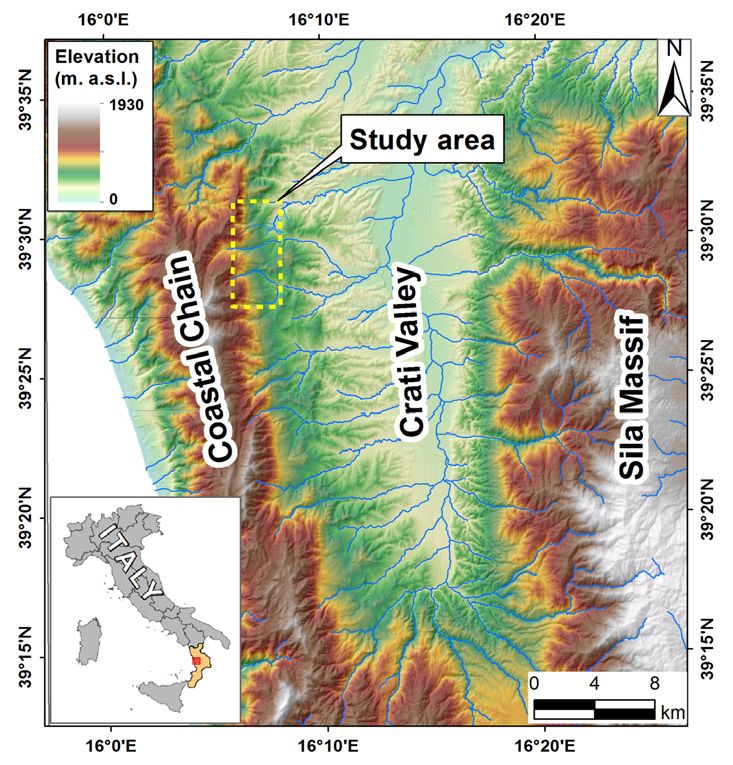
G. CIANFLONE, M. CONFORTI, S. SOLERI & F. IETTO

     ABSTRACT                                                                       data of the boundaries and the state of activity of slow-moving
          The research focuses on the instability phenomena occurring               landslides (e.g., Cigna et alii, 2016; Cianflone et alii, 2018;
     on the eastern edge of the Calabria Coastal Range using                        Zao & Lu, 2018). Among remote sensing techniques for
     geological and geomorphological investigations, geognostic                     landslide monitoring the interferometric synthetic aperture
     surveys and InSAR remote sensing technique. The study area is                  radar technique (InSAR) is the most employed to analyze
     located in Cosenza province (Calabria, south Italy) and includes               different types of ground movements, such as subsidence,
     Cavallerizzo, Cerzeto, San Martino di Finita and Rota Greca                    landslides, deformation associated with fault and volcanic
     villages. The geological setting is dominated by a variety of                  activity (Cianflone et alii, 2015; Da Lio & Tosi, 2018; Cigna
     metamorphic-crystalline rocks constituting the Coastal Range                   et alii, 2020).
     structure. A normal fault, N-S oriented and located on the eastern                 In Calabria (southern Italy) instability processes are
     side of the Costal Range, is responsible of the tectonic contact               widespread phenomena, involving areas characterized by high
     between the metamorphic rocks and the sedimentary deposits                     local reliefs dominated by fault trending, where weathered and
     of the Crati Basin; while, a colluvial deposit overlies both the               deeply tectonized rocks occur (Sorriso-Valvo et alii, 1996;
     crystalline and the Neogene terrains. Continuous boreholes                     Tansi et alii, 2016; Borrelli & Gullà, 2017; Conforti &
     showed that the thickness of this deposit ranges from 10 to 65                 Ietto 2019, 2020). The aim of this research is to investigate
     m. The latter is involved in widespread landslides causing severe              on the landslides occurring on the eastern edge of the
     harmful to buildings and infrastructures. Envisat ascending                    Calabria Coastal Chain. The research was based on geological
     dataset, processed by SBAS multi-temporal InSAR technique,                     and geomorphological surveys coupled with geognostic
     was employed to measure the displacement time series referred to               investigations and InSAR remote sensing technique. Envisat
     the interval 2003-2010. The data acquired along Envisat ascending              datasets, processed by SBAS multi-temporal InSAR technique,
     orbit, which better cover the east-facing study area, showed a                 was employed to measure the displacement time series referred
     ground movement rate up to -6.5 mm/yr for the landslides in the                to the interval 2003-2010. The InSAR technique, compared to
     urbanized areas; whereas, ERS descending orbit (ascending data                 other procedures, shows the advantage to supply a high density
     are not available) showed movement rate of 7.5 mm/yr.                          of measurement points in large areas, providing time series
                                                                                    of movement with high precision. The investigated area falls
     Keywords: InSAR, geognostic surveys, landslides, Calabria, Italy               within Cosenza province, including Cavallerizzo, San Martino
                                                                                    di Finita and Rota Greca villages involved by historic slow-
     INTRODUCTION                                                                   moving landslides.
          In the last decades, building damage caused by landslides
     in urban areas are increased mainly because of the urban                       GEOGRAPHICAL,  GEOLOGICAL                                       AND
     expansion occurred on landslide-prone slopes (e.g., Ferlisi et                 GEOMORPHOLOGICAL SETTING
     alii, 2015; Guerriero et alii, 2019). Destructive landslides are                   The study area is located in the northern sector of the Calabria
     usually triggered by downpour and/or prolonged rainfall events,                region (South Italy). In particular, it falls on the left flank of the
     earthquakes and human landscape modifications, causing
     fatalities, severe damage to human activities and significant
     economic loss (e.g., Ietto et alii, 2014; Bartelletti et alii, 2017;
     Diodato et alii, 2017). Weathering processes represent another
     significative predisposing factor to the instability phenomena,
     because these processes combined with morphological,
     lithological, tectonic and climatic factors, generate a significant
     decay of the physical-mechanical properties of the original
     rocks (Calcaterra & Parise, 2010; Ietto et alii, 2015a, 2016;
     Perri et alii, 2016; Borrelli et alii, 2016).
          Numerous researches have led to a deepening of knowledge
     about the instability processes and their prediction (e.g.
     Costanzo et alii, 2016; Elmoulat et alii, 2020). Thus, several
     innovative instruments are available to monitor the activity
     of slopes that interact with human settlements. Among these,
     particular interest from scientific community has been devoted
     to remote sensing technique used to obtain the displacement                    Fig. 1 -    Location map of the study area

22   Italian Journal of Engineering Geology and Environment, 1 (2021)   © Sapienza Università Editrice                               www.ijege.uniroma1.it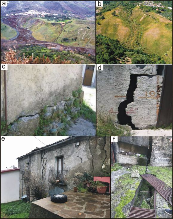
PRELIMINARY DATA ON SLOW-MOVING LANDSLIDES-AFFECTED URBAN AREAS THROUGH GEOLOGICAL, GEOMORPHOLOGICAL AND
INSAR ANALYSIS

Crati valley along the foothill zone of the eastern edge of the                crosses the study area. The San Fili – San Marco Argentano
Calabria Coastal Chain (Fig. 1). Elevation ranges between 982                  fault is a regional tectonic segment 30 km long. It drives the
and 193 m a.s.l. with an average value of 479 m a.s.l. Slope                   uplifting of metamorphic-crystalline rocks, forming the Coastal
gradients range from 0 to 63 degrees, with an average of 18                    Chain, with respect to the sedimentary deposits that constitute
degrees (Fig. 2). The studied area covers a surface of 22.1 km2                the Crati graben filling. The structure of the Coastal Chain is
including Cavallerizzo, Cerzeto, San Martino di Finita and Rota                made up of several nappes mainly constituted by ophiolitic
Greca villages belonging to the Cosenza province. The climate                  (Amodio-Morelli et alii, 1976; Liberi & Piluso, 2009; Filice
is sub-humid, with average annual precipitation of 1300 mm                     et alii, 2015). In the study area the recognized ophiolitic unit is
and average temperature of about 15°C. Rainfall peaks occur                    composed by metabasalts topped by calcschists with thin levels
in the period October–March, during which landslides and                       of metapelite (Jurassic in age) (Fig. 3). This ophiolitic unit is
severe water erosion processes may trigger (Capparelli et alii,                overthrust by the continental Castagna Unit, which consists of
2012; Ietto & Perri, 2015; Conforti & Buttafuoco, 2017;                        medium to high-grade metamorphic para- and ortho- gneisses
Borrelli et alii, 2019).                                                       (Permian in age). The sedimentary deposits of the Crati basin
                                                                               (Lanzafame & Tortorici, 1981; Colella et alii, 1987) are
                                                                               mainly composed, from bottom to top, by marl and gypsum
                                                                               layers (Miocene in age) that locally pass upward to Pliocenic
                                                                               conglomerates. Sands and sandstones (Plio-Pleistocene in age)
                                                                               characterize the upper part, followed by clay deposits (Plio-
                                                                               Pleistocene in age). Continental red fan-conglomerate (Late
                                                                               Pleistocene in age), made up of igneous and metamorphic
                                                                               rock fragments in a sandy matrix, dominates some parts of the
                                                                               valley areas. Furthermore, colluvial deposits (Holocene in age),
                                                                               made up of metamorphic rocks in sand matrix, overlie both the
                                                                               metamorphic basement and the Neogene sedimentary terrains.
                                                                               East-West trending subvertical faults are also present, marking
                                                                               the directions of the torrential axes where alluvial deposits
                                                                               cropping out.

Fig. 2 -   Slope gradient map of the study area

     The Calabria Coastal Chain is mainly constituted by
metamorphic-crystalline rocks belonging to the northern sector
of the Calabria–Peloritani Arc (CPA in Amodio-Morelli et
alii, 1976; Bonardi et alii, 1976). The CPA is an orogenic
Mediterranean belt originated by crustal terranes in the
accretionary wedge during the final stage of the Africa-Europa
collision (Ben Avraham et alii, 1990; Vai, 1992).
     The Crati valley is a graben (Lanzafame & Tortorici,
1981) bounded by North-South striking normal fault systems
                                                                               Fig. 3 -    Geostructural map of the study area
active since Late Pliocene (e.g., Tortorici et alii, 1995; Tansi et
alii, 2007). On the eastern side of the Coastal Chain, the master                  The geological setting of the area, characterized by a
normal fault is represented by an active N–S strike fault, named               tectonic contact between medium and low permeable rock
San Fili – San Marco Argentano (Tortorici et alii, 1995), which                masses, forming respectively the Coastal Chain and the infilling

Italian Journal of Engineering Geology and Environment, 1 (2021)   © Sapienza Università Editrice                                www.ijege.uniroma1.it   23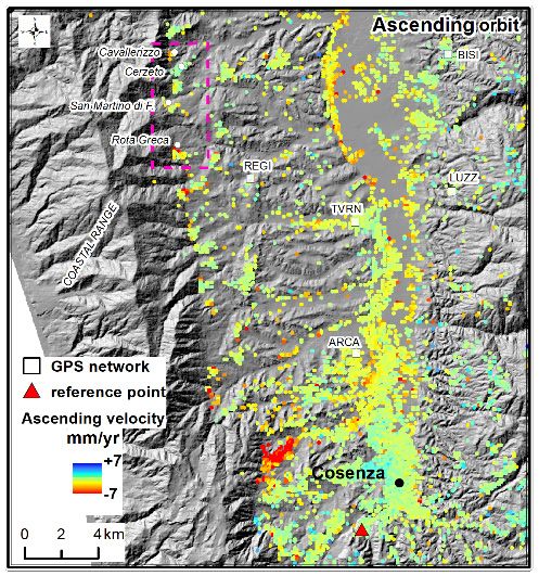
G. CIANFLONE, M. CONFORTI, S. SOLERI & F. IETTO

     deposits of the Crati basin, favors the presence of abundant                   Geological and Geomorphological data
     groundwater storage along the contact zone, where numerous                         Detailed geological and structural field investigations,
     springs occur. The groundwater storage is furthermore favored                  integrated with air photo interpretation, were employed to map
     by the presence of a large volume of brittle fault rock produced               both tectonic lineaments and rock types involved in instability
     by the master fault. Therefore, in the whole studied area, the                 processes. Subsequently, a geomorphologic analysis was carried
     rock masses surrounding the master fault are weak and intensely                out in order to recognize the distribution, geometry, activity
     cataclasized, showing a high predisposition to the instability                 state and type of landslides according to Cruden & Varnes
     phenomena.                                                                     (1996). The landslides were recognized and mapped at 1:5000
         The geomorphology of the study area reflects the complex                   scale using a combination of aerial photographs, Google Earth
     interplay between the geological and structural arrangement.                   satellite images, landslide inventories of the Basin Authority
     Indeed, the landscape in western portion of the studied area,                  of the Calabria region and detailed field surveys. All collected
     shaped on Palaeozoic metamorphic rocks, is dominated by a                      data were digitized, managed and analyzed using a geographic
     rugged topography with high dipping slopes more than 30° in                    information system (GIS) and then employed for the construction
     average. The eastern sector, instead, is mainly characterized                  of a database containing landslide attributes.
     by rounded and gentle landform, shaped on the Neogene-
     Quaternary sedimentary terrains (Fig. 3). Usually, the areas                   Geognostic data
     dominated by competent rock show high-gradient slopes (Fig.                        In Cavallerizzo village, several municipal geognostic
     2). Several deep and narrow incisions, locally fault controlled                investigations were performed in the period 1982-1999
     (Conforti et alii, 2014), dissect the slopes mainly with a sub-                (Guerricchio, 1998; Rizzo, 2005, 2008), among these, five
     dendritic pattern and subordinately with an angular-like pattern.              continuous boreholes (Fig. 3), ranging from 40 to 75 m in depth,
     Furthermore, the mountain landscape shows triangular facets                    were analyzed in this research.
     on the N–S trending fault scarp and minor morphotectonic                           In San Martino di Finita one continuous borehole, drilled up
     structures as straight channels, saddles and straight ridges                   to 70 m depth, and one electrical resistivity tomography, were
     (Tortorici et alii, 1995).                                                     performed between 2009 and 2010 years (Tansi, 2010) (Fig. 3).
         High relief energy, steep slopes, severe tectonic fracturing,              The borehole was located close to the tomography tracing allowing
     poor quality lithologies and abundant groundwater, drive                       a useful comparison of the relative collected data. The resistivity
     the shallow and deep-seated landslides involving both the                      survey was conducted along one line, about 780 m long, that
     Coastal Chain rock masses and the sedimentary deposits of the                  crosses the urbanized area. Data were acquired by a Syscal R2 (Iris
     Crati basin (e.g., Casagli et alii, 2006; Iovine et alii, 2006;                Company) georesistivimeter, equipped with a multielectrode cable
     Gattinoni, 2009; Capparelli et alii, 2012; Conforti et alii,                   with 39 channels spaced at 20 m intervals, allowing to reach an
     2014; Cianflone et alii, 2018).                                                investigation depth of 120 m.
                                                                                        Finally, in Rota Greca village, three continuous drilling of
     DATA AND METHODS                                                               vertical boreholes, carried out up to 20 m depth in 2014 (Luci &
          The study of the instability phenomena requires the analysis              Liguori, 2014), were used (Fig. 3). In order to gain some insight
     and interpretation of several geological, geomorphological                     into the kinematics of the slope, deep displacement has been
     and geotechnical information that interact reciprocally and are                periodically measured between 2014-2019 using an inclinometer
     obtained through different methodologies, such as: geological                  placed in the borehole B7. The measurements were carried out
     and geomorphological surveys, geognostic boreholes, seismic                    two times for year, except for the 2016 year due to a malfunction
     and geoelectric survey and InSAR analysis (e.g., Ietto et                      of the instrument. The used inclinometer sensor type was biaxial
     alii, 2012, 2015a, 2018; Cigna et alii, 2016; Cianflone et                     servo-accelerometer MK4 type, having an accuracy of ± 5°. The
     alii, 2018; Faccini et alii, 2019). To this regard, since 1980s,               collected data were elaborate through the Arts-Boviar Inclinometro
     several geognostic surveys were performed in the area between                  3.5 software.
     Cavallerizzo and Rota Greca villages (Guerricchio, 1998;
     Rizzo, 2005, 2008; Casagli, 2006; Tansi, 2010; Luci &                          InSAR data
     Liguori, 2014) to study the landslides in the urbanized areas.                     In this work, we used ERS dataset, acquired along the
     Starting from these data, the research was based on a new                      descending track in the period 1992-2000 (ascending data
     reading of the previous geognostic data, on new geological and                 are not available). We employed these datasets because they
     geomorphological field investigations and on data collected by                 allowed us to monitoring the ground deformations in a longer
     Synthetic Aperture Radar Interferometry (InSAR) technique.                     period, which is previous to significant instability events (a.g.
     The used investigation methodologies are described below.                      Cavallerizzo landslide in 2005). These data were processed

24   Italian Journal of Engineering Geology and Environment, 1 (2021)   © Sapienza Università Editrice                             www.ijege.uniroma1.it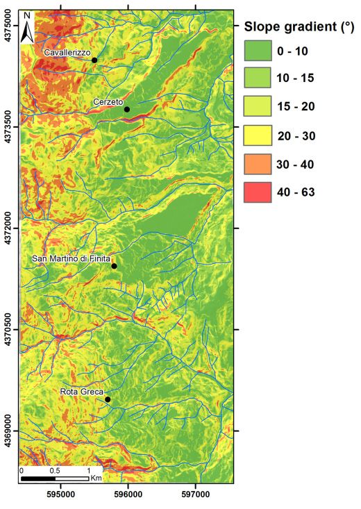
PRELIMINARY DATA ON SLOW-MOVING LANDSLIDES-AFFECTED URBAN AREAS THROUGH GEOLOGICAL, GEOMORPHOLOGICAL AND
INSAR ANALYSIS
by PS technique (Ferretti et alii, 2001) within the scope of covering a surface of 8.6 km2 that corresponds to about 38%
the extraordinary plan of environmental remote sensing and of the surveyed area and to 10.2 landslide/km2 density (Table
realized by the Italian Ministry for the Environment Land and 2). The size of the inventoried landslides spans several orders,
Sea (http://www.pcn.minambiente.it/mattm/progetto-piano- from a minimum value of 276 m2 to a maximum one of 721075
straordinario-di-telerilevamento/). Furthermore, we considered m2, whereas the average area is 37490 m2 (Tab. 2). According
the Envisat ascending datasets used by Cianflone et alii (2018) to classification scheme proposed by Cruden & Varnes
to investigate the ground deformations in the whole Crati valley. (1996), the inventoried mass movements were grouped into
We chose to use the dataset from ascending orbit because it three main landslide typologies: slide, complex and flow types.
better covers the east-facing study area respect the descending (Fig. 4a). It was found that the higher number of landslides
orbit. The ascending dataset includes 38 images acquired in can be classified as slides (183) and they account the 81.3%
2003–2010 (Tab. 1). Pairs of images were selected to apply of the collected landslides. Only six flow-type landslides were
constraints on the maximum orbital separation (350 meters for mapped, constituting about 2.7% of the checked unstable
the perpendicular baseline) and temporal distance (700 days for phenomena; whereas, 16% (36) is the percentage reached for
temporal baseline) between the two passages, aimed to minimize the complex movements (Tab. 2 and Fig. 4b). The complex
spatial and temporal decorrelation effects (Berardino et alii, landslide, consisting of multiple kinematic types, are mainly
2002). The Envisat dataset was processed by means of SBAS slides evolving into flow-like landslides. Multi-temporal aerial
multi-temporal InSAR technique (Berardino et alii, 2002) photos interpretation coupled to field investigations allowed to
to obtain the displacement time series and the mean ground
velocity map. In detail, the SBAS algorithm on the Geohazard
Exploitation Platform (GEP) (https://geohazards-tep.eo.esa.int),
developed by ESA, was used. 3D unwrapping by the algorithm
is performed by this SBAS version, which not include external
atmospheric model. For the topography subtraction step the 90
meters SRTM digital elevation model (DEM) was utilized, while
atmospheric contribution is removed by “standard” filtering
in time and space. Ascending data were processed applying a
multi-looking factor equal to 4 m for the range direction and
20 m for the azimuth with a final ground resolution of 90 m
(Cianflone et alii, 2018 and references therein).
Tab. 1 - Characteristics of the satellite images employed in the studied
area
Velocity maps in the Line of Sight (LoS) of satellite SAR
geometry were produced by Envisat ascending data processing.
CGPS (Continuous Global Positioning System) data
were used to validate InSAR LoS velocities. In detail, InSAR
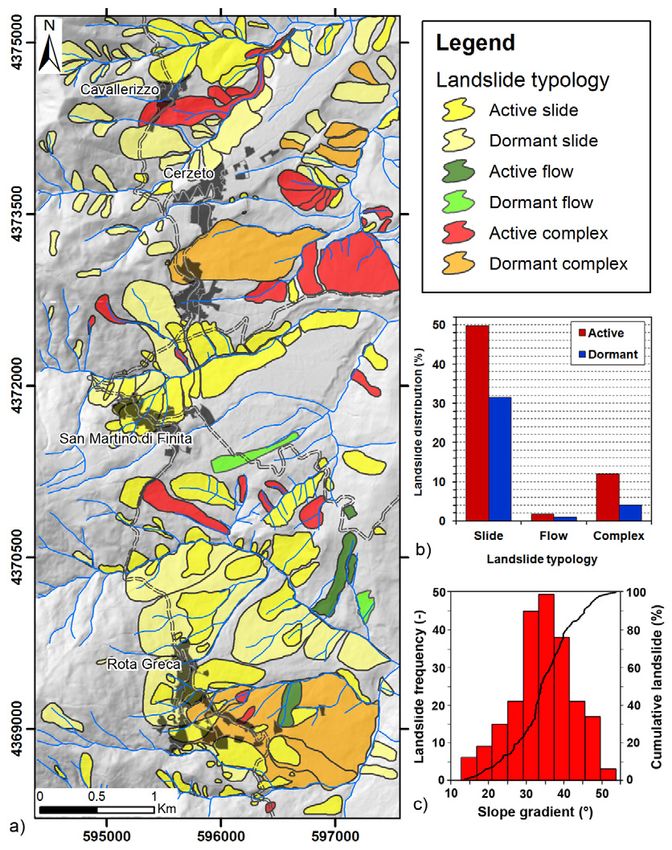
Fig. 4 - a) Landslide inventory map of the study area; b) Distibution
velocities recorded in a circular buffer with radius of 200 m of landslide typology; c) Frequency distribution of the
around CGPS sites were compared with the velocities recorded landslides with respect to slope gradient
by CGPS, obtaining maximum differences of ±1.5 mm/yr for
the ascending tracks (for more details see Cianflone et alii, distinguish active (64%) from dormant (36%) landslides.
2018). Failure surface depth ranges from shallow (20 m). The deep-seated landslides involve the cover
RESULTS materials and/or the bedrock; whereas, most of the shallow
Landslides features landslides affect cover materials or surficial weathered bedrock.
The geomorphological analysis provided detailed data In many cases, shallow landslides are a partial reactivation of
about the spatial distribution, typology and state of activity of pre-existing dormant deep landslides.
the landslides. A total of 225 landslides (Fig 4a) were mapped, Geological surveys showed that the instability processes
Italian Journal of Engineering Geology and Environment, 1 (2021) © Sapienza Università Editrice www.ijege.uniroma1.it 25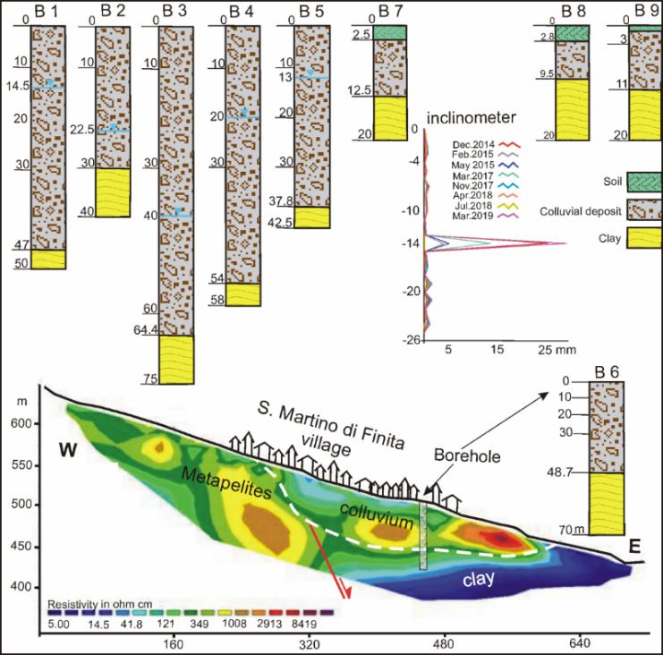
G. CIANFLONE, M. CONFORTI, S. SOLERI & F. IETTO

     involve mainly the colluvial deposits, which is produced by                      landslides in the northern and southern part (Fig. 4a). Instead,
     weathering processes and by the cataclasic zone generates by                     the central and some of the southern part of the urbanized area
     the fault movements. The depth of the failure surfaces is mainly                 are involved by active instability phenomena with a slide-type
     located between the bottom of colluvial deposit and the top of                   kinematic, causing severe damage to buildings and infrastructures
     the sedimentary deposit of the Crati basin. Mass movements                       (Figs. 5e and 5f). The landslides are characterized by deep failure
     were also observed in the metamorphic-crystalline rocks,                         surfaces and are triggered close the master fault scarp that crosses
     constituting the Coastal Chain, and subordinately in the Plio-                   the whole village. In this area, the triggering of small rapid
     Pleistocenic deposits of sand and clay.                                          landslides, allocated in unstable areas classified as dormant or
          Field observations suggested that the tectonic deformations,                active, is frequent.
     coupled with the intense jointing state of rock masses, control
     the spatial distribution of some mass movements. Indeed, several
     landslides were observed close to the tectonic lineaments, which
     are the cause of a pre-existing weakness zone in the rock mass.
     The poor mechanical state of the tectonized rocks encourages
     the groundwater drainage and the consequent deep weathering
     processes, both held responsible of instability phenomena.
     (Conforti & Ietto, 2019, 2020). Furthermore, also the slope
     gradient seems to play a key role on the distribution of landslide
     occurrences. Indeed, more than 93% of landslides occur on
     slopes with gradients more than 20°, which characterize only
     the 37% of the study area (Fig. 4c).
          In Cavallerizzo village, evidences of active landslides
     were recognized mainly in northern and southern part of the
     urbanized area, where many buildings and infrastructures are
     damaged. Indeed, in 2005 the southern portion of the village
     was involved in a large complex-type landslide (e.g., Iovine et
     alii, 2006; Gattinoni, 2008) (Fig. 5a), causing the abandonment
     of the entire village and its relocation in a new area. Instability
     phenomena occur also along the village perimeter toward the

                                                                                      Fig. 5 -    a) Cavallerizzo landslide occurred on march 07 2005; b)
                                                                                                  Cavallerizzo landslide, photo dated 2020; c and d) Landslide
                                                                                                  damage in San Martino di Finita Village; e and f) Landslide
                                                                                                  damage in Rota Greca Village

                                                                                      Geognostic Surveys
     Tab. 2 -   Distribution of type, activity, count, area of landslides and             In the urbanized area of Cavallerizzo village, the continuous
                summary of landslide size for the landslide inventory of the          sampling of five drilled boreholes showed the presence of two
                study area
                                                                                      distinct horizons. The shallower horizon is composed by a
     valley (Fig. 4a). Anyway, geomorphological evidences of                          colluvial deposit constituted by heterometric clasts of metabasalts
     landslides involving the historic center were not recognized.                    and metapelites immersed in a poor sandy matrix. This rock
         In San Martino di Finita village the whole urbanized area                    fragments belong to the metamorphic-crystalline complex
     is affected by several large active instability phenomena (Fig.                  of the Coastal Chain. The colluvial deposit was found in all
     4a), causing heavy damage to buildings (Figs. 5c and 5d) and                     boreholes with variable thickness, ranging from 30 to 64.4 m
     infrastructures. The landslides are slide-type with deep failure                 (Fig. 6), depending from the slope morphology. Beneath the first
     surfaces and are triggered close to the San Fili-San Marco                       horizon, a bed of Plio-Pleistocene clay, belonging to the infilling
     Argentano fault scarp. Toward valley areas, the instability                      sedimentary deposits of the Crati basin, was found a variable
     phenomena show composite slope movements and a partial                           depth in all drilled boreholes. A water table was also found within
     overlap of secondary landslide scarps occurs.                                    the boreholes at variable depth. The analysis of the piezometric
         Rota Greca village is involved by two large dormant                          data shows a great storage of water with a preferential drainage

26   Italian Journal of Engineering Geology and Environment, 1 (2021)     © Sapienza Università Editrice                                 www.ijege.uniroma1.it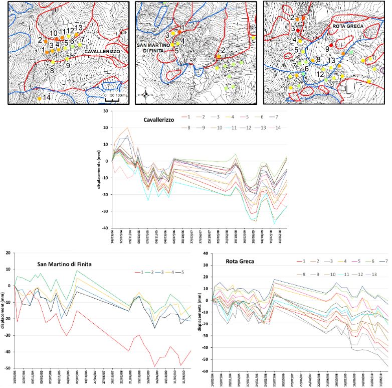
PRELIMINARY DATA ON SLOW-MOVING LANDSLIDES-AFFECTED URBAN AREAS THROUGH GEOLOGICAL, GEOMORPHOLOGICAL AND
INSAR ANALYSIS

                                                                                    latter is comparable to the clay layer, lying beneath the colluvial
                                                                                    deposit observed by the borehole core samples. The collected
                                                                                    data enabled to construct the geological section B-B’ in Fig. 7.
                                                                                         Three boreholes were carried out in Rota Greca village
                                                                                    (Fig. 6), showing the presence of a first thin horizon of soil with
                                                                                    thickness up to about 3 m. The second horizon is constituted by a
                                                                                    colluvial deposit of metapelites and gneiss heterometric clasts in
                                                                                    a poor sandy matrix. The thickness of this layer ranges between
                                                                                    9.5 and 12.5 m, beneath of which a Plio-Pleistocene clay horizon
                                                                                    was found up to the investigate depth of -24m. Only one borehole
                                                                                    (B7 in Fig. 6) was equipped with an inclinometer, where annual
                                                                                    measures were collected since 2014. Inclinometer displacements
                                                                                    have clearly revealed the existence of a slide surface located
                                                                                    between the bottom of colluvial deposit and the top of clay
                                                                                    layer. Indeed, the sliding surface is located approximately at -14
                                                                                    m depth, where the displacements reached up to 30 mm. This
                                                                                    value suggests the clear presence of a slow-moving landslide in
                                                                                    the urban center. The collected geological data, obtained from
                                                                                    field surveys and drilled borehole allowed the construction of the
Fig. 6 -   B1-B5 Boreholes drilled in Cavallerizzo village; B7-B9 and               geological section C-C’ in Fig. 7.
           inclinometer are the geognostic surveys performed in Rota
           Greca village; B6 and Electrical resistivity tomography
           section are the geological investigations carried out in San
           Martino di Finita village. See Fig. 3 for locations of boreholes
           and tomography lineament

axis in correspondence of the borehole B3 located in the landslide
area triggered in 2005. The set of borehole data, coupled to
geological surveys, allowed the construction of the geological
section A-A’ in Fig. 7.
     The geognostic surveys carried out in San Martino di Finita
village consist in one borehole and one electrical resistivity                      Fig. 7 -    Geological cross-section passing through the urbanized
                                                                                                areas; see Fig. 3 for location
tomography. The borehole core samples showed the existence of
a first level of colluvial deposit constituted by heterometric clasts
of metapelite and calcshists in a poor sandy to clayey matrix.                      InSAR survey
The thickness of this first horizon was of 48.7 m, beneath of                            In Cavallerizzo village surrounding, the PS ERS descending
which a level of Plio-Pleistocene clay was found. (Fig. 6). The                     (Fig. 8) shows velocities between 1.3 and 3.5 mm/yr in the middle
borehole data were compared with the information provided by                        part of the urban area. The area is also well covered by Envisat
the tomography tracing that cross the borehole axis. Terrains with                  data acquired along ascending orbit (Fig. 9). Coherent pixels were
high electrical resistivity values (color from green to yellow/                     recognized by Envisat ascending dataset in the landslide areas
brown in Fig. 6) were found in uppermost part with respect to                       located both in upslope and in downslope zones with respect to
San Martino di Finita village and San Fili-San Marco Argentano                      the village. The pixels showing highest mean velocities (about
fault. These electrical values are attributable to metapelite and                   -4 mm/yr), along LoS, are located upslope (Fig. 10). Instead, in
calcschist rocks recognized by geological survey. A surficial                       downslope area the pixels show velocities between -0.7 and -3.2
layer, recognizable by more conductive values (light blue color)                    mm/yr. Along the northernmost village portion, involved by an
was observed close to the village. This horizon corresponds to                      active rotational slide, coherent pixels with mean velocity between
a more weathered level (clayey level) in the colluvial deposit.                     -1.9 and -5 mm/yr were observed. Other pixels with velocity of
Finally, in the most eastern side of the section (Fig. 6), beneath                  -3 mm/yr were identified in the southward portion of the village,
a not homogeneous horizon characterized by a high electrical                        which is involved in a dormant complex landslide. The analysis
resistivity values (color from green to yellow/brown), a layer                      of time series of the pixels in the whole Cavallerizzo area shows
with more conductive values (dark blue color) was found. The                        a general homogeneity of the displacements temporal evolution.

Italian Journal of Engineering Geology and Environment, 1 (2021)        © Sapienza Università Editrice                             www.ijege.uniroma1.it   27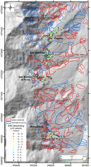
G. CIANFLONE, M. CONFORTI, S. SOLERI & F. IETTO

     In the all-time series a significative displacement (between 12.8
     and 5mm) was observed in the period 27/02/2005 – 08/05/2005
     coincident with the activation of the landslide on the march 7th
     2005 (Fig.11).
         Moving southward, in correspondence of Cerzeto village,
     which is not involved in landslide phenomena, the PS ERS
     descending (Fig. 8) showed almost null velocities (between 0.15
     and 1.75 mm/yr). More pixels of the Envisat ascending dataset
     highlighted as well a general stability (mean velocity between -0.9
     and 1 mm/yr) close to the village. A pixel with a velocity of about
     6 mm/yr was observed only near municipal hall.

                                                                                    Fig. 9 -    Envisat ascending LoS ground velocity maps; the dotted line
                                                                                                shows the study area (modified from Cianflone et al., 2018)

     Fig. 8 -   ERS descending LoS ground velocity maps for the study area

         In the San Giacomo village (fraction of the Cerzeto village)
     the PS ERS descending were characterized by velocities ranging
     from -0.9 to 1.6 mm/yr (Fig.8). Several Envisat ascending pixels,
     with a mean velocity between -1.8 and 0.5 mm/yr, were observed
     in the northern portion of the San Giacomo urban area (Fig. 10),
     located in a dormant complex landslide. Instead, in the middle part
     of the village, where no landslides were mapped, several pixels
     were identified, showing a decrease of mean velocity from western
     (-3.7 mm/yr) to eastern side (-0.6 mm/yr). Furthermore, heading                Fig. 10 - Zoom of the Envisat ascending LoS ground velocity maps for
     to south, close to the cemetery, two pixels with mean velocity                           the study area
     next to zero were recognized. The urban area of San Martino di
     Finita is also characterized by high slope velocities (up to 7.5 mm/           correspondence of this village, affected by two active landslides,
     yr) recorded by the PS ERS descending, while velocities around                 Envisat ascending pixels with velocities between -1.8 and -5.8 mm/
     zero were recorded only in the southernmost part of the village. In            yr (Fig. 10) were collected. Instead, in the area between the southern

28   Italian Journal of Engineering Geology and Environment, 1 (2021)   © Sapienza Università Editrice                                 www.ijege.uniroma1.it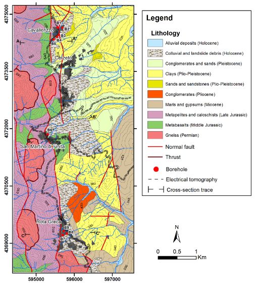
PRELIMINARY DATA ON SLOW-MOVING LANDSLIDES-AFFECTED URBAN AREAS THROUGH GEOLOGICAL, GEOMORPHOLOGICAL AND
INSAR ANALYSIS

Fig. 11 - Envisat ascending time series of Cavallerizzo, San Martino di Finita and Rota Greca villages

portion of the village and the cemetery, pixels with mean velocity              DISCUSSION
between -1.2 and -0.4 mm/yr were recognized. The analysis of                        During the 20th century, several landslide phenomena have
the Envisat ascending time series (Fig. 11), for the pixels inside              been recorded in the area extending from Cavallerizzo to Rota
landslide areas, shows the maximum displacement (about 50mm)                    Greca villages (Nossin, 1973; Carrara & Merenda, 1976;
in correspondence of pixel 1.                                                   Sorriso-Valvo et alii, 1996; Tansi et alii, 2016). The most serious
     Finally, in the Rota Greca village the PS ERS descending                   and dangerous instability event occurred on the march 7th 2005,
showed velocities ranging between -0.5 and 5 mm/yr (Fig. 8). In                 which caused severe damage to the southernmost part of the
the same area, we recognized the Envisat ascending pixels with the              Cavallerizzo (Fig. 5a and 5b). The whole Cavallerizzo urban area,
highest mean velocities of the whole study region (up to -6.4 mm/               as consequence, was abandoned and relocated in a new site for
yr). In detail, in the middle and southern portion of the urbanized             directive of National Civil Protection Department. Several authors
area, involved by large dormant landslides, several pixels with                 (Iovine et alii, 2006; Casagli et alii, 2006; Rizzo, 2005, 2008;
velocity between -0.08 and -6.4 mm/yr were identified, indicating               Gattinoni, 2009; Ietto, 2010) argued on different aspects about
active instability phenomena (Fig. 10).                                         the Cavallerizzo mass movement, such as: landslide modelling,
     For the Rota Greca village, the Envisat ascending time series              trigger-causes and state of activity. Furthermore, some authors
of pixels, located inside landslides, were also analyzed (Fig. 11).             (Iovine et alii, 2006; Rizzo, 2008) interpreted the cover of
The maximum displacement is showed by the pixel 9, currently                    metamorphic-crystalline fragments over the Neogenic sedimentary
situated inside a dormant landslide, where a rate of about 55mm                 deposits as the result of an ancient landslide. Rota Greca and San
was recorded. The analyzed time series shows a general irregular                Martino di Finita villages have also a long history of landslide
temporal evolution among the different pixels, anyway, common                   damage, as reported by city archives and by professional reports
periods of displacement acceleration were observed.                             (e.g. Tansi, 2010; Luci & Liguori, 2014).

Italian Journal of Engineering Geology and Environment, 1 (2021)    © Sapienza Università Editrice                             www.ijege.uniroma1.it   29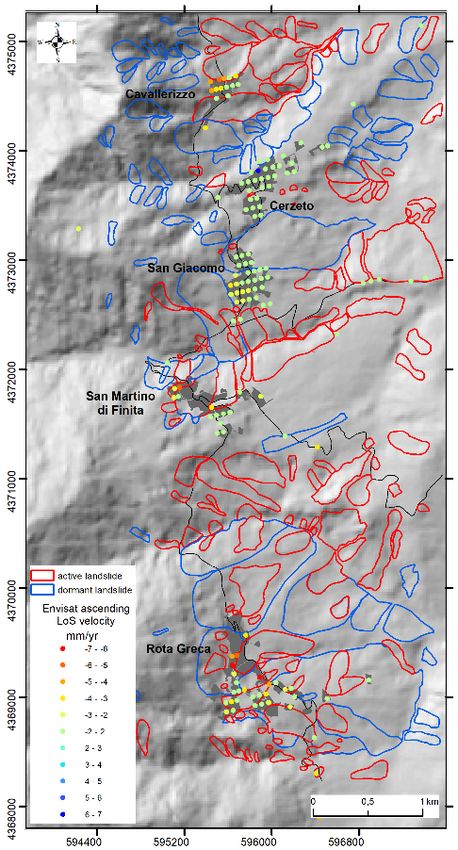
G. CIANFLONE, M. CONFORTI, S. SOLERI & F. IETTO

          The present research, with respect to the previous ones (Iovine           null velocities of ERS descending data and Envisat ascending data.
     et alii, 2006; Casagli et alii, 2006; Rizzo, 2008; Gattinoni,                  Instead, the western side of the middle urban area is characterized
     2009; Ietto, 2010), is based on a larger investigation area in                 by higher Envisat ascending velocities, which can be related to an
     order to acquire an overview of the instability processes affecting            instability state according to Casagli (2006).
     the area between Cavallerizzo and Rota Greca villages. At this                     In San Martino di Finita village, the analysis of the Envisat
     regard, new data obtained from geological and geomorphological                 ascending data confirm the urban area instability, with the
     investigations were integrated to the previous existing borehole               exception of the southernmost sector, where ERS descending data
     and geoelectric data, in order to determine a reliable underground             (1992-2000) show a constant stability condition since the 1990s.
     geological model.                                                              Finally, the Envisat analysis showed that widespread instability
          The obtained data showed that the colluvial deposit, composed             conditions, characterized by different velocities, involved the
     by crystalline-metamorphic fragments, characterizes the whole                  whole Rota Greca village both in the 1990s (ERS descending
     investigated hilly area and its thickness, ranging from minimum                data, velocities up to 5mm/yr) and in the 2000s (Envisat ascending
     10 m to maximum 64 m, is linked to the morphological variety of                data, velocities up to -6 mm/yr). Several Envisat pixels located
     the slopes. Indeed, higher thickness of colluvial material occur on            inside landslides, classified like dormant, showed movements
     gentle gradient slopes or in concave areas. The collected geological           with significative velocities, indicating a partial reactivation of
     data suggest that these slopes are prone to failures along definite            instability phenomena.
     surfaces located within the deposit or between its bottom and
     the top of clay layer. This assumption was also confirmed by the               CONCLUDING REMARKS
     deep displacement data obtained through the inclinometer placed                     In this work, geological and geomorphological surveys
     in Rota Greca village (Fig. 6). According to several authors (e.g.,            coupled to several geognostic investigations and InSAR data
     Hong & Wan, 2011; Sun et alii, 2019), the widespread instability               provided useful information to understand the instability
     phenomena are also favored by the great storage of groundwater,                processes affecting the area between Cavallerizzo and Rota Greca
     which, in the study area, is testified by an abundant presence of              villages.
     springs. This water storage is due to the tectonic contact between                  The data obtained by boreholes showed that a colluvial
     medium permeable and impermeable rock masses, corresponding                    deposit made up of metamorphic fragments in sand matrix, overlie
     to crystalline-metamorphic rocks and clay terranes respectively.               both the metamorphic-crystalline and the Neogene sedimentary
     Furthermore, most of landslides were recognized close to the San               terrains. This geological setting was also confirmed by the
     Fili-San Marco Argentano master fault. At this regard, several                 electrical resistivity tomography performed in San Martino di
     authors (Calcaterra & Parise, 2010; Borrelli & Gullà, 2017;                    Finita village. Abundant groundwater storage, due to the presence
     Conforti and Ietto, 2019) asserted that the fault cores along the              of brittle fault rock and by the tectonic contact between medium
     zones of maximum shear, where clay gouge and cataclastic rocks                 and low permeable rock masses, occurs close to the N-S tectonic
     occur, undergo a significant loss of their mechanical properties,              lineament, favoring the instability processes. This geological
     favouring slope instability. Therefore, terranes with poor                     setting dominates in the whole area between Cavallerizzo and
     mechanical properties and great storage of groundwater represent               Rota Greca villages.
     the main causes of the widespread mass movements in the studied                     The mass movements were mainly observed in the colluvial
     area.                                                                          deposits, where the urbanized areas are placed; anyway,
          In the Cavallerizzo village, the PS ERS descending (1992-                 several phenomena involve both the metamorphic-crystalline
     2000) recorded positive velocity values (target approaches the                 rocks and subordinately the Neogenic sedimentary deposits.
     sensor) that are also compatible with eastward displacements.                  Deep displacement data, obtained by an inclinometer placed
     Furthermore, widespread landslides in urban area were recognized               in Rota Greca village, revealed the presence of slide surfaces
     by Envisat ascending data collected in the period 2003-2010. All the           located between the bottom of colluvial deposit and the top of
     recognized pixels recorded negative velocity values (target moves              clay layer. Therefore, steep slopes, severe tectonic fracturing,
     away from the sensor), which can be related with a displacement                poor quality lithologies and abundant groundwater, drive the
     toward East, according to Casagli (2006).                                      widespread instability phenomena. A total of 225 landslides
          In Cerzeto village, the ERS descending (1992-2000) and the                were mapped in the studied area that expands on a surface of
     Envisat ascending (2003-2010) data show not significant velocities.            about 22 km2, giving rise to a landslide density of 10.2 landslide/
     The same result was achieved by Casagli (2006) through Radarsat                km2. Among the checked instability phenomena, the 64%
     data (2003-2005) analysis.                                                     was classified in active state and the remaining represent the
          Considering the northernmost part of the San Giacomo village,             dormant state. The slide-type landslides are the higher number
     the dormant state of landslide activity is demonstrated by the almost          equal to 183; instead, 36 and 6 are the instability phenomena

30   Italian Journal of Engineering Geology and Environment, 1 (2021)   © Sapienza Università Editrice                             www.ijege.uniroma1.it
PRELIMINARY DATA ON SLOW-MOVING LANDSLIDES-AFFECTED URBAN AREAS THROUGH GEOLOGICAL, GEOMORPHOLOGICAL AND
INSAR ANALYSIS
mapped as complex movements and flow-type respectively. distribution of landslides. Thus, a reliable modelling of the
Envisat datasets showed that the study area is well covered by landslide processes cannot be reached if one of the previous
data acquired along ascending orbit rather than descending one. aspects is excluded. Indeed, the whole of the achieved results
Envisat ascending velocities revealed values up to -6.5 mm/ supply suitable information about the understanding of the
yr for the landslides, testifying that all main urban centers are landscape evolution processes, providing a useful knowledge on
involved in active landslides. the assessment, prediction and reduction of the landslide hazard.
Concerning the InSAR monitoring of ground displacements
in the study area, future aim consists of the addition data from ACKNOWLEDGMENTS
the higher resolution and/or recent acquisition systems (e.g. This work was supported by the MIUR-ex 60% Project
COSMO-SkyMed and Sentinel-1 constellations). (Responsibility of Fabio Ietto). The authors are indebted to
The obtained results suggest that the set of lithological, anonymous reviewer for the comments and useful suggestions,
tectonic, geomorphological, hydrogeological and InSAR which were constructive for improving the quality of the
data provide valuable information for the study of cause and manuscript.
REFERENCES
Amodio-Morelli L,, Bonardi G., Colonna V., Dietrich D., Giunta G., Ippolito F., Liguori V., Lorenzoni S., Paglionico A., Perrone V., Piccar-
reta G., Russo M., Scandone P., Zanettin-Lorenzoni E & Zuppetta A. (1976) - L’Arco Calabro Peloritano nell’orogene Appenninico Maghrebide.
Memorie Società Geologica Italiana, 17: 1–60 (in italian).
Bartelletti C., Giannecchini R., D’amato Avanzi G., Galanti Y. & Mazzali A. (2017) - The influence of geological–morphological and land use set-
tings on shallow landslides in the Pogliaschina T. basin (northern Apennines, Italy). Journal of Maps, 13: 142–152.
Ben Avraham Z., Boccaletti M., Cello G., et al. (1990) - Principali domini strutturali originatisi dalla collisione neogenico-quaternaria nel Mediter-
raneo centrale. Memorie Società Geologica Italiana, 45: 453–462 (in italian).
Berardino P., Fornaro G., Lanari R. & Sansosti E. (2002) - A new algorithm for surface deformation monitoring based on small baseline differential
SAR interferograms. IEEE Transactions on Geoscience and Remote Sensing, 40: 2375–2383.
Bonardi G., Giunta G., Liguori V. et al. (1976) - Schema geologico dei Monti Peloritani. Bollettino della Società Geologica Italiana, 95: 49–74 (in ital-
ian).
Borrelli L., Conforti M. & Mercuri M. (2019) - Lidar and UAV system data to analyse recent morphological changes of a small drainage basin. ISPRS
International Journal of Geo-Information, 8: 536.
Borrelli L., Coniglio S., Critelli S. et al. (2016) - Weathering grade in granitoid rocks: the San Giovanni in Fiore area (Calabria, Italy). Journal of
Maps 12 (2): 260–275.
Borrelli L. & Gullà G. (2017) - Tectonic constraints on a deep-seated rock slide in weathered crystalline rocks. Geomorphology, 290: 288–316.
Calcaterra D. & Parise M. (2010) - Weathering as a predisposing factor to slope movements: an introduction. Geological Society, London, Engineering
Geology Special Publications, 23 (1): 1–4.
Capparelli G., Iaquinta P., Iovine G. et al. (2012) - Modelling the rainfall-induced mobilization of a large slope movement in northern Calabria. Natural
Hazards, 61: 247–256.
Carrara A. & Merenda L. (1976) - Landslide inventory in Northern Calabria, Southern Italy. Geological Society of America Bulletin, 87: 1153–1162.
Casagli N. (2006) - Analisi di dati telerilevati per l’emergenza connessa alla frana di Cerzeto (Cs) – Rapporto n. 5. Relazione tecnica per l’emergenza frana
in Cavallerizzo, pp.144 (in italian).
Casagli N., Colombo D., Corazza A. et al. (2006) - Use of remote sensing data for supporting landslide risk management: case history of Cavallerizzo,
Cosenza Province, Southern Italy. Geophysical Research Abstracts, 8: 6087-6087.
Cianflone G., Tolomei C., Brunori C.A. et al. (2015) - InSAR time series analysis of natural and anthropogenic coastal plain subsidence: the case of
Sibari (Southern Italy). Remote Sensing, 7: 16004–16023.
Cianflone G., Tolomei C., Brunori C.A. et al. (2018) - Landslides and Subsidence Assessment in the Crati Valley (Southern Italy) Using InSAR Data.
Geosciences, 8 (67).
Cigna F., Confuorto P., Novellino A. et al. (2016) - 25 Years Of Satellite Insar Monitoring Of Ground Instability And Coastal Geohazards In The
Archaeological Site Of Capo Colonna, Italy. In: Proceeding Spie Remote Sensing, Sar Image Analysis, Modeling, And Techniques Xvi, 100030Q,
Edinburgh, Uk 26-29 September.
Cigna F., Deodato T. & Lu Z. (2020) - Remote Sensing Of Volcanic Processes And Risk. Remote Sensing, 12: 2567.
Colella A., De Boer P. L. & Nio S.D. (1987) - Sedimentology Of A Marine Intermontane Pleistocene Gilbert‐Type Fan‐Delta Complex In The Crati Basin,
Italian Journal of Engineering Geology and Environment, 1 (2021) © Sapienza Università Editrice www.ijege.uniroma1.it 31G. CIANFLONE, M. CONFORTI, S. SOLERI & F. IETTO
Calabria, Southern Italy. Sedimentology, 34 (4): 721-736.
Conforti M. & Buttafuoco G. (2017) - Assessing Space-Time Variations Of Denudation Processes And Related Soil Loss From 1955 To 2016 In Southern
Italy (Calabria Region). Environmental Earth Sciences, 76 (13): 457.
Conforti M. & Ietto F. (2019) - An Integrated Approach To Investigate Slope Instability Affecting Infrastructures. Bulletin Of Engineering Geology And
The Environment, 78 (4): 2355–2375.
Conforti M. & Ietto F. (2020) - Influence Of Tectonics And Morphometric Features On The Landslide Distribution: A Case Study From The Mesima Basin
(Calabria, South Italy). Journal Of Earth Science, 31 (2): 393–409.
Conforti M., Pascale S., Robustelli G., et al. (2014) - Evaluation Of Prediction Capability Of The Artificial Neural Networks For Mapping Landslide
Susceptibility In The Turbolo River Catchment (Northern Calabria, Italy). Catena, 113: 236–250.
Costanzo S., Di Massa G., Costanzo A. et al. (2016) - Software-Defined Radar System For Landslides Monitoring. In: Rocha Á., Correia A., Adeli H.,
Reis L., Mendonça Teixeira M. (Eds) New Advances In Information Systems And Technologies. Advances In Intelligent Systems And Computing, Vol
445. Springer, Cham
Cruden D.M. & Varnes D.J. (1996) - Landslide Types And Processes. In: Turner, A. K., Schuster, R. L., Eds., Landslides: Investigation And Mitigation.
National Academy Press, Washington Dc.
Da Lio C. & Tosi L. (2018) - Land Subsidence In The Friuli Venezia Giulia Coastal Plain, Italy: 1992–2010 Results From Sar-Based Interferometry. Sci-
ence Of The Total Environment, 633: 752-764.
Diodato N., Soriano M., Bellocchi G. et al. (2017) - Historical Evolution Of Slope Instability In The Calore River Basin, Southern Italy. Geomorphol-
ogy, 282: 74–84.
Elmoulat M., Debauche O., Mahmoudi S. et al. (2020) - Computing And Artificial Intelligence For Landslides Monitoring. Procedia Computer Science,
177: 480-487.
Faccini F., Elter F.M., Alassia P. et al. (2019) - Geological-Geomorphological Characterisation And Monitoring Activities Of A Large Slope Instabilities
In Upper Graveglia Valley (Ligurian Apennine, Italy). Geophysical Research Abstracts, 21: 1-1.
Ferlisi S., Peduto D., Gullà G. et al. (2015) - The Use Of Dinsar Data For The Analysis Of Building Damage Induced By Slow-Moving Landslides. In:
Lollino G. Et Al. (Eds) Engineering Geology For Society And Territory, 2:1835-1839.
Ferretti A., Fumagalli A., Novalli F. et al. (2001) - A new algorithm for processing interferometric data-stacks: squeesar. IEEE Transactions on ge-
oscience and remote sensing, 49: 3460–3470.
Filice F., Liberi F., Cirillo D., Pandolfi L., Marroni M. & Piluso E. (2015) - Geology map of the central area of Catena Costiera: insights into the
tectono-metamorphic evolution of the Alpine belt in Northern Calabria. Journal of Maps, 11 (1): 114–125.
Gattinoni P. (2009) - Parametrical landslide modeling for the hydrogeological susceptibility assessment: from the Crati Valley to the Cavallerizzo landslide
(Southern Italy). Natural Hazards, 50: 161–178.
Guerricchio A. (1998) - Relazione geologica preliminare sulle indagini geognostiche da effettuare nell’area di pertinenza di un fabbricato IACP lesionato.
Relazione tecnica, Comune di Cerzeto (in italian).
Guerriero L., Confuorto P., Calcaterra D. et al. (2019) - PS-driven inventory of town-damaging landslides in the Benevento, Avellino and Salerno
Provinces, southern Italy. Journal of Maps, 15 (2): 619-625.
Hong Y.M. & Wan S. (2011) - Forecasting groundwater level fluctuations for rainfall-induced landslide. Natural Hazard, 57:167–184.
Ietto F. (2010) - Dati storici e dubbi sull’indotto della frana di Cavallerizzo di Cerzeto (Cosenza) del marzo 2005. Geologia dell’Ambiente, 3: 9-15.
Ietto F., Parise M., Ponte M. et al. (2012) - Geotechnical characterization and landslides in the weathered granitoids of Calabria (Southern Italy). Ren-
diconti Online Società Geologica Italiana, 21: 551–552.
Ietto F., Salvo F., Cantasano N. (2014) - The quality of life conditioning with reference to the local environmental management: a pattern in Bivona
country (Calabria, Southern Italy). Ocean and Coastal Management, 102: 340–349.
Ietto F. & Perri F. (2015) - Flash flood event (October 2010) in the Zinzolo catchment (Calabria, southern Italy). Rendiconti Online Società Geolocica
Italiana, 35: 170–173.
Ietto F. & Filomena L. (2015a) - Weathering processes in volcanic tuffrocks of the Rupe di Coroglio (Naples, southern Italy): erosion-rate estimation and
weathering forms. Rendiconti Online Società Geolocica Italiana, 33: 53–56.
Ietto F., Perri F. & Fortunato G. (2015b) - Lateral spreading phenomena and weathering processes from the Tropea area (Calabria, Southern Italy).
Environmental Earth Sciences, 73: 4595–4608.
Ietto F., Perri F. & Cella F. (2016) - Geotechnical and landslide aspects in weathered granitoid rock masses (Serre Massif, southern Calabria, Italy).
Catena, 145: 301–315.
Ietto F., Perri F. & Cella F. (2018) - Weathering Characterization for Landslides Modeling in Granitoid Rock Masses of the Capo Vaticano Promontory
(Calabria, Italy). Landslides, 15 (1): 43–62.
32 Italian Journal of Engineering Geology and Environment, 1 (2021) © Sapienza Università Editrice www.ijege.uniroma1.itPRELIMINARY DATA ON SLOW-MOVING LANDSLIDES-AFFECTED URBAN AREAS THROUGH GEOLOGICAL, GEOMORPHOLOGICAL AND
INSAR ANALYSIS
Iovine G., Petrucci O., Rizzo V. et al. (2006) - The March 7th 2005 Cavallerizzo (Cerzeto) landslide in Calabria - Southern Italy. In: Proceeding Geolo-
gical Society of London (in CD), Engineering geology for tomorrow’s cities. The 10th IAEG Congress, Nottingham, UK, 6-10 September.
Lanzafame G. & Tortorici L. (1981) - La tettonica recente nella Valle del fiume Crati (Calabria). Geografia Fisica a Dinamica Quaternaria, 4: 11-21 (in
italian).
Liberi F. & Piluso E. (2009) - Tectonometamorphic evolution of the ophiolitic sequences from Northern Calabrian Arc. Italian Journal Geoscience (Bollet-
tino Society Geological Italian), 128: 483–493.
Luci C. & Liguori F. (2014) – Piano d’indagini per gli interventi di Mitigazione del Rischio frana nel centro abitato e connessi interventi di sistemazione
idraulica del fosso Casale e corsi d’acqua minori. Relazione Tecnica, Comune di Rota Greca (in Italian).
Nossin J.J. (1973) - Use of air photos in studies of slopes stability in the Crati basin (Calabria, Italy). Geologia Applicata e Idrogeologia, 8: 261–287.
Perri F., Ietto F., Le Pera E. et al. (2016) - Weathering processes affecting granitoid profiles of Capo Vaticano (Calabria, Southern Italy) based on petro-
graphic, mineralogic and reaction path modeling approaches. Geological Journal, 51: 368–386.
Rizzo V. (2005) – Relazione del Sopralluogo Dissesto Idrogeologico Nel Comune di Cerzeto (Località Cavallerizzo) – secondo elaborato. Incarico Dipar-
timento Protezione Civile Nazionale. Protocollo n°. DPC/PRE/0013944 (in italian).
Rizzo V. (2008) – The landslide of Cavallerizzo (Cerzeto, Cosenza): alert criteria, aspect and issue. Rivista di Geologia Tecnica, 1: 5-33.
Sorriso-Valvo M., Tansi C. & Antronico L. (1996) - Relazioni tra frane, forme del rilievo e strutture tettoniche nella media Valle del Fiume Crati (Cala-
bria). Geografia Fisica e Dinamica Quaternaria, 19:107–117 (in italian).
Sun H.Y., Pan P., Lü Q. et al. (2019) - A case study of a rainfall-induced landslide involving weak interlayer and its treatment using the siphon drainage
method. Bulletin of Engineering Geology and the Environment, 78: 4063–4074.
Tansi C., Muto F., Critelli S. et al. (2007) - Neogene-Quaternary Strike-Slip Tectonics in the Central Calabrian Arc (Southern Italy). Journal of Geody-
namics, 43 (3): 393–414.
Tansi C. (2010) – Azioni di monitoraggio avanzato per la mitigazione del rischio idrogeologico nel commune di San Martino di Finita. Progetto A.M.A.Mi.R
Relazione Finale. pp 107.
Tansi C., Folino Gallo M., Muto F. et al. (2016) - Seismotectonics and landslides of the Crati Graben (Calabrian Arc, Southern Italy). Journal Maps,
12: 363–372.
Tortorici L., Monaco C., Tansi C. et al. (1995) - Recent and Active Tectonics in the Calabrian Arc (Southern Italy). Tectonophysics, 243 (1/2): 37–55.
Vai G.B. (1992) - Il segmento calabro-peloritano dell’orogene ercinico. Disaggregazione palinspastica. Bollettino Società Geologica Italiana, 111: 109–129
(in italian).
Zao C. & Lu Z. (2018) - Remote Sensing of Landslides—A Review. Remote Sensing, 10 (2): 279-284.
Received February 2021 - Accepted May 2021
Italian Journal of Engineering Geology and Environment, 1 (2021) © Sapienza Università Editrice www.ijege.uniroma1.it 33Puoi anche leggere