LANDSLIDE SUSCEPTIBILITY ASSESSMENT IN PYROCLASTIC SOILS: NUMERICAL ANALYSIS ON THE ROLE OF CAPILLARY BARRIERS - Italian ...
←
→
Trascrizione del contenuto della pagina
Se il tuo browser non visualizza correttamente la pagina, ti preghiamo di leggere il contenuto della pagina quaggiù
DOI: 10.4408/IJEGE.2021-01.S-20

           LANDSLIDE SUSCEPTIBILITY ASSESSMENT IN PYROCLASTIC SOILS:
             NUMERICAL ANALYSIS ON THE ROLE OF CAPILLARY BARRIERS

                Ciro SEPE(*,**), Domenico CALCATERRA(**), Diego DI MARTIRE(**),
      Massimo RAMONDINI(***), Giacomo RUSSO(**), Enza VITALE(**) & Lucia PAPPALARDO(****)

                 (*)
                       University of Cassino and Southern Lazio - Department of Civil and Mechanical Engineering - 03043 Cassino (FR, Italy)
              (**)
                     Federico II University of Naples - Department of Earth Sciences, Environment and Resources Sciences - 80126 Naples (Italy)
     (***)
           Federico II University of Naples - Department of Civil, Architectural and Environmental Engineering - Via Claudio, 21 - 80125 Naples (Italy)
         (****)
                Istituto Nazionale di Geofisica e Vulcanologia, Sezione di Napoli, Osservatorio Vesuviano - Via Diocleziano, 328 - 80124 Naples (Italy)
                                                             Corresponding author: ciro.sepe@unina.it

EXTENDED ABSTRACT
     Il lavoro riguarda lo studio dei fattori di innesco di fenomeni franosi a cinematica rapida che coinvolgono le coltri piroclastiche
di alcuni contesti geologici della Campania. Tali depositi sono essenzialmente da fall out e di origine prevalentemente vesuviana;
spesso in giacitura primaria, sono riferibili in particolare alle eruzioni avvenute circa 22.000 anni fa (Pomici di Base), 8.900 anni fa
(Pomici di Ottaviano) e 4.365 anni fa (Pomici di Avellino) e secondariamente alle eruzioni subpliniane del 472 d.C. (Pollena) e del
1631, separate in genere da paleosuoli spessi alcuni decimetri.
     In particolare l’area di studio, posta ai margini orientali della Piana Campana, ha interessato i versanti del territorio comunale
di Palma Campania, parte della più ampia dorsale carbonatica dei Monti di Sarno. Durante il rilevamento geologico sono state car-
tografate delle frane, relativamente recenti, con movimento iniziale del tipo scorrimento traslativo, la cui osservazione ha permesso
di comprendere che una delle cause in grado di determinare la rottura iniziale è dovuta alla possibile formazione di barriere capillari
durante eventi di pioggia, favorita dalla significativa variazione di porosità e di permeabilità fra livelli di pomici grigie e scorie
nere. Tale variabilità è stata pertanto indagata nel dettaglio, alla scala della microstruttura e del laboratorio. I depositi piroclastici
interessati sono depositi da fallout in giacitura primaria a diversa granulometria e grado di vescicolazione, che si possono attribuire
all’eruzione vesuviana delle cosiddette Pomici di Base datata circa 22 ka. Sono stati prelevati campioni a diverse altezze nella suc-
cessione stratigrafica per sottoporli ad analisi per la determinazione delle caratteristiche fisiche (granulometria, peso specifico e
densità) e caratteristiche tessiturali mediante microtomografia a raggi X, la quale ha consentito di determinare su campioni ricosti-
tuiti sia porosità sia conducibilità idraulica. Le analisi sperimentali hanno evidenziato quindi una variabilità lungo la successione
piroclastica esaminata di granulometria, peso specifico e densità dei materiali. I risultati ottenuti hanno supportato l’ipotesi di pos-
sibile formazione di barriere capillari al passaggio fra pomici grigie e scorie nere nel corso dei fenomeni di infiltrazione; tale ipotesi
è congruente con l’osservazione della posizione delle superfici di rottura delle frane osservate in campagna.
     L’ipotesi è stata sottoposta a verifica mediante simulazioni numeriche che hanno consentito di ricostruire il processo
d’infiltrazione dell’acqua meteorica ed il relativo avanzamento del fronte umido nei livelli stratigrafici al variare delle caratteris-
tiche tessiturali (granulometria, porosità, conducibilità idraulica). Per le simulazioni numeriche è stato considerato un modello alla
meso-scala (2D), utilizzando il software VS2DTI open source alle differenze finite sviluppato dall’U.S.G.S. per la simulazione di
processi di infiltrazione nei terreni parzialmente saturi. In particolare, nel caso di simulazioni con piogge di lunga durata e bassa
intensità (5mm/h), con terreni inizialmente caratterizzati da ridotti valori del contenuto d’acqua volumetrico, si è osservata una
lunga permanenza della barriera capillare (oltre 48 h), che favorisce l’accumulo di acqua negli strati più superficiali fino al rag-
giungimento di un elevato grado di saturazione (circa 85%) con conseguente diminuzione del livello di suzione, e con la conseg-
uente variazione della resistenza al taglio del materiale. In occasione di eventi di pioggia più intensi, a parità di condizioni iniziali
della coltre piroclastica, si è osservata la formazione della barriera capillare caratterizzata tuttavia da una permanenza limitata, e
conseguentemente un valore di grado di saturazione della coltre superficiale relativamente inferiore. Tale aspetto evidenzia come
questo fenomeno sia rilevante nel determinare le caratteristiche di stabilità della coltre superficiale, legate alla resistenza al taglio
in condizioni di parziale saturazione.
     Lo studio evidenzia l’importanza della caratterizzazione di dettaglio dei diversi livelli piroclastici coinvolti nella stabilità dei
pendii attraverso un approccio multidisciplinare. I risultati infatti mostrano come le discontinuità tessiturali possano influenzare i
fenomeni di infiltrazione e di conseguenza la stabilità delle coltri. L’approccio multidisciplinare, consentendo di aggiungere impor-
tanti informazioni per la caratterizzazione fisica dei materiali studiati, contribuisce all’affidabilità e alla robustezza dei modelli di
suscettibilità a franare delle coltri piroclastiche.

Italian Journal of Engineering Geology and Environment, 1 (2021)       © Sapienza Università Editrice                                 www.ijege.uniroma1.it   221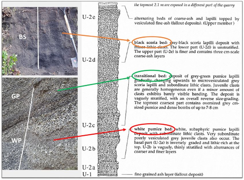
C. SEPE, D. CALCATERRA, D. DI MARTIRE, M. RAMONDINI, G. RUSSO, E. VITALE & L. PAPPALARDO

      ABSTRACT                                                                         of the areas potentially affected by further landslides, and to
           Landslides in pyroclastic soils are among the most calamitous               establish a critical value of rainfall for the temporary evacuation
      natural phenomena causing damage to people and territory                         of the population.
      every year. The mechanisms underpinning such landslides                              To achieve these goals, however, it is crucial to better
      can be controlled by multiple factors, including site conditions                 identify key factors triggering failure initiation and propagation,
      and features of pyroclastic soils. Spatial variations of textural                as they influence both the invasion areas, as well as the rainfall
      characteristics and related hydro-mechanical features in the                     threshold. Recent researches suggested that detachment
      overlain pyroclastic layers can yield to relevant effects on water               mechanisms of these rain-induced landslides can be controlled
      infiltration, with potential formation of capillary barriers at the              by different factors; nevertheless, a main feature has been
      interface between different soil layers.                                         assumed in the peculiar textural properties of the layered
           A better knowledge of the key triggering factors, based on                  pyroclastic soils (e.g. De Vita et alii, 2013; Cascini et alii,
      engineering-geological modeling, may be carried out through a                    2014; Urciuoli et alii, 2016; Damiano et alii, 2017). Abrupt
      detailed field and laboratory measurements, as well as performing                variations of textural characteristics (grain size, porosity,
      numerical simulations. The area surrounding Palma Campania                       permeability, etc.) among the pyroclastic levels can in fact
      (Napoli, Italy) is largely affected by fast-moving landslides                    determine a different water infiltration behavior and thus the
      involving pyroclastic deposits. The volcanoclastic sequence is                   development of capillary barriers (e.g. Shackelford et alii,
      constituted upward by (white and grey) vesicular pumices and                     1994; Khire et alii, 2000, Scarfone, 2020). Such phenomena,
      (black) dense scoriae levels, associated with the Somma-Vesuvius                 related to the capillary tension, limit the downward movement
      “Pomici di Base” Plinian eruption (22 ka). Stratigraphic sections                of the wetting front from a finer soil into underlying coarser
      along the carbonate slopes of Vallone Lupici reveal failure                      soils, thus leading to a localized increase in the water content
      surfaces along various pyroclastic contact layers (white/gray                    and loss of strength.
      vesicular pumice and dark dense scoria layers).                                      These processes have been tested through laboratory
           Representative samples were collected at different                          experiments in pyroclastic soils only at the macro-scale
      stratigraphic heights and analyzed to define structural and textural             (e.g. Mancarella et alii, 2012a, 2012b); thus, the complex
      characteristics; the obtained data were used as input parameters to              relationships between the intensity/duration of rainfall and
      perform 2D numerical simulations to explore the propagation of                   micro-textural features of the deposits in controlling the
      hydraulic front under different conditions of water flow (flow rate)             development and protracted actions of capillary barriers remain
      and textural features of rocks. The obtained results allow us to put             unclear. A major source of uncertainty is represented by the lack
      constrains on capillary barriers development in function of soils                of quantitative textural and geotechnical data, particularly at the
      characteristic and rain fall intensity.                                          micro-scale, directly measured on pyroclastic deposits. Many
                                                                                       modelling studies devoted to volcanic hazard assessment, in
      Keywords: pyroclastic soils, capillary barrier, numerical analysis,              fact, rely only on the generic use of available published data,
      landslide susceptibility                                                         often related to generic volcanic materials and conditions,
                                                                                       instead of the natural soils involved in the phenomena.
      INTRODUCTION                                                                         The case study the Vallone Lupici (Palma Campania),
           Landslides are among the most hazardous natural phenomena                   located in the Sarno Mts. ridge (Campania, Italy) has been
      causing worldwide damage to people and territory every year. In                  recently studied by Sepe (2019). A detailed field investigation has
      Campania region (Italy), slope instability represents a problem                  evidenced a series of confined landslides involving pyroclastic
      of great social impact, for both number of victims and damage                    deposits of Vesuvian origin. Particularly, field observations have
      caused to buildings, industries and infrastructures. Specifically,               evidenced the occurrence of failure surfaces in correspondence
      the instability of the pyroclastic deposits covering the                         of marked grain size and textural discontinuities. Consequently,
      Campanian carbonate slopes of the peri-Vesuvian area (Monti                      to explore at the micro-scale the conditions possibly favoring
      di Avella, Sarno and Lattari) represents one of the major factors                the development of efficient capillary barriers, samples of
      of risk as it generates rapid and long runout landslides, that were              pyroclastic soil at different stratigraphic depths were collected,
      responsible for great loss of properties and human lives. Thus in                in particular at the interface of the failure surface. Measurements
      the last decades, particularly following the high impact caused                  of micro-textural characteristics via X-ray computed
      by the tragic events of Sarno (5 and 6 May 1998 - 160 victims),                  microtomography on semi-undisturbed whole samples, as well
      it has received increasing attention in the scientific community                 as individual pyroclastic grains were performed.
      and government officials (Calcaterra et alii, 2003, 2004; Di                         In the paper the hypothesis of capillary barrier formation
      Martire et alii, 2012), with the aim to proper define the extent                 as relevant triggering factor of rapid landslides is considered.

222   Italian Journal of Engineering Geology and Environment, 1 (2021)     © Sapienza Università Editrice                             www.ijege.uniroma1.it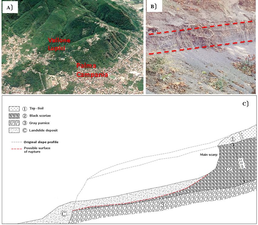
LANDSLIDE SUSCEPTIBILITY ASSESSMENT IN PYROCLASTIC SOILS: NUMERICAL ANALYSIS ON THE ROLE OF CAPILLARY BARRIER

Water infiltration simulations by finite-differences 2D                           low permeability barrier as long as it remains at low degree of
numerical model have carried out with reference to highly                         saturation. The infiltrating water is stored in the finer layer as a
reliable measured textural parameters of pyroclastic layers as                    consequence of capillary barrier effect. Increasing the amount
input data. Characteristic rainfall events have been considered                   of water stored in the finer layer (i.e. sustained heavy rainfall),
as hydrological input of numerical calculations. The obtained                     near the interface between the two layers suction decreases.
results highlighted the formation and persistence of capillary                    Equilibrium of the liquid phase implies that matric suction is
barriers at the interface between finer layer and coarser layer                   continuous across the interface between the two layers. Thus,
in the pyroclastic succession of Vallone Lupici. The study will                   as suction decreases at the bottom of the finer layer, it also
contribute to the understanding of the key factors controlling                    decreases at the top of the coarser layer, increasing its hydraulic
the detachment of rapid and long runout landslides and finally                    conductivity. Breakthrough of the capillary barrier occurs, and
to their susceptibility assessment.                                               water starts flowing from the finer layer to the coarser layer.
                                                                                  Bulk water forms a continuous liquid network in the coarser
WORKING                 PRINCIPLE                OF         CAPILLARY             layer and water flow starts downward (Stormont et alii 1999).
BARRIERS
    The working principle of capillary barriers is based on                       MATERIALS
the unsaturated properties of stratified layers. Differences                      Stratigraphy and representative sampling
between hydraulic properties (i.e., water retention, hydraulic                        The case study includes the municipal territory of
conductivity) of two soil layers of different grain size                          Palma Campania which is located in the “Conca Napoletana
distributions, namely an upper finer-grained layer overlying a                    (Neapolitan basin)” at the border of Nola and Sarno plains,
coarser-grained layer, can promote the formation of capillary                     delimited to the East by the Appennine Mesozoic limestone
barriers during an infiltration event. In saturated conditions,                   reliefs and to the West by the Somma-Vesuvius Quaternary
the hydraulic conductivity of the coarser layer is higher than                    volcanic complex (Fig. 3). A detailed field study allowed us to
that of the finer layer, whereas in unsaturated conditions                        identify a series of recent confined landslides, mainly located
the situation can be the opposite. In Figure 1 water retention                    in the “Vallone Lupici”, involving the Somma-Vesuvius
curves and hydraulic conductivity functions of fine grained and                   pyroclastic deposits (Fig. 2). They generally include few meters
coarse grained soils have been compared. For a generic suction
value A, the coarser layer is characterized by lower hydraulic
conductivity than the finer layer (kc,u(A)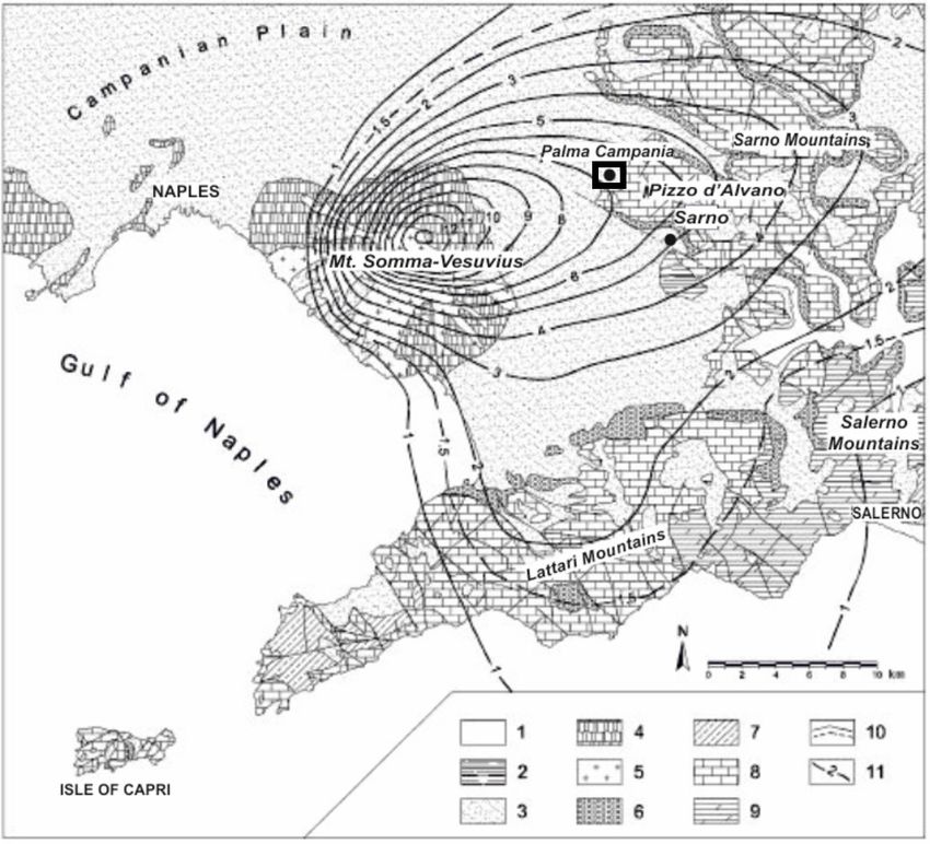
C. SEPE, D. CALCATERRA, D. DI MARTIRE, M. RAMONDINI, G. RUSSO, E. VITALE & L. PAPPALARDO
thick fallout deposit consisting, from the base to the top (Fig. 3), by using thin-walled tube samplers (Fig. 5). The collected
of a basal high-vesiculated white pumice layer, an intermediate samples were analyzed for the measurement of: 1) grain
level of high to moderate vesiculated gray pumices and an size distribution by sieving and specific gravity by water
upper level of denser dark scoriae; this stratigraphic sequence pycnometry; 2) density of single clasts by water pycnometry; 3)
(Fig. 4) corresponds to fallout deposits emplaced during the so microscopic quantification of both isolated and interconnected
called “Pomici di Base” Plinian eruption (22 ka, Santacroce porosity on reconstituted samples, as well as on single clasts,
et alii, 2008) of Somma-Vesuvius volcano, well described in through XRay computed microtomography (μXRCT). The
the literature (e.g. Bertagnini et alii 1998; Landi et alii 1999; obtained key textural parameters were used as input data
Pappalardo et alii, 2018; Buono et alii, 2020 a and b). for hydraulic conductivity and water infiltration numerical
simulations described in the following.
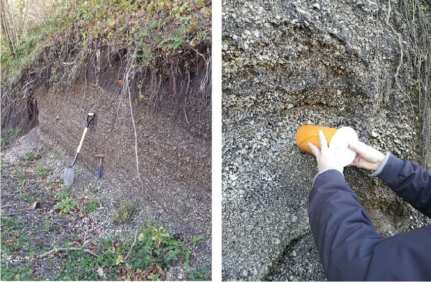
Fig. 5 - Vallone Lupici. Sampling of fallout deposit of Pomici di Base
Plinian eruption (22 ka)
Physical properties
Fig. 3 - A): 3D satellite image of the studied area (from Google
Earth); B) Detachment zone of the landslide (Vallone Lupici); Grain size distribution of pyroclastic samples vary along
C) Cross-section of a typical landslide the stratigraphic sequence. As reported in Fig. 6, according to
ASTM D422 black scoriae are formed by 80% sand and 20%
gravel, gray pumices by 80% gravel and 20% sand, and white
pumices by 70% gravel and 30% sand.
Density of solid phase varies between 27.2-28.2 kN/m3 for
black scoriae, whereas is between 25.9-27.3 kN/m3 for gray
pumices, and between 23.5-24.2 kN/m3 for white pumices.
Variations of solid density are in agreement with geochemical
changes described in literature (Bertagnini et alii, 1998),
from dense trachybasaltic-latitic scoriae of top layer to light
trachytic pumices at the bottom of volcanic succession.
Bulk density measurements, carried out on at least n.100
single clasts of each representative class (namely 2 mm, 5
mm and 10 mm), showed no significant variations within each
stratigraphic unit (Fig. 7). Bulk density increases from the
base to the top of stratigraphic succession, with lower modal
Fig. 4 - Vallone Lupici pyroclastic deposits: identification of Pomici values pertaining to basal withe pumices (modal value 5.9 kN/
di Base Plinian Eruption layers (BS: black scoriae, GP: m3, range 2.0-9.8 kN/m3), intermediate values to grey pumices
grey pumices, WP: withe pumices) and comparison with
stratigraphic sequence proposed by Bertagnini et alii (1988) (modal value 10.8 kN/m3, range 6.9–21.6 kN/m3) and higher
values to black scoriae (modal value 14.7 kN/m3, range 8.8–
Representative samples of coarse grained pumices were 23.5 kN/m3).
collected at different heights along the stratigraphic sequence As reported in Sepe (2019), total porosity of the layers,
224 Italian Journal of Engineering Geology and Environment, 1 (2021) © Sapienza Università Editrice www.ijege.uniroma1.it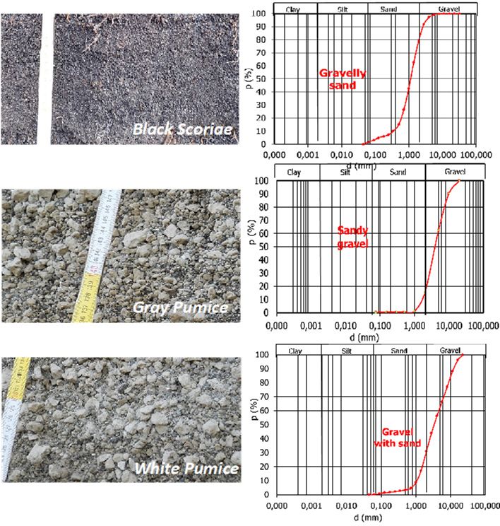
LANDSLIDE SUSCEPTIBILITY ASSESSMENT IN PYROCLASTIC SOILS: NUMERICAL ANALYSIS ON THE ROLE OF CAPILLARY BARRIER

                                                                                       The stratigraphic sequence in the numerical model has
                                                                                   been reproduced as showed in Fig. 8. Input parameters have
                                                                                   been derived from experimental data on the collected samples.
                                                                                   Porosity and saturated hydraulic conductivity of each layer were
                                                                                   derived by μXRCT data, as described in the previous section.
                                                                                   The intragranular porosity of pyroclastic deposits has not been
                                                                                   considered in the analyses. Volumetric water content has been
                                                                                   considered with reference to dry and wet conditions, in order
                                                                                   to verify its influence on capillary barrier formation. The water
                                                                                   retention properties of each layer have been implemented
                                                                                   with reference to Van Genuchten model, assuming as model
                                                                                   parameters data suggested by Mancarella et alii (2012),
                                                                                   De Vita et alii (2013), Pirone et alii (2014), Damiano et alii
                                                                                   (2017) for similar pyroclastic formations of the same region.

Fig. 6 -   Grain size distribution of the analyzed layers in stratigraphic
           succession

                                                                                   Fig. 8 -    The numerical column infiltration model (on the left)
                                                                                               reconstructed on the basis of the studied representative
                                                                                               stratigraphic succession: 1) basal white pumice layer with
                                                                                               a subordinate content in lithics, for a thickness of 1 m (in
                                                                                               yellow); 2) intermediate level of gray pumice and scoriae, for
                                                                                               a thickness of 0.5 m (in green); 3) upper level of black scoriae
                                                                                               and subordinate lithic clasts, for a thickness of 2.5 m (in red).
                                                                                               Input simulation parameters are shown on the right tables
                                                                                               (please see text for further explanations). A, B and C are the
                                                                                               observation points

                                                                                   The initial parameters considered in the numerical model have
                                                                                   been summarized in Tab. 1.
Fig. 7 -   Bulk density values of the analyzed samples in stratigraphic
           succession

evaluated from micro–Xray computed tomography results on
reconstituted samples, varied from the 43% in the basal layer
of white pumices to 36.5% in the grey pumices layer, down
to 33.8% for black scoriae layer. The hydraulic conductivity
associated to intergranular pore space was equal to k=8.9*10-2
                                                                                   Tab. 1 -    Numerical model: initial values of the relevant parameters
m/s for gray pumices and k=5.4*10-3 m/s for black scoriae.
                                                                                       Observation points were considered in the model for
WATER INFILTRATION SIMULATIONS                                                     analyzing time series of relevant variables (suction, water
    To test the hypothesis of capillary barrier formation at the                   content, flow velocity, etc.). Observation points (showed in Fig.
interface between black scoriae and gray pumices, a numerical                      8) were located immediately above (point A) and below (point
simulation of water infiltration process has been carried out by                   B) the interface between the upper finer layer and intermediate
using VS2DTI finite-difference numerical code (Lappala et alii,                    coarser layer, where capillary barrier is supposed to form, as
1987) for solving problems of variably saturated, single-phase                     well as at the bottom of the model (point C).
flow in porous media.                                                                  No flux has been allowed through the vertical boundaries of

Italian Journal of Engineering Geology and Environment, 1 (2021)       © Sapienza Università Editrice                                    www.ijege.uniroma1.it     225
C. SEPE, D. CALCATERRA, D. DI MARTIRE, M. RAMONDINI, G. RUSSO, E. VITALE & L. PAPPALARDO

      the model, whereas gravity drainage of the bottom side has been
      set. A 48h and 192h duration of infiltration process has been
      considered, with low-intensity (5 mm/h) and intense (50 mm/h)
      rainfall events.

                                                                                        Fig. 10 - Numerical model results: dry initial volumetric water content,
                                                                                                  long term duration, low intensity (0.6 mm/h) rainfall event

                                                                                        CONCLUSIONS
                                                                                             Investigations on landslides observed in the studied area
                                                                                        (Sarno Mountains in Campanian region, Italy) support the
                                                                                        hypothesis that porosity and permeability variations at the
                                                                                        interface between different pyroclastic levels can be a main
                                                                                        detachment factor of surface failure and propagation, due to
                                                                                        the saturation induced during a rainfall event induced by the
                                                                                        formation of capillary barriers.
                                                                                             The investigated deposit is a succession of fallout layers
                                                                                        of different grainsize and degree of vesiculation, attributed
                                                                                        to the so-called “Pomici di Base” Vesuvius plinian eruption
                                                                                        dated about 22 ka (Santacroce et alii, 2008). In detail it is
      Fig. 9 -   Numerical model results: dry initial volumetric water content,
                 a) 192h duration, low intensity (5 mm/h) rainfall event; b)            constituted from bottom to the top by a level of white pumice,
                 48h duration, intense (50 mm/h) rainfall event                         a transition level of gray pumice, an upper level of dark scoriae
                                                                                        (Bertagnini et alii 1998; Landi et alii 1999).
          The formation and persistence of a capillary barrier at the                        Detailed micro-textural analyses evidence a marked variation
      interface between the finer layer of black scoriae and the coarser                in the textural, geotechnical and hydraulic characteristics
      gray pumice layer was evidenced from the numerical results.                       among different pyroclastic layers according to the stratigraphic
      As showed in Fig. 9a, with reference to dry initial volumetric                    position, in particular at the interface between black scoriae
      water content (θ between 1% and 5%), for long lasting (192 h)                     and grey pumice layers, where landslides failure surfaces
      and low intensity (5 mm/h) rainfall events, the results show the                  are observed in the field. This finding support the hypothesis
      formation and persistence of capillary barrier for 30 hours. After                of development of capillary barriers at this interface during
      the breakthrough, the stationary condition is attained after 110 h                rainfall events, causing progressive saturation of the upper
      with degree of saturation of the finer layer Sr = 0.72 and of the                 layer and subsequent loss of stability. To test this hypothesis,
      coarser layer Sr = 0.11. For intense rainfall event (50 mm/h),                    water infiltration process in the pyroclastic layers sequence has
      the capillary barrier remains active for a short period (3 h), until              been simulated through a numerical model, selecting as input
      suction at the interface reaches the critical breaking value, as                  parameters textural and hydraulic characteristics measured on
      showed in Figure 9b. The stationary condition is attained when                    the collected samples.
      degree of saturation of the upper layer become relatively high                         The results allow to draw the following conclusions:
      (Sr = 0.85), while the degree of saturation of coarser layer is Sr =                   •    due to differences in textural and geotechnical features,
      0.19. For the lower intensity rainfall events (e.g. 0.6 mm/h), the                          capillary barrier forms at the interface of the black
      formation of capillary barrier is evidenced over the entire time                            scoriae and grey pumices layer if their initial volumetric
      interval considered (240h), as confirmed by constant degree of                              water content is reduced (dry condition);
      saturations of each layer underlying the interface (Fig. 10). No                       •    in dry initial conditions, the persistence of capillary
      capillary barrier formation has been observed for the considered                            barrier depends on the intensity of the rainfall event
      higher water contents reported in Tab. 1.                                                   (short persistence for intense rain and vice versa);

226   Italian Journal of Engineering Geology and Environment, 1 (2021)      © Sapienza Università Editrice                                 www.ijege.uniroma1.it
LANDSLIDE SUSCEPTIBILITY ASSESSMENT IN PYROCLASTIC SOILS: NUMERICAL ANALYSIS ON THE ROLE OF CAPILLARY BARRIER
• the persistence of capillary barrier regulates the final different pumice levels, evidencing the limits of considering the
saturation degree of the upper and lower layers, pumice levels as a homogeneous formation from geotechnical
influencing in turn their mechanical behaviour and point of view.
slope stability in general. This kind of multidisciplinary studies will contribute to
The study highlights the importance of detailed hazard assessment based on different geology-based parameters
characterization of different pyroclastic levels involved in slope (including textural features of pyroclastic levels), thus adding
stability through a multidisciplinary approach. The results advanced and complete information to the susceptibility models
show the role of textural and structural discontinuities between increasing in turn their reliability and robustness.
REFERENCES
Bertagnini A., Landi P., Rosi M., Vigliargio, A. (1998) - The Pomici di Base plinian eruption of Somma-Vesuvius. Journal of Volcanology and
Geothermal Research, 83 (3-4): 219-239.
Buono G., Pappalardo L. & Petrosino P. (2020a) - Magma storage and ascent during the largest eruption of Somma-Vesuvius volcano: Pomici di Base
(22 ka) Plinian event. Bollettino di Geofisica Teorica ed Applicata Vol. 61.
Buono G., Pappalardo L., Harris C., Edwards B.R. & Petrosino P. (2020b) - Magmatic stoping during the caldera-forming Pomici di Base eruption
(Somma-Vesuvius, Italy) as a fuel of eruption explosivity. Lithos, 370–371.
Calcaterra D., De Riso R. & Santo A. (2003) - Landslide hazard and risk mapping: experiences from Campania, Italy. Proc. Intern. Conf. On Fast Slope
Movements: Prediction and Prevention for Risk Mitigation, 1: 63-70. Naples: Patron Editore.
Cascini L., Sorbino G., Cuomo S. & Ferlisi S. (2014) - Seasonal effects of rainfall on the shallow pyroclastic deposits of the Campania region (southern
Italy). Landslides, 11 (5): 779-792.
Damiano E., Greco R., Guida A., Olivares L. & Picarelli L. (2017) - Investigation on rainwater infiltration into layered shallow covers in pyroclastic
soils and its effect on slope stability. Engineering Geology.
De Vita P., Napolitano E, Godt J.W. & Baum R.L. (2013) - Deterministic estimation of hydrological thresholds for shallow landslide initiation and slope
stability models: case study from the Somma-Vesuvius area of southern Italy. Landslides 10 (6): 713-728.
Di Martire D., De Rosa M., Pesce V., Santangelo M.A. & Calcaterra D. (2012) - Landslide hazard and land management in high-density urban areas
of Campania region, Italy. Nat. Hazards Earth Syst. Sci., 12: 905-926.
Khire M.V., Benson C.H. & Bosscher P.J. (2000) - Capillary barriers: design variables and water balance. J. Geotech. Geonviron. Eng., 126 (8): 695-
708.
Landi P., Bertagnini A. & Rosi M. (1999) - Chemical zoning and crystallization mechanisms in the magma chamber of the Pomici di Base plinian
eruption of Somma-Vesuvius (Italy). Contributions to Mineralogy and Petrology, 135: 179-197.
Lappala G., Healy R.W. & Weeks E.P. (1987) - Documentation of computer program VS2D to solve the equations of fluid flow in variably saturated
porous media. U.S. Geological Survey Water-Resources Investigations, Report 83: 4099.
Mancarella D. & Simeone V. (2012a) - Capillary barrier effects in unsaturated layered soils, with special reference to the pyroclastic veneer of the Pizzo
d’Alvano, Campania (Italy). Bull Eng Geol Environ, 71: 791-801.
Mancarella D., Doglioni A. & Simeone V. (2012b) - On capillary barrier effects and debris slide triggering in unsaturated layered covers. Engineering
geology, 147: 14-27.
Pappalardo L, Piochi M. & Mastrolorenzo G. (2004) - The 3550 YR BP - 1944 AD magma- plumbing system of Somma-Vesuvius: constraints on its
behavior and present state through a review of Sr-Nd isotope data. Annals of Geophysics, Vol. 47, n. 4: 1471-1483.
Pappalardo L. & Mastrolorenzo G. (2010) - Short residence times for alkaline Vesuvius magmas in a multi-depth supply system: Evidence from
geochemical and textural studies. Earth Planet Sci Lett, Doi: 10.1016/j-epsl.2010.05.010.
Pappalardo L., Buono G., Fanara S. & Petrosino P. (2018) - Combining textural and geochemical investigations to explore the dynamics of magma
ascent during Plinian eruptions: a Somma-Vesuvius volcano (Italy) case study. Contributions to Mineralogy and Petrology, 173: 61.
Pirone M., Papa R., Nicotera M.V. & Urciuoli G. (2014) - Evaluation of the hydraulic hysteresis of unsaturated pyroclastic soils by in situ measurements.
Procedia Earth and Planetary Science, 9: 163-170.
Santacroce R., Cioni R., Marianelli P., Sbrana A., Sulpizio R., Zanchetta G., Donahue D.J. & Joron J.L. (2008) - Age and whole rock–glass
compositions of proximal pyroclastics from the major explosive eruptions of Somma-Vesuvius: A review as a tool for distal tephrostratigraphy. Journal
of Volcanology and Geothermal Research, 177: 1–18. Sci., 12, 905-926.
Scarfone R. (2020) - Modelling the hydraulic behaviour of unsaturated soils and application to the numerical and experimental study of capillary barrier
systems. PhD thesis, University of Glasgow.
Italian Journal of Engineering Geology and Environment, 1 (2021) © Sapienza Università Editrice www.ijege.uniroma1.it 227C. SEPE, D. CALCATERRA, D. DI MARTIRE, M. RAMONDINI, G. RUSSO, E. VITALE & L. PAPPALARDO
Sepe C. (2019) - Landslide susceptibility assessment of pyroclastic deposits in pyroclastic deposits in Campania by modelling of triggering mechanisms.
PhD Thesis, University of Napoli Federico II, Italy.
Shackelford C.D., Chang C.K. & Chiu T.F. (1994) - The capillary barrier effect in unsaturated flow through soil barriers. In: Proceedings of the first
international congress on environmental geotechnics. Edmonton, Canada, July 10-15, 1994, 789-793.
Stormont J.C. & Anderson C.E. (1999) - Capillary barrier effect from underlying coarser soil layer. J. of Geotech. and Env. Engineering, 125 (8): 641-
648.
Urciuoli G., Pirone M., Comegna L. & Picarelli L. (2016) - Long-term investigations on the pore pressure regime in saturated and unsaturated sloping
soils. Engineering geology, 212: 98-119.
Received February 2021 - Accepted April 2021
228 Italian Journal of Engineering Geology and Environment, 1 (2021) © Sapienza Università Editrice www.ijege.uniroma1.itPuoi anche leggere