VISIONI DI UN FUTURO PIÙ VERDE PER IL SEIL DI AMMAN
←
→
Trascrizione del contenuto della pagina
Se il tuo browser non visualizza correttamente la pagina, ti preghiamo di leggere il contenuto della pagina quaggiù
AGATHÓN – International Journal of Architecture, Art and Design | n. 08 | 2020 | pp. 220-229
ARCHITECTURE                 ISSN print: 2464-9309 – ISSN online: 2532-683X | doi.org/10.19229/2464-9309/8212020

RESEARCH & EXPERIMENTATION

                             VISIONI DI UN FUTURO PIÙ VERDE
                             PER IL SEIL DI AMMAN
                             La Realtà Aumentata come strumento di progetto

                             VISIONS OF A GREENER FUTURE
                             FOR THE SEIL OF AMMAN
                             Augmented Reality as an urban design tool

                             Janset Shawash, Narmeen Marji

                             ABSTRACT
                             In un contesto caratterizzato dalle inondazioni e dal degrado ambientale del fiume Seil
                             di Amman (patrimonio naturale della capitale della Giordania), determinati dal cambia-
                             mento climatico, dalla rapida urbanizzazione e da una gestione non sostenibile dell’ac-
                             qua piovana, il contributo esplora le potenzialità delle nuove tecnologie del Mobile
                             Augmented Reality (MAR) quale strumento per ottenere un maggior coinvolgimento
                             dell’opinione pubblica in nuovi progetti di rigenerazione urbana ecologicamente soste-
                             nibili. Si presentano quindi due possibili scenari per un intervento a verde nell’area di
                             Ras al-Ein lungo il Seil, elaborati attraverso un software di realtà aumentata mobile im-
                             mersiva appositamente sviluppata, descrivendo sia il processo di sviluppo dell’applica-
                             zione sia la risposta degli utenti.

                             In a context characterized by flooding and environmental degradation of the Seil of
                             Amman (natural heritage of the capital of Jordan), caused by climate change, rapid
                             urbanization and unsustainable stormwater management, the paper explores the po-
                             tential of new Mobile Augmented Reality (MAR) technologies as a tool of public en-
                             gagement with new ecologically sustainable urban regeneration projects. Therefore,
                             two possible scenarios for a green/blue intervention in the Ras al-Ein area on the path
                             of the Seil are presented, elaborated through a specially developed immersive mobile
                             augmented reality software, describing both the application development process
                             and the users’ response.

                             KEYWORDS
                             contenimento delle inondazioni, infrastrutture verdi, realtà aumentata, Seil di Amman,
                             pianificazione partecipativa

                             flood mitigation, green infrastructure, augmented reality, Seil of Amman, participatory
                             planning

                             Janset Shawash, Architect and PhD, is an Assistant Professor at the School of Ar-
                             chitecture and Built Environment, German Jordanian University (Jordan). Her research
                             interests focus on history and theory of architecture, urban planning and design, es-
                             pecially issues relevant to localizing urbanism and promoting community involvement
                             in shaping their urban environment. Her professional expertise includes the planning
                             of major urban development projects in Jordan and the MENA region. Mob. +962
                             (0)77/73.39.433 | E-mail: Janset.shawash@gju.edu.jo

                             Narmeen Marji, Architect, specializing in Augmented Reality Development and cross-
                             platform application building for Architecture, Urban Planning and Design. She has
                             participated in projects of architectural design, city planning and heritage conservation
                             and is currently completing her Spatial Planning Master’s program focusing on appli-
                             cations of AR in architectural education at the School of Architecture and Built Envi-
                             ronment, German Jordanian University (Jordan). Mob. +962 (0)79/51.49.787 | E-mail:
                             narmeenm@gmail.com

220
Shawash J., Marji N. | AGATHÓN | n. 08 | 2020 | pp. 220-229

      Il Seil di Amman – il principale corso d’ac-        nire spazi verdi aperti, ridurre i consumi di acqua               Solo all’epoca del boom economico dei pri-
qua della capitale della Giordania – ha attratto          e di energia non rinnovabile e attivare una rige-            mi anni 2000, la rigenerazione urbana promos-
insediamenti umani fin dal Neolitico e ha pla-             nerazione urbana.                                            sa dallo Stato ha riportato all’attenzione l’area
smato lo sviluppo della città, lasciando nella                 Gli scenari proposti sono concettualizzati e            di Wadi Amman che è una estensione del Seil.
memoria degli abitanti di Amman il vivo ricordo           progettati schematicamente, costruiti come mo-               La memoria del Seil è allora riemersa, ispirando
di un paesaggio fertile e lussureggiante. A parti-        delli tridimensionali e poi presentati attraverso            con nostalgia romantica le proposte progettuali
re dal 1964, a causa della rapida espansione e            un’applicazione di realtà aumentata che utilizza             e la letteratura sulla città (Daher, 2013). Sebbe-
modernizzazione della città e della minaccia di           molteplici modalità di visualizzazione digitale e            ne il Masterplan del 2008 abbia incluso azioni di
inondazioni stagionali, lunghi tratti del fiume so-        permette a più utenti di ‘vivere’ la città e il Seil in      tutela dei corridoi del patrimonio naturale, la
no stati interrati in un canale sotterraneo sul           modi che prima non erano possibili. Un que-                  protezione del Seil è passata in secondo piano,
quale è stato realizzato un importante asse stra-         stionario semi-strutturato registra poi le reazioni          oscurata da nuove più urgenti e priorità (Gha-
dale, nonostante l’opposizione di numerose vo-            dei partecipanti e i feedback sugli scenari e sul-           raibeh, Al.Zu’bi and Abuhassan, 2019).
ci che chiedevano la sua rinascita come polmo-            l’applicazione. Complessità del progetto e stru-                  La questione del Seil è ritornata di attualità
ne verde della città congestionata e luogo di             menti innovativi impiegati rappresentano pur-                anche nel dibattito sulla pianificazione nel 2015
memoria storica e di appartenenza sociale.                troppo anche elementi di criticità della ricerca             a causa delle eccessive inondazioni che, ripe-
     Le recenti e violente inondazioni hanno ri-          per la mancanza di dettaglio delle proposte                  tutesi anche nel 2018 e nel 2019, hanno cau-
portato il Seil al centro del dibattito, attivando        progettuali e per il mancato coinvolgimento di               sato ingenti danni (The Jordan Times, 2019).
studi e soluzioni infrastrutturali spesso contra-         utenti non pratici nell’uso delle tecnologie digi-           Le frequenti inondazioni, dovute all’eccessi-
stanti che, nonostante la presenza di linee gui-          tali. Punti di forza tuttavia risiedono nella possi-         va urbanizzazione e ai cambiamenti climatici,
da sulla sostenibilità ambientale nell’ultimo Pia-        bilità di presentare originali e realistici ‘scenari         e la scarsa disponibilità d’acqua in Giordania
no di urbanizzazione della città, rimangono tra-          verdi’ per stimolare il dibattito pubblico, nello            (Jarrah, 2005) hanno attivato la ricerca inter-
dizionali e non sostenibili dal momento che so-           sviluppo e nella sperimentazione di applicazioni             nazionale e promosso diversi progetti; tra que-
no basate sulla manutenzione e sull’espansio-             mobili di realtà aumentata per la pianificazione              sti, la proposta ispiratrice di Qanat di trasfor-
ne delle infrastrutture in cemento. L’obiettivo prin-     urbana e nell’aprire la strada alla elaborazione             mare il centro di Amman in una rete di raccolta
cipale della ricerca che il presente contributo           di ulteriori ipotesi di rigenerazione dell’area.             idrica come parte della Urbanistica dell’Acqua,
illustra è quello di sviluppare uno strumento                                                                          avanzata dall’Amman Urban Design Studio
che permetta agli abitanti di Amman di visualiz-          Il Seil di Amman: contesto e storia | Il Seil di             della Columbia University nel 2017 (Columbia
zare potenziali scenari ‘verdi’ del Seil attraver-        Amman, che si estende per circa 6 km tra i di-               GSAPP, 2017), la ricerca Stream Daylighting
so le potenzialità offerte dalle tecnologie digitali      stretti di Ras al-Ein e Al-Mahatta, fa parte di un           condotta presso l’Università di Waterloo nel
in generale e dalla Realtà Aumentata in parti-            affluente che alimenta il secondo fiume più gran-              2015 (Khirfan, 2018) e numerose tesi di lau-
colare. L’esperimento pilota costituisce un pri-          de della Giordania, il Zarqa (Jarrah, 2005), ed è            rea in architettura.
mo passo mirato a ‘sfidare’ le proposte pre-              alimentato sia da sorgenti sia da acque piova-
sentate dalla Pubblica Amministrazione e a                ne prevalentemente nelle stagioni delle piogge.              Recupero dei fiumi urbani e pianificazione
piantare i semi di un cambiamento paradigma-              Il continuo prelievo di acqua dalle sue sorgenti             dei sistemi di gestione delle inondazioni:
tico nelle visioni e nelle aspettative che gli abi-       (Ababsa, 2014) ha prodotto nel tempo un dra-                 approcci e buone pratiche | Dall’analisi dei
tanti di Amman hanno per la loro città.                   stico abbassamento dei livelli delle falde acqui-            media e dalla revisione della letteratura sul Seil
                                                          fere e dello stesso Seil con conseguente sfrut-              emergono una serie di criticità: rischio di inon-
Metodologia: visioni per un futuro sostenibi-             tamento delle aree rimaste libere. Questo im-                dazione, degrado ambientale (qualità e quan-
le con l’uso della Realtà Aumentata | Coeren-             portante fiume è stato colonizzato fin dalla prei-             tità delle acque sotterranee), degrado del ver-
temente con la tendenza globale verso lo svilup-          storia e ha rappresentato un’arteria vitale per le           de urbano, perdita di una componente impor-
po di Smart Cities e la necessità di innovazione          civiltà autoctone fino all’età moderna, quando                tante del patrimonio naturale della città e crol-
digitale nel ‘new normal’ post-Covid-19, la ricer-        Amman è divenuta capitale del neonato Emira-                 lo dei valori immobiliari nelle aree soggette a
ca impiega la realtà aumentata come tecnologia            to di Transgiordania nel 1921. Il Seil irrigava ri-          inondazioni. Questi problemi non riguardano so-
abilitante dell’Industria 4.0 che può favorire nuo-       gogliosi spazi verdi ed era circondato da fer-               lo la Giordania poiché i Paesi di tutto il mondo
vi modi di vivere le nostre città e fornire nuovi         tili frutteti e spazi per il tempo libero all’aperto         soffrono degli effetti dell’aumento del cam-
strumenti per supportare decisioni ponderate              (Munif, 1996; Fig. 1); per questi motivi il fiume             biamento climatico e dell’urbanizzazione. Due
per uno sviluppo sostenibile. Lo studio sviluppa          è rimasto fortemente radicato nella memoria                  Obiettivi del Programma delle Nazioni Unite per
quindi un’applicazione di realtà aumentata mo-            collettiva come fonte di vita, di gioia e abbon-             lo Sviluppo Sostenibile (UN – General Assem-
bile costruita appositamente (Portman, Natapov            danza ma anche come fonte di pericolo per le                 bly, 2015) affrontano questi problemi e ispirano
and Fisher-Gewirtzman, 2015) per testare il coin-         inondazioni.                                                 la presente ricerca, in particolare, l’Obiettivo 11
volgimento degli utenti rispetto a due scenari vir-             Mentre Amman si espandeva, le inondazio-               – Città e Comunità Sostenibili e l’Obiettivo 13 –
tuali (Thompson, 2015). Gli scenari sono conce-           ni e l’inquinamento del Seil diventavano sem-                Azione per il Clima. A partire dagli anni ’80, la
piti sulla base di metodologie condivise, finaliz-         pre più problematici; così, nel 1964 l’Ammini-               necessità di una gestione sostenibile del dre-
zate a una visione prescrittiva e creativa, e su          strazione comunale ha deciso di regimentarne                 naggio urbano e del contenimento delle inon-
approcci strategici, basati sulla conoscenza ana-         le acque realizzando un canale di cemento e                  dazioni è emersa in diversi contesti; in risposta
litica del contesto e con il supporto di specifiche        un importante asse stradale per deconge-                     sono state quindi sviluppate soluzioni come i
discipline (Szpilko, 2020): il Seil di Amman viene        stionare il traffico veicolare, utilizzando i nuovi           sistemi di drenaggio urbano sostenibile, linee
esaminato attraverso i media e una revisione              terreni per usi culturali e pubblici dei quali una           guida per uno sviluppo a basso impatto, buo-
della letteratura sulle sue caratteristiche fisiche        capitale in crescita aveva bisogno (Gharaibeh,               ne pratiche di gestione, infrastrutture verdi e il
ed ecologiche nonché sul suo ruolo nel sistema            Al.Zu’bi and Abuhassan, 2019). Sebbene il                    Water Sensitive Urban Design (WSUD). Gli ap-
idrologico locale e sulla sua importanza storica e        Piano urbanistico del 1955 prevedesse aree a                 procci si differenziano per l’attenzione al ripri-
socio-culturale per la narrazione della città; ven-       verde e viali pedonali, relegando le zone di                 stino del deflusso delle acque al periodo pre-
gono altresì esaminati i Piani urbanistici che han-       espansione edilizia alle colline della città, poco           sviluppo, all’inquinamento, all’integrazione di di-
no previsto la sua canalizzazione e copertura, i          è stato realizzato in tal senso (Abu-Dayyeh,                 versi elementi paesaggistici e alla definizione di
recenti tentativi di riportarlo alla luce e il drastico   2004) mentre l’interramento del Seil è stato                 norme e linee guida nazionali (Benedict and Mc-
impatto delle recenti inondazioni sull’ambiente           percepito come un segno di modernità dell’e-                 Mahon, 2006; Fletcher et alii, 2015).
circostante. Come risultato la ricerca, supporta-         poca. I successivi Piani del 1978 e del 1987                       L’obiettivo dei sistemi di gestione sostenibi-
ta dall’analisi dello stato dell’arte di consolidati      sono stati redatti in periodi caratterizzati da              le delle acque piovane è quello di contenere le
approcci sostenibili, produce scenari preferibili         flussi migratori e crisi economica, eventi che                inondazioni, valorizzare le sorgenti idriche loca-
mirati a risolvere il problema delle inondazioni,         hanno assorbito l’attenzione dell’Amministra-                li, rendendole resilienti, facili da gestire ed ener-
migliorare l’equilibrio idrologico ed ecologico, for-     zione e hanno fatto dimenticare il Seil.                     geticamente sostenibili, e realizzare al contem-

                                                                                                                                                                       221
Shawash J., Marji N. | AGATHÓN | n. 08 | 2020 | pp. 220-229

                                                                                                                        Scenario 2 (2050) – Seil Amman Park (Fig.
                                                                                                                     4): il secondo scenario è un ambizioso proget-
                                                                                                                     to di lungo periodo che interessa le generazioni
                                                                                                                     future, segue i principi dei sistemi di drenaggio
                                                                                                                     sostenibili e si basa su approcci verde/blu con
                                                                                                                     l’obiettivo di rigenerare l’area Ras al-Ein Seil co-
                                                                                                                     me componente rinaturalizzata dell’ecosistema
                                                                                                                     Seil, demolendo in modo graduale parte dell’e-
                                                                                                                     dilizia e sostituendola con grandi bacini di de-
                                                                                                                     tenzione e di filtraggio delle acque e con rigo-
                                                                                                                     gliose aree ripariali e a verde attrezzato. La
                                                                                                                     maggior parte dei bacini alimenta le falde frea-
                                                                                                                     tiche e favorisce il raffrescamento dell’aria at-
                                                                                                                     traverso l’evaporazione. Nel centro congestio-
                                                                                                                     nato della città è previsto uno ampio spazio a
                                                                                                                     verde con giochi d’acqua per stimolare la rige-
                                                                                                                     nerazione dei quartieri circostanti. Il nodo stra-
                                                                                                                     dale all’estremità orientale dell’area viene man-
                                                                                                                     tenuto per consentire l’accesso degli utenti con
                                                                                                                     i mezzi pubblici.

                                                                                                                     Lo sviluppo della applicazione The Seil of
                                                                                                                     Amman AR mobile | I sistemi di realtà aumen-
Fig. 1 | An aerial view of the Seil of Amman in 1932 looking over the downtown and towards Ras al-Ein on the upper   tata (AR), che hanno già ottenuto un’ampia ap-
right (credit: American Colony, Photo Department, Photographer, 1932).                                               plicazione in campo militare e medico, nell’i-
                                                                                                                     struzione e nella conservazione del patrimonio
                                                                                                                     (Billinghurst et alii, 2015; Reaver, 2019), con-
po spazi naturali attraenti. Il sistema utilizza            mentare i valori immobiliari, ridurre i costi del-       sentono la visualizzazione, in uno spazio tridi-
componenti con funzioni diverse e agisce a dif-             l’approvvigionamento idrico ed energetico e im-          mensionale, di oggetti e informazioni reali e vir-
ferenti scale, comprendendo: le bioswales che               pedire eventuali danni derivabili da future inon-        tuali con cui gli utenti possono interagire in tem-
raccolgono e filtrano le acque superficiali; le               dazioni (Novotny, Ahern and Brown, 2010).                po reale (Redondo Domínguez et alii, 2017). I
pavimentazioni permeabili; le zone umide, for-                   Gli scenari implementano diverse misure a           requisiti hardware per i sistemi AR sono: 1) una
mate da depressioni in terreni che fungono da               seconda dell’approccio ‘verde/blu’ o ‘grigio’,           videocamera per catturare immagini dal vivo; 2)
bacini di contenimento dell’acqua piovana a                 utilizzando una combinazione di misure ‘grigie’          uno spazio di archiviazione degli oggetti virtuali;
sostegno di un’ecologia diversificata; habitat ri-           – come l’uso di canali di scolo e canalizzazioni         3) un potente processore per comporre oggetti
pariali che favoriscono il filtraggio degli inqui-           per agevolare la capacità di trasporto delle ac-         virtuali realistici e visualizzare un ambiente si-
nanti; bacini di contenimento che riducono i                que, l’uso di bacini coperti per il loro conteni-        mulato in 3D in tempo reale; 4) un’interfaccia
picchi di scarico nelle reti di drenaggio e pos-            mento e dighe con dispositivi di filtraggio e di          che permetta all’utente di interagire sia con gli
sono trattenere l’acqua per irrigare, in perio-             aerazione – e di misure ‘verdi’ come bacini a            oggetti reali che con quelli virtuali (Bower et alii,
di di siccità, il verde del paesaggio (Novotny,             cielo aperto, aree ripariali e paesaggistiche ma         2014). Le tecnologie presenti nei dispositivi mo-
Ahern and Brown, 2010; Alves et alii, 2020).                anche zone a uso collettivo per la socializza-           bili forniscono questi requisiti, in modo più ac-
D’altra parte gli interventi sostenibili richiedono         zione e lo svago (Alves et alii, 2020). Questo           cessibile ed economico rispetto agli AR Head-
importanti investimenti in infrastrutture, un coin-         approccio ‘verde’ viene sperimentato nell’area           Mounted Displays (HMD) sviluppati da diversi
volgimento della politica nella redazione di re-            di Ras al-Ein (Fig. 2) individuata come luogo ti-        produttori come Microsoft Hololens, Google
golamenti per l’implementazione di pratiche so-             po grazie alla sua posizione critica a monte del         Glass e Vuzix (Boulos et alii 2017).
stenibili e l’applicazione di programmi parteci-            centro città, alla prevalenza di terreni di pro-            In relazione ai requisiti software per i sistemi
pativi, tutte misure che richiedono quindi impe-            prietà comunale e all’alta percentuale di aree           AR mobili, si rileva che la maggior parte dei di-
gno e risorse finanziarie spesso assenti in con-             non edificate. Due gli scenari proposti che si           spositivi mobili in commercio utilizza uno dei
testi poco sviluppati (Guo, 2017).                          differenziano per la visione e gli approcci non-         due principali sistemi operativi, Android o iOS.
                                                            ché per l’estensione dell’intervento e gli obiet-        Per Apple iOS, l’uso delle funzionalità di ARKit
Costruire una visione: gli scenari | All’inter-             tivi prefissati.                                          (l’AR Software Development Kit di Apple) ri-
no di questo contesto culturale, la presente                   Scenario 1 (2030) – Progetto dei bacini di ac-        chiede un telefono o un tablet con un proces-
ricerca propone due scenari di rigenerazione                qua piovana Ras al-Ein (Fig. 3): il primo scena-         sore Apple A9 o successivo e una versione del
del Seil che si differenziano per portata, ap-              rio presenta una visione realistica e a breve ter-       sistema operativo non inferiore alla 11.0 (pre-
proccio e obiettivi, elaborati sulla base della             mine in un’area completamente edificata. Adot-            sente su iPhone SE, iPhone 6s e superiore),
morfologia e caratteristiche del sito, delle di-            ta misure di controllo delle acque piovane (No-          mentre per i dispositivi Android l’uso delle fun-
namiche delle inondazioni, dei requisiti infra-             votny, Ahern and Brown, 2010; Guo, 2017) e si            zionalità ARCore (la piattaforma AR di Google)
strutturali, delle esigenze e delle potenzialità            concentra sul contenimento del rischio di allu-          richiede almeno la versione 7.0 (API 24).
urbane. L’analisi delle esigenze e dei requisiti            vione nel centro di Amman, interrompendo il                 Per lo sviluppo della Seil of Amman AR Ap-
del caso studio ha individuato sette obiettivi              flusso delle acque piovane e trattenendole in             plication ci si è avvalsi della AR Foundation,
primari: 1) gestione delle acque piovane e                  serbatoi sotterranei nelle aree disponibili di pro-      che impiega sia ARCore che ARKit e supporta
contenimento delle inondazioni; 2) far rivivere             prietà comunale. La proposta si basa sull’im-            lo sviluppo di applicazioni AR per una vasta
la memoria del Seil e del suo patrimonio natu-              piego delle tradizionali infrastrutture grigie sotto     gamma di dispositivi. Il motore real-time utiliz-
rale; 3) offrire alla città uno spazio verde aper-          forma di serbatoi d’acqua coperti in cemento             zato per lo sviluppo della Seil of Amman MAR
to con bacini idrici pubblici; 4) offrire aree ri-          per captare parte del flusso di acqua piovana.            Application è Unity 3D in quanto consente uno
creative e parchi giochi; 5) migliorare la qua-             Si tratta di una soluzione più economica nel             sviluppo multipiattaforma (Android, iOS, Linux,
lità della vita degli abitanti di Amman; 6) mi-             breve periodo e la cui efficacia è condizionata          Windows, ecc.), utilizza un linguaggio di scrip-
gliorare l’equilibrio ecologico alimentando le              dalla quantità di acqua piovana, generata dai            ting per gli oggetti (C#) e offre una grande fles-
falde acquifere e la biodiversità e favorendo il            cambiamenti climatici, e dall’urbanizzazione. Inol-      sibilità nella personalizzazione delle interfacce
raffrescamento dell’aria; 7) attivare sviluppo e            tre non soddisfa gli obiettivi ecologici, sociali e      utente e una ricca libreria di risorse, materiali e
ripresa economica per le imprese locali, au-                di rigenerazione urbana discussi.                        texture gratuite.

222
Shawash J., Marji N. | AGATHÓN | n. 08 | 2020 | pp. 220-229
Funzionalità dell’applicazione ed esperien- vello di istruzione degli intervistati è risultato va- obiettivi del progetto descritti in precedenza
za AR offerta | La Seil of Amman MAR Appli- riabile: il 45% sono laureandi mentre il 52% è quelli che hanno ottenuto il punteggio più alto
cation è strutturata in 3 sezioni principali: un in possesso di una laurea; la maggioranza dei sono ‘offrire alla città spazi a verde e giochi
Audio-Visual Book introduttivo (Figg. 5, 6), un laureati (53%) si occupa di architettura e pia- d’acqua’, ‘contenere le inondazioni’ e ‘miglio-
AR Scenarios 3D Model (Figg. 7-9) e una se- nificazione urbana, ma è presente anche un rare la qualità della vita’. L’obiettivo che ha rac-
zione Sondaggio per raccogliere i feedback campione che lavora in altri settori (ingegneria colto il minor interesse è ‘fa rivivere la memoria
degli utenti. La sezione introduttiva dell’Audio- elettronica, medicina, ecologia, chimica e sto- del Seil’. Queste preferenze sono state confer-
Visual Book introduce l’utente al contesto del ria) e diversi pensionati. I dispositivi mobili utiliz- mate quando è stato chiesto agli intervistati di
progetto, alla sua storia, alle criticità e ai possi- zano i sistemi operativi iOS (79%) e Android selezionare un obiettivo di massima priorità e
bili scenari di rigenerazione dell’area. L’AR (21%), mentre i modelli degli smartphone più i citati obiettivi hanno ottenuto nell’ordine il
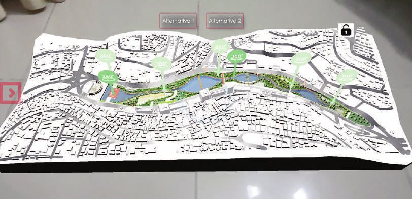
Scenarios 3D Model utilizza la funzionalità di ri- vecchi sono rispettivamente iPhone 7 e Sam- 40%, il 27,5% e il 15% di preferenze. Rispetto
levamento del framework dell’AR per creare sung Galaxy S8+. poi allo scenario preferito, la maggioranza (75%)
un’esperienza in realtà aumentata senza marker. Dal sondaggio è poi emerso che tra i sette ha indicato quello che prevede la realizzazione
Quando il dispositivo mobile rileva una super-
ficie orizzontale, l’utente può avviare l’espe-
rienza AR e generare il modello 3D virtuale del
progetto. Il modello interattivo include pulsanti
AR che possono essere attivati attraverso il
touch screen del dispositivo mobile. La scena
AR ha poi due tab principali: la Views a 360
gradi che consente la visualizzazione di imma-
gini renderizzate delle aree chiave del model-
lo (Figg. 10, 11) e la Information che sblocca i
diversi livelli interattivi tramite i pulsanti della
Unity’s User Interface.
I modelli 3D dei possibili scenari sono stati
ottimizzati ed esportati dal software Autodesk
Revit con numero minimo di poligoni e poi im-
portati in Unity per aggiungere materiali con
texture compresse al fine di preservare le pre-
stazioni dei dispositivi mobili ed evitare il surri-
scaldamento dovuto al sovraccarico della CPU
nel calcolo e nell’elaborazione delle immagini.
L’ultima sezione dell’applicazione è il link a una
pagina online che consente di compilare un
questionario, creato con Google Forms, per
raccogliere i feedback degli utenti su quattro
argomenti principali: le caratteristiche degli in-
tervistati, il gradimento degli scenari di svilup-
po, la funzionalità dell’applicazione e la facilità
d’uso della tecnologia AR. Le domande sono
strutturate con selezione delle categorie men-
tre le risposte, misurabili attraverso la scala
Likert, sono del tipo aperte e a scelta multipla.
Sperimentazione dell’applicazione MAR |
L’applicazione è stata resa disponibile online
per entrambe le piattaforme iOS e Android
(Fig. 13), pubblicizzata sui social-media per
una settimana nel settembre 2020 e ulterior-
mente diffusa tramite il passaparola. Un cam-
pione di 40 intervistati, le cui risposte sono di-
sponibili online (Fig. 13), ha partecipato alla va-
lutazione dell’applicazione: il campione è com-
posto per l’80% da donne e per il 20% da uo-
mini mentre la maggioranza degli intervistati
(37,5%) è compresa nella fascia d’età tra i 35 e
i 44 anni (Fig. 14). I più anziani, che non sono
apparsi reattivi durante le prime fasi del son-
daggio, sono stati assistiti nell’uso dell’applica-
zione poiché la loro partecipazione al sondag-
gio è stata ritenuta importante anche in relazio-
ne alla conoscenza che hanno della città. Il li-
Fig. 2 | The current context of Ras al-Ein area (credit:
edited GoogleEarth, 2020).
Fig. 3 | Masterplan for Scenario 1 (2030) – Ras al-Ein
Stormwater Reservoirs Project.
Fig. 4 | Masterplan for Scenario 2 (2050) – Seil Am-
man Park.
223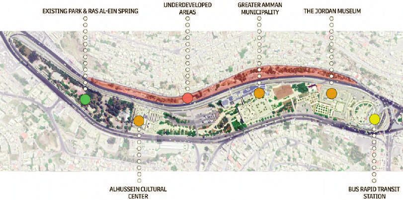
Shawash J., Marji N. | AGATHÓN | n. 08 | 2020 | pp. 220-229

Figg. 5, 6 | Pages from The Seil’s History Audio-Visual Book section: View of the floods; Stormwater management approaches.

del Seil Amman Park, mentre il 7,5% ha sug-                  si traducono in una maggiore difficoltà nella ri-             back into the news, resulting in conflicting stud-
gerito un terzo scenario come combinazione                   produzione del modello.                                      ies and infrastructural remedies. Despite the
dei due proposti (Fig. 14). Le maggiori criticità               La maggior parte degli intervistati ha votato             environmentally sustainable guidelines laid out
rilevate dagli intervistati per l’attuazione del             lo scenario più sostenibile del Seil Park e ha               in the latest Masterplan for the city, the imme-
progetto sono state classificate come: 1) ‘bas-               mostrato una predisposizione verso simili pro-               diate solutions remain traditional and unsus-
sa priorità per soluzioni urbane orientate all’e-            getti di sviluppo della città, esplicitando così il          tainable in their nature, relying on maintenance
cologia’ e ‘mancanza di supporto dei legisla-                bisogno di spazi verdi in città e di contenere               and expansion of grey infrastructure. Visioning
tori’; 2) ‘costo’; 3) ‘manutenzione e sostenibi-             gli effetti dannosi delle inondazioni. Gli intervi-          change remains a challenge. The main goal of
lità del progetto’.                                          stati più anziani hanno scelto lo scenario più               this research is to develop a tool to facilitate
    In relazione all’applicazione, la maggioranza            realistico a causa delle preoccupazioni sui co-              the presentation of alternative green visions for
degli utenti (92%) riferisce di essere soddisfatta,          sti e hanno suggerito un approccio graduale                  the Seil to the people of Amman, by immersing
mentre i problemi segnalati riguardano la fun-               per l’attuazione del progetto. Il feedback quali-            them in digital 3D representations of conceptu-
zionalità dei componenti, il surriscaldamento                tativo del sondaggio ha mostrato che gli inter-              al masterplans using innovative Augmented Re-
del dispositivo, le difficoltà di installazione del-          vistati desidererebbero comunque un cambia-                  ality technologies. This pilot experiment forms a
l’applicazione e la trasferibilità del progetto e            mento nella città, avendo visto soluzioni alter-             first step in challenging the status quo of munic-
del layout tra diversi formati di immagine. Il 60%           native e realizzabili.                                       ipal practices and planting the seeds of a paradig-
degli intervistati dichiara che l’applicazione è fa-            Dopo aver esplorato le potenzialità delle ap-             matic shift in the visions and expectations that
cile da usare (con un punteggio di 4 e 5 su sca-             plicazioni MAR e la prima reazione degli intervi-            the people of Amman have for their city.
la Likert). Le componenti dell’applicazione giu-             stati in questo studio pilota, la ricerca apre ul-
dicate più piacevoli sono la vista a 360 gradi e             teriori spazi di esplorazione: seguiranno uno                Methodology: visions for a sustainable fu-
la realtà aumentata, raggiungendo rispettiva-                studio più approfondito degli aspetti tecnici                ture using Augmented Reality | Given the glob-
mente il 60% e il 50% di gradimento degli uten-              delle proposte e discussioni più approfondite                al move towards Smart Cities and the recon-
ti. Nel complesso l’esperienza dell’applicazione             con il Comune e gli stakeholders. Il feedback                firmed need for digital innovation in the post-
è stata giudicata positiva e il 75% degli intervi-           sulla funzionalità dell’applicazione incentiva an-           Covid-19 New Normal, the research employs
stati riferisce che migliora la percezione degli             che lo sviluppo di uno strumento più coinvol-                augmented reality as a component of enabling
scenari proposti. Il 95% degli intervistati con-             gente e accessibile. Il successo di questo pro-              technologies of Industry 4.0 that can offer new
corda che utilizzerebbe tale applicazione per va-            getto pilota visionario potrebbe quindi aprire la            ways of experiencing our cities and making in-
lutare gli scenari futuri della città.                       strada a potenziali realtà più verdi e più inclusi-          formed decisions for sustainable future devel-
                                                             ve per la città di Amman.                                    opment. This research develops a purpose-built
Conclusioni | I risultati del sondaggio mostra-                                                                           mobile augmented reality application (Portman,
no che l’utilizzo di un’applicazione AR per valu-                                                                         Natapov and Fisher-Gewirtzman, 2015) – a rel-
tare potenziali progetti di sviluppo e rigenera-                                                                          atively new tool with a promising future and a
zione urbana è gradita e che può essere uno                  The Seil of Amman – the main water stream of                 still minimal application in urban design, and as
strumento di partecipazione pubblica e di voto.              the capital of Jordan – has attracted human                  part of a bigger research project – to initiate
L’uso di modelli 3D immersivi ha semplificato le              settlers since the Neolithic Age and shaped                  and test public engagement, and visualize two
componenti complesse per utenti non esperti                  the development of the city, holding a vibrant               original realistic scenarios as props for feed-
di età diverse, soprattutto per le fasce d’età               memory of lush greenery and fertile landscape                back (Thompson, 2015).
più avanzate. La ricerca ha rivelato un gap ge-              in the psyche of the Ammanis. However, as                          The scenarios are conceived based on fore-
nerazionale nell’utilizzo di dispositivi mobili: in-         the case in numerous modernizing cities in the               sight methodologies, by producing prescriptive
fatti, l’applicazione è stata ritenuta relativamen-          world, and due to threats of seasonal flooding,               and creative visioning, and strategic scenario
te facile da usare per gli intervistati di età infe-         the Seil was entombed in a culvert under a                   building, through an analytical overview and un-
riore ai 45 anni, mentre le generazioni più an-              major road starting 1964. Due to the extraordi-              derstanding of the context and required disci-
ziane hanno richiesto assistenza e una breve                 nary fast growth rate of the city and competing              plines (Szpilko, 2020): the Seil of Amman is ex-
spiegazione del progetto e della tecnologia AR.              priorities, longer stretches of the dwindling wa-            amined by performing a media analysis and lit-
In termini di utilizzo dei dispositivi mobili, è sta-        ter stream were covered, despite the opposi-                 erature review focusing on its physical and
ta osservata una prevalenza di utenti iOS; è                 tion of numerous voices calling for the revival              ecological attributes and significance to the hy-
emerso anche che questi dispositivi hanno una                of this crucial natural component as a green                 drological system; its historical and socio-cul-
fluidità d’immagine maggiore quando si ese-                   space in the congested city and a place of so-               tural importance to the narrative of the city; the
guono le scene AR sebbene siano più sensibili                cial memory and belonging.                                   visions that sequential masterplans for the city
alla luce e al rilevamento del piano, fattori che                 Recent extreme floods brought the Seil                  had on the canalization and roofing of the Seil,

224
Shawash J., Marji N. | AGATHÓN | n. 08 | 2020 | pp. 220-229

and contemporary attempts to bring it back;               leaving the streambeds as green fingers and                 ry of the Seil emerged again, as a romantic
as well as the drastic impact of recent floods             parkways while limiting urban build-up zones to            nostalgia guiding design proposals and litera-
on its surroundings. The research then pro-               the hilltops of the city, this goal did not material-      ture on the urban realm (Daher, 2013). Al-
ceeds to derive a future vision from the state of         ize (Abu-Dayyeh, 2004), and the roofing of the              though the Masterplan for the city of Amman
the art analysis of sustainable approaches, with          Seil was seen at the time as a herald of moder-            for the year 2008 reinforced the concept of the
the priorities of resolving flooding, improving the        nity. Subsequent masterplans of 1978 and 1987              protection of natural heritage corridors, these
hydrological and ecological balance, providing            came at times of influx of refugees and eco-                concepts remain weakly developed, and the
green open space, reducing water and energy               nomic crisis; the concern was to provide for a             protection of the Seil was overshadowed by
bills, and activating urban regeneration.                 well-functioning city, and the Seil was forgotten.         more pressing priorities (Gharaibeh, Al.Zu’bi
     The proposed scenarios are conceptualized                It was only at the time of economic boom               and Abuhassan, 2019).
and schematically designed, built as 3D mod-              of the early 2000s that State led urban regen-                 The Seil re-emerged in public and planning
els, then presented through an AR application,            eration brought the area of Wadi Amman – the               discourses in 2015 as a result of excessive
which uses multiple digital modes of visualiza-           extension of the Seil – to attention. The memo-            flooding, which recurred in 2018 and 2019 caus-
tion, and allows multiple stakeholders to expe-
rience the city and its Seil in ways that were
not possible before. A semi-structured ques-
tionnaire registers the participants’ reactions
and feedback regarding the scenarios and the
AR application. The novelty and cross-disci-
plinarity of this research project pose limita-
tions in terms of the detail of design proposals,
extent of public engagement and exclusion of
groups not accustomed to the use of digital
technologies. Its significance lies, however, in
presenting original green visions for public dis-
course, developing and testing mobile aug-
mented reality application for urban design,
and paving the road for further research.

Seil of Amman: context and history | The Seil
of Amman, conventionally known to stretch
approximately 6 km between the districts of
Ras al-Ein and Al-Mahatta, forms part of a
tributary feeding second largest river in Jor-
dan – Zarqa River (Jarrah, 2005). The Seil draws
its water from fresh springs in addition to
stormwater in rainy seasons. Heavy water ex-
traction from its springs (Ababsa, 2014) led to a
dramatic drop in groundwater levels and in-
creased drying out of the Seil. The Seil of Am-
man has been settled since prehistoric times
and continued to be a lifeline of civilizations well
into the modern ages, as Amman re-emerged
as the capital of the newly formed Emirate of
Transjordan in 1921. The Seil nurtured vibrant
green spaces and was surrounded by fertile or-
chards, spaces for picnics, and barbeque restau-
rants (Munif, 1996; Fig. 1). This strongly rooted
it in the social psyche as the dynamic water
stream of Amman, its source of joy and abun-
dance, but also the danger of the flood.
     As Amman transformed into a city, the Seil’s
flooding and pollution became more problemat-
ic. The Municipality of Amman decided in 1964
to entomb it in a concrete culvert that would
serve as a main road to alleviate traffic conges-
tion and claim new land for cultural and munici-
pal purposes suitable for a growing capital
(Gharaibeh, Al.Zu’bi and Abuhassan, 2019). Al-
though the City Masterplan of 1955 suggested

Fig. 7 | Screenshot from The Seil of Amman AR Appli-
cation – AR 3D Model for the second scenario with the
360 views tab activated.
Fig. 8 | Screenshot from The Seil of Amman AR Applica-
tion – AR 3D Model for the second scenario with the in-
formation tab activated and the ‘Riparian Areas’ layer
selected.
Fig. 9 | Zooming into the AR 3D Model for the second
scenario.

                                                                                                                                                                  225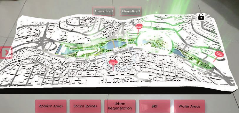
Shawash J., Marji N. | AGATHÓN | n. 08 | 2020 | pp. 220-229

226
Shawash J., Marji N. | AGATHÓN | n. 08 | 2020 | pp. 220-229

ing damages to real estate and properties (The           of pollutants; detention basins that reduce peak        eas between the existing Municipal and Cultur-
Jordan Times, 2019). Frequent flooding due to             discharge into drainage networks, and could             al buildings in Ras al-Ein area. This proposal
high urbanization and climate change coupled             be designed to either retain water permanently          relies on traditional grey infrastructure in the form
with the severe water scarcity in Jordan (Jar-           to support green landscape elements, dry as             of covered concrete water tanks, which would
rah, 2005) inspired international research and           part of a hardscape composition, or concealed           capture part of the stormwater overflow. This
urban design projects, such as: the inspira-             under other urban elements (Novotny, Ahern              proposal offers a cheaper solution for a shorter
tional Qanat proposal to turn downtown Am-               and Brown, 2010; Alves et alii, 2020). On the           period, as its sustainability would depend on
man into a water harvesting network as part              other hand, sustainable interventions require a         the increasing stormwater quantities due to cli-
of the 2017 Water Urbanism – Amman Urban                 major investment in infrastructure, political sup-      mate change and urban intensification. It also
Design Studio at Columbia University (Colum-             port to enable regulations for the implementa-          does not satisfy the ecological, social or regen-
bia GSAPP, 2017); Stream Daylighting re-                 tion of sustainable practices, and application of       eration objectives above.
search conducted at the University of Waterloo           participatory programs. These measures re-                   Scenario 2 (2050) – Seil Amman Park (Fig.
in 2015 (Khirfan et alii, 2020); and numerous            quire dedication and financial resources that            4): the second scenario is an ambitious gener-
architectural graduation projects.                       could be lacking in underdeveloped contexts             ational project, which follows the principles of
                                                         (Guo, 2017).                                            Sustainable Drainage Systems (SuDS) and re-
Restoring urban rivers and planning flood                                                                        lies on green/blue approaches with the vision
management systems: approaches and best                  Building a vision: masterplan scenarios | This          to bring back the Ras al-Ein Seil area as a re-
practices | According to media analysis and              research proposes two masterplan scenarios              naturalized component of the Seil eco-system.
literature review, the problems associated with          as props for public engagement, differing in            It aims to return the area to its natural state by
the current condition of the Seil could be               their scope, approach and objectives; while             the phased relocation of major buildings and
summed as: flood risk, degradation of environ-            considering site morphology and characteris-            replacing them with large detention and infiltra-
mental quality (quality and quantity of ground-          tics, flood dynamics, infrastructure requirements,       tion basins with rich riparian zones and com-
water), degradation of the quality of green ur-          and urban needs and potentials. Media analy-            munal areas. The detention basins would pro-
ban space, disappearance of an important                 sis of the case study’s needs and require-              vide space for the temporary storage of high-
component of the natural heritage of the city,           ments identified seven primary objectives: 1)            event stormwater and year-round water ponds
and degradation of real-estate values in flood-           Stormwater management and flood mitigation;              to support the riparian landscapes. The larger
prone areas. These problems are not unique               2) Reviving the memory of the Seil and its nat-         percentage of the ponds would be pervious to
to Jordan, as countries worldwide suffer from            ural heritage; 3) Offering green open space to          allow groundwater recharge and air cooling
the effects of increased climate change and              the city, that would contain public water fea-          through evaporation. An attractive green space
urbanization. Two Sustainable Development                tures; 4) Offering recreational areas and play-         with much-needed water features in the con-
Goals 2030 (UN – General Assembly, 2015) ad-             grounds; 5) Improving the quality of life for the       gested heart of the city is envisioned to kick-
dress these issues and inspire this research,            Ammanis; 6) Improving ecological balance by             start the regeneration of the surrounding neigh-
namely Goal 11 – Sustainable Cities and Com-             improving groundwater recharge and air cool-            bourhoods. The Bus Rapid Transit node at the
munities, and Goal 13 – Climate Action. Since            ing, as well as increasing biodiversity; 7) Pro-        eastern end of the area would be retained to
the 1980s, the necessity of sustainable man-             viding economic and financial benefits through            empower public access.
agement of urban drainage and flood mitiga-               activating surrounding businesses, increasing
tion emerged as different frameworks such as             real-estate values, reducing water and energy           Development of The Seil of Amman AR mo-
Sustainable Urban Drainage Systems (SUDS);               bills, as well as eliminating flood-related dam-         bile application | AR systems allow real and
Low Impact Development, Best Management                  ages (Novotny, Ahern and Brown, 2010).                  virtual objects and information to coexist in the
Practices and Green Infrastructure (LID, BMP                  The scenarios implemented different mea-           same space, provide real-time interaction and
and GI); and Water Sensitive Urban Design                sures according to the ‘green/blue’ or ‘grey’ ap-       provide accurate three-dimensional registration
(WSUD). The approaches differ in their focus             proaches using a combination of grey measures           of real and virtual objects (Redondo Domínguez
on retaining the pre-development run-off, pol-           such as the use of culverts and pipes to en-            et alii, 2017), and have already garnered wide
lution, integration of diverse landscape ele-            hance conveyance capacity, and use of cov-              application in military and medical fields, edu-
ments, and formalization via legislation and na-         ered water detention basins; and green mea-             cation and heritage conservation (Billinghurst,
tional guidelines (Benedict and McMahon, 2006;           sures such as open water storage and infiltra-           Clark and Lee, 2015; Reaver, 2019). The hard-
Fletcher et alii, 2015).                                 tion detention basins; water infrastructure com-        ware requirements for AR systems are: 1) a
     The goal of sustainable stormwater man-             ponents such as weirs, inlet and outlet compo-          video camera to capture live images; 2) signifi-
agement systems, such as SUDS, is to mitigate            nents, filtering and aeration devices; riparian         cant storage space for virtual objects; 3) a
flooding and recharge the water sources on-               and landscape areas; in addition to social utili-       powerful processor to either composite virtual
site, in a manner that is resilient, easy to man-        ties and activities areas (Alves et alii, 2020). A      and real objects or display a 3D-simulated envi-
age and requires little energy input, while pro-         green approach necessitates proposing the               ronment in real-time; 4) an interface that allows
viding attractive natural spaces. The system us-         concept as part of a citywide stormwater man-           the user to interact with both real and virtual
es components of different functions and scales,         agement network, and Ras al-Ein area (Fig. 2)           objects (Bower et alii, 2014). Technological ad-
such as bioswales that aim to collect and aid            is chosen as a prototype for the implementation         vancements in mobile handheld devices pro-
the infiltration of rainwater; permeable paving           of the concept due to its critical location up-         vide these requirements, in a more accessible
materials; wetlands, formed by depressions in            stream of the flood-prone downtown, the preva-           and affordable manner than AR Head-Mounted
the land which serve as stormwater detention             lence of municipal-owned land, and a high per-          Displays (HMD) developed by multiple manu-
basins supporting a diverse ecology, and can             centage of empty plots. The concept is devel-           facturers such as Microsoft Hololens, Google
be supplemented by rain gardens which con-               oped in two masterplan scenarios, which differ          Glass, and Vuzix (Boulos et alii, 2017).
sist of riparian habitats that support the filtration     in their vision and approaches, as well as imple-            As for the software requirements for mobile
                                                         mentation extent and objective fulfilment.               AR systems, most mobile devices today are
                                                              Scenario 1 (2030) – Ras al-Ein Stormwater          run by one of two main mobile operating sys-
                                                         Reservoirs Project (Fig. 3): the first scenario         tems: Android or iOS. For Apple iOS, the use
Fig. 10 | 2D spread-out of the 360-degree views of the
second scenario showing riparian areas.                  presents a realistic and short-term vision in a         of ARKit features (Apple’s AR Software Devel-
                                                         fully built-up area. It adopts the Stormwater Con-      opment Kit) requires a phone or tablet with an
Fig. 11 | 2D spread-out of the 360-degree views of the
second scenario showing water canals and pedestrian      trol Measures approach (Novotny, Ahern and              Apple A9 or later processor and a minimum
and bicycle pathways.                                    Brown, 2010; Guo, 2017) and focuses on miti-            iOS version 11.0 (iPhone SE, iPhone 6s and
Fig. 12 | 2D spread-out of the 360-degree views of the   gating flood threat in downtown Amman by                higher). As for Android devices, the use of AR-
second scenario showing water canals and the surround-   disconnecting the flow of stormwater and de-             Core features (Google’s AR platform), requires
ing urban context.                                       taining it in underground tanks in available ar-        Android version 7.0 (API 24).

                                                                                                                                                                 227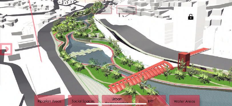
Shawash J., Marji N. | AGATHÓN | n. 08 | 2020 | pp. 220-229

                                                          cation consists of 3 main sections: an intro-           The survey further inquired about the impor-
                                                          ductory Audio-Visual Book (Figg. 5, 6), the AR       tance of the seven project objectives as de-
                                                          Scenarios 3D Model (Figg. 7-9), and the AR           tailed above and the objective scoring the high-
                                                          User Feedback Survey. The Introductory Au-           est mode was ‘offering green open space and
                                                          dio-Visual Book section introduces the user to       water features to the city’, with ‘flooding mitiga-
                                                          the project’s context, its history, current prob-    tion’ and improving quality of life’ almost equal
                                                          lems, and possible solution scenarios. The AR        and not far behind. The objective that garnered
                                                          Scenarios 3D Model utilizes the AR Foundation        the lowest interest was ‘bringing back the
                                                          Framework’s plane detection functionality to         memory of the Seil’. These observations were
                                                          create a marker-less AR experience. Once the         somewhat replicated when respondents were
                                                          user’s phone detects a horizontal surface, the       asked to select one objective of highest priority,
                                                          user can initiate the AR experience and spawn        with ‘offering green space’ scoring highest at
                                                          the virtual 3D Model of the project. The inter-      40%, ‘flooding mitigation’ at 27.5%, and ‘im-
                                                          active 3D Virtual model includes AR buttons          proving quality of life’ at 15%. As for scenario
                                                          that can be triggered through the mobile de-         preference, the majority agreed that the ‘Seil
                                                          vice’s touch screen. The AR scene has two            Amman Park’ was preferable at 75%, while
                                                          main tabs: The 360-degree Views Tab, which           7.5% provided an independent answer sug-
                                                          includes 360-degree rendered images of key           gesting combining both scenarios in a phased
                                                          areas in the model (Figg. 10, 11), and the Infor-    project (Fig. 14). Regarding the biggest per-
                                                          mation Tab which unlocks multiple interactive        ceived obstacle for the implementation of the
                                                          layers that can be activated using Unity’s User      project, the answers were ranked as: 1) ‘low
                                                          Interface (UI) Buttons.                              priority of ecologically oriented urban solutions’
                                                              3D models of the masterplans for scenario        and ‘support of decision-makers’; 2) ‘cost’; 3)
                                                          proposals were optimized and exported from           ‘maintenance and project sustainability’.
                                                          the original CAD software (Autodesk Revit) as           Regarding the application and use of MAR
                                                          low-poly 3D models, then imported into Unity         components, the majority reported no prob-
                                                          to add materials with compressed textures to         lems at 92.5%, with the reported problems
                                                          preserve the performance of the users’ mobile        when present consisting of the functionality of
                                                          devices, and avoid overheating due to the            the tabletop component, device overheating,
                                                          CPU-intensive workload of computation and            installation difficulties and design and layout
                                                          image processing. The last section of the ap-        transferability between different aspect ratios.
                                                          plication serves as a link to an online survey       60% of respondents stated that the application
                                                          form created using Google Forms to collect           was easy to navigate (scoring 4 and 5 on the
                                                          users’ feedback on four main topics: respon-         Likert scale, with 5 being the easiest). The most
                                                          dent characteristics, the development scenar-        enjoyable component of the application was
                                                          ios, the functionality of the application, and the   the 360s views at 60%, while the AR compo-
                                                          overall use of AR technology. The questions in-      nent came second at 50%. Overall, the experi-
                                                          corporated categorical and interval selection,       ence of the application was positive, and 75%
                                                          Likert scale measures, multiple-choice, as well      of respondents reported that it helped to get a
                                                          as open-ended answers.                               better sense of the suggested scenarios. 95%
                                                                                                               of respondents agreed that they would use
                                                          MAR application experiment | The applica-            such an application for public voting for future
                                                          tion was released for both iOS and Android           developments in the city.
                                                          (Fig. 13) platforms via formal application stores
                                                          and announced on social media platforms for          Conclusions | The outputs of this innovative
                                                          a week in September 2020, and further propa-         visualization method showed very positive re-
                                                          gated via word of mouth. The sample was not          action towards the idea of an AR application
                                                          highly randomized as to be able to provide           to showcase potential urban development
Fig. 13 | QR codes for the MAR applications for iOS and   technical support as needed for this pilot ex-       projects and a desire for its implementation as
Android, as well as the survey results form.              periment. A final sample of 40 respondents ful-       a means of public participation and voting. The
Fig. 14 | Charts of survey results showing (top-down)     ly participated in the application. The respons-     use of immersive 3D models simplified com-
age distribution, preference of scenario, and the most    es are available online (Fig. 13). The sample        plex components for non-professionals of dif-
important values to address in the Ras al-Ein area.       consisted of 80% of females and 20% of males.        ferent ages, especially of older age ranges.
                                                          The majority of respondents were in the age          The research revealed a generational gap,
                                                          group 35-44 at 37.5% (Fig. 14). As older groups      whereby the application was deemed relative-
    For developing the Seil of Amman AR Ap-               did not appear responsive during early survey-       ly easy to use for respondents under the age
plication ‘AR Foundation’ was used, which com-            ing, they were purposefully sampled and as-          of 45, while older generations required assis-
bines both ARCore and ARKit, and supports                 sisted in the use of the application due to the      tance and a brief explanation of the project
developing marker-less AR experiences for a               importance of their participation and familiarity    and the AR technology. In terms of use of mo-
wide range of devices. The real-time develop-             with the city. The level of education of respon-     bile devices, a prevalence of iOS users was
ment engine used for developing the Seil of               dents ranged between undergraduate at 45%            observed, it was also noted that iOS devices
Amman MAR Application was Unity 3D as it                  and graduate at 52.5%; while occupation con-         have a faster frame rate when running the AR
offers the possibility of cross-platform develop-         sisted of a majority relating to the fields of ar-    scenes leading to a smoother experience, yet
ment (Android, iOS, Linux, Windows, etc.), us-            chitecture and urban design at 55.3%, but also       are more sensitive to light and plane detection
es an object-oriented scripting language (C#),            including a diverse sample of disciplines of elec-   leading to more difficulty in model spawning.
and offers great flexibility in customization of          tronic engineering, medicine, ecology, chem-             Most respondents selected the more sus-
user-interfaces as well as a rich library of free         istry and history as well as retirees. The used      tainable scenario of Seil Park and showed a
assets, materials, and textures.                          mobile devices ranged between 79% for iOS            positive perspective towards exploring future
                                                          devices with the oldest model at iPhone 7, and       development projects in the city in a similar
Application functionalities and offered AR                21% for Android devices with the oldest model        manner. The reason behind this selection re-
experience | The Seil of Amman MAR Appli-                 at Samsung Galaxy S8+.                               flected the dire need for green space in the city

228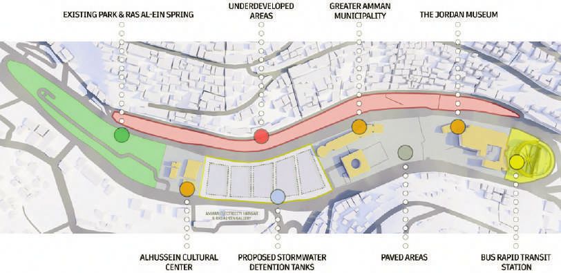
Shawash J., Marji N. | AGATHÓN | n. 08 | 2020 | pp. 220-229

as well as flood mitigation. Older generation re-                  Having explored the potentials of MAR ap-                  of Amman to increase awareness and charge
spondents persisted on choosing the more re-                  plications and the primary reaction of the re-                 the political will. Primary feedback regarding
alistic scenario due to concerns about cost                   spondents in this pilot study, the research opens              the functionality of the application also allows
and suggested a phasing approach for project                  further avenues of exploration. It will be fol-                for the development of a more immersive and
implementation. The qualitative feedback of the               lowed by a more detailed study of the techni-                  accessible tool. The success of this visioning
survey showed that respondents desired to                     cal aspects of the proposals, deeper discus-                   pilot project might lead the way for a potential
see a change in the city after realizing that                 sions with the Municipality and relevant stake-                greener and more inclusive realities for the city
such solutions are possible.                                  holders, and more engagement with the citizens                 of Amman.

References                                                    Butler, D., Arthur, S., Trowsdale, S., Barraud, S., Se-        www.jordantimes.com/news/local/flooding-results-road-
                                                              madeni-Davies, A., Bertrand-Krajewski, J.-L., Mikkel-          closures-complaints-and-rescues-thursday [Accessed 4
   Ababsa, M. (2014), “The Protection of Groundwater          sen, P. S., Rivard, G., Uhl, M., Dagenais, D. and Viklan-      November 2020].
Reserves”, in Ababsa, M. (ed.), Atlas of Jordan – Histo-      der, M. (2015), “SUDS, LID, BMPs, WSUD and More –                 Thompson, E. M. (2015), Envisioning Futures – Visu-
ry, Territories and Society, Presses de l’Ifpo, Beyrouth,     The Evolution and Application of Terminology Sur-              alising Newcastle City Futures 2065. [Online] Available
pp. 431-432. [Online] Available at: books.openedition.org/    rounding Urban Drainage”, in Urban Water Journal,              at: assets.publishing.service.gov.uk/government/uploads
ifpo/5061 [Accessed 3rd August 2020].                         vol. 12, issue 7, pp. 525-542. [Online] Available at:          /system/uploads/attachment_data/file/544833/envision-
   Abu-Dayyeh, N. I. (2004), “Persisting Vision – Plans       doi.org/10.1080/1573062X.2014.916314 [Accessed 6               ing-futures-newcastle.pdf [Accessed 2nd August 2020].
for a Modern Arab Capital, Amman, 1955-2002”, in              August 2020].                                                     UN – General Assembly (2015), Transforming our
Planning Perspectives, vol. 19, issue 1, pp. 79-110. [On-        Gharaibeh, A., Al.Zu’bi, E. M. and Abuhassan, L. B.         world – The 2030 Agenda for Sustainable Development,
line] Available at: doi.org/10.1080/0266543042000177          (2019), “Amman (City of Waters) – Policy, Land Use,            document A/RES/70/1. [Online] Available at: www.un.org/
922 [Accessed 5 August 2020].                                 and Character Changes”, in Land, vol. 8, issue 12, arti-       ga/search/view_doc.asp?symbol=A/RES/70/1&Lang=E
   Alves, A., Vojinovic, Z., Kapelan, Z., Sanchez, A. and     cle 195, pp. 1-25. [Online] Available at: doi.org/10.3390/     [Accessed 14 September 2020].
Gersonius, B. (2020), “Exploring Trade-Offs among the         land8120195 [Accessed 4 November 2020].
Multiple Benefits of Green-Blue-Grey Infrastructure for          Guo, J. C. Y. (2017), Urban Flood Mitigation and
Urban Flood Mitigation”, in Science of The Total Envi-        Stormwater Management, CRC Press.
ronment, vol. 703, article 134980, pp. 1-14. [Online]            Jarrah, A. (2005), Assessing Runoff Potential for Wa-
Available at: doi.org/10.1016/j.scitotenv.2019.134980         ter Harvesting Generation in Jordan, University of
[Accessed 18 August 2020].                                    Manchester.
   American Colony, Photo Department, Photographer               Khirfan, L., Mohtat, N., Pecka, M., Andrew, C. and
(1932), Air route to Baghdad via Amman and the desert.        Maa, L. (2020), “Dataset for assessing the scope and na-
Amman. Distant view. Approaching town from the west           ture of global stream daylighting practices”, in Data in
above Amman valley, Amman, Jordan. [Online] Avail-            Brief, vol. 33, article 106366, pp. 1-22. [Online] Avail-
able at: www.loc.gov/item/2019706712/ [Accessed 7 Au-         able at: doi.org/10.1016/j.dib.2020.106366 [Accessed 3rd
gust 2020].                                                   August 2020].
   Benedict, M. A. and McMahon, E. T. (2006), Green              Munif, A. al-R. (1996), Story of a City – A Childhood
Infrastructure – Linking Landscapes and Communities,          in Amman, Quartet Books Limited.
Island Press, Washington.                                        Novotny, V., Ahern, J. and Brown, P. (2010), Water
   Billinghurst, M., Clark, A. and Lee, G. (2015), “A         Centric Sustainable Communities – Planning, Retrofitting,
Survey of Augmented Reality”, in Foundations and              and Building the Next Urban Environment, John Wiley
Trends in Human-Computer Interaction, vol. 8, issue 2-        & Sons.
3, pp. 73-272, Now Publishers, USA. [Online] Available           Portman, M. E., Natapov, A. and Fisher-Gewirtzman,
at: www.nowpublishers.com/article/Details/HCI-049 [Ac-        D. (2015), “To Go Where No Man Has Gone before –
cessed 9 August 2020].                                        Virtual Reality in Architecture, Landscape Architecture
   Boulos, M. N. K., Lu, Z., Guerrero, P., Jennett, C. and    and Environmental Planning”, in Computers, Environ-
Steed, A. (2017), “From urban planning and emergency          ment and Urban Systems, vol. 54, pp. 376-384. [Online]
training to Pokémon Go – Applications of virtual reality      Available at: doi.org/10.1016/j.compenvurbsys.2015.05.
GIS (VRGIS) and augmented reality GIS (ARGIS) in              001 [Accessed 11 August 2020].
personal, public and environmental health”, in Interna-          Reaver, K. (2019), “Tre casi studio sulla conservazio-
tional Journal of Health Geographics, vol. 16, article 7,     ne virtuale – Applicare la realtà virtuale al Patrimonio
pp. 1-11. [Online] Available at: doi.org/10.1186/s12942-      Culturale | Three Case Studies in Virtual Preservation –
017-0081-0 [Accessed 7 August 2020].                          Applying Virtual Reality to Cultural Heritage”, in Agathón
   Bower, M., Howe, C., McCredie, N., Robinson, A.            | International Journal of Architecture, Art and Design,
and Grover, D. (2014), “Augmented Reality in educa-           vol. 6, pp. 210-217. [Online] Available at doi.org/10.192
tion – Cases, places and potentials”, in Educational Me-      29/2464-9309/6202019 [Accessed 8 August 2020].
dia International, vol. 51, issue 1, pp. 1-15. [Online]          Redondo Domínguez, E., Fonseca Escudero, D., Sán-
Available at: doi.org/10.1080/09523987.2014.889400            chez Riera, A. and Navarro Delgado, I. (2017), “Educat-
[Accessed 9 August 2020].                                     ing Urban Designers using Augmented Reality and Mo-
   Columbia GSAPP (2017), Water Urbanism – Amman              bile Learning Technologies | Formación de Urbanistas
– Global Cities & Climate Change Studio – Spring              usando Realidad Aumentada y Tecnologías de Apren-
2017. [Online] Available at: www.arch.columbia.edu/           dizaje Móvil”, in RIED | Revista Iberoamericana de Ed-
books/reader/194-water-urbanism-amman#reader-an-              ucación a Distancia, vol. 20, n. 2, pp. 141-165. [Online]
chor-0 [Accessed 6 August 2020].                              Available at: doi.org/10.5944/ried.20.2.17675 [Accessed
   Daher, R. F. (2013), “Prelude – Understanding Cul-         2nd August 2020].
tural Change and Urban Transformations – Qualifying              Szpilko, D. (2020), “Foresight as a Tool for the Plan-
Amman – The City of Many Hats”, in Ababsa, M. and             ning and Implementation of Visions for Smart City De-
Daher, R. (eds), Cities, Urban Practices and Nation Build-    velopment”, in Energies, vol. 13, n. 7, article 1782, pp.
ing in Jordan | Villes, pratiques urbaines et construction    1-24. [Online] Available at: doi.org/10.3390/en130717
nationale en Jordanie, Presses de l’Ifpo, Beyrouth, pp. 65-   82 [Accessed 9 August 2020].
89. [Online] Available at: books.openedition.org/ifpo/           The Jordan Times (2019), “Flooding results in road
1725 [Accessed 4 November 2020].                              closures, complaints and rescues on Thursday”, in The
   Fletcher, T. D., Shuster, W., Hunt, W. F., Ashley, R.,     Jordan Times, 28/02/2018. [Online] Available at:

                                                                                                                                                                               229
Puoi anche leggere