REPRESENTATION CHALLENGES - Augmented Reality and Artificial Intelligence in Cultural Heritage and Innovative Design Domain - IRIS Politecnico di ...
←
→
Trascrizione del contenuto della pagina
Se il tuo browser non visualizza correttamente la pagina, ti preghiamo di leggere il contenuto della pagina quaggiù
REPRESENTATION CHALLENGES
Augmented Reality and Artificial Intelligence in
Cultural Heritage and Innovative Design Domain

edited by
Andrea Giordano
Michele Russo
Roberta Spallone

                                        diségno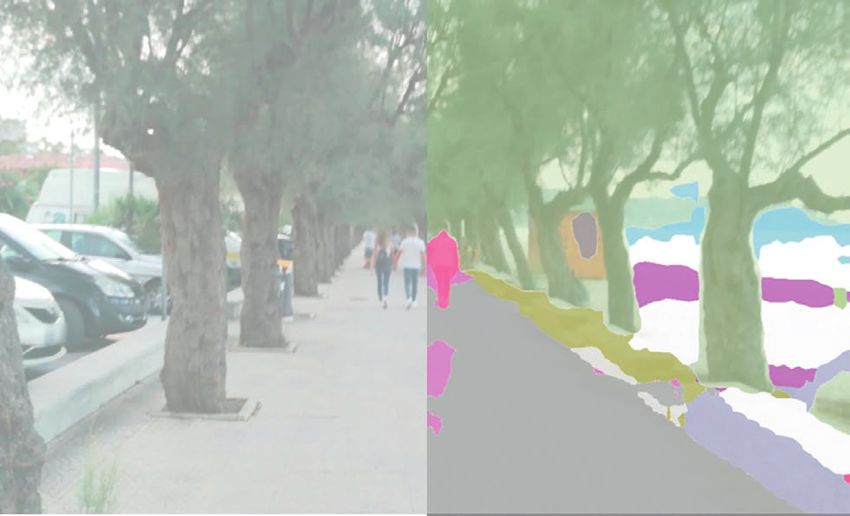
diségno
                                                                the Series of the UID – Unione Italiana per il Disegno

                                                                                                   director Francesca Fatta

The Series contains volumes of the proceedings of the annual conferences of the Scientific Society UID – Unione Italiana per
il Disegno and the results of international meetings, research and symposia organised as part of the activities promoted or
patronised by UID. The topics concern the Scientific Disciplinary Sector ICAR/17 Drawing with interdisciplinary research areas.
The texts are in Italian or in the author’s mother tongue (French, English, Portuguese, Spanish, German) and/or in English.The
international Scientific Committee includes members of the UID Scientific Technical Committee and numerous other foreign
scholars who are experts in the field of Representation.
The volumes of the series can be published either in print or in open access and all the authors’ contributions are subject to
double blind peer review according to the currently standard scientific evaluation criteria.

Scientific Committee
Giuseppe Amoruso Politecnico di Milano
Paolo Belardi Università degli Studi di Perugia
Stefano Bertocci Università degli Studi di Firenze
Mario Centofanti Università degli Studi dell’Aquila
Enrico Cicalò Università degli Studi di Sassari
Antonio Conte Università degli Studi della Basilicata
Mario Docci Sapienza Università di Roma
Edoardo Dotto Università degli Studi di Catania
Maria Linda Falcidieno Università degli Studi di Genova
Francesca Fatta Università degli Studi Mediterranea di Reggio Calabria
Fabrizio Gay Università IUAV di Venezia
Andrea Giordano Università degli Studi di Padova
Elena Ippoliti Sapienza Università di Roma
Francesco Maggio Università degli Studi di Palermo
Anna Osello Politecnico di Torino
Caterina Palestini Università degli Studi “G. d’Annunzio” di Chieti-Pescara
Lia Maria Papa Università degli Studi di Napoli “Federico II”
Rossella Salerno Politecnico di Milano
Alberto Sdegno Università degli Studi di Udine
Chiara Vernizzi Università degli Studi di Parma
Ornella Zerlenga Università degli Studi della Campania “Luigi Vanvitelli”
Members of foreign structures
Caroline Astrid Bruzelius Duke University - USA
Pilar Chías Universidad de Alcalá - Spagna
Frank Ching University of Washington - USA
Livio De Luca UMR CNRS/MCC MAP Marseille - Francia
Roberto Ferraris Universidad Nacional de Córdoba - Argentina
Glaucia Augusto Fonseca Universidade Federal do Rio de Janeiro - Brasile
Pedro Antonio Janeiro Universidade de Lisboa - Portogallo
Jacques Laubscher Tshwane University of Technology - Sudafrica
Cornelie Leopold Technische Universität Kaiserslautern - Germania
Juan José Fernández Martín Universidad de Valladolid - Spagna
Carlos Montes Serrano Universidad de Valladolid - Spagna
César Otero Universidad de Cantabria - Spagna
Guillermo Peris Fajarnes Universitat Politècnica de València - Spagna
José Antonio Franco Taboada Universidade da Coruña - Spagna
Michael John Kirk Walsh Nanyang Technological University - Singapore

Graphic design and cover by Enrico Cicalò and Paola Raffa
This volume is published in open access format, i.e. the file of the entire work can be freely
     downloaded from the FrancoAngeli Open Access platform (http://bit.ly/francoangeli-oa).
  On the FrancoAngeli Open Access platform, it is possible to publish articles and monographs,
   according to ethical and quality standards while ensuring open access to the content itself. It
  guarantees the preservation in the major international OA archives and repositories. Through
the integration with its entire catalog of publications and series, FrancoAngeli also maximizes visi-
                          bility, user accessibility and impact for the author.

                                            Read more:
                  http://www.francoangeli.it/come_pubblicare/pubblicare_19.asp

           Readers who wish to find out about the books and periodicals published
       by us can visit our website www.francoangeli.it and subscribe to our “Informatemi”
                         (notify me) service to receive e-mail notifications.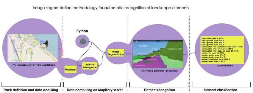
REPRESENTATION CHALLENGES
Augmented Reality and Artificial Intelligence in
Cultural Heritage and Innovative Design Domain

edited by
Andrea Giordano
Michele Russo
Roberta Spallone
REPRESENTATION CHALLENGES
                                                                                                                                Augmented Reality and Artificial Intelligence in
                                                                                                                                Cultural Heritage and Innovative Design Domain

Scientific Committee                                                                             Peer Reviewers

Salvatore Barba                                                                                  Marinella Arena
Università di Salerno                                                                            Università Mediterranea di Reggio Calabria
Marco Giorgio Bevilacqua                                                                         Salvatore Barba
Università di Pisa                                                                               Università di Salerno
Stefano Brusaporci                                                                               Marco Giorgio Bevilacqua
Università dell’Aquila                                                                           Università di Pisa
Francesca Fatta                                                                                  Cecilia Bolognesi
Università Mediterranea di Reggio Calabria                                                       Politecnico di Milano
Andrea Giordano                                                                                  Stefano Brusaporci
Università di Padova                                                                             Università dell’Aquila
Alessandro Luigini                                                                               Francesca Fatta
Libera Università di Bolzano                                                                     Università Mediterranea di Reggio Calabria
Michele Russo                                                                                    Andrea Giordano
Sapienza Università di Roma                                                                      Università di Padova
Cettina Santagati                                                                                Massimo Leserri
Università di Catania                                                                            Università di Napoli “Federico II”
Alberto Sdegno                                                                                   Stefania Landi
Università di Udine                                                                              Università di Pisa
Roberta Spallone                                                                                 Massimiliano Lo Turco
Politecnico di Torino                                                                            Politecnico di Torino
                                                                                                 Alessandro Luigini
                                                                                                 Libera Università di Bolzano
Scientific Coordination                                                                          Pamela Maiezza
                                                                                                 Università dell’Aquila
Andrea Giordano
Università di Padova                                                                             Domenico Mediati
                                                                                                 Università Mediterranea di Reggio Calabria
Michele Russo
Sapienza Università di Roma                                                                      Cosimo Monteleone
                                                                                                 Università di Padova
Roberta Spallone
Politecnico di Torino                                                                            Michele Russo
                                                                                                 Sapienza Università di Roma
                                                                                                 Cettina Santagati
Editorial Committee                                                                              Università di Catania
Isabella Friso                                                                                   Alberto Sdegno
Università IUAV di Venezia                                                                       Università di Udine
Fabrizio Natta                                                                                   Roberta Spallone
Politecnico di Torino                                                                            Politecnico di Torino
Michele Russo                                                                                    Marco Vitali
Sapienza Università di Roma                                                                      Politecnico di Torino

The texts as well as all published images have been provided                                     Patronage
by the authors for publication with copyright and scientific re-
sponsibility towards third parties. The revision and editing is by
the editors of the book.

ISBN printed edition: 9788835116875
ISBN digital edition: 9788835125280

                                                                                  Cover image: Michele Russo

                                                                     Copyright © 2021 by FrancoAngeli s.r.l., Milano, Italy.

                                      This work, and each part thereof, is protected by copyright law and is published in this digital version
                                          under the license Creative Commons Attribution-NonCommercial-NoDerivatives 4.0 International
                                                                              (CC BY-NC-ND 4.0)

                                        By downloading this work, the User accepts all the conditions of the license agreement for the work as
                                                                         stated and set out on the website
                                                               https://creativecommons.org/licenses/by-nc-nd/4.0
Index
7
Francesca Fatta
Preface
9
Andrea Giordano, Michele Russo, Roberta Spallone
Representation Challenges: The Reasons of the Research
AR&AI theoretical concepts AR&AI heritage routes
23 111
Francesco Bergamo Marinella Arena, Gianluca Lax
The Role of Drawing in Data Analysis and Data Representation Saint Nicholas of Myra. Cataloguing, Identification, and Recognition Through AI
29 117
Giorgio Buratti, Sara Conte, Michela Rossi Stefano Brusaporci, Pamela Maiezza, Alessandra Tata, Fabio Graziosi, Fabio Franchi
Artificial Intelligency, Big Data and Cultural Heritage Prosthetic Visualizations for a Smart Heritage
35 123
Marco Ferrari, Lodovica Valetti Gerardo Maria Cennamo
Virtual Tours and Representations of Cultural Heritage: Ethical Issues Advanced Practices of Augmented Reality: the Open Air Museum Systems for
the Valorisation and Dissemination of Cultural Heritage
41
Claudio Marchese, Antonino Nastasi 129
The Magnificent AI & AR Combinations: Limits? Gorgeous Imperfections! Serena Fumero, Benedetta Frezzotti
The Use of AR Illustration in the Promotion of Heritage Sites
47
Valerio Palma 135
Data, Models and Computer Vision: Three Hands–on Projects Alessandro Luigini, Stefano Brusaporci, Alessandro Basso, Pamela Maiezza
The Sanctuary BVMA in Pescara: AR Fruition of the Pre–Conciliar Layout
53
Alberto Sdegno 141
Drawing Automata Alessandra Pagliano, Greta Attademo, Anna Lisa Pecora
Phygitalarcheology for the Phlegraean Fields
59
Marco Vitali, Giulia Bertola, Fabrizio Natta, Francesca Ronco 147
AI+AR: Cultural Heritage, Museum Institutions, Plastic Models and Prototyping. Andrea Rolando, Domenico D’Uva, Alessandro Scandiffio
A State of Art A Technique to Measure the Spatial Quality of Slow Routes in Fragile
Territories Using Image Segmentation
153
Giorgio Verdiani, Ylenia Ricci, Andrea Pasquali, Stéphane Giraudeau
When the Real Really Means: VR and AR Experiences in Real Environments
AR&AI virtual reconstruction 159
Ornella Zerlenga, Vincenzo Cirillo, Massimiliano Masullo, Aniello Pascale, Luigi Maffei
67 Drawing, Visualization and Augmented Reality of the 1791 Celebration in Naples
Alessio Bortot
Physical and Digital Pop–Ups. An AR Application in the Treatises on
Stereotomy
73
Maurizio Marco Bocconcino, Mariapaola Vozzola
AR&AI classification and 3D analysis
The Value of a Dynamic Memory: from Heritage Conservation in Turin
167
79 Marco Giorgio Bevilacqua, Anthony Fedeli, Federico Capriuoli, Antonella Gioli, Cosimo
Antonio Calandriello Monteleone, Andrea Piemonte
Augmented Reality and the Enhancement of Cultural Heritage: the Case of Immersive Technologies for the Museum of the Charterhouse of Calci
Palazzo Mocenigo in Padua
173
85 Massimiliano Campi, Valeria Cera, Francesco Cutugno, Antonella di Luggo, Domenico
Cristina Càndito, Andrea Quartara, Alessandro Meloni Iovane, Antonio Origlia
The Appearance of Keplerian Polyhedra in an Illusory Architecture CHROME Project: Representation and Survey for AI Development
91 179
Maria Grazia Cianci, Daniele Calisi, Sara Colaceci, Francesca Paola Mondelli Paolo Clini, Roberto Pierdicca, Ramona Quattrini, Emanuele Frontoni, Romina Nespeca
Digital Tools at the Service of Public Administrations Deep Learning for Point Clouds Classification in the Ducal Palace at Urbino
97 185
Riccardo Florio, Raffaele Catuogno, Teresa Della Corte, Veronica Marino Pierpaolo D’Agostino, Federico Minelli
Studies for the Virtual Reconstruction of the Terme del Foro of Cumae Automated Modelling of Masonry Walls: a ML and AR Approach
103 191
Maurizio Perticarini, Chiara Callegaro Elisabetta Caterina Giovannini
Making the Invisible Visible: Virtual/Interactive Itineraries in Roman Padua Data Modelling in Architecture: Digital Architectural Representations197 315
Marco Limongiello, Lucas Matias Gujski Paola Puma, Giuseppe Nicastro
Image–Based Modelling Restitution: Pipeline for Accuracy Optimisation The Emotion Detection Tools in the Museum Education EmoDeM Project
203 321
Federica Maietti, Marco Medici, Ernesto Iadanza Leopoldo Repola, Nicola Scotto di Carlo, Andrea Maioli, Matteo Martignoni
From AI to H–BIM: New Interpretative Scenarios in Data Processing MareXperience. AI/AR for the Recognition and Enhancement of Reality
209
Michele Russo, Eleonora Grilli, Fabio Remondino, Simone Teruggi, Francesco Fassi
Machine Learning for Cultural Heritage Classification
215 AR&AI building information modeling and monitoring
Andrea Tomalini, Edoardo Pristeri, Letizia Bergamasco
Photogrammetric Survey for a Fast Construction of Synthetic Dataset 329
Vincenzo Bagnolo, Raffaele Argiolas, Nicola Paba
Communicating Architecture. An AR Application in Scan–to–BIM Processes
335
Marcello Balzani, Fabiana Raco, Manlio Montuori
AR&AI urban enhancement Integrated Technologies for Smart Buildings and PREdictive Maintenance
341
223 Fabrizio Banfi
Giuseppe Amoruso, Polina Mironenko, Valentina Demarchi Extended Reality (XR) and Cloud–Based BIM Platform Development
Rebuilding Amatrice. Representation, Experience and Digital Artifice
347
229 Carlo Biagini, Ylenia Ricci, Irene Villoresi
Paolo Belardi, Valeria Menchetelli, Giovanna Ramaccini, Margherita Maria Ristori, H–Bim to Virtual Reality: a New Tool for Historical Heritage
Camilla Sorignani
AR+AI = Augmented (Retail + Identity) for Historical Retail Heritage 353
Fabio Bianconi, Marco Filippucci, Giulia Pelliccia
235 Experimental Value of Representative Models in Wooden Constructions
Fabio Bianconi, Marco Filippucci, Marco Seccaroni
New Interpretative Models for the Study of Urban Space 359
Devid Campagnolo, Paolo Borin
241 Automatic Recognition Through Deep Learning of Standard Forms in Executive
Marco Canciani, Giovanna Spadafora, Mauro Saccone, Antonio Camassa Projects
Augmented Reality as a Research Tool, for the Knowledge and Enhancement of
Cultural Heritage 365
Matteo Del Giudice, Daniela De Luca, Anna Osello
247 Interactive Information Models and Augmented Reality in the Digital Age
Alessandra Pagliano
Augmenting Angri: Murals in AR for Urban Regeneration and Historical Memory 371
Marco Filippucci, Fabio Bianconi, Michela Meschini
253 Survey and BIM for Energy Upgrading. Two Case Study
Caterina Palestini, Alessandro Basso
Evolutionary Time Lines, Hypothesis of an AI+AR–Based Virtual Museum 377
Raissa Garozzo
259 A Proposal for Masonry Bridge Health Assessment Using AI and Semantics
Daniele Rossi, Federico O. Oppedisano
Marche in Tavola. Augmented Board Game for Enogastronomic Promotion 383
Federico Mario La Russa
AI for AEC: Open Data and VPL Approach for Urban Seismic Vulnerability
AR&AI museum heritage 389
Assunta Pelliccio, Marco Saccucci
V.A.I. Reality. A Holistic Approach for Industrial Heritage Enhancement
267
Massimo Barilla, Daniele Colistra
An Immersive Room Between Scylla and Charybdis
273
Francesco Borella, Isabella Friso, Ludovica Galeazzo, Cosimo Monteleone, Elena Svalduz
AR&AI education and shape representation
New Cultural Interfaces on the Gallerie dell’Accademia in Venice
397
279 Maria Linda Falcidieno, Maria Elisabetta Ruggiero, Ruggero Torti
Laura Carlevaris, Marco Fasolo, Flavia Camagni Visual Languages: On–Board Communication as a Perception of Customercaring
Wood Inlays and AR: Considerations Regarding Perspective
403
285 Emanuela Lanzara, Mara Capone
Giuseppe D’Acunto Genetic Algorithms for Polycentric Curves Interpretation
Augmented Reality and Museum Exhibition. The Case of the Tribuna of Palazzo
Grimani in Venice 409
Anna Lisa Pecora
291 The Drawn Space for Inclusion and Communicating Space
Giuseppe Di Gregorio
The Rock Church of San Micidiario of the Pantalica Site and 3DLAB VR/AR–Project 415
Marta Salvatore, Leonardo Baglioni, Graziano Mario Valenti, Alessandro Martinelli
297 Forms in Space. AR Experiences for Geometries of Architectural Form
Elena Ippoliti
Understanding to Enhance, Between the Technical and Humanist Approaches 421
Roberta Spallone, Valerio Palma
303 AR&AI in the Didactics of the Representation Disciplines
Gabriella Liva, Massimiliano Ciammaichella
Illusory Scene and Immersive Space in Tintoretto’s Theatre 427
Alberto Tono, Meher Shashwat Nigam, Stasya Fedorova, Amirhossein Ahmadnia,
309 Cecilia Bolognesi
Franco Prampolini, Dina Porpiglia, Antonio Gambino Limitations and Review of Geometric Deep Learning Algorithms for Monocular
Medma Touch, Feel, Think: Survey, Catalog and Sensory Limitations 3D Reconstruction in ArchitectureREPRESENTATION CHALLENGES
Augmented Reality and Artificial Intelligence in
Cultural Heritage and Innovative Design Domain
A Technique to Measure the Spatial
Quality of Slow Routes in Fragile
Territories Using Image Segmentation
Andrea Rolando
Domenico D’Uva
Alessandro Scandiffio
Abstract
The current research aims at investigating the potential of image segmentation (IS) technology, based
on web application, for measuring the spatial quality of slow routes. The big amount of street–level
images, publicly available through several applications such as Mapillary, Google Street View, are rele-
vant sources of information, that allow virtual explorations of many places around the world. The (IS)
technology allows partitioning of a single digital image into sets of pixels in order to read and recognize
the visual content within the frame of the image. By applying IS technology to the images taken along
a defined route, it has established a method for grouping images in relation to their spatial features.
The method has been applied to some stretches of slow–mobility routes, that are localized along the
fragile coastal landscape of Trabucchi, south of Italy. A selection of images along the route, both in the
outdoor and urban space, has been analyzed, with the aim to test the effectiveness of the method, able
to produce useful information to define a Spatial Quality Index.
Keywords
slow routes, mapping, spatial quality, image segmentation, fragile territories.
doi.org/10.3280/oa-686.23
147Introduction
The methodology presented in this paper results from a search for a solution to the
problem of assessing the spatial quality of slow mobility routes [Scandiffio 2019; Bianchi
et al. 2020], that are located off the beaten tracks, crossing territories that are marginal
and distant from densely populated areas. The majority of studies on the subject refer to
major urban centers, neglecting fragile areas of the territory. These areas are often char-
acterized by a structural lack of data, which makes in–depth analysis difficult. However, it
is possible to perform advanced research methods in the field of spatial analysis, by ex-
ploiting the potential of street–level imagery, users’ generated contents that are available
on the web portals. These methods belong to the Artificial Intelligence (AI) family. It is
beyond the scope of this work to make a detailed analysis because, within this particular
type of software, there are many subsets, each of which has a specific function [Zhang et
al. 2018; Zhang et al. 2019; Cao et al. 2018]. The current research refers to a particular
system of Machine Learning, named Deep Learning, that is based on Neural Networks
[Buratti et al. 2020]. This particular subsystem allows analysing imagery and recognizing
elements already present in an internal database of the machine. The use of an AI system
is necessary because the database does not contain precisely the identified element, but
only a series of similar elements that are analyzed and compared until an ideal candidate
for the final recognition is found. The system, therefore, learns from the elements supplied
to it and increases its knowledge step by step. Once the element has been recognized in
the image, an even more specific procedure is used, called Image Segmentation (IS), which
perimeters the object providing its position and area. Thus, this digital ecosystem returns
the position and quantification of an element within a single image, which corresponds
to a geo–referenced coordinate of the landscape. By performing the IS method to a se-
quence of geo–referenced imagery, it is possible to capture the landscape features along
the route , which can be used for measuring its spatial quality. It is important to underline
that the interpretation and assessment of the quality cannot be fully automated in the first
instance: correct reading and interpretation of images must be prepared, defined and pro-
gressively tuned through an iterative process of machine training, possibly implemented
and improved by massive users contributions. The process is in fact based on comparative
assessments and still requires, in any case, a direct experience of places.
Case Study
The case study to which the methodology was applied is the Costa dei Trabucchi greenway
in Abruzzo Region; a greenway converted into a tourist cycle route since 2017 [Marcarini,
Rovelli 2018]. This route will stretch, upon completion, for 40 kilometers between Orto-
na and San Salvo. At the time of writing this work, it is almost wholly completed in two
sections; the first to the north between Ortona and Fossacesia and the second to the
south between Casalbordino and San Salvo. The northern section of this route was pri-
marily constructed by the Adriatic railway line’s retreat, leaving a void along the coast. It is
currently almost completed and is accessible except for the tunnels, which are still under
renovation. The southernmost section is a route that stitches together different territorial
environments, the coastal towns of Casalbordino, Vasto, San Salvo, and the Regional Nature
Reserve of Punta Aderci.This section has been entirely completed, except for the complete-
ly inaccessible tunnels. The coastline landscape along the route is very scenic, with wide and
sandy beaches that alternate to natural cliffs that are interrupted by small urban settlements.
Both sections are located protected natural areas of great value such as the Reserve of the
Butterfly Cave and the Lecceta di Torino di Sangro and Trabucchi in San Vito, Fossacesia,
and Vasto. For the purposes of the study, shots were selected in 6 sections belonging to
the two sections. Often, the elements, that are in–between the cycle path and the sea, such
as vegetation and houses, impede the landscape’s unobstructed view, sometimes trapping
the route in canyons in which the perception of the valuable elements of the landscape is
seriously compromised.
148Methodology
The current methodology starts from the imagery surveying of the route, which has
allowed to record the GPS track and to take photographs, orthogonal to the route
direction, every 10 meters, by using the web application Mapillary [Porziy et al. 2020]. It is
a web platform that automates mapping tools, by collecting street–level imagery taken by
users with a standard smartphone. Mapillary exploits computer vision tools [Warburgy
et al. 2020] and it allows the recognition system’s application. The methodology is based
on the object detection in images, based on IS technology. This technology is part of
the digital ecosystem of Machine Learning that allows the recognition of the perimeter
of objects and their measurements within the whole image. The objects are assimilated
to the elements included in a training model already existing in the Machine Learning
engine, and a percentage of occupation of the framed field of view is provided. An ad hoc
algorithm has been written in Python language with the aim of extracting quantitative data
related to each image. This algorithm makes it possible to shift the IS’ heavy computational
burden from local machines to remote cloud systems that operate the recognition in a
much more efficient way.The image elements are extracted in the form of very rich JSON
archives because they include the type of object, the area occupied in the image by each
object, the recognition reliability percentage, and the coordinates of all the points that
define the perimeter of the object. The algorithm skims all objects that occupy an area of
less than 5% of the entire field of view, returning only the family and sub–family to which
the object belongs, and the area occupied.
Fig. 1. Workflow of the
Image segmentation
methodolgy for automatic
recognition of landscape
elements
The grouping of images has been done by considering three main layouts as reference
for the scenes. The layouts have been drawn, by selecting the horizontal surface of the
path, the vertical obstructions and the openness of the sky. By assuming the horizontal
surface of the path as an invariant component of all images, different thresholds of the area
percentage of each component of the scene have been applied, in order to analyze the
surfaces in the surrounding of the path, which, effectively, affect the landscape perception.
Three different scene–types have been defined for grouping images. The scene–type 1
corresponds to an open environment, with small vertical elements on the sides and on the
background of the image. The scene–type 2 corresponds to an environment where a wider
surface of vertical elements is present only on one side. The scene–type 3 corresponds to
a closer environment, surrounded by vertical elements on both sides. For each scene–type
two different images, belonging to the outdoor and to the urban environment, have been
selected, in order to test the effectiveness of the method. Both images of each scene–type
have been selected in the same range of area percentage values (fig. 3). For each image it
has been extracted the area percentage of each object in the image, through the Python
algorithm. The raw values of area percentage, derived from the IS, have been grouped into
eight main categories (path, sky, vegetation, edgings, water, terrain, buildings, mobile objects),
in order to simplify the categorization and allow an immediate reading. For each category,
it has been computed the area percentage.
149Outcomes
By processing the images with IS, three different thresholds have been identified for assessing the
spatial quality of the landscape crossed by the route.The threshold values of the sky and vertical
elements (vegetation, buildings, edgings) seem to be the most interesting indicators to outline the
features of the scene.
The images in the scene–type 1 have the area percentage of the sky more than 40%, and the
sum of the area percentage of vertical surfaces (edgings, buildings, vegetation and mobile objects:
people and cars) is less than 30%.The images in the scene–type 2, the area percentage of the sky
less than 40%, and the sum of the area percentage of vertical surfaces is among 30% and 40%.
The images in scene–type n. 3 have the area percentage of the sky less than 20%, while the sum
of the area percentage of vertical surfaces is more than 40%. The thresholds values identified in
this research, could be modified and adapted, if they are tested in other environmental contexts.
Fig. 2. Comparative table
of landscape features
along the “via verde della
Costa dei Trabucchi”
greenway.
Conclusion and Future Research Developments
The limits of this methodology are twofold.The first is related to the system’s problems, the second
to the limitations of images data provision. The Mapillary system only allows the recognition of
elements that can be read by referring to a database which is pre–defined by its developers and
not open to changes.Therefore, some elements typical of the area covered by the case study are
not taken into account. For example, the trabucchi, amphibious machines that are the main heritage
– from which the coast itself takes its name – are selected as Void objects, not recognized.These
objects along with other notable features, are not recognized because the Mapillary database only
includes standard features. It would be necessary to customize the database to select only those
objects that are expected to be retrieved according to their relevance for our specific qualitative
analysis. Such an update of the tool could take advantage of the peculiar characteristic of Machine
Learning systems, namely the ability to learn through analysis, and improve its precision and
reliability. However, the problem arises when training this new database, whose operation requires
significant machine time resources and the need to rely on external structures to complete the
process. During the analysis of the case studio, problems were encountered in the recognition
system because only 100 items per image are analyzed at any one time.The main features could
be included in this value, but some attempts at element recognition only found 51% of them.
This limitation can be overcome by directing the system to search for single categories of objects,
instead of the totality, by expanding the number of detectable elements. To overcome this first
type of limitations, the evolution of methodology will consist of updating the Python algorithm of
parameter extraction, e.g., implementing the grouping of the elements recognized in the indicated
categories. This procedure would start from the sum of the elements with equal features to
automatically group and draw a graph of what is currently done manually.
The second type of limitation concerns how photographs are taken. A positive aspect of Mapillary
is the possibility to survey using a standard smartphone.This flexibility implies a significant problem
for recognition: namely the angle between the direction (perpendicular, along the lens axis to the
smartphone sensor) and the horizon. Tilting the field of view downwards increases the amount
of land (increasing the number of elements included and incurring in the problem told above) in
150the frame.Tilting it in the opposite direction increases the percentage of the sky that fills the frame.
The incidence of this factor will be the subject of future research developments. A further
limitation of this type is the standardization of the photos because they are taken with various
instruments with different resolutions and fields of view, with intuitively different results. The
differences induced by these limitations can be overcome by using standardized tools for
capturing photos, implementing a camera whose inclination, position, and shock–absorber can
be controlled within specific well–defined parameters. A completely different approach to this
issue is relying on more reliable photo databases such as Google Street View [Zhanga et al.
2020; Anguelov et al. 2020] but with limited coverage of the slow mobility routes covered in this
work. A better definition of the thresholds for each category can be found, in order to apply
the method to other territorial contexts. Related to this problem is the limited portion of the
space that is framed by the images. In fact, this method only allows to detect the landscape
elements that are framed in the images.The application of other methods that define landscape
components extracting them from GIS database could be integrated in the procedure.The best
foreseen solution could aim to define the most relevant components of a landscape extracting
and defining them both from GIS databases (made of geometric entities derived from visual
knowledge) and from Image Segmentation procedures, that feed a similar database, but using
visual recognition of the same entities. In the end this double checked definition of entities should
assure the correct definition of each item. Further developments could investigate the possibility
to define a set of relevant objects referred to geometric entities (points, lines, surfaces) to be
considered as common database records, so to be recognized and confronted both in the image
segmentation based process and in its complementar GIS based method of analysis.
Acknowledgments
This work has been carried on within the activities of the E–scapes research group (www.e–scapes.polimi.it directed by A.
Rolando) and the Territorial Fragilities Program – MapFrag group (www.eccellenza.dastu.polimi.it) of the Department of
Architecture and Urban Studies.
References
Anguelov Dragomir, Dulong Carole, Filip Daniel, Frueh Christian, Lafon Stéphane, Lyon Richard, Ogale Abhijit S. , Vincent Luc,
Weaver Josh (2010). Google Street View: Capturing the World at Street Level. In Computer, 43(6,) pp. 32-38.
Bianchi Alessandro, D’Uva Domenico, Rolando Andrea, Scandiffio Alessandro (2020). A View from the Track: Measuring Spatial
Quality of Slow Mobility Routes. Possible Integration of GIS and Machine Learning Based Methods. In Connettere Connecting. Un
disegno per annodare e tessere/drawing for weaving relationships. Milano: FrancoAngeli, pp. 2973-2980.
Cao Rui, Zhu Jiasong,Tu Wei, Li Qingquan (2018). Integrating Aerial and Street View Images for Urban Land Use Classification.
In Remote Sensing, 10, pp. 1-23.
Marcarini Albano, Rovelli Roberto (2018). Atlante Italiano delle ferrovie in disuso. Firenze: Istituto Geografico MIlitare.
Porziy Lorenzo , Hofingerz Markus, Ruiz Idoia, Serrat Joan, Rota Bul`oy Samuel, Kontschiedery Peter (2020). Learning Multi–
Object Tracking and Segmentation from Automatic Annotations. In Computer Vision and Pattern Recognition, arXiv.
Scandiffio Alessandro (2019). Mapping spatial quality of slow routes with a GIS–based method. A comparative assessment of
alternative routes. In International Archives Photogrammetry Remote Sensing Spatial Information Science, XLII–2/W15, pp.1071-1076.
Warburgy Frederik, Haubergy Søren, Lopez–Antequeraz Manuel, Gargalloz Pau, Kuangz Yubin, Civerax Javier (2020). Mapillary
Street–Level Sequences: A Dataset for Lifelong Place Recognition. In Conf. on Computer Vision and Pattern Recognition
(CVPR), pp. 1-10.
Zhang Fan, Zhou Bolei, Ratti Carlo (2019). Discovering place–informative scenes and objects using social media photos. In
Royal Society open science, 6 (3).
Zhang Fan, Zhou Bolei, Liu Liu, Liu Yu, Fung Helene H. , Lin Hui, Ratti Carlo (2018). Measuring human perceptions of a large–
scale urban region using machine learning. In Landscape and Urban Planning, 180, pp. 148-160.
Zhang Fan, Zuc Jinyan, Huc Mingyuan, Zhub Di, Kangd,Yuhao, Gaod Song, Zhang Yi, Huang Zhou (2020). 101478 Uncovering inconspicuous
places using social media check–ins and street view images. In Computer, Environment and Urban Systems. Amsterdam: Elsevier.
Authors
Andrea Rolando, Dept.of Architecture and Urban Studies, Politecnico di Milano, andrea.rolando@polimi.it
Domenico D’Uva, Dept. of Architecture and Urban Studies, Politecnico di Milano, domenico.duva@polimi.it
Alessandro Scandiffio, Dept. of Architecture and Urban Studies, Politecnico di Milano, alessandro.scandiffio@polimi.it
Copyright © 2021 by FrancoAngeli s.r.l. Milano, Italy Isbn 9788835125280
151Puoi anche leggere