REMOTE MONITORING OF NATURAL SLOPES: INSIGHTS FROM THE FIRST TERRESTRIAL INSAR CAMPAIGN IN VIETNAM
←
→
Trascrizione del contenuto della pagina
Se il tuo browser non visualizza correttamente la pagina, ti preghiamo di leggere il contenuto della pagina quaggiù
DOI: 10.4408/IJEGE.2020-01.O-05
REMOTE MONITORING OF NATURAL SLOPES: INSIGHTS FROM THE FIRST
TERRESTRIAL INSAR CAMPAIGN IN VIETNAM
SAVERIO ROMEO(*,**), QUOC CUONG TRAN (***), GIANDOMENICO MASTRANTONI(**),
DUC DO MINH (****), DUC DAO MINH (***,*****), HUY THANG NGUYEN(***),
DUC ANH NGUYEN(***) & PAOLO MAZZANTI(*,**)
(*)
NHAZCA S.r.l., spin-off of “Sapienza” University of Rome – Via V. Bachelet, 12 – 00185 Rome, Italy
(**)
Sapienza” University of Rome, Department of Earth Sciences – Piazzale Aldo Moro, 5 – 00185 Rome, Italy
(***)
Institute of Geological Sciences – VAST, 84 Chua Lang Str., Dong Da Dist., Hanoi, Vietnam
(****)
VNU University of Science, 334 Nguyen Trai Str., Thanh Xuan Dist., Hanoi, Vietnam
(*****)
Graduate University of Science and Technology–VAST, 18 Hoang Quoc Viet, Hanoi, Vietnam
Corresponding authors: saverio.romeo@uniroma1.it, tqcuong@igsvn.vast.vn
EXTENDED ABSTRACT
Il presente lavoro, realizzato nell'ambito di un progetto di ricerca finanziato dal Vietnamese Space Science & Technology Program,
mostra i primi risultati di una campagna di monitoraggio da remoto della frana di Nam Dan (Vietnam settentrionale) dove, per la prima
volta nel Paese, è stata utilizzata la tecnica dell'Interferometria SAR Terrestre (TInSAR). Tale tecnica si basa sull’utilizzo di un sensore
radar installato su una piattaforma terrestre che trasmette il segnale nel campo delle microonde (banda Ku) e ne riceve gli echi di ritorno
dai target riflettenti. Il sensore utilizzato è costituito da due antenne (una trasmittente e una ricevente) e si muove seguendo una traiettoria
lineare lungo un binario. Grazie a questa tecnica è possibile effettuare da remoto il monitoraggio delle deformazioni del terreno,
raggiungendo una precisione sub-millimetrica in condizioni ideali (ad es. breve distanza, alta riflettività, etc.).
Le attività di monitoraggio sono state condotte nel villaggio di Nam Dan, dove una frana attiva con diverse evidenze geomorfologiche
quali scarpate, crepe, contropendenze con ristagni d’acqua, abitazioni e beni pubblici gravemente danneggiati, costituisce una seria
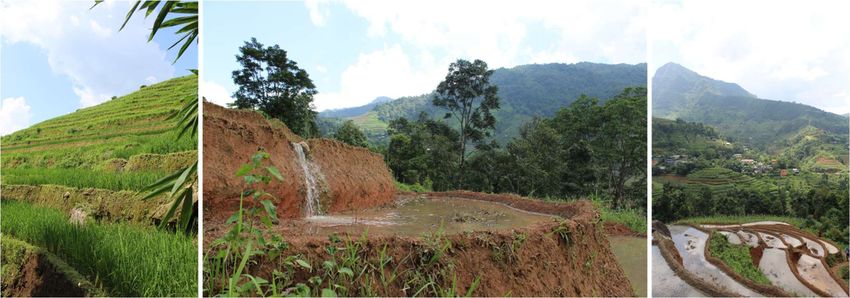
minaccia per la popolazione locale. L’area di Nam Dan (22°36'N; 104°29'E) si trova nella parte meridionale del distretto di Xin Man, in
prossimità del confine tra Vietnam e Cina. Tale distretto, caratterizzato da un clima monsonico umido subtropicale, si estende su un'area
di circa 582 km2ed è caratterizzato da una topografia complessa con catene montuose, pendii terrazzati e valli molto profonde con processi
erosivi avanzati. Gli archivi locali riportano che in tale area, dal 2012 al 2016, si sono verificate 967 frane, principalmente durante l'estate
in corrispondenza delle piogge monsoniche del sud-ovest. Secondo recenti indagini e osservazioni sul campo, la frana oggetto di studio,
verificatasi nel luglio del 2012 in seguito a forti precipitazioni, può classificarsi come uno scivolamento traslativo di detrito e si estende su
un'area di circa 12.000 m2 con una profondità media di circa 22,5 metri. Nell'agosto del 2013 la frana ha causato nuovi gravi danni a 5
abitazioni, al mercato comunale e alla strada provinciale n. 178 e rappresenta tutt’oggi un grave pericolo per la popolazione residente.
Le attività di monitoraggio sono state effettuate tra agosto e dicembre 2019 attraverso un nuovo interferometro radar denominato
Phoenix, che è stato utilizzato in una delle sue prime applicazioni sul campo. Il monitoraggio tramite Interferometria SAR Terrestre ha
avuto l’obiettivo di controllare l’evoluzione del versante instabile ed ha portato alla realizzazione di mappe di spostamento e delle relative
serie temporali, fornendo informazioni dettagliate sulla localizzazione e sui tassi di deformazione dei processi gravitativi di versante
presenti.
Sebbene nel periodo monitorato non siano state registrate deformazioni significative, l'utilizzo di questa tecnica di telerilevamento,
insieme alla strumentazione a contatto precedentemente installata (inclinometri, piezometri, pluviometri) ed alle indagini sul campo, hanno
contribuito a migliorare la conoscenza della frana di Nam Dan e la comprensione del suo cinematismo, con particolare riguardo
all'evoluzione temporale delle deformazioni superficiali, anche tenendo conto delle condizioni meteorologiche locali. I risultati ottenuti
durante la campagna di monitoraggio, in combinazione con i dati precedentemente acquisiti ed elaborati, confermano che il versante oggetto
di studio è caratterizzato da fenomeni di instabilità gravitativa, che possono essere innescati da precipitazioni intense che solitamente
avvengono nell’area durante la stagione estiva.
In considerazione dei contesti ambientali dell'area, quali le severe condizioni climatiche e le aree impervie da percorrere in assenza di
infrastrutture viarie adeguate, è stato posto l'accento sulle attività operative sul campo e sull'individuazione di soluzioni tecnologiche
appropriate, che hanno rappresentato aspetti particolarmente sfidanti per il monitoraggio di fenomeni franosi tramite tecniche di
telerilevamento.
Italian Journal of Engineering Geology and Environment, 1 (2020) © Sapienza Università Editrice www.ijege.uniroma1.it 55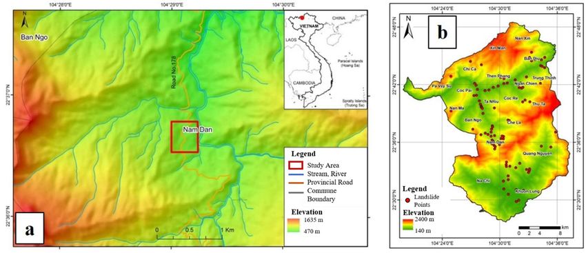
S. ROMEO, Q. C.TRAN, G. MASTRANTONI, D. DO MINH, D. DAO MINH, H. T. NGUYEN, D. A. NGUYEN & P. MAZZANTI

     ABSTRACT                                                                                scale, from short-term to long-term periods, from contact to non-
          The present work, realized in the framework of a research                          contact instrumentations. In this context, remote sensing
     project funded by the Vietnamese Space Science & Technology                             techniques represent one of the main innovations of the latest
     Program, shows the first insights of remote monitoring at the                           years in the field of landslide monitoring and assessment
     Nam Dan landslide (Northern Vietnam). The Terrestrial SAR                               (MAZZANTI et alii, 2015). Terrestrial SAR Interferometry
                                                                                             (TInSAR) is a fully remote monitoring technique allowing to
     Interferometry (TInSAR) technique was used for the first time
                                                                                             identify possible unstable sectors of a slope thanks to a
     in the Country.
                                                                                             widespread view and to cross-validate the displacement time
          The activities were performed in Nam Dan village, where an
                                                                                             series by the huge number of monitoring points (BOZZANO et alii,
     active landslide with several geomorphological evidences as
                                                                                             2010; LUZI, 2010; MAZZANTI et alii, 2015). It is important to
     open cracks and scarps, severely damaged dwellings and public
                                                                                             highlight that the use of Terrestrial SAR technique is able to
     assets, constituting a serious hazard to the local inhabitants. The
                                                                                             measure with high accuracy surface deformations, thus it is
     monitoring activities were carried out between August and
                                                                                             particularly suitable for shallow slope movements (ROMEO et
     December 2019 through a new TInSAR device called Phoenix
                                                                                             alii, 2014). However, a multi-instrumental approach is essential
     which it was used for one of its first on-field applications. The
                                                                                             to investigate both surface and in-depth movements, and the use
     Terrestrial SAR was aimed at creating displacement maps and
                                                                                             of different monitoring techniques allows performing a cross
     related time series, providing detailed information on the
                                                                                             analysis of the data and to minimize errors, to check the data
     location and deformation rate of the processes under
                                                                                             quality and to improve the monitoring system (DI MATTEO et
     investigation. The use of such a remote sensing technique,
                                                                                             alii, 2016). In the present work, the integration of both remote
     coupled with contact instrumentation (inclinometers,
                                                                                             sensing and contact measurements, supported by field
     piezometers, rain gauge) and field surveys have contributed to
                                                                                             observations, have led to the improvement of the landslide
     improving the knowledge about the Nam Dan landslide and the
                                                                                             process understanding and to the quantification of deformations,
     understanding of its behaviour, with particular regard to the time
                                                                                             which affected structures and buildings.
     evolution of deformations.
                                                                                                  This work aims to present recent insight from the remote
     KEYWORDS: landslide, monitoring, Terrestrial SAR Interferometry, Nam
                                                                                             monitoring of a natural slope performed through Terrestrial SAR
     Dan landslide                                                                           Interferometry technique (TInSAR) adding to the literature a
                                                                                             challenging case study in the remote mountainous regions of
     INTRODUCTION                                                                            northern Vietnam. This work demonstrates the versatility of
          Landslides represent a critical problem in many                                    such ground-based monitoring technique, which can be used in
     mountainous regions where slopes are often destabilized by both                         a variety of contexts including the most environmentally
     severe weather conditions and man-made factors. This problem                            demanding.
     is of particular concern in Northern Vietnam, where landslides
     occur in almost all mountainous areas due to the tropical                               STUDY AREA
     rainstorms during the Southwest monsoon season (AHLHEIM et                              General framework
     alii, 2008). In such contexts, as a result of landslide processes,                          The Nam Dan Municipality (22°36’N; 104°29’E) is located
     roads are blocked for several days, agricultural fields are                             in the Southern part of Xin Man district, the western part of Ha
     devastated, buildings and public structure register extensive                           Giang province, in the vicinity of the Vietnam-China border
     damage. In these upland regions, populated by poor rural                                (Fig. 1a). The Xin Man district, that covers an area of about 582
     communities relying on agriculture for their livelihood, often on                       km2, is characterized by a complex topography consisting of
     steep slope, natural hazard-induced disasters exacerbate their                          high mountains, terraced slopes and very deep valleys with
     livelihood vulnerability reducing households’ capacity to face                          advanced erosive processes. The drainage system of the region
     risks (PHAM et alii, 2020). Therefore, studies focused on                               is developed with the Nam Dan River and many its tributaries:
     landslide processes for the definition of effective measures of                         Che La, Nam Tra, Nam Chien streams. Such a district, where the
     landslide risk prevention and management are highly necessary                           elevation ranges from 140 to 2,400 m a.s.l. (average elevation
     for this area.                                                                          over 1,000 m a.s.l.), is a subtropical humid monsoon climate
          Among various methods for the landslide risk prevention,                           zone characterized by heavy rainfalls during the summer season
     monitoring is considered one of the most effective ways and                             (about 1,700 mm/year, QUOC ANH et alii, 2017) make it one of
     plenty of literature is available for successful applications of                        the most landslide-prone areas of the whole Vietnam. Local
     different monitoring systems, from regional to site-specific                            disaster archives report that in such area 967 landslides occurre

56   Italian Journal of Engineering Geology and Environment, 1 (2020)   © Sapienza Università Editrice                                    www.ijege.uniroma1.it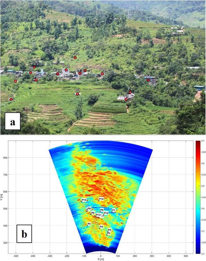
REMOTE MONITORING OF NATURAL SLOPES: INSIGHTS FROM THE FIRST TERRESTRIAL INSAR CAMPAIGN IN VIETNAM

  Fig. 1 - a) Location map of the study area; b) Landslides inventory map in the surrounding areas of Nam Dan village (data from program code SRV-
           10/0026 and project VT-UD.05/18-20)

from 2012 to 2016 (NGOC et alii, 2016), mainly during summer.                           they build terraced fields for rice and crop cultivation. Such
Thanks to a recent field survey (DAO MINH et alii, 2018), more                          farming method requires a large amount of water, which is stored
than 70 landslides have been detected in the surrounding areas                          directly on the terraced fields. affecting the slope stability
of Nam Dan village, the most of which are located along the                             conditions (Fig. 2).
provincial road n. 178 (Fig. 1b).                                                           Therefore, most landslide events occurring in this area
    Due to the favourable conditions, in terms of fertile soils and                     directly affect the human’s lives causing considerable damages
water supply, local people usually settle along the slopes where                        both in terms of human and economic losses.

Fig. 2 - Typical rice terraces filled with water within the study area (pictures taken by authors in August 2019)

     One of the most extensive and active landslides in the area                        (from 2014) some dwellings have been severely damaged, and
affects a densely populated sector of the village of Nam Dan and                        the market has been closed (Fig. 3).
it is located in the vicinity of the public market, along the                               Several evidences (e.g. recent damages on structures, open
provincial road n. 178, which represents a key location for the                         cracks, scarps, etc.) prove that the process is still active
local community. Due to the recent reactivations of the landslide                       constituting a serious hazard to the village. Besides this, local

Italian Journal of Engineering Geology and Environment, 1 (2020)   © Sapienza Università Editrice                                    www.ijege.uniroma1.it   57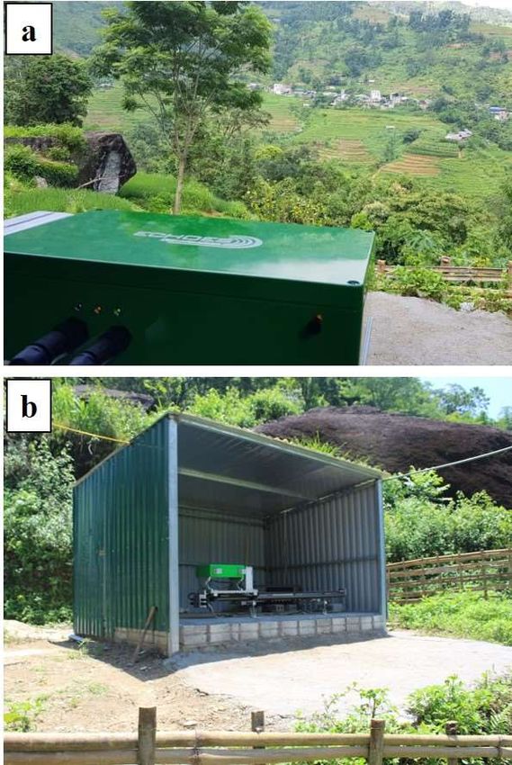
S. ROMEO, Q. C.TRAN, G. MASTRANTONI, D. DO MINH, D. DAO MINH, H. T. NGUYEN, D. A. NGUYEN & P. MAZZANTI

                                                                                             granite with gneissose texture; phase 2 is represented by medium
                                                                                             grained two-mica granite, biotitegranite. Moreover, the upper
                                                                                             part of the bedrock has been strongly weathered, whereas, at the
                                                                                             bottom, the bedrock acts as an aquiclude (QUOC ANH et alii,
                                                                                             2017). The thickness of the weathering layer is approximately
                                                                                             from 1-3 m to 10-20 m including four levels: i) Fine sand layer
                                                                                             with highly organic soils, ii) Clayey sand, iii) Poorly graded
                                                                                             gravel with boulders, iv) Granitoid – gneiss rock with many
                                                                                             cracks (Fig. 4a). Due to this weathering layer, shallow landslides
                                                                                             often occur along the grooves that dissected these slopes. In
                                                                                             addition, the diffused man-made rice terraces, saturated by
                                                                                             water, drastically reduce the stability conditions (DAO MINH et
                                                                                             alii, 2018).
       Fig. 3 - a) Damaged structure in Nam Dan market; b) cracking wall
                in a private house nearby the Nam Dan market (pictures
                                                                                                  The landslide occurred in July 2012 after one-week heavy
                taken by authors on 17th October 2019)                                       rain. In August 2013, the landslide was still active, causing
                                                                                             serious damages to 5 houses, Tan Son market and provincial
     people are living on the body and foot of the landslide increasing                      road n. 178. In the middle of the landslide body is the central
     the exposure of people and assets. In detail, farmers have                              market where local residents concentrated with high density
     transformed ground into terraced fields for rice and corn crops.                        every weekend.
                                                                                                  This indicates a high level of risk as the landslide may lead
                                                                                             to huge damage of both people and properties. The Nam Dan
     The Nam Dan landslide
                                                                                             landslide is an old translational debris slide (VARNES, 1978) and
         According to recent field surveys and observations, the
                                                                                             some evidence of reaction are clearly visible. On the landslide
     landslide covers an area of about 12,000 m2 with an average deep
                                                                                             body, there are some gully erosion creating holes with 1.5 - 2 m
     of about 22.5 meters based on drilling data (total volume of
                                                                                             depth, 6 m diameter on average. Those can be considered as
     about 270,000 m3). The surface of rupture is represented by the
                                                                                             ponds pounding over flow water, leading to internal erosion of
     weathered soil and bed rock interface (Fig. 4).
                                                                                             materials on the landslide body.
         The slope, the angle of which varies from 26° to 45° degrees,
     developed on anigneous bedrock belonging to Chay River                                       It is also important to point out that, in the surrounding of
     complex, the largest igneous rock formation in Vietnam. The                             the study area, old deep-seated landslides have been detected in
     Chay River is divided into two main phases: the phase 1 consists                        Ban Diu, Nam Dan, Che La, Quang Nguyen and Trung Chinh
     mainly of porphyroid granite, medium to big- grained two-mica                           areas (DAO MINH et alii, 2018, HUE et alii, 2015).

     Fig. 4 - a) Engineering geological cross section of Nam Dan landslide with monitoring instruments installed; b) Location map of Nam Dan landslide
              with monitoring instruments installed

58   Italian Journal of Engineering Geology and Environment, 1 (2020)   © Sapienza Università Editrice                                    www.ijege.uniroma1.it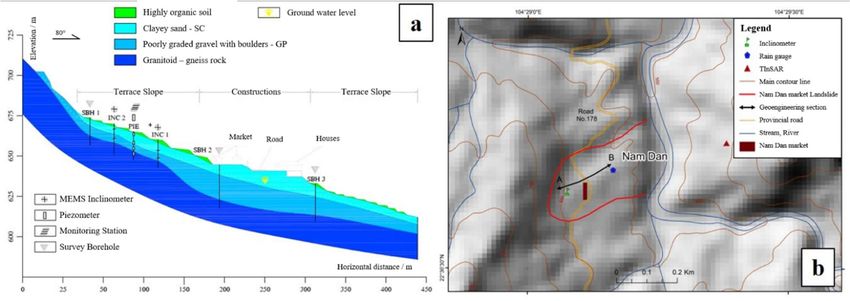
REMOTE MONITORING OF NATURAL SLOPES: INSIGHTS FROM THE FIRST TERRESTRIAL INSAR CAMPAIGN IN VIETNAM

METHODS                                                                                     Four-months monitoring of the Nam Dan village was carried
     In the framework of a research project coordinated by the                          out from the opposite side of the valley (about 500 m away in
Institute of Geological Sciences (IGS – VAST), an intensive                             Line of Sight), where an ad-doc shelter for the protection of
monitoring campaign through a remote sensing technique for the                          TInSAR system was realized (Fig. 5).
monitoring of displacements was carried out, thanks to the
collaboration of local authorities, between August and                                   Scan Length [m]                                          1.32
December 2019. A Terrestrial SAR Interferometer (TInSAR)                                                         Range [cm]                        50
was installed in the Municipality of Nam Dan, allowing to                                Spatial Resolution
                                                                                                                 Cross Range [deg.]               0.48
supply a deformation map of the natural slope, with related
displacement time series for each pixel, without the necessity of                        Operating Range [m]                                    2 - 1200
positioning targets on the ground (BOZZANO et alii 2010;                                 Central Frequency [GHz]                                  13.7
MAZZANTI 2015). This project represents the first monitoring                             Bandwidth [MHz]                                           300
campaign in the Country by using the “non-contact” TInSAR
                                                                                         Scan Time [s]                                             10
technique for landslide monitoring and assessment.
     The Terrestrial SAR Interferometry (TInSAR) is a ground-                            Polarization                                         Horizontal
based radar technique that allows to remotely perform real-time
                                                                                         Acquisition mode                                  Continuous SAR
monitoring of ground deformations, reaching sub-millimeter
                                                                                        Tab. 1 - Technical specifications of TInSAR equipment (Phoenix by
accuracy under ideal conditions (e.g. short distance, high wave
                                                                                                 Echoes Technologies S.r.l.)
reflection, etc.). This technique is based on an active radar
sensor, traversing a linear rail, that emits and receives
electromagnetic waves in the Ku band (12–18 GHz) measuring
the reflected signal (ANTONELLO et alii, 2004; Luzi et alii, 2010).
By comparing the phase difference of two or more SAR images,
collected at different times, the displacement along the
instrument Line of Sight (LoS) can be estimated. Compared to
Satellite InSAR, which is capable of monitoring large areas
characterized by slow movements, Terrestrial InSAR is more
suitable for the detailed and continuous monitoring of small
areas (e.g. natural slopes, rock wall, structures, bridges). The
latter is also useful to monitor area characterized by both slow
and rapid movements. In order to perform TInSAR monitoring,
the equipment should be installed in a stable location with a
panoramic view of the area to be investigated. Due to the high
data sampling rate and the 24/7 operability, under any weather
and lighting conditions, this technique is particularly suitable for
continuous monitoring of natural hazards.
     The present study was performed by using a new TInSAR
equipment called Phoenix, developed by the company Echoes
Technologies S.r.l. (https://www.echoes-tech.it/). Phoenix is an
active terrestrial Synthetic Aperture Radar (SAR) that synthesize
its antenna by moving along a suitable rail (Tab. 1). Transmitted
microwaves have a central frequency of 13.7 GHz (Ku-band).
Thanks to its continuous SAR acquisition mode, Phoenix can
collect a single radar image in less than ten seconds, allowing an
extremely short time interval between two consecutive
acquisitions. However, it has been decided to set up a                                  Fig. 5 - a) in the foreground, TInSAR Phoenix device, in the
measurement time interval equal to 5 minutes, making data                                        background the village of Nam Dan (about 500 m in line of
                                                                                                 sight); b) Shelter realized ad-hoc for the protection of TInSAR
transfer sustainable due to the long-term monitoring period.                                     system (pictures taken by authors on August 2019)

Italian Journal of Engineering Geology and Environment, 1 (2020)   © Sapienza Università Editrice                                         www.ijege.uniroma1.it    59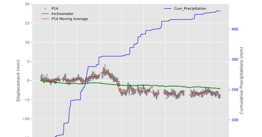
S. ROMEO, Q. C.TRAN, G. MASTRANTONI, D. DO MINH, D. DAO MINH, H. T. NGUYEN, D. A. NGUYEN & P. MAZZANTI

         The Nam Dan village and its surrounding are located in a                            of the structures and buildings displacements (TInSAR) as well
     remote area with few roads and urban settlements. In this                               as the rice terraces (TInSAR) and weathered layer
     context, installing the equipment and ensuring its full                                 (Inclinometer).
     functionality was a challenging aspect that committed a multi-                              In order to obtain these results, as part of Terrestrial SAR
     disciplinary team from Italy and Vietnam. The radar equipment                           monitoring, 15 points of interest (monitoring points), which
     was installed in a monitoring platform, with power supply,                              basically correspond to the main buildings (Fig. 6), were chosen
     realized ad-hoc for the protection of TInSAR system and fenced                          from the whole radar map selecting only the most reliable pixels
     to avoid animal disturbance. An IP camera was also installed for                        showing high Signal to Noise Ratio (SNR) paired with high level
     the continuous control of the TInSAR status. A high-speed                               of reflectivity.
     mobile internet modem was provided for the remote control of                                On August 10th, the TInSAR unit was set to continuously
     the system and data transfer to the Data Processing Center. Also,                       collect data (24/7) at an appropriate sampling rate (i.e. about 5
     NAS (Network Attached Storage) for the increasing of the local                          minutes) and to start the calibration phase aiming at optimizing
     data storage capacity was deployed. Due to the frequent                                 the acquisition and the processing parameters, also considering
     blackouts in the area, the monitoring platform was also equipped
                                                                                             the extreme atmospheric conditions due to the Southwest
     with a cabinet containing the electrical panel for the system
                                                                                             monsoon season. After four months of monitoring campaign,
     power supply, backup batteries and the laptop for the system
                                                                                             tens of thousands SAR images were acquired.
     control.
         Data acquired were processed by using a specific software                               During the entire SAR monitoring campaign, there were not
     (TRIVIA - Terrestrial Radar Interferometry Visualization and                            detected significant movements both on the structures of the
     Analysis) developed by the company NHAZCA S.r.l., in order                              public market and on the buildings in the village of Nam Dan.
     to perform advanced analyses of Terrestrial SAR images                                  This was also confirmed by contact instruments installed on the
     providing useful information to support the monitoring project.                         landslide. The displacement measured by the inclinometers and
     In detail, by comparing the phase difference of each pixel of                           the excess pore pressure recorded by piezometers did not register
     consecutive SAR images collected at different times, the                                any anomaly.
     displacement along the instrument Line of Sight (LoS) was                                   Displacement time series of the monitoring points show
     derived.                                                                                stable behaviour with deformations close to the instrumental
         A processing algorithm, based on Ground Control Points                              accuracy. Some time series related to interest points in
     (GCPs) identified by an expert user, was applied for the                                correspondence with metal structures/roofs, have shown daily
     atmospheric model determination. Also, for the atmosphere                               cyclical movements due to thermal expansion of materials.
     correction an interpolation method based on GCPs values along                               Fig. 7 shows, as an example, the displacement time series of
     range was used.                                                                         P14 (red lines),which corresponds to the head of the borehole
         In addition to the recent surface monitoring of displacement
                                                                                             (IPI1) where the inclinometer was placed at 6.8 m depth. In this
     through TInSAR technique, in the latest years fixed-in-place
                                                                                             sector of the vegetated slope, high-quality radar parameters due
     inclinometer probes and pore water pressure sensors were
                                                                                             to high-reflective target (i.e. solar panel) allowed to set a reliable
     installed in the Nam Dan landslide allowing to investigate in
     depth the evolution of the process (DAO MINH et alii, 2018). In                         monitoring point. The time series related to the inclinometer is
     detail, four inclinometers (Geokon MEMS Model 6155) were                                reported in green while cumulative precipitation is shown in
     installed in two different boreholes: 6.8 m and 12 m depth in                           blue. Thanks to this spatial matching it was possible to compare
     borehole n. IPI1; 2.8 m and 8 m depth in borehole n. IPI2.                              the behaviour of surface organic soil with the underlying clayed
         Also, four piezometers (Geokon Model 4500S) were                                    sands. The TInSAR related time series shows a fairly stable
     installed in a single borehole (BH1) at various depths: 1.5 m, 6                        behaviour during the four months of monitoring except for the
     m, 10.5 m and 13 m (Fig. 4). Results from this surveys and                              end of September 2019, when in few days a displacement of -6
     monitoring activities in depth allowed comparing recent data in                         mm towards the radar sensor was recorded. Concerning to the
     surface acquired by TInSAR technique, also taking into account                          inclinometer time series, it was characterized by a very slow and
     local meteorological conditions, monitored by a rain gauge                              continuous displacement, which lead to a cumulative
     deployed in Nam Dan area (22°36,823' N, 104°29,105' E).                                 displacement of 2 mm in four months.

     RESULTS                                                                                 FINAL REMARKS
         In the present case study, the integration of both remote                              The main details and results deriving from the first
     sensing and contact measurements have led to the quantification                         monitoring campaign through Terrestrial SAR Interferometry

60   Italian Journal of Engineering Geology and Environment, 1 (2020)   © Sapienza Università Editrice                                       www.ijege.uniroma1.it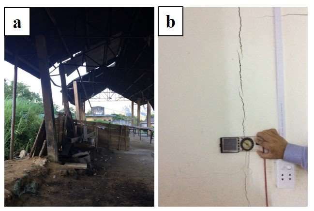
REMOTE MONITORING OF NATURAL SLOPES: INSIGHTS FROM THE FIRST TERRESTRIAL INSAR CAMPAIGN IN VIETNAM

Fig. 6 - a) Image of the investigated scenario with monitoring points in evidence; b) map of thermic SNR (Signal to Noise Ratio) with monitoring points.
         In the lower part of the SNR map (300-500 m in range) the rice terraces reported in Fig. 2 and Fig. 6a are clearly identifiable

(TInSAR) in Vietnam have been presented. On-field operational                               Although no significant evidence of movement was recorded
activities and the identification of technological solutions                            in the monitored period, the use of such innovative technology
represented particularly challenging aspects for the landslide                          (TInSAR) coupled with contact monitoring instruments
monitoring using remote sensing techniques.                                             (inclinometers, piezometers, rain gauge) and field surveys have
These aspects are particularly important considering the                                contributed to improving the knowledge about the Nam Dan
environmental conditions of the area, such as the remoteness and                        landslide and the understanding of its behaviour, with particular
the severe climatic conditions. The present study was carried out                       regard to the time evolution of displacements. As already shown,
by using Phoenix, a new Terrestrial SAR device developed by                             during the period of observation, in addition to daily cyclic
the Italian company Echoes Technologies S.r.l. This monitoring                          movements due to thermal expansion of specific materials, only
campaign has represented one of the first applications on-field                         limited deformations were registered close to the instrumental
for such an instrument.                                                                 accuracy.

Italian Journal of Engineering Geology and Environment, 1 (2020)   © Sapienza Università Editrice                                    www.ijege.uniroma1.it   61
S. ROMEO, Q. C.TRAN, G. MASTRANTONI, D. DO MINH, D. DAO MINH, H. T. NGUYEN, D. A. NGUYEN & P. MAZZANTI
Fig. 7 - Displacement time series of monitoring point n. 14 recorded by TInSAR (in grey) with moving average (in red), displacement time series recorded
by inclinometer placed on the landslide (in green), cumulative precipitation (in blue) for the whole monitoring period (from 10th August to 4th
December 2019)
With regard to the use of different monitoring instruments, However, this increment in deformation rate does not occur in
some considerations can be made: the underlying clayed sand, suggesting a localized
- compared to other monitoring tools, the use of TInSAR deformation process which involves only the upper part of the
technique (scan interval of 5 min) allowed the acquisition of a organic soil.
considerable number of data, useful to properly investigate the In conclusion, results achieved in the present monitoring
behaviour of the landslide; campaign, in combination with the previously acquired data,
- the integration of TInSAR and inclinometer displacements also from field surveys, suggest that the current slope is
data have allowed monitoring both the surface and in-depth predisposed to instability, which can be triggered by the first
displacements; severe rainfall during the early summer season.
- comparing data derived from the Terrestrial SAR with the
inclinometers data, it seems that at the end of September the ACKNOWLEDGEMENT
surface organic soil at the highest part of the slope (around This paper has been prepared in the framework of the
P14) could be subjected to a sudden increase in the research project “Fundamental research and propose early-
deformation rate, which in this case it was not related to warning solution for landslide, flash flood – debris flood in
rainfall occurrence. North of Vietnam by remote sensing technology and geology
62 Italian Journal of Engineering Geology and Environment, 1 (2020) © Sapienza Università Editrice www.ijege.uniroma1.itView publication stats
REMOTE MONITORING OF NATURAL SLOPES: INSIGHTS FROM THE FIRST TERRESTRIAL INSAR CAMPAIGN IN VIETNAM
data” funded by Vietnamese Space Science & Technology Uni. of Science, to support Geotechnical monitoring data at the
Program (project code VT-UD.05/18-20). We would like to Nam Dan landslide.
thank the Programme “Capacity Building and Technology We also thank researchers at Centre for Remote Sensing &
Transfer for Mitigation of Geo-hazards in Vietnam in the Geomatic (VTGEO), IGS, VAST, local authorities and local
Context of Climate Change.” code SRV-10/0026, run by VNU people to help us deploy TInSAR campaign at study area.
REFERENCES
AHLHEIM M., FRÖR O., HEINKE A., KEIL A., MINH DUC N., VAN DINH P., SAINT-MACARY C. & ZELLER M. (2008) - Landslides in mountainous regions of
Northern Vietnam: Causes, protection strategies and the assessment of economic losses. DiskussionspapiereausdemInstitutfürVolkswirtschaftslehre der
Universität Hohenheim 298/2008, Department of Economics, University of Hohenheim, Germany.
ANTONELLO G., CASAGLI N., FARINA P., LEVA D., NICO G., SIEBER A.J.&TARCHI D. (2004) - Ground-based SAR interferometry for monitoring
massmovements. Landslides 1: 21–28.
BOZZANO F., MAZZANTI P., PRESTININZI A. & SCARASCIA MUGNOZZA G. (2010) - Research and development of advanced technologies for landslide hazard
analysis in Italy. Landslides 7 (3): 381–385.
DAO MINH D., TRAN QUOC C., DO MINH D. & DANG THI T. (2018) -Analyze of pore water pressure and slope displacement by historical rain series in Xin
Man district, Ha Giang province, Vietnam. The 4th International Conference VIETGEO 2018: Slope stability and prediction.
DI MATTEO L., ROMEO S. & KIEFFER D.S. (2016) - Rock fall analysis in an Alpine area by using a reliable integrated monitoring system: results from the
Ingelsberg slope (Salzburg Land, Austria). Bull. Eng. Geol. Environ. (2017) 76: 413–420.
HUE T. T. (2015) - Studying and forecasting the phenomenon of landslide and provides prevention solution for Coc Pai town, Xin Man district, Ha Giang
province. Project report 08.33/06-10.
LUZI G. (2010) -Ground based SAR interferometry: a novel tool for geoscience. Geoscience and Remote Sensing: New Achievements, 1–26.
MAZZANTI, P. & CIPRIANI, I. (2011) - Terrestrial SAR interferometry monitoring of a civil building in the city of Rome. In FRINGE 2011’Workshop on
ERS/Envisat SAR Interferometry, ‘FRINGE11’, Frascati, Italy (p. 8).
MAZZANTI P., BOZZANO F., BRUNETTI A., ESPOSITO C., MARTINO S., PRESTININZI A., ROCCA A. & SCARASCIA MUGNOZZA G. (2015) -Terrestrial SAR
interferometry monitoring of natural slopes and man-made structures. In: LOLLINO G. et al. (eds) Engineering geology for society and territory, vol 5.
Springer International Publishing, Switzerland, 189–194.
NGOC D.M., THUY D.T. & DUC D.M. (2016) - Application of GIS and analytic hierarchy process for mapping landslide risks at Xin Man district, Ha Giang
province, Vietnam. VNU J Sci: Earth Environ Sci. 32 (2S): 206–216 [Vietnamese].
PHAM N.T.T., NONG D., SATHYAN A.R. & GARSCHAGEN M. (2020) - Vulnerability assessment of households to flash floods and landslides in the poor
upland regions of Vietnam. Climate Risk Management 28, 100215.
QUOC ANH G., DUC-TAN T., DINH CHINH N., VIET HA N. & DIEU TIEN B. (2017) -Design and implementation of site-specific rainfall-induced landslide
early warning and monitoring system: a case study at Nam Dan landslide (Vietnam). Geomatics, Natural Hazards and Risk, (8) 2.
ROMEO R., KIEFFER D. S. & DI MATTEO L. (2014) - The Ingelsberg landslide (Bad Hofgastein, Austria): description and first results of monitoring system
(GBInSAR technique). Rendiconti Online Società Geologica Italiana 32, 24–27.
VARNES D.J. (1978) - Slope movement and types and processes. In SCHUSTER, R. L. and KRIZEK R. J. (eds), Landslides: Analysis and Control. Special
Report 176, Washington, DC: National Academy of Sciences, 11–33.
Received May 2020 – Accepted June 2020
Italian Journal of Engineering Geology and Environment, (2020) © Sapienza Università Editrice www.ijege.uniroma1.it 63Puoi anche leggere