LE PRATERIE DI POSIDONIA COME MAGAZZINI DI CARBONIO DEL MEDITERRANEO - POSIDONIA OCEANICA MEADOWS AS CARBON SINKS OF THE MEDITERRANEAN SEA
←
→
Trascrizione del contenuto della pagina
Se il tuo browser non visualizza correttamente la pagina, ti preghiamo di leggere il contenuto della pagina quaggiù
L I F E17 C C M / I T/ 0 0 0 12 1

   LE PRATERIE DI POSIDONIA
        POSIDONIA OCEANICA MEADOWS
COME MAGAZZINI DI CARBONIO
               AS CARBON SINKS
   DEL MEDITERRANEO
          OF THE MEDITERRANEAN SEA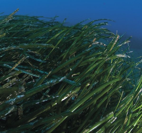
SeaForest LIFE
Pubblicazione a cura di
Pubblication edited by
Matteo Ruocco

Coordiatore del Progetto SeaForest LIFE
Coordinator of SeaForest LIFE project
D.R.E.Am. - Italia

Layout and printing
Arti Grafiche Cianferoni
Pratovecchio Stia (Arezzo)
www.cianferoni.com

Stampato su carta riciclata Lenza Top Recycling
Printed on Lenza Top Recycling recycled paper

Le 500 copie realizzate grazie a questo tipo di carta hanno permesso
di evitare l’emissione in atmosfera di oltre 100 kg di CO2
The 500 copies made thanks to this type of paper have allowed to
avoid the emission into the atmosphere of over 100 kg of CO2

Questo prodotto è stato realizzato grazie al contributo finanziario del
programma LIFE dell’Unione Europea
This product was created thanks to the financial contribution of the
LIFE program of the European Union
Contenuti / Contents
Il programma LIFE / The LIFE programme
Il progetto / The project
Aree di studio / Study areas
Il posidonieto / The Posidonia oceanica meadows
Il piano degli ormeggi / The mooring management plan
Il mercato dei crediti di carbonio / The carbon market

                                             SeaForest LIFE ■ 3 ■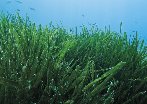
Il programma LIFE
The LIFE programme
Il Programma LIFE è lo strumento finanziario dell’Unione Eu- The LIFE Programme is the financial instrument of the Euro-
ropea per il sostegno di progetti ambientali, di protezione pean Union for the support of environmental projects, nature
della natura e di azioni per il clima in tutta l’UE. Dal 1992 protection and climate actions across the EU. Since 1992,
LIFE ha cofinanziato oltre 4000 progetti, contribuendo con LIFE has co-funded over 4000 projects, contributing around
circa 3,4 miliardi di euro per la protezione dell’ambiente e 3.4 billion euros for environmental and climate protection.
del clima. The overall objective of LIFE is to contribute to the implemen-
L’obiettivo generale di LIFE è contribuire all’attuazione, all’ag- tation, updating and development of the EU’s environmental
giornamento e allo sviluppo della politica ambientale e cli- and climate policy and legislation for the co-financing of pro-
matica dell’UE e alla legislazione per il cofinanziamento di jects with European added value.
progetti con un valore aggiunto europeo. The overall objective for the period 2014-2020 is to contrib-
L’obiettivo generale per il periodo 2014-2020 è contribuire ute to the sustainable development and achievement of the
allo sviluppo sostenibile e al raggiungimento degli obiettivi objectives and targets of the “European 2020 Strategy”, and
e traguardi della “Strategia Europea 2020” e delle strategie of the strategies and plans of the European Union concerning
e piani dell’Unione Europea riguardanti l’ambiente e il clima. the environment and the climate.
Il Sottoprogramma “Ambiente” prevede tre settori di azione The “Environment” sub-programme includes three priority
prioritari: areas of action:
■■ Ambiente ed uso efficiente delle risorse ■■ Environment and efficient use of resources
■■ Natura e Biodiversità ■■ Nature and Biodiversity
■■ Governance ambientale e informazione in materia am- ■■ Environmental governance and environmental information
bientale
Il Sottoprogramma “Azione per il clima” prevede tre settori The “Climate Action” sub-programme includes three priority
prioritari: areas:
■■ Mitigazione dei cambiamenti climatici ■■ Mitigation of climate change
■■ Adattamento ai cambiamenti climatici ■■ Adaptation to climate change
■■ Governance in materia climatica e informazione in materia ■■ Governance in climate and climate information
di climatica
SeaForest LIFE rientra del sottoprogramma “Azioni per il SeaForest LIFE falls under the “Climate Actions” sub-pro-
clima”, in particolare nel sottoprogramma “Mitigazione dei gramme, in particular in the sub-programme “Climate
cambiamenti climatici.” change mitigation.”
Il sottoprogramma Ambiente e Azione per il clima (LIFE) per il The Environment and Climate Action sub-programme (LIFE)
periodo 2014-2020 si basa sulla fornitura di soluzioni e buo- for the period 2014-2020 is based on the provision of solu-
ne pratiche per conseguire gli obiettivi ambientali e climatici tions and best practices to achieve environmental and cli-
in relazione ai cambiamenti nello sviluppo e nella politica e mate objectives concerning changes in development and
promuovendo tecnologie innovative nel campo dell’ambiente policy and by promoting innovative technologies in the field
e cambiamento climatico. of environment and climate change.
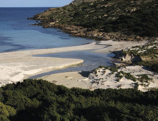
Capo Palinuro nel Parco Nazionale
del Cilento, Vallo di Diano e Alburni
Capo Palinuro in the Cilento, Vallo di
Diano and Alburni National Park
■ 4 ■ SeaForest LIFE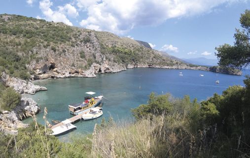
Il progetto
      The project
Il progetto ha come obiettivo generale        The project has, as generic objective,
l’incremento della capacità dei serbatoi      the increase of the capacity of the car-
di carbonio delle praterie di Posidonia,      bon reservoirs of Posidonia meadows
attraverso azioni di riduzione del de-        through erosion reduction and sub-
grado e successivo consolidamento             sequent consolidation of the habitat
dell’habitat 1120*: Praterie di Posidonia,    1120*: Posidonia meadows.
peraltro già protetto da convenzioni eu-      In particular the specific objectives are:
ropee.                                        (1) to quantify carbon deposits and cap-
Gli obiettivi specifici sono: (1) quantifi-   ture rates of phanerogams meadows
care i depositi di carbonio e i tassi di      habitat; (2) to analyze future develop-
sequestro degli habitat di prateria di        ments, carbon loss ratio, potential car-
fanerogame; (2) analizzare i futuri svi-      bon fixation and accumulation rates;
luppi, dal tasso di perdita di carbonio       the relationship between carbon emis-
alla potenziale fissazione del carbo-         sion and sequestration in degradation
nio e i tassi di accumulo e analizzare il     and erosion formations; (3) to define
rapporto tra emissione e sequestro di         the standards for the evaluation of car-
carbonio nelle formazioni soggette a          bon dioxide of the phanerogams mead-
degradazione ed erosione; (3) definire        ows habitat; (4) Identify good practices
gli standard di valutazione dei serbatoi      for the defense of these formations and
di carbonio degli habitat; (4) identificare   their carbon sinks and their expansion;
buone pratiche per la difesa di queste        (5) to stimulate dialogue at national
formazioni e dei loro serbatoi di carbo-      level to activate a network of compa-
nio e per il loro ampliamento; (5) inco-      nies and organizations involved in the
raggiare il dialogo a livello nazionale per   carbon trading market; (6) to engage
attivare una rete di aziende e organiz-       the network of Italian marine protect-
zazioni coinvolte nel mercato del carbon      ed areas, in order to promote transfer
trading; (6) coinvolgere la rete delle Aree   projects of the technical results.
Marine Protette italiane al fine di pro-      The Posidonia meadows habitat is re-
muovere progetti di trasferimento dei         vealing to be significant in terms of car-
risultati tecnici conseguiti.                 bon sinks, both in terms of intensity of
L’habitat delle praterie di Posidonia è       carbon sequestration and in the capac-
infatti significativo per quanto concer-      ity of its deposits, which are accumulat-
ne i depositi di carbonio, sia in termini     ing carbon for thousands of years.
di intensità del sequestro del carbonio,      Posidonia meadows represent a very
sia per la capacità dei suoi depositi, il     important ecosystem from many points
cui accumulo prosegue da migliaia di          of view. In fact the habitat not only play
anni. Le praterie rappresentano un            a primary role as oxygen producers
ecosistema importantissimo da molti           (producing up to 16 liters of oxygen per
punti di vista: oltre a svolgere un ruolo     square meter) and as a carbon stocker
primario sia come produttori di ossige-       (by storing 50% of the carbon buried in
no (arrivando a produrre fino a 16 litri      marine sediments, twice the land for-
circa di ossigeno per metro quadro),          ests), but it also plays an important role
sia come deposito di carbonio (imma-          as nurseries for many species of marine
gazzinando il 50% del carbonio sepol-         organisms. Despite the importance of
to nei sedimenti marini, il doppio delle      this ecosystem service, even regarding
foreste terrestri), esse svolgono un’im-      the biodiversity which it hosts, this hab-
portantissima funzione di nursery per         itat is disappearing at a rate four times
moltissime specie di organismi marini.        as high as that of terrestrial forests.
Nonostante l’importanza di questo ser-
vizio ecosistemico, anche dal punto di
vista della biodiversità che esso ospi-
ta, questo habitat sta diminuendo ad
un tasso che è quattro volte più alto di
quello delle foreste terrestri.

                                                                                           SeaForest LIFE ■ 5 ■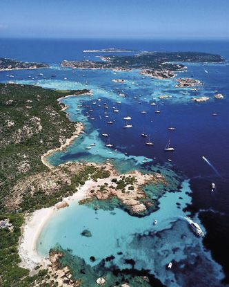
Cala Arena nel Parco Nazionale dell’Asinara
                                                                                                Cala Arena in the Asinara National Park
                                                                                                                    (by Domenico Ruiu)

Inquadramento geografico delle aree di studio del progetto
Geographical overview of the study areas of the project

Aree di studio
Il progetto si realizza nel Parco Nazionale dell’Arcipelago de la Maddalena, nel Parco Nazionale
dell’Asinara e nel Parco Nazionale del Cilento, Vallo di Diano e Alburni. In un secondo momento
il modello SeaForest LIFE verrà esportato a Malta.

Parco Nazionale                                              Parco Nazionale                                 Parco Nazionale
dell’Arcipelago                                              dell’Asinara                                    del Cilento,
di La Maddalena                                                                                              Vallo di Diano e Alburni
Posto nelle acque dello stretto di Boni-                     È situato nella provincia di Sassari e          L’area naturale protetta di circa 36.000
facio, tra Sardegna e Corsica, si estende                    si estende su una superficie di circa           ha, interamente compresa nella provin-
su una superficie di circa 18.000 ha. Il                     5.200 ha. Il Parco comprende l’Area             cia di Salerno, è stata successivamente
Parco comprende tutta l’area marina                          Marina Protetta Isola dell’Asinara, che         estesa fino a portare la sua superficie
dell’Arcipelago di La Maddalena (13.000                      circonda l’Isola dell’Asinara e ha un’e-        a 181.048 ha. Dal 1998 è Patrimonio
ha) e quella terrestre (5.134 ha) di isole                   stensione di circa 108 km2, il SIC Isola        dell’umanità dell’Unesco (con i siti ar-
e isolotti appartenenti al territorio del                    dell’Asinara ITB010082 e la ZPS Isola           cheologici di Paestum e Velia e la Cer-
Comune omonimo per 180 km di co-                             Asinara ITB010001 della Rete Natu-              tosa di Padula), dal 1997 è Riserva della
ste. Include il SIC ITB010008 e la ZPS                       ra2000 europea.                                 biosfera e dal 2010 è il primo parco na-
ITB010008 della Rete Natura2000 eu-                                                                          zionale italiano a diventare Geoparco.
ropea.                                                                                                       Il parco comprende due Aree Marine
                                                                                                             Protette: l’Area Marina Protetta di San-
                                                                                                             ta Maria di Castellabate e l’Aria Marina
                                                                                                             Protetta Costa degli Infreshi e della
                                                                                                             Masseta, entrambe istituite nel 2009.
                                                                                                             Sono numerosi i siti della Rete Natu-
                                                                                                             ra2000 europea ricadenti all’interno di
                                                                                                             questa area protetta.

■ 6 ■ SeaForest LIFE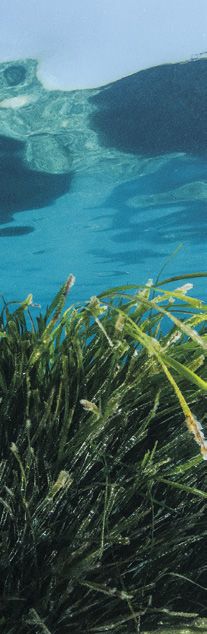
Study areas
The project is realized in the Archipelago of la Maddalena National Park, the Asinara National
Park and the Cilento, Vallo di Diano and Alburni National Park. In a second phase, the SeaForest
LIFE model will be exported to Malta.

Arcipelago                                  Asinara                                    Cilento, Vallo di Diano
of La Maddalena                             National Park                              and Alburni
National Park                                                                          National Park
Located in the waters of the Strait of      It is located in the province of Sassari   The protected natural area of about
Bonifacio, between Sardinia and Cor-        and it covers an area of approximately     36,000 ha, entirely included in the prov-
sica, it covers an area of about 18,000     5,200 ha. The Park includes the Marine     ince of Salerno, was subsequently ex-
ha. The Park includes the entire marine     Protected Area of Asinara Island, which    tended to bring its surface to 181,048
area of the La Maddalena Archipela-         surrounds the Island of Asinara and has    ha. Since 1998 it has been UNESCO
go (13,000 ha) and the terrestrial area     an extension of about 108 km2, the SCI     World Heritage Site (with the archaeo-
(5,134 ha) of islands and islets belong-    Isola dell’Asinara ITB010082 and the       logical sites of Paestum and Velia and
ing to the territory of the homonymous      SPA Isola Asinara ITB010001 of the Eu-     the Certosa di Padula), since 1997 it has
municipality for 180 km of coastline. Fi-   ropean Natura2000 Network.                 been a Biosphere Reserve and since
nally, it includes the SCI ITB010008 and                                               2010 is the first Italian national park to
the SPA ITB010008 of the European                                                      become a Geopark. The park includes
Natura2000 Network.                                                                    two Marine Protected Areas: the Ma-
                                                                                       rine Protected Area of Santa Maria di
                                                                                       Castellabate and the Protected Marine
                                                                                       Air Coast of the Infreshi and Masseta,
                                                                                       both established in 2009. Numerous
                                                                                       sites of the European Natura2000 Net-
                                                                                       work fall within this protected area.

                                                                                                               SeaForest LIFE ■ 7 ■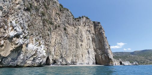
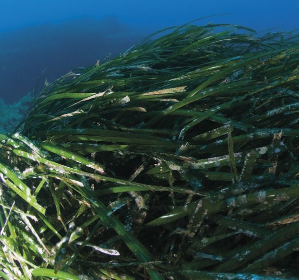
Il posidonieto
Il progetto LIFE prevede la quantificazione dei depositi di car-    lento. Questi dati si riferiscono a un unico giorno e il periodo
bonio e la stima del tasso di modifica in relazione al degra-       turistico (e ad alta frequentazione di imbarcazioni) nei Parchi
do dell’habitat dovuto agli impatti generati dagli ancoraggi        Nazionali del progetto varia dai 2 ai 3 mesi ogni anno. Il loro
e dagli ormeggi delle imbarcazioni da diporto. A riguardo è         impatto può dunque essere molto elevato se non vengono
stato realizzato, per ciascuno dei Parchi coinvolti nel pro-        correttamente gestiti gli attracchi.
getto, l’aggiornamento della cartografia dell’habitat 1120*         Le cartografie aggiornate dei posidonieti, per ciascuna area,
mediante l’ausilio di immagini satellitari multispettrali ad alta   sono state utilizzate per l’implementazione del modello In-
risoluzione. È stato inoltre svolto, mediante l’impiego di im-      VEST Coastal Blue Carbon che stima la quantità di carbonio
magini Multispettrali satellitari a media risoluzione usando la     sequestrato, stoccato e, in caso di disturbo, riemesso dagli
banda dell’infrarosso, un monitoraggio delle zone a maggiore        ecosistemi costieri. Inoltre, attraverso una stima monetaria
frequentazione degli ancoraggi al fine di individuare e quan-       e sociale, il modello quantifica il valore marginale del servizio.
tificare il degrado e lo stato di conservazione delle praterie      In questo contesto i risultati ottenuti possono sostenere gli
di P. oceanica presenti nelle aree di interesse del progetto.       stakeholders nell’identificazione di zone all’interno del pae-
Dai primi risultati è apparso evidente un elevato impatto da        saggio dove ridurre la degradazione e possibilmente incen-
parte delle imbarcazioni in aree particolarmente sensibili.         tivare la conservazione. Dai risultati preliminari su larga scala
Nell’area dell’Isola Piana, nel Parco Nazionale dell’Asinara, ad    nelle 3 aree di studio, è emerso come il tasso di accumulo del
esempio, si sono registrate 367 imbarcazioni censite analiz-        carbonio nella parte viva del posidonieto vari da 7.13 a 217 g
zando 4 scene temporali (16 e 26 di luglio, 10 e 15 di agosto       Corg/m2 /anno. Occorrono dunque circa 1400 ha di praterie
2019) di cui 70 ancoraggi su Posidonia oceanica. Solo 28 im-        degradate o circa 460 ha di praterie in buono stato di salute
barcazioni hanno avuto un basso impatto, mentre 202 im-             (es. Posidonia su matte e sabbia e Posidonia su roccia) per
barcazioni hanno avuto un impatto medio e 167 un impatto            produrre una tonnellata di Corg (credito di carbonio) in un
elevato.                                                            anno.
Per l’Arcipelago de la Maddalena sono state registrate 284
imbarcazioni nei giorni di massima affluenza per la sola area
di Porto della Madonna e 242 imbarcazioni nell’area del Ci-                                       Impatti degli ancoraggi sulle praterie di posidonia.
                                                                                         Impacts of anchorages on the Posidonia oceanica meadows.

■ 8 ■ SeaForest LIFE
The Posidonia oceanica meadows
The SeaForest Life project foresees the quantification of car-                              Mappa preliminare dell’estensione
                                                                                            del posidonieto nel Parco
bon deposits and their rate of change related to habitat deg-                               Nazionale dell’Asinara.
radation due to pleasure boat’s anchors and moorings. To this                               Preliminary map of the extension
                                                                                            of the Posidonia oceanica meadows
aim, an updating of habitat 1120*’s cartography in each of the                              in the Asinara National Park.
Marine Protected Areas engaged in the project have been ful-
filled, using high-definition multispectral imagery.
Furthermore, monitoring of the areas with the highest attend-
ance of the anchorages was carried out through the use of
medium resolution satellite multi-spectral images using the
infrared band, to identify and quantify the degradation and
the state of conservation of the Posidonia oceanica meadows
present in the areas of interest of the project.
From the first results, it appeared evident a high impact by the
boats in particularly sensitive areas. In the Isola Piana area, in
the Asinara National Park, for example, 367 boats have been
registered, analyzing 4-time scenes (16 and 26 of July, 10 and
15 of August 2019) of which 70 anchorages on Posidonia oce-
anica. Only 28 boats had a low impact, while 202 boats had a
medium impact and 167 a high impact.
For the Archipelago of La Maddalena National Park, 284 boats
were registered on days of maximum inflow for the area of
Porto della Madonna and 242 boats in the Cilento National
Park areas. These data refer to a single day and the tourist
period (and high attendance of boats) in the National Parks of
the project varies from 2 to 3 months each year. Their impact
can, therefore, be very high if docking is not properly managed.
The updated cartography of the Posidonia meadows has been
used to implement the InVEST Coastal Blue Carbon which at-
tempts to predict the sequestration, storage and, when de-
graded, the emissions of carbon by coastal ecosystems. Also,
using an estimate of the monetary, social value the model
quantifies the marginal value of this service.
In this context, InVEST results can help to identify locations
within the landscape where degradation should be avoided,                                   Mappa preliminare della stima
and restoration should be prioritized.                                                      degli stock di carbonio nel Parco
                                                                                            Nazionale dell’Asinara.
Preliminary results on a large scale in the 3 study areas showed                            Preliminary map of the estimate
that the carbon accumulation rate in the living portions of                                 of carbon stocks in the Asinara
                                                                                            National Park.
the seagrass meadow varies from 7.13 to 217 g Corg/m2/year.
Therefore, about 1400 ha of degraded grasslands and about
460 ha of grasslands in good state of health (eg Posidonia oce-
anica on matte and sand and Posidonia oceanica on rock) are
needed to produce a ton of Corg (carbon credit) in a year.

Identificazione delle zone d’impatto degli ancoraggi e valutazione del degrado dei
posidonieti intorno all’Isola Piana nel Parco Nazionale dell’Asinara.
Identification of the impact zones of the anchorages and assessment of the degradation of
the Posidonia oceanica meadows around the Piana Island in the Asinara National Park.

                                                                                                                                SeaForest LIFE ■ 9 ■
Il piano degli ormeggi
Le praterie di posidonia sono minaccia-           caratterizzazione di dettaglio dei fondali   piattaforma l’utente dovrà registrare i
te da numerosi fattori di stress, princi-         che sarà eseguita in siti di particolare     propri dati anagrafici, le caratteristiche
palmente legati alle attività antropiche.         interesse con l’ausilio di strumenti acu-    tecniche dell’imbarcazione, la data e il
La costruzione di porti, l’inquinamento,          stici ad alta risoluzione (MBES, SBP), si    periodo di permanenza nell’area.
la pesca a strascico, l’ancoraggio incon-         identificheranno le aree in cui sviluppa-    L’applicazione fornirà una mappa det-
trollato e altre attività antropiche pos-         re nuovi ormeggi, le aree in cui consen-     tagliata delle aree di ancoraggio libero
sono danneggiare la salute dell’Habitat           tire l’ancoraggio e le aree pertinenti in    disponibili presenti nelle vicinanze e/o,
1120* (Praterie di Posidonia oceanica).           cui applicare le misure di protezione.       laddove presenti, dei campi ormeggio,
Una delle azioni di SeaForest LIFE                La stesura di un piano degli ormeggi         e darà un’indicazione del tempo di per-
prevede la realizzazione di un pia-               dettagliato permetterà di ridurre sen-       manenza concesso (dipendentemen-
no di ges tione degli ormeg gi per                sibilmente gli effetti negativi degli an-    te dalle politiche gestionale dettate
r idur re l ’ imp a t to di que s t a p r a -     coraggi sulle praterie di Posidonia e di     dall’Ente gestore), in modo da consenti-
t i c a sulla p r a te r ia di p o si d o nia .   conseguenza sullo stoccaggio di carbo-       re una rotazione dell’utilizzo delle aree
I piani di gestione degli ormeggi sa-             nio.                                         tra tutti i fruitori dell’area.
ranno attuati in collaborazione con                                                            La piattaforma potrà integrarsi agli
gli enti gestori dei Parchi Naziona-              Allo scopo di rendere fruibile dagli uten-   eventuali sistemi di pagamento per il ri-
li che già sviluppano regole specifi-             ti il piano egli ormeggi verrà sviluppata    lascio delle autorizzazioni a disposizione
che per l’ormeg gio e l’ancorag gio.              una piattaforma informatica con annes-       dell’Ente o, in sua assenza, costituirne la
Grazie all’individuazione delle aree mag-         sa applicazione per dispositivi mobili. Il   struttura di gestione ex novo.
giormente frequentate dai natanti attra-          sistema informativo sarà utilizzabile da     Costituirà anche un sistema di interfac-
verso immagini satellitari, alle mappatu-         chiunque richieda un’autorizzazione di       cia per l’utente che potrà accedere ad
re degli Habitat dei fondali marini e alla        accesso all’area protetta. Attraverso la     informazioni sull’area, ricevere allerte
                                                                                               meteo o allerte nel caso la propria im-
                                                                                               barcazione si dovesse trovare in aree
                                                                                               di divieto di navigazione e di sosta o in
                                                                                               aree in cui sono previste specifiche mi-
                                                                                               sure di protezione. Attraverso il portale
                                                                                               si daranno informazioni all’utente in me-
                                                                                               rito al progetto e all’importanza di tute-
                                                                                               lare la Posidonia dando indicazione dei
                                                                                               principali servizi ecosistemici generati
                                                                                               dall’estensione della prateria protetta:
                                                                                               ossigenazione e stoccaggio della CO2.

                                                                                               Porto della Madonna nel Parco
                                                                                               Nazionale dell’Arcipelago di La
                                                                                               Maddalena
                                                                                               Porto della Madonna in the
                                                                                               Arcipelago of La Maddalena National
                                                                                               Park

                                                                                                  Il QR-Code rimanda direttamente
                                                                                                 al video “L’impatto degli ancoraggi
                                                                                                          sulle praterie di posidonia”,
                                                                                                realizzato dalla società Andromède
                                                                                                          Océanologie per conto dell’
                                                                                                      Office de l’Environnement de la
                                                                                                 Corse, nell’ambito del Programma
                                                                                                       di Cooperazione Italia Francia
                                                                                                      Marittimo 2014-2020, progetto
                                                                                                                  strategico GIREPAM.
                                                                                                 The QR-Code refers directly to the
                                                                                               video “The impact of anchorages on
                                                                                                  the Posidonia oceanica meadows”,
                                                                                                           created by the Andromède
                                                                                                Océanologie company on behalf of
                                                                                                    the Office de l’Environnement de
                                                                                                   la Corse, under the Interreg Italy-
                                                                                               France (Maritime) Programme 2014-
                                                                                                   2020, GIREPAM strategic project.

■ 10 ■ SeaForest LIFE
The mooring management plan
The Posidonia oceanica meadow is An IT platform will be developed with an oceanica, indicating the main ecosystem
threatened by various stressors, main- application for mobile devices to make services generated by the extension of
ly related to human activities. The har- the plan available by users. The infor- the protected seagrass meadows: oxy-
bour construction, pollution, trawling, mation system will be usable by anyone genation and storage of CO2.
the uncontrolled anchoring and other requesting an authorization to access
human activities can damage the health the protected areas. Through the plat-
of 1120* Habitat (Posidonia oceanica form, the user will have to register his/
meadow). her data, the technical characteristics
One of the actions of the SeaForest of the boat, the date and the period of
LIFE foresees the realization of a man- staying in the area.
agement plan of mooring to reduce the The application will provide a detailed
impact of this practice on the seagrass map of the available free anchor are-
meadows. as present in the vicinity and/or, where
The mooring management plans will be present, mooring fields, and will give an
implemented in collaboration with the indication of the time of permanence
managing bodies of the National Parks granted (depending on the manage-
that already developed specific rules ment policies dictated by the managing
for mooring and anchoring. body), in order to allow a rotation of the
Thanks to the identification of the are- use of the areas among all the users.
as more frequented by boats through The platform will be able to integrate
satellite images, the sea bottom habi- with any payment systems for issuing
tat maps and the characterization of authorizations available to the Entity
the sea bottom by using acoustic tools or, in its absence, to set up an ex novo
(MBES, SBP), areas were new moor- management structure.
ing could be developed, areas where It will also constitute an interface sys-
free anchorage could be allowed and tem for the user who will have access to
areas where protec tion measured information on the area, receive weath-
could be applied will be identified. er alerts or alerts if his boat is in areas
The drawing up of a detailed mooring where navigation and anchoring are
plan will significantly reduce the nega- prohibited or in areas where specific
tive effects of anchoring on the Posido- protection measures are provided.
nia oceanica meadows and consequent- The portal will give to the user infor-
ly on carbon storage. mation regarding the project and the Porto Infreschi nel Parco Nazionale
del Cilento, Vallo di Diano e Alburni
importance of protecting the Posidonia Porto Infreschi in the Cilento, Vallo di
Diano and Alburni National Park
SeaForest LIFE ■ 11 ■Il mercato dei crediti di carbonio
SeaForest LIFE promuoverà l’uso della “Il credito di carbonio è duzione delle emissioni prima di optare
Climate Finance per la conservazione e il per la compensazione delle emissioni
ripristino delle praterie di Posidonia oce-
una vera e propria unità rimanenti.
anica. Infatti, attualmente non esistono di carattere finanziario A tal proposito, per sviluppare un valore
meccanismi strutturati per valorizzare che rappresenta la rimo- aggiunto per le aziende, le società che
economicamente le riserve di carbonio zione di una tonnellata di acquistano i crediti di carbonio genera-
(“Blue carbon”) delle praterie di Posido- CO2 equivalente dall’atmo- ti dalle attività del progetto SeaForest
nia. Il meccanismo di “Carbon Market”, LIFE potranno utilizzare il marchio Sea-
ampiamente utilizzato per le attività di
sfera. Rappresenta il car- Forest per migliorare la propria reputa-
mitigazione del cambiamento climatico bonio che è stato evitato zione territoriale e inserirsi nei circuiti di
svolte nell’ecosistema terrestre, non o sequestrato e stoccato qualità promossi dalle Regioni all’inter-
prevede ancora la possibilità di mone- attraverso un progetto e no delle quali i crediti di carbonio sono
tizzare le riserve di carbonio nelle pra- che può essere acquistato stati generati.
terie di Posidonia. Il punto di forza del progetto SeaForest
Il progetto SeaForest LIFE creerà un
come mezzo per compen- LIFE è che riuscirà a creare e promuo-
mercato di scambi volontari di crediti di sare le emissioni.” vere un mercato locale in cui le aziende
carbonio appositamente generati dalle hanno la possibilità di compensare le
attività del progetto SeaForest LIFE. A aForest LIFE. Ciò garantirà che tutte le proprie emissioni attraverso attività di
tal fine, verrà creata una piattaforma riduzioni delle emissioni vendute siano riduzione e assorbimento delle emissio-
informatica a livello nazionale. Nella se- reali e misurate secondo un approccio ni di gas a effetto serra implementate
conda fase si prevede che la piattafor- scientifico comunemente approvato. nelle immediate vicinanze geografiche.
ma e il relativo “Carbon Market” potran- Anche le aziende che intendono com- Attraverso il semplice processo di acqui-
no essere estesi per coprire tutti i paesi pensare le proprie emissioni acquistan- sto di crediti di carbonio, le organizza-
del Mediterraneo e potranno essere do crediti di carbonio generati dalla zioni non solo contribuiscono a mitigare
inoltre adattati alle nuove aree marine conservazione e dal ripristino delle pra- i cambiamenti climatici, ma finanziano
protette. terie di Posidonia all’interno dei Parchi direttamente le attività di conservazio-
Per garantire l’integrità e la trasparen- nazionali coinvolti nel progetto, devono ne e restauro delle praterie di Posidonia
za, il nuovo mercato dei crediti di car- dimostrare di aver seguito l’approccio e contemporaneamente contribuiscono
bonio sarà ammissibile solo per i crediti delle migliori pratiche, ovvero di aver concretamente al raggiungimento degli
quantificati utilizzando la metodologia misurato le proprie emissioni (Carbon Obiettivi di sviluppo sostenibile (SDGs)
standardizzata creata dal progetto Se- Footprint) e di aver svolto attività di ri- stabiliti dalle Nazioni Unite.
CO₂ O₂
■ 12 ■ SeaForest LIFEThe carbon market
The SeaForest LIFE will enhance the est LIFE project for this purpose. This their emissions through activities re-
use of the Climate Finance for con- will ensure that all the sold emission ducing and absorbing the greenhouse
servation and restoration of Posidonia reductions are real and measured fol- gas emissions implemented within in
oceanica meadows. Currently there are lowing a commonly approved scientific the immediate geographical vicinity.
not yet structured mechanisms to val- approach. Through the simple process of pur-
orise economically the carbon stocks Also the companies willing to compen- chasing carbon credits, companies are
(“Blue carbon”) of Posidonia meadows. sate their emissions by purchasing not only helping to mitigate climate
Carbon Market mechanism which is carbon credits generated by conser- change but directly financing the con-
widely used for the climate mitigation vation and restoration of Posidonia servation and restoration activities of
activities made in the terrestrial eco- oceanica meadows within the National Posidonia oceanica meadows and con-
system is not yet including the possi- Parks involved in the Project needs to temporary contributing concretely to
bility to monetize the carbon stocks of proof that they have followed the best the achievement of the global Sustain-
Posidonia oceanica meadows. practice approach i.e. that they have able Development Goals (SDGs) set by
The SeaForest LIFE project will create measured their own emissions through UN.
a voluntary based carbon market for a carbon footprint and made reduction
selling and acquiring the carbon credits activities before opting for compensat-
generated by the SeaForest LIFE pro- ing the remaining emissions.
ject activities. For this purpose, a na- Regarding this, to develop an added
“Carbon credit is a financial
tional IT-based platform will be created. value to the companies, the compa-
In the second phase, the platform and nies buying the credits generated by unit that represents
carbon market approach is foreseen to the activities of SeaForest LIFE will be the removal of a ton of
be extended to cover all the Mediterra- able to use the SeaForest brand to im- CO2 equivalent from the
nean countries and to be eligible also prove their territorial reputation and atmosphere. It represents
to be scaled up to new the protected insert themselves in the quality circuits
the carbon that has been
marine areas. promoted by the Regions within which
the carbon credits are have been gen- avoided or sequestrated
To guarantee the integrity and trans- erated. and stocked through a
parency of the new carbon market The strength of the SeaForest LIFE pro- project and that can be
it will be eligible only for the credits ject is that will create and be promoting purchased as a means to
quantif ied using the standardized a local market where the companies
offset emissions.”
methodology created by the SeaFor- have the possibility to compensate
SeaForest LIFE ■ 13 ■Partners
D.R.E.Am. - Italia (coordinator) Water Right Foundation Parco Nazionale dell’Asinara
www.dream-italia.it www.wrf.it www.parcoasinara.org
Carbonsink Paragon Europe Parco Nazionale dell’Arcipelago
www.carbonsink.it/it www.paragoneurope.eu di La Maddalena
www.lamaddalenapark.it
Università degli Studi della Tuscia IAS - CNR
www.unitus.it Consiglio Nazionale delle Ricerche
www.cnr.it
ISPRA
Istituto Superiore per la Protezione e Parco Nazionale del Cilento, Vallo di
la Ricerca Ambientale Diano e Alburni
www.isprambiente.gov.it www.cilentoediano.it
Authors
Simone Bonamano [UNITUS] Marcello Miozzo [D.R.E.Am. - Italia] Matteo Ruocco [D.R.E.Am. - Italia]
Walter Brambilla [IAS CNR] Marina Pulcini [ISPRA] Simone Simeone [IAS CNR]
Ulla Mauno [Carbonsink] Francesco Rende [ISPRA] Vittorio Gazale [PN dell'Asinara]seaforestlife.eu
L I F E 17 C C M / I T/ 0 0 0 12 1Puoi anche leggere