The Pilato Lake (Sibillini Mts., Central Italy): first results of a study on the supposed variations of its hydrogeological conditions induced by ...
←
→
Trascrizione del contenuto della pagina
Se il tuo browser non visualizza correttamente la pagina, ti preghiamo di leggere il contenuto della pagina quaggiù

DOI: 10.7343/as-2019-409 IAH-“Flowpath 2019” - Paper
The Pilato Lake (Sibillini Mts., Central Italy): first results of a study on
the supposed variations of its hydrogeological conditions induced by
the seismic sequence 2016-2017
Il Lago di Pilato (Monti Sibillini, Italia centrale): primi risultati di uno studio sulle presunte
variazioni delle condizioni idrogeologiche indotte dalla sequenza sismica 2016-2017
Lucio Martarelli, Rossella Maria Gafà, Paolo Maria Guarino, Gennaro Maria Monti, Luca Maria Puzzilli, Angelantonio Silvi
Riassunto: Il Lago di Pilato è situato nei Monti Sibillini (Italia del basamento causate dallo scuotimento sismico, che potrebbe
Centrale), ha origine glaciale ed ospita l’endemismo del piccolo avere influenzato l’infiltrazione verso il sottosuolo. I bassi valori
crostaceo Chirocephalus marchesonii. Nell’ambito di una colla- di conducibilità elettrica delle acque del lago sono in accordo con
borazione di ricerca con il Parco Nazionale dei Monti Sibillini, il la prevalente provenienza della ricarica del lago dallo scioglimen-
Servizio Geologico d’Italia dell’ISPRA sta eseguendo alcuni stu- to della neve e dalle precipitazioni. Per quanto concerne le prime
di finalizzati alla valutazione dei presunti effetti della sequenza indagini geofisiche nell’area del lago, i rilievi sismici eseguiti con
sismica dell’Italia Centrale del 2016–2017 sulle condizioni idro- il metodo delle onde superficiali hanno permesso di stimare che
geologiche che controllano l’evoluzione del lago. il massimo spessore dei detriti è di circa 12.5-14 m.
Lo studio, iniziato nel luglio 2018, è stato preliminarmente fina- In conclusione, lo sfioro delle acque attraverso la Fonte del Lago,
lizzato alla ricostruzione dell’assetto geologico ed idrogeologico l’evaporazione dalla superficie del lago ed il processo di drenance
del sottosuolo nell’area della valle che ospita il lago. Sono state attraverso i depositi glaciali scarsamente permeabili verso l’Ac-
eseguite indagini idrogeologiche e geofisiche per poter defini- quifero calcareo basale, che si trova nei depositi carbonatici a
re un modello concettuale della circolazione idrica sotterranea e quote inferiori, sono responsabili della progressiva diminuzione
per valutare i cicli stagionali di svuotamento e riempimento del dei livelli del lago nel tempo.
lago. Il programma delle ricerche è tuttora in corso ed al mo-
mento saranno presentati solo alcuni risultati preliminari. Abstract: The Pilato Lake has glacial origin, is located in the Sibil-
I rilievi idrogeologici hanno dimostrato l’assenza di evidenze lini Mountains, Central Italy, and is characterized by the endemism
geomorfologiche di fratture sismiche e quindi il completo es- of the small crustaceous Chirocephalus marchesonii. In the context of a
siccamento del lago avvenuto nell’estate 2017 è stato probabil- research agreement with the Monti Sibillini National Park, the ISPRA
mente dovuto a ragioni meteoclimatiche e/o ad una non ancora Geological Survey of Italy is carrying on some studies aimed to evaluate
verificata variazione di permeabilità dei depositi superficiali e/o the supposed effects of the 2016–2017 Central Italy earthquakes on the
hydrogeological conditions controlling the lake’s evolution.
The study, started in July 2018, aims primarily at the reconstruction
Keywords: hydrogeology, hydrogeological conceptual model, Pilato Lake, of the geological and hydrogeological subsoil setting, beneath the valley
Sibillini Mts., Central Italy. hosting the lake. In order to define the conceptual model of groundwater
circulation and, thus, to evaluate the emptying and recharge seasonal
Parole chiave: idrogeologia, modello idrogeologico concettuale, cycle of the lake, hydrogeological surveys and geophysical investigations
Lago di Pilato, Monti Sibillini, Italia centrale. were performed. The research program is still in progress and only pre-
liminary results may be proposed.
The hydrogeological surveys demonstrate the absence of geomorphologi-
Lucio Martarelli
Servizio Geologico d’Italia - ISPRA
cal evidence of seismic-induced surface fractures generated by the seismic
Via V. Brancati, 48 - 00154 - Roma, Italia sequence 2016-2017. Consequently, the complete drying of the lake, oc-
lucio.martarelli@isprambiente.it curred in summer 2017, was probably due to meteoclimatic reasons and/
or to not yet verified variations in the permeability characteristics of the
Rossella Maria Gafà, Paolo Maria Guarino, surficial deposits and/or bedrock affecting the infiltration towards the
Gennaro Maria Monti, Luca Maria Puzzilli, subsoil, caused by the severe seismic shaking. The low electrical conduc-
Angelantonio Silvi
Servizio Geologico d’Italia - ISPRA tivity values of the lake’s waters are in accordance with the prevailing
Via V. Brancati, 48 - 00154 - Roma, Italia origin of the lake’s recharge by snow melting and direct rainfall. As
rossella.gafa@isprambiente.it - paolomaria.guarino@isprambiente.it concerns the first geophysical surveys in the Pilato Lake area, seismic
gennaro.monti@isprambiente.it - lucamaria.puzzilli@isprambiente.it
angelo.silvi@isprambiente.it surveys by surface wave method assessed that the maximum thickness of
debris here estimated is about 12.5-14 m.
Ricevuto/Received: 14 October 2019-Accettato/Accepted: 16 December 2019 As a whole, the factors responsible for the progressive lowering of the
Pubblicato online/Published online: 20 December 2019 lake level are: i) the water overflow through the Fonte del Lago spring,
This is an open access article under the CC BY-NC-ND license: ii) the evaporation from the lake surface and iii) the drainage through
http://creativecommons.org/licenses/by-nc-nd/4.0/
the scarcely permeable glacial deposits towards the Basal Calcareous
© Associazione Acque Sotterranee 2019 Aquifer, hosted within the limestone at lower altitude.
Acque Sotterranee - Italian Journal of Groundwater (2019) - AS31-409: 23 - 28 23
DOI: 10.7343/as-2019-409

Introduction                                                                             boundaries beneath the valley hosting the lake. In order to
   In the context of a research agreement with the Monti                                 define the conceptual model of groundwater circulation and
Sibillini National Park, the Geological Survey of Italy of                               to evaluate the emptying and recharge seasonal cycle of the
ISPRA is carrying on a study aimed to evaluate the supposed                              lake, hydrogeological surveys and geophysical investigations
effects of the 2016–2017 Central Italy earthquakes on the                                were performed. A drone survey allowed a preliminary
hydrogeological conditions controlling the Pilato Lake’s                                 reconstruction of the morphological scenery of the lake area.
evolution. This lake has glacial origin; it is located in the                               Further hydrogeological surveys will be performed for
Sibillini Mountains (Central Italy; Fig. 1) and houses                                   about two hydrological years (monthly/bimonthly) of course
a particular endemism unique in the world: the small                                     excluding winter-spring seasons during which the Lake
crustaceous Chirocephalus marchesonii (Ruffo and Visentini                               area is covered by snow. In depth analyses of long-term
1957). Due to the former endemism, the Pilato Lake was in                                meteoclimatic data (air temperature, rainfall and snowfall;
the past mainly studied from the biological point of view.                               e.g. Regione Marche 2002-2018) and estimate of evaporation
Contrarily, probably as a result of the not easy to reach high                           from the lake surface (e.g. Visentini 1937; Dragoni and Valigi
altitude site and of the small amounts of water resource                                 1994) will be conducted. Further geophysical investigations,
involved within the lake basin area, hydrogeological studies                             including seismic and ground probing radar (GPR) surveys,
are still lacking. The Geological Survey of Italy activities                             will be carried out, probably at the end of 2019, to better
within this research agreement programme are contributing                                define the geological boundaries in the subsoil along the
to fill this gap.                                                                        whole area. Finally, a more detailed drone photogrammetric
   This study, started in July 2018, aims primarily at                                   survey will be executed for allowing the reconstruction of the
the reconstruction of the geological and hydrogeological                                 bathymetry of the lake area.

                                                                                         Materials and methods
                                                                                         Geological, structural and hydrogeological settings
                                                                                            The Sibillini Mts. area is located in the central sector of
                                                                                         the Apennine Belt and consists of a Meso-Cenozoic thrust
                                                                                         and fold structure formed during Upper Miocene-Quaternary
                                                                                         (e.g. Boni et al. 2010; Amoruso et al. 2014). It is composed
                                                                                         of a Triassic-Miocene pre-orogenic sedimentary succession
                                                                                         thrust on Mio-Pliocene syn-orogenic sediments having
                                                                                         variable facies typologies and thickness. The pre-orogenic
                                                                                         succession occurring in the study area is included in the
                                                                                         Umbro-Marchean Apennine and is characterized by a marine
                                                                                         carbonate shelf domain of Lower Jurassic age thrust on Middle
                                                                                         Liassic-Lower Miocene stratified marine pelagic sediments
                                                                                         (2500-3000 m of total thickness) (Boni et al. 2010).
                                                                                            As concerns the groundwater resource scenario, the Sibillini
                                                                                         Mts. fissured and subordinately karstified carbonate ridge
                                                                                         hosts main aquifers feeding perennial springs having in
                                                                                         general a constant flow rate and located at the margins of
                                                                                         those aquifers (e.g., Amoruso et al. 2014; Fiorillo et al. 2015).
                                                                                         The Mio-Pliocene syn-orogenic silico-clastic sediments act as
                                                                                         an aquitard (Petitta et al. 2011). The calcareous fissured and
                                                                                         karstified lithotypes display a high effective infiltration grade
                                                                                         (from 500 to 700 and up to 900 mm/a) and in total feed a
                                                                                         groundwater yield of about 300 m3/s (Boni et al. 1986, 2010).
                                                                                            The complex tectonic processes occurred in the study area
                                                                                         induced the differentiation of the Sibillini Mts. ridge in diverse
                                                                                         hydrogeological units. In particular, the Pilato Lake area (Fig.1)
                                                                                         is located in the Vettore-Sibilla-Castel Manardo Mts. Unit.
                                                                                            In the Pilato Lake area, this unit is composed by terrains
Fig. 1 - Hydrogeological simplified sketch map of the Pilato Lake area. The locations    which may be grouped in the following hydrogeological
of 2D hydrogeological sketch (reported in Fig. 6) and of seismic surveys are both here
shown. Inset map shows study area location in the Italian context.
                                                                                         complexes (from bottom to top; Fig. 1): i) basal calcareous
                                                                                         complex, high relative permeability grade, Lower Jurassic,
Fig. 1 - Carta idrogeologica semplificata dell’area del Lago di Pilato. Sono
qui riportate anche la traccia dello schema 2D di Fig. 6 e la posizione dei rilie-
                                                                                         it hosts the Basal Calcareous Aquifer; ii) alluvial deposit
vi geofisici effettuati. Nell’inserto a piccola scala è anche indicata l’ubicazione      complex, scarce relative permeability grade, Quaternary; iii)
dell’area di studio nell’ambito del territorio italiano.                                 glacial deposit complex, scarce relative permeability grade,

24                                                                                       Acque Sotterranee - Italian Journal of Groundwater (2019) - AS31- 409: 23 - 28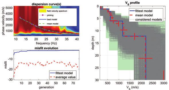
DOI: 10.7343/as-2019-409

Quaternary, it generally acts as an aquiclude/aquitard; iv)                      2.5 m, aligned along a straight line to simulate two 30m-long
detrital deposit complex, intermediate relative permeability                     seismic lines. The energy source was a falling-down mass
grade, Quaternary, it may host subordinate aquifers.                             (>20 kg) at a minimum offset of 5 m from the first receiver. The
                                                                                 seismograms were registered by a 1s length and a sampling
Methods                                                                          interval of 1ms. The commercial software winMASW by
   Hydrogeological surveys, which will be performed for                          Eliosoft (www.winmasw.com) was used for analyzing the
about two hydrological years on monthly or bimonthly                             surface wave dispersion and retrieving vertical shear-waves
steps starting from July 2018, consisted in the measurement                      profiles.
of in situ chemical-physical parameters of the lake’s waters
(temperature, T; specific electrical conductivity, EC; pH) and                   Results and discussion
spring flow rate. The data collected from July to November                         The physical-chemical characteristics of the waters (T=12-
2018 refer to the development of a summer-autumn low water                       13°C; pH=8-9) are consistent with those of stagnant and slightly
condition. From December to May 2018, the Lake area could                        oxygenated waters. The low values of EC (60-125 µS/cm) of
not be reached since it was covered by snow.                                     the lake’s waters with respect to those collected from the
   The geographical coordinate of lake edges were surveyed                       carbonate aquifer springs of the Sibillini Mts. area (180-
for the assessment of the variations of the lake level with time.                640 µS/cm; e.g. Boni et al. 1986) is in accordance with the
   A drone photogrammetric survey was performed, using                           prevailing provenance of the lake’s recharge by snow melting
a Phantom 4 drone. The survey, carried out according to                          and precipitation. The Fonte del Lago temporary spring
the standards known in the literature (Niedzielski 2019),                        stopped to yield water in July 2018 and then, only a single
involved an area of over 4 hectares with a flight height of 70                   measure of the hydrochemical features of its emitted water
m. Image processing allowed to obtain a high resolution 3D                       was collected (EC = 133 µS/cm; T = 4 °C; pH = 8.3).
model, textured in real colors.                                                    The drone photogrammetric survey allowed the
   Aim of the drone survey was also to allow the reconstruction                  preliminary reconstruction of the bathymetry of the basin for
of the bathymetry of the basin for water volume calculation                      water volume calculation and a first detailed reconstruction
and a first detailed reconstruction of the morphological                         of the morphological setting of the lake area. In the Pilato
setting of the lake area. Moreover, it was possible to verify the                Lake area, there are no morphological evidences of tectonic
absence of deformations induced by seismicity on the ground,                     ruptures induced by the 2016-2017 seismic sequence
which on the contrary are evident along the external western                     potentially responsible for the complete drying of the lake
slope of Monte Vettore (Testa et al. 2019).                                      during summer 2017. Then, the drying out was likely due to
   The local meteoclimatic features were delineated by the                       meteoclimatic reasons and/or to not yet verified variations in
analysis of available datasets from Regione Marche (2002-2018).                  the permeability characteristics of the surficial deposits and/or
Selected meteo-climatic stations are located at Montemonaco,                     bedrock affecting the infiltration towards the subsoil, caused
Monte Prata and Monte Bove Sud and provided precipitation                        by the severe seismic shaking.
(snow, where available) and temperature data over a period                         The most representative meteorological station for climatic
of about twenty years (where possible). Long-term averages                       conditions of Pilato Lake is at Monte Prata, due to similar
and average values of individual years were evaluated and the                    exposure and altitude. The analysis of the data showed that
resulting deviations were compared. The statistical analysis                     the estimated annual average of temperature is 6°C, rainfall is
of time series allowed the assessment of long-term trends                        900 mm/y and snowfall is 1500 mm/y. The available snowfall
and cycles, in addition to the seasonal component. Water                         amounts are not yet officially validated and then they need
loss through evaporation from the lake surface will be also                      further verification. A general time tendency to temperature
estimated (e.g. Visentini 1937; Dragoni and Valigi 1994).                        increase emerged, along with a substantial constancy of liquid
   Geophysical investigations consisting in two active                           precipitation and a reduction in snowfall, which is above all
seismic surveys aimed at subsoil characterization in terms                       concentrated in April. These trends are confirmed by the non-
of shear-waves velocity (Vs), a parameter directly related to                    parametric Mann-Kendall test (Kendall et al. 1983; Sneyers
the stiffness of the materials, were conducted. Accordingly,                     1990). The persistence of the snowpack in the spring season
a preliminary estimate of thickness of loose debris deposits                     ensures a constant recharge to the lake’s waters and in turn
over the bedrock was realized. The seismic surveys were                          assures, despite of the relatively slow drainage through the
performed in the Pilato Lake area in November 2018. Two                          deposits within the lake bed, a not complete drying before
lines (SW1 and SW2; Fig.1) were investigated by using                            the following winter season. This circumstance is therefore
the surface-waves method (e.g. Dal Moro 2015) aiming to                          crucial to avoid the periodic complete disappearance of the
possibly infer a constrain to the maximum thickness of debris                    lake. Probably, the complete drying of Pilato Lake in the year
deposits (detrital and glacial sediments on top of calcareous                    2017 was mainly due to air temperatures higher than the
bedrock) by differentiating layers in terms of shear-waves                       long-term annual average, which led to early melting of the
velocity values. In both sites a multichannel simulation (e.g.                   snowpack, and subordinately to particularly reduced Spring
Lin and Ashlok 2016) was performed by using a single three-                      rainfall (Fig. 2).
component receiver and ten shot-positions, equally spaced of                       According to the results obtained from the multichannel

Acque Sotterranee - Italian Journal of Groundwater (2019) - AS31- 409: 23 - 28                                                               25
DOI: 10.7343/as-2019-409

                                                                                          basin is not feasible at present, since a validated bathymetry
                                                                                          of the lake area is not still available.

                                                                                          Conclusions
                                                                                            The research program is still in progress and to date we
                                                                                          can propose only preliminary remarks. The hydrogeological
                                                                                          surveys demonstrate the absence of geomorphological evidence
                                                                                          of earthquake fractures: therefore, the complete drying of the
                                                                                          lake occurred in summer 2017 was probably mainly due to the
                                                                                          annual temperature, 0.9°C higher than the average (leading
                                                                                          to early snowpack melting), and subordinately to particularly
                                                                                          reduced Spring rainfall.
                                                                                            The low values of EC of the lake’s waters are in accordance
Fig. 2 - Plots of April cumulative monthly snow (left axis) and of deviation of average
                                                                                          with the prevailing provenance of the lake’s recharge by snow
annual temperature (right axis) with time. A clear negative trend of cumulative monthly   melting and direct rainfall.
snow with time, also confirmed by the Mann-Kendall test, is evident. In the year, 2017      The drone aero-photogrammetric survey allowed a
the average annual temperature was the highest among the average values calculated        preliminary reconstruction of the lake basin bathymetry
during 2002-2018.
                                                                                          that will allow, in turn, the calculation of the water volumes
Fig. 2 - Diagrammi della neve cumulata nei mesi di aprile (asse di sinistra) e
della deviazione delle temperature dalla media annua (asse di destra) rispetto            within the lake in the various observed periods.
al tempo. È evidente il trend negativo, confermato anche dal test di Mann-                  As concerns the first geophysical surveys in the Pilato Lake
Kendall, della neve cumulata mensilmente nel tempo. Nell’anno 2017 la                     area, according to the geophysical models, the thickness of
temperatura media annua è stata la più elevata tra i valori medi calcolati nel            debris varies from few meters to 14 m.
periodo 2002-2018.
                                                                                            The lake level from its maximum flooded elevation in May-
analysis of surface waves (see Figs. 3 and 4) shear-waves                                 June 2018 (completion of snow melting; about 1960 m a.s.l.)
velocities varied from 310-320 m/s close to the surface to                                dropped rather rapidly to the elevation of the Fonte del Lago
more than 1500 m/s in depth. Due to the lack of a-priori                                  spring (about 1955 m a.s.l.) which acts as an overflow. Water
geological information, the Vs profiles are poorly constrained                            levels declined more slowly due to evaporation and infiltration
especially for the deepest layers; nonetheless, the depth of the                          through the glacial deposits in the subsoil (also evidenced by
rocky bedrock was inferred by considering Vs values higher                                the performed geophysical surveys) and furthermore reached
than 1000 m/s, thus estimating the maximum thickness of                                   down the minimum levels in November (about 1950 m a.s.l.).
debris equal to about 14 m and 6 m along SW1 and SW2                                      Finally, in particularly arid years, the lake may dry out.
sites, respectively.                                                                        Further investigation in the study area will include: i)
   The surveys of the lake margins collected during July-                                 hydrogeological surveys during about two hydrological years
November 2018 (Fig. 1) and evidences from pictures taken by                               on monthly/bimonthly steps, ii) in depth analyses of long-
local people show that the lake water levels had a relatively                             term meteoclimatic data and estimate of evaporation from the
rapid decrease from the maximum elevation of about 1960                                   lake surface, iii) geophysical investigations, including seismic
m a.s.l. in May-June, after the complete melting of snows, to                             and GPR surveys, iv) a more detailed drone photogrammetric
the elevation of about 1955 m a.s.l. in July. This is due to the                          survey.
presence of the Fonte del Lago spring, acting as an overflow
for waters. Then water levels went down more slowly due to
evaporation and a still unknown infiltration rate through
the bed terrains of the two pond areas (at this moment the
lake went to a separation), reaching the minimum values
of about 1950 m a.s.l. of elevation surveyed in November.
In particularly dry years, as during summer 2017, the two
separated ponds (Fig. 5) may dry out (Fig. 6).
   The whole of the former results allowed a preliminary
reconstruction of the hydrogeological conceptual model for
the Pilato Lake area (Fig. 6). The water overflow through the
Fonte del Lago spring, the evaporation from the lake surface
and the drainage process through the scarce permeability
glacial deposits (also evidenced by the performed geophysical
surveys) towards the Basal Calcareous Aquifer, hosted at lower
elevations within the calcareous deposits, are responsible
for the progressive lowering of the lake level. A reliable
calculation of the hydrogeological budget of the Pilato Lake

26                                                                                        Acque Sotterranee - Italian Journal of Groundwater (2019) - AS31- 409: 23 - 28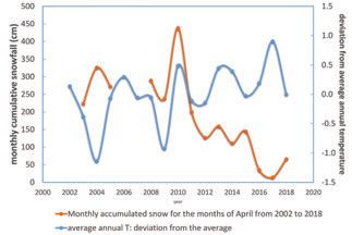
DOI: 10.7343/as-2019-409

Fig. 3 - Results of the seismic survey at the SW1 site, located between the two already separated small ponds.
Fig. 3 -Risultati dell’indagine sismica nel sito SW1, ubicato tra i due piccoli bacini ormai separati.

Fig. 4 - Results of the seismic survey at the SW2 site, located at north with respect to the two already separated small ponds.
Fig. 4 -Risultati dell’indagine sismica nel sito SW2, ubicato a nord dei due piccoli bacini ormai separati.

                                                                                             Fig. 5 - Aero-photogrammetric survey taken by drone at the beginning of June 2017
                                                                                             in the Pilato Lake area. View from south to north. The picture field is about 100 m in
                                                                                             width x 400 m in perspective depth.
                                                                                             Fig. 5 - Rilievo aerofotogrammetrico da drone nell’inizio del giugno 2017
                                                                                             nell’area del Lago di Pilato. Vista da sud a nord. Il campo immagine copre circa
                                                                                             100 m in larghezza e 400 m in profondità.

Acque Sotterranee - Italian Journal of Groundwater (2019) - AS31- 409: 23 - 28                                                                                              27
DOI: 10.7343/as-2019-409
Fig. 6 - 2D sketch of the hydrogeological asset of the Pilato Lake area (horizontal and vertical scales are approximately the same). Thickness of detrital and glacial deposits (about
15 m in total) and hydro/piezometric level variations (about 20 m in total from 1. to 4. position) are exaggerated for a clearer readability. Sketch location is shown in Fig. 1.
Fig. 6 - Schema idrogeologico 2D dell’area del Lago di Pilato (la scala orizzontale è circa la stessa di quella verticale). Gli spessori dei depositi detritici e glaciali
(circa 15 m in totale) e le variazioni dei livelli idro/piezometrici (circa 20 m in totale dalla posizione 1. alla 4.) sono stati esagerati per permetterne una migliore
visibilità. La traccia dello schema è riportata in Fig. 1.
REFERENCES
Amoruso A, Crescentini L, Martino S, Petitta M, Tallini M (2014) Cor- Niedzielski T (ed.) (2019) Application of Unmanned Aerial Vehicles in
relation between groundwater flow and deformation in the frac- Geosciences. Birkhauser Base, Springer, 250 pp
tured carbonate Gran Sasso aquifer (INFN underground labora- Petitta M, Primavera P, Tuccimei P, Aravena R (2011) Interaction be-
tories Central Italy). Water Resource Research 50(6):4858-4876. tween deep and shallow groundwater systems in areas affected by
(HTTPS://DOI.ORG/10.1002/2013WR014491) quaternary tectonics (central Italy): a geochemical and isotope ap-
Boni C, Baldoni T, Banzato F, Cascone D, Petitta M (2010) Hydrogeo- proach. Environmental Earth Science 63:11–30
logical study for identification, characterization and management of Regione Marche (2002-2018) Servizio di Protezione Civile - Sistema
groundwater resources in the Sibillini Mountains National Park (cen- Informativo Regionale Meteo-Idro-Pluviometrico “Marche Region -
tral Italy). Italian Journal of Engineering Geology and Environment Civil Protection Service - Meteo-Hydro-Pluviometric Regional Information
2:21-39. (HTTPS://DOI.ORG/10.4408/IJEGE.2010-02.O-02) System”. https://www.regione.marche.it/Regione-Utile/Protezione-
Boni C, Bono P, Capelli G (1986) Schema idrogeologico dell’Italia Cen- Civile/Progetti-e-Pubblicazioni/Meteo. Cited May 2019
trale “Hydrogeological Sketch Map of Central Italy”. Memorie Società Ruffo S, Vesentini G (1957) Una nuova specie di Fillopode Anostraco
Geologica d’Italia 35:991-1012 dei Monti Sibillini (Chirocephalus marchesonii n. sp.) “A new species
Dal Moro G (2015) Surface Wave Analysis for Near Surface Applications. of Anostracus Phillopod of the Sibillini Mts (Chirocephalus marchesonii
Elsevier. https://doi.org/10.1016/B978-0-12-800770-9.18001-X n. sp.)”. Memorie Museo Civico di Storia Naturale, Verona, 6:1-8
Dragoni W, Valigi D (1994) Contributo alla stima dell’evaporazione Sneyers R (1990) On the statistical analysis of series of observations.
dalle superfici liquide nell’Italia Centrale “Contribution to the estimate Technical Note N.143, World Meteorological Organization, Ge-
of the evaporation from the bodies of water of the Central Italy”. Geologica neva, Switzerland
Romana 30:151-158 Testa A, Boncio P, Di Donato M, Mataloni G, Brozzetti F, Cirillo D
Fiorillo F, Petitta M, Preziosi E, Rusi S, Esposito L, Tallini M (2015) (2019) Mapping the geology of the 2016 Central Italy earthquake
Long-term trend and fluctuations of karst spring discharge in a fault (Mt. Vettore–Mt. Bove fault, Sibillini Mts.): geological details
Mediterranean area (central-southern Italy). Environmental Earth on the Cupi-Ussita and Mt. Bove-M.Porche segments and overall
Sciences 74(1):153–172. https://doi.org/10.1007/s12665-014-3946-6. pattern of coseismic surface faulting. Geological Field Trips and
Kendall M, Stuart A, Ord JK (1983) The advanced theory of statis- Maps 11. ISSN: 2038-4947 (http://gftm.socgeol.it/)
tics. Volume 3, Charles Griffin e Company Limited, London e High Visentini M (1937) L’evaporazione dagli specchi liquidi “The evaporation
Wycombe from bodies of water”. Memorie e Studi Idrografici. Servizio Idrografi-
Lin S, Ashlock JC (2016) Surface-wave testing of soil sites using co, Publication N.2. Istituto Poligrafico dello Stato, Rome
multichannel simulation with one-receiver. Soil Dynamics and
Earthquake Engineering 87:82-92. https://doi.org/10.1016/j.soil-
dyn.2016.04.013
28 Acque Sotterranee - Italian Journal of Groundwater (2019) - AS31- 409: 23 - 28Puoi anche leggere