SPATIOTEMPORAL DATA MANAGEMENT OF RECURRENT DEBRIS FLOW EVENTS USING OBJECT-ORIENTED DATA MODELLING
←
→
Trascrizione del contenuto della pagina
Se il tuo browser non visualizza correttamente la pagina, ti preghiamo di leggere il contenuto della pagina quaggiù
DOI: 10.4408/IJEGE.2021-01.S-22

SPATIOTEMPORAL DATA MANAGEMENT OF RECURRENT DEBRIS FLOW EVENTS
            USING OBJECT-ORIENTED DATA MODELLING

                                            Mario VALIANTE(*,**), Domenico GUIDA(*,**),
                                          Marta DELLA SETA(***) & Francesca BOZZANO(***)

                                               (*)
                                                   University of Salerno, Department of Civil Engineering - Fisciano, Italy
                 (**)
                        University of Salerno, C.U.G.RI. - interUniversity Centre for the prediction and prevention of Major Risks - Salerno, Italy
                               (***)
                                     Sapienza University of Rome, Earth Science Department - Piazzale Aldo Moro 5 - 00185 Roma, Italy
                                                            Corresponding author: mario.valiante@gmail.com

Extended abstract
     Il presente lavoro è focalizzato sulla gestione “object-oriented” dei dati spaziotemporali relativi ad eventi ricorrenti di colate
detritiche che si sviluppano lungo tutti i canaloni che incidono il fronte settentrionale del monte Bulgheria (Geoparco del Cilento,
Italia meridionale). In particolare, l’area di studio è costituita da due canaloni principali: il vallone del Moio e Valle della Noce
che, in tempi recenti (2015-2018), sono stati interessati da fenomeni di flusso detritico a diversa concentrazione, analoghi a quelli
di maggiore magnitudo registrati dalle cronache storiche.
     Tali fenomeni costituiscono un fattore di rischio sia per i centri abitati del comune di Celle di Bulgheria, nonché per le principali
vie di comunicazione locali. L’assetto strutturale principale del fronte montagnoso è caratterizzato dalla sovrapposizione tettonica
tipo piega-faglia delle unità carbonatiche meso-cenozoiche, ridenominate “sub-unità tettonica Bulgheria in Graziano et alii (2016)
sia sulle formazioni silico-clastiche mioceniche della medesima sub-unità che su quelle bacinali oligo-mioceniche delle Unità
Interne (Cammarosano et alii, 2004). L’attuale assetto morfologico del versante montuoso è fortemente controllato dall’assetto
strutturale sopra descritto, con pareti di interfluvio sub-verticali e profondi canaloni ad alta pendenza. La zona sommitale è
caratterizzata da una singolare conformazione a crinali longitudinali sdoppiati, tra i quali sono presenti vallecole colmate da
spessori anche decametrici di depositi eluvio-colluviali con matrice piroclastica cineritica alterata, alla cui terminazione inferiore si
innestano le testate dei canaloni sopra citati, a forte tendenza retrogressiva (Guida et alii, 1989). È proprio da queste vallecole che
derivano le frazioni fini dei flussi detritici che, amplificandosi di materiale grossolano lungo i canaloni, raggiungono il piedimonte
in forma di ricorrenti colate detritiche e flussi iperconcentrati.
     La successione degli eventi è stata ricostruita tramite la consultazione di cronache storiche ed inventari preesistenti, l’analisi di
immagini ottiche, sia aeree che satellitari, ed attività di rilevamento diretto a seguito dell’occorrenza dei principali eventi. L’evento
di flusso più antico registrato risale al 1878. Esso è stato caratterizzato dall’intensità maggiore ad oggi registrata con danni agli
insediamenti ed alle persone. Ulteriori eventi si sono succeduti nell’ultimo secolo, in particolare crolli permanenti dalle pareti più
alte e dai fianchi vallivi che hanno progressivamente contribuito al riempimento dei canaloni, successivamente svuotati, in un ciclo
filling-discharging-refilling (Guida, 2003). Due episodi di flusso ricostruiti da rapporti di evento si sono verificati tra gli anni ‘80
e ’90, fino ad arrivare all’ultimo decennio, durante il quale si è riscontrata la frequenza più elevata di colate detritiche, a magnitudo
crescente.
     L’inventario è stato riformulato seguendo lo schema logico e procedurale orientato agli oggetti, denominato LOOM (Landslide
Object-Oriented Model, Valiante et alii, 2021), in modo da consentire una strutturazione informatica spaziotemporale dei dati e
di gestione “ad eventi” delle informazioni utili alle valutazioni di pericolosità e rischio da questi fenomeni ad alta intensità. Nel
caso considerato, a partire dalle colate detritiche inventariate, un unico complesso di colate di terra granulare è stato generato;
ciò dimostra come il concetto di “complesso di frane” racchiuda sia una connotazione spaziale, di sovrapposizione/sostituzione
di una stessa tipologia di fenomeno, sia una connotazione temporale di ricorrenza e ripetitività dello stesso nel medesimo ambito
morfologico. Come per i flussi detritici, lo stesso vale per i crolli avvenuti lungo le pareti dei canaloni. L’ordinamento temporale
dei diversi tipi di fenomeno, unitamente alla loro sovrapposizione spaziale, conferisce, invece, al concetto di “sistema di frane” il
ruolo di scenario dominante dell’evoluzione gravitativa di un versante/fronte montuoso.
      Nel caso di studio esaminato emerge la ciclicità nell’attività gravitativa lungo i canali. Il sistema di gestione dei dati illustrato
consente di superare sia il tradizionale concetto di “inventario”, che quello di “attività”, suggerendo la introduzione di un nuovo
concetto di gestione del dato e delle informazioni inerenti all’intera storia gravitativa ricostruita in termini contemporaneamente
diatopici e diacronici e proponendo il neologismo “eventario”, quale base di discussione nell’ambito delle discipline di settore.

Italian Journal of Engineering Geology and Environment, 1 (2021)             © Sapienza Università Editrice                                 www.ijege.uniroma1.it   239
M. Valiante, d. guida, M. della seta & F. bozzano

      Abstract                                                                       of the most dangerous landslide types, posing major threats to
           This work is focused on the study of recurrent debris flow                human lives and their related settlements, infrastructures, and
      events on the north-facing mountain slope of the Bulgheria massif              activities (Bovis & Jacob, 1999; Perov et alii, 2017; Naidu et
      (Cilento Unesco Geopark, southern Italy). These phenomena                      alii, 2018; Cascini et alii, 2019; Kean et alii, 2019). Producing a
      pose a threat for at least two villages and infrastructures on the             data structure and mapping capable of storing temporal occurrence
      lower slope. The main morpho-structure of the mountain slope is                and recurrence of debris flows and their spatial relations with other
      strongly controlled by the tectonic overlapping in form of multiple            landslide types could be a useful tool to better improve landslide
      thrust-folding of the Meso-Cenozoic limestone related to the inner             hazard assessment and mitigation at different scales.
      margin of the Apennine Carbonate Platform over lower-middle                         Recently, a landslide object-oriented method (LOOM) has
      Miocene marly-clay flysch and previously overthrusted basinal                  been proposed by the authors (Valiante et alii, 2021) in order to
      units ranging from upper Oligocene to lower Miocene. Therefore,                tentatively overcome a few limitations in the traditional landslide
      the mountain slope is sculpted by erosional deep incided ravines               data model procedures. Please refer to this work for a more in-depth
      and sub-structural interfluve cliffed slopes passing downslope                 examination of the comparative analysis of existing methodologies.
      to depositional piedmont by evident and abrupt knick-point.                         In fact, the aim of this paper is to describe how we can manage
      Channels along the slope are periodically filled both through rock             dataset from recorded or surveyed recurrent landsliding events
      fall deposits occurring on channel’s flanks and by soil creep and              occurred along two steep ravines on the northern slope and piedmont
      sheet wash phenomena at channel’s heads, which supply new                      of the Bulgheria Massif, uphill of the Celle di Bulgheria village
      material for future flows. Such relationship between infilling rock            (Campania region, Italy): the Moio and Valle Noce channels (Fig.
      fall phenomena and debris flows represents an interesting case                 1). Along these channels several landsliding phenomena occurred
      study of interaction among different and concurrent landslide                  in the last centuries, such as concurrent and delayed rock falls,
      types providing an optimal example of space-time evolving                      debris flows, and shallow soil slips at channel heads, as reported in
      landslide system. Landslide classes have been stored and mapped                an un-published report by one of the authors (Guida, 2019), who
      using a previously proposed object-oriented and event-based                    was in charge to propose a design for risk mitigation. Historically
      model and producing in this way a multi-temporal database.                     recorded and observed phenomena have been inventoried using
      Landslide objects have been grouped into landslide subclasses                  a hierarchical object-oriented approach, taking into account
      using the latest landslide classification available. In the next               geological, geomorphic and climatic constraints, as illustrated in
      step, a hierarchical classification has been applied, introducing              the following sections.
      two levels of aggregation and one level of decomposition.
      Landslide complexes group landslide objects of the same class
      sharing spatial connection, defining rock fall complex objects
      and granular soil wet flow complex objects. Landslide systems
      group all the interacting landslides, regardless of their type.
      Landslide components describe the various portions of a single
      landslide object. Every stored object has its temporal attributes
      distinguishing between time points (events) and time intervals
      (time frames). The integration of complex spatial relations
      through topological analysis and temporal characterization of data
      allows to build a flexible database structure adaptable to several
      specific needs and different outputs, such as basic landslide
      maps or event maps, multi-temporal and frequency analyses, or                  Fig. 1 - Location and geological settings of the study area (modified
      the study of the interactions among different types of landslide                        from ISPRA, 2014)
      hazards. In this framework, a neologism could be introduced in
      landslide studies, as landslide eventory mapping, as a challenge               GEOLOGICAL AND                    GEOMORPHOLOGICAL
      for future applications.                                                       SETTINGS
                                                                                          The Bulgheria carbonatic massif is built up by a platform
      Keywords: landslide object-oriented model, landslide complex,                  margin stratigraphic succession ranging from upper Trias to
      landslide system, Bulgheria mountain, Cilento Geopark, Southern Italy          Miocene called Mt. Bulgheria tectonic sub-unit (D’Argenio et
                                                                                     alii, 1973; Graziano et alii, 2016). Along the northern front of
      Introduction                                                                   the Bulgheria Massif the younger formations of the tectonic unit
          In the field of geohazards, debris flow phenomena are one                  crop out, and they are mainly composed of stratified calcarenites

240   Italian Journal of Engineering Geology and Environment, 1 (2021)   © Sapienza Università Editrice                               www.ijege.uniroma1.it
SPATIOTEMPORAL DATA MANAGEMENT OF RECURRENT DEBRIS FLOW EVENTS USING OBJECT-ORIENTED DATA MODELLING
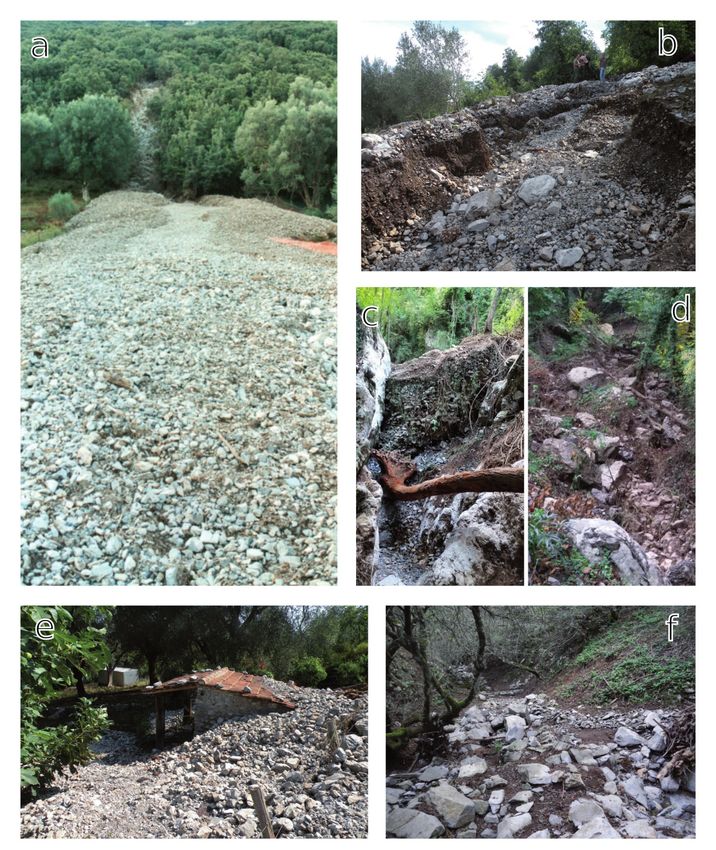
and calclutites, oolitic calcarenites and bioclastic calcrudites. The evolved in debris flood -like phenomena exploiting existing roads
youngest formation of Mt. Bulgheria tectonic sub-unit cropping as preferential flow paths (Fig. 2b, c). The next event involving
out in the study area is a marly-calcareous and clayey flysch. the Moio channel occurred on November 11, 2017 causing also
Previous formations tectonically overlap terrigenous formations damages to agricultural activities (Fig. 2d). The latest recorded
belonging to the so-called Internal Units (Bonardi et alii, 1988; event occurred on August 20, 2018. In this case, floods originated
Cammarosano et alii, 2004). From a structural perspective, the from the debris fan reached the Celle di Bulgheria village flowing
Bulgheria Massif is made up by an asymmetrical overturned along local roads (Fig. 2e, f).
fold and a complex overlapping structure which includes reverse Survey activities performed after the latest events (2001, 2015,
faults and fault propagation folds, overlapping the carbonatic 2017, 2018) highlighted heterometric limestone boulders deposits
succession over the terrigenous flysch deposits (Guida et alii, along the channels produced by the recurrent accumulation of rock
1989). At the foot of the entire mountain front, extensive coarse fall debris occurring on channel’s flanks (Fig. 2d, f). Such rock falls
deposits can be found as partially cemented calcareous breccias have been inventoried by field surveys and through the analysis of
or loose debris (Fig. 1). optical images, both aerial and satellite.
The northern hillslope of the Bulgheria Massif has experienced an Within channel heads, shallow soil creep phenomena were
initial evolution following a slope replacement model, exploiting observed, which, combined with diffusive erosion, concurred to the
structural features such as bedding and fault planes (Guida et accumulation of loose material at the hollow’s bottoms.
alii, 1989). Such evolution produced the actual morphology
characterized by steep rocky cliffs on the upper section of the relief, BUILDING OF THE LANDSLIDE DATABASE
and a less sloping lower section produced by the accumulation of The inventory database has been built using the LOOM data
detritical materials. Along the main ridge, longitudinal valleys can structure (Valiante et alii, 2021). Such data structure is composed
be found as hollows, often filled with pyroclastic and residual soils. of hierarchical levels organized following an object-oriented
All of the mountain front is nowadays carved by straight channels paradigm (Hegenhofer & Frank, 1992) and the focal level of this
having different incision rate, producing a series of debris fans at hierarchy contains landslide objects. Focal objects result from the
the footslope, such as the Moio and Valle Noce channels, on which aggregation of landslide components such as detachment areas,
this study is focused. channels, debris, etc., so that every landslide object is represented
by a single aerial geometric feature (polygons). At the focal level,
EVENTS HISTORY the landslide class is specialized into 21 sub-classes based on
The events history has been reconstructed through the analysis the main type of movement (Hungr et alii, 2014). Referring to
of pre-existing available inventories (ex-Left Sele River Basin the landslide types analysed in this work, movements classified
Authority, now Southern Apennines Hydrographic District, 2012 primarily as debris flow are instances of the granular soil wet flow
- PSAI), satellite and aerial photointerpretation and original data class, while rock falls are instances of the rock fall class.
collected during field surveys. Starting from the focal level of the hierarchy, two levels of
The oldest reported event dates back to September 25, 1878 as aggregation store landslide complex objects and landslide system
it is stated in the PSAI inventory. This is the event with the highest objects. The landslide complex class derives from the generalization
volume of displaced material, and it was originally inventoried of 21 landslide complex sub-classes which are built from the
using archive material from the involved municipality. This event aggregation of the 21 landslide sub-classes. The aggregation
is well known in the local history and related documents as “Acqua procedure to build a landslide complex object is triggered only if
della Montagna” (Lit. “Mountain’s water”), luckily no casualties two or more landslide objects of the same type satisfy the relation
were registered. of Functional Interaction defined in the LOOM data structure, so
Another smaller event is reported on the October 7 of the that a landslide complex can be defined as a set of landslides of
previous year, but unfortunately, the available information is not the same type spatially overlapping. A further level of aggregation
enough to properly insert a record in the inventory. Other flow takes as input both landslide complex objects and landslide objects
events have been registered in the second half of 1900, and the previously excluded from the aggregation, performing again the
most recent events occurred in 2001, 2015, 2017 and 2018. Flows Functional Interaction check. In this level landslide system objects
occurred on September 5, 2001 can be related to an extreme are generated, and they can be defined as a set of landslides spatially
rainfall event following the dry season, which triggered several connected, regardless of their type.
flows along the entire mountain front including also the channels Landslide objects are described also by temporal attributes in
object of this study (Fig. 2a). On September 24, 2015 several debris order to store and retrieve the temporal succession of the events.
flows were triggered again by a heavy rainfall, damaging public The temporal information is managed using temporal intervals
and private properties. During this event, most of the debris flows (temporal frames) for temporally undetermined landslides, and
Italian Journal of Engineering Geology and Environment, 1 (2021) © Sapienza Università Editrice www.ijege.uniroma1.it 241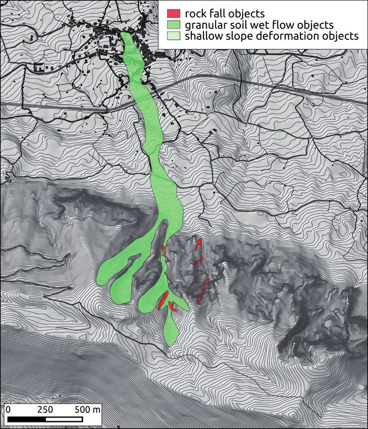
M. Valiante, d. guida, M. della seta & F. bozzano

      Fig. 2 - a) 2001 debris flow deposit; b) 2015 debris flow erosional features; c) 2015, filling deposit within the main channel; d) 2017, boulders along the
               channel; e) 2018, half-buried shelter; f) 2018, boulders along the channel (Photos by D. Guida)

242   Italian Journal of Engineering Geology and Environment, 1 (2021)      © Sapienza Università Editrice                                 www.ijege.uniroma1.it
SPATIOTEMPORAL DATA MANAGEMENT OF RECURRENT DEBRIS FLOW EVENTS USING OBJECT-ORIENTED DATA MODELLING

temporal points (events) for landslides having an exact date of
occurrence. Time frame’s boundaries are derived both from known
events and from time references of the exploited materials, such
as images and other inventories. For the Moio and Valle Noce
channels case study, the following events-time frames have been
implemented:
 1.         Event - September 25, 1878
 2.         Time frame - Late 1878 - 1943
 3.         Time frame - 1944 - 1988
 4.         Time frame - 1989 - 1994
 5.         Time frame - 1995 - 2000
 6.         Time frame - January 1, 2001 - September 4, 2001
 7.         Event - September 5, 2001
 8.         Time frame - Late 2001 - 2006
 9.         Time frame - 2007 - 2012
 10.        Time frame - 2013 - September 23, 2015
 11.        Event - September 24, 2015
 12.        Time frame - Late 2015 - November 10, 2017
 13.        Event - November 11, 2017
 14.        Time frame - Late 2017 - August 19, 2018
 15.        Event - August 20, 2018
 16.        Time frame - after August 21, 2018
     After the first described debris flow event occurred in the 1878,
a few rock falls have been noticed in the images referred to time              Fig. 3 - Event 1 - September 25, 1878
frames 2 and 3, and a debris flow has been inventoried within
time frame3. During time frames 4 and 5 other falls have been
inventoried and another flow has been reported which should have
been occurred in 1996 in accordance with technical documentation
from the local municipality. Within the successive time frames,
other rock falls have been identified, noticeable in 2010 and 2015,
before event 11. Minor falls have been also reported in the latest
time frames. Soil creep phenomena have been identified after field
surveys performed following events 11 and 15 (Fig. 3 to Fig. 11).

DISCUSSIONS
    The LOOM data structure allows the management of
complex spatial arrangements of landslides. Spatial overlapping
between landslide objects has been handled through the
evaluation of the topological relations between such features,
categorizing those relations satisfying a Functional Interaction
threshold and those which does not. This procedure leads
to the simplification of the initial complex arrangement of
objects through the hierarchical aggregation. From the first
cycle of aggregation, landslide complex objects are generated.
Regarding granular soil wet flow objects (debris flows), a single
granular soil wet flow complex object has been generated (Fig.
12). In this case, the spatiotemporal connotation of a landslide
complex object is exemplified: from a spatial point of view,
within this landslide complex, phenomena occurring in two
different channels are aggregated because of the overlapping                   Fig. 4 - Time frames 2,3 - from late 1878 to 1988

Italian Journal of Engineering Geology and Environment, 1 (2021)   © Sapienza Università Editrice                                  www.ijege.uniroma1.it   243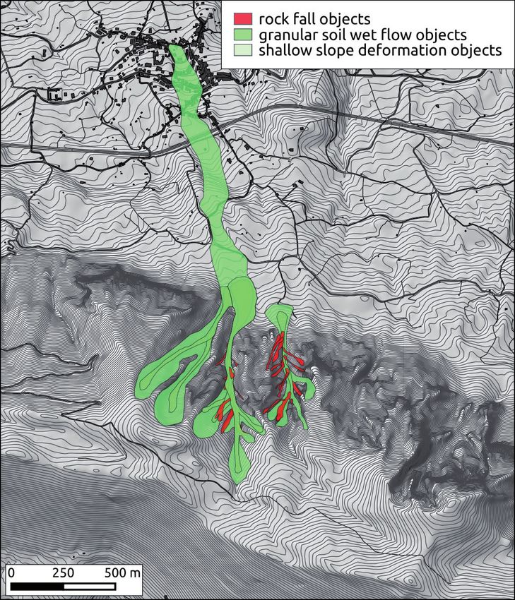
M. Valiante, d. guida, M. della seta & F. bozzano

      Fig. 5 - Time frame 4 - 1989 - 1994                                             Fig. 7 - Time frame 6 - 2001 and event 7 - September 5, 2001

      Fig. 6 - Time frame 5 - 1995 - 2000                                            Fig. 8 - time frames 8, 9 and 10 - from late 2001 to 2015

244   Italian Journal of Engineering Geology and Environment, 1 (2021)   © Sapienza Università Editrice                                  www.ijege.uniroma1.it
SPATIOTEMPORAL DATA MANAGEMENT OF RECURRENT DEBRIS FLOW EVENTS USING OBJECT-ORIENTED DATA MODELLING

Fig. 9 - Event 11 - September 24, 2015                                         Fig. 11 - Event 15 - August 21, 2018

                                                                               in the accumulation area, which in turn means that specific
                                                                               accumulation area is the result of those phenomena happening
                                                                               in two different basins intended as morphological units; from
                                                                               a temporal perspective instead, we have the aggregation of
                                                                               several events occurred in the same channel highlighting the
                                                                               repetitiveness of the phenomenon. These considerations hold
                                                                               true also for the various rock fall complex objects aggregated
                                                                               at this step, in fact, the presence of several rock fall complexes
                                                                               shows the periodical discharge of loose debris from channel’s
                                                                               flanks to their bottom. At the top of the relief, a shallow slope
                                                                               deformation complex is produced from the enlargement of
                                                                               the soil creep affected area at the Moio channel’s head over
                                                                               the years. The second aggregation step produced landslide
                                                                               system objects. In this case study, all of the landslide objects
                                                                               inventoried produced the aggregation of a single landslide
                                                                               system object (Fig. 13). Data-wise, a landslide system has
                                                                               been defined has a spatial overlap between different landslide
                                                                               typologies and that is indeed the basic concept which allows
                                                                               the automatic aggregation procedure. Nonetheless, in the
                                                                               spatiotemporal framework, the concept of landslide system
                                                                               also retains the temporal interaction between different kind
                                                                               of phenomena. In this perspective, the event succession
                                                                               encapsulated in the landslide system definition can be thought
                                                                               as a conceptual model of the gravitational evolution of the
Fig. 10 - Event 13 - November 11, 2017                                         investigated geomorphological system. In our case study, we

Italian Journal of Engineering Geology and Environment, 1 (2021)   © Sapienza Università Editrice                            www.ijege.uniroma1.it   245
M. Valiante, d. guida, M. della seta & F. bozzano

      Fig. 12 - Landslide complex objects                                            Fig. 13 - Landslide system objects

      have slow shallow deformations accumulating loose material                     localized events, due to local orographic seeder-feeder effects
      at the channel’s head and rock falls supplying boulders                        (ROE, 2005, Cuomo et alii, 2011, Furcolo & Pelosi, 2018),
      and debris in the middle section of such channels. In turn,                    as it was for the 2015 event (Fig. 14, Fig. 15).
      periodically these channels are emptied through impulsive
      phenomena such as the observed debris flows.                                   CONCLUSIONS
          Temporal attributes technically allow the vertical sorting                     In this study, a hierarchical object-oriented data model for
      of the overlapping features for the visual representation.                     landslides has been applied for the study of recurring debris
      Moreover, the temporal sorting of the inventoried objects                      flow events. Such model aims at preserving spatiotemporal
      showed a discontinuous event distribution over the                             relations between landslide objects for an optimal inventorying
      investigated time period. Besides the 1878 event, we have a                    and representation of complex superimpositions of landslide
      few events between 1980 and 2001 and a cluster of events                       events.
      in the 2015-2018 time period. Such intermittent activity                           The application has been carried out along two channels
      could be related to the evolution model discussed before for                   on the northern front of the Bulgheria Massif (southern Italy).
      the landslide system, which could be described as a cyclic                     The hierarchical classification allowed to simplify all of the
      recurrence of “recharge” phases interrupted by impulsive                       inventoried landslide objects into landslide complex objects
      events (Guida, 2003). Further efforts are needed in the study                  and into one landslide system object. Landslide complex objects
      of this peculiar activity style and its conditioning factors. For              derive from the spatial overlap of landslides having the same type
      instance, in the investigated area the rainfall contribution                   and its definition also enclose the concept of temporal repetition
      could be difficult to assess as it is characterized by extreme                 of a phenomenon within the same geomorphological unit. On

246   Italian Journal of Engineering Geology and Environment, 1 (2021)   © Sapienza Università Editrice                            www.ijege.uniroma1.it
SPATIOTEMPORAL DATA MANAGEMENT OF RECURRENT DEBRIS FLOW EVENTS USING OBJECT-ORIENTED DATA MODELLING

Fig. 14 - Precipitation values for the September 25, 2015 event, the red           Fig. 15 - Weather conditions along the northern front of the Bulgheria
          box highlights the study area (data from Multirisk Functional                      massif early in the morning of September 25, 2015, highlight-
          Centre, Campania Region).                                                          ing feeder-seeder effect (Photo by D. Guida)

the other hand, the definition of a landslide system, defined as                   in the channel heads and to rock fall episodes in the middle
the spatiotemporal overlap of landslides of any type, can be                       section; those inactive phases are then interrupted by debris
considered a synthesis of the gravitational history of a hillslope.                flow occurrences, which produce the channel discharge.
    Along the Moio and Valle Noce channels a cyclic type of                            In this framework, being the data structure event-based, a
activity has been highlighted, showing how those channels                          landslide database built following the LOOM data structure,
experience “refilling” periods, thanks to creep-like phenomena                     could be defined as landslide eventory rather than landslide

References
Bonardi G., D’Argenio B. & Perrone V. (1988) - Carta geologica dell’Appennino Meridionale alla scala 1:250.000. Mem. Soc. Geol. It., 41: 1341, 1 tav.
Bovis M. J. & Jakob M. (1999) - The role of debris flow supply conditions in predicting debris flow activity. Earth Surf. Process. Landforms, 24: 1039-1054.
Cammarosano A., Cavuoto G., Danna M., De Capoa P., De Rienzo F., Di Staso A., Giardino S., Martelli L., Nardi G., Sgrosso A., Toccaceli R.M.
   & Valente A. (2004) - Nuovi dati sui flysch del Cilento (Appennino meridionale, Italia). Boll. Soc. Geol. It., 123: 253-273.
Cascini L., Cuomo S., Di Mauro A., Di Natale M., Di Nocera S. & Matano F. (2019) - Multidisciplinary analysis of combined flow-like mass movements
   in a cachment of Southern Italy. Georisk: Assessment and Management of Risk for Engineered Systems and Geohazards.
Cuomo A., Guida D. & Palmieri V. (2011) - Digital orographic map of peninsular and insular Italy. Journal of Maps, 7 (1): 447-463.
D’argenio B., Pescatore T. & Scandone P. (1973) - Schema geologico dell’Appennino meridionale (Campania e Lucania). Atti Accad. Naz. Lincei, Quad.
   183: 49-72, 1 tav., Roma.
Egenhofer M. J. & Frank A. (1992) - Object-Oriented Modeling for GIS. URISA Journal, 4 (2): 3-19.
Furcolo P. & Pelosi A. (2018) - Orographic Effects on Extreme Rainfall at Different Duration: A Case Study in Campania Region (Southern Italy). Journal
   of Geoscience and Environment Protection, 6: 77-88.
Graziano R., Sgrosso I., Conforti A., Ferraro L. & D’argenio B. (2016) - Foglio 520 Sapri. Note illustrative della Carta Geologica d’Italia alla
   scala 1:50.000.
Guida D. (2003) - The role of the zero-order basin in flowslide-debris flow occurrence in Campania (Italy). In: Picarelli L. (2003, ed.) - Fast Slope
   Movements - Prediction and Prevention for Risk Mitigation. Vol. 2: 255-262, Patron, Napoli.
Guida D. (2019) - Rapporto tecnico/scientifico di supporto alle azioni di previsione e prevenzione del rischio idrogeologico sul territorio comunale di Celle
   di Bulgheria (SA). Unpublished Report. C.U.G.RI., Fisciano (SA), Italy.
Guida M., Guida D., Perriello Zampelli S., Vallario A. & Viggiani A.S.(1989) - Le deformazioni gravitative profonde nella morfogenesi quaternaria
   del versante settentrionale di M.te Bulgheria (Campania). Boll. Soc. Geol. It., 108: 431-451.
Hungr O., Leroueil S. & Picarelli L. (2014) - The Varnes classification of landslide types, an update. Landslides, 11 (2): 167-194.
ISPRA (2014) - Geological Map with thematic elements and Submerged Landscapes Map of the National Park of Cilento, Vallo di Diano and Alburni
   European and Global Geopark. Italy.
Kean J. W., Staley D. M., Lancaster J. T., Rengers F. K., Swanson B. J., Coe J.A., Hernandez J. L., Sigman A. J., Allstadt K. E. & Lindsay D.N. (2019) -

Italian Journal of Engineering Geology and Environment, 1 (2021)       © Sapienza Università Editrice                                  www.ijege.uniroma1.it    247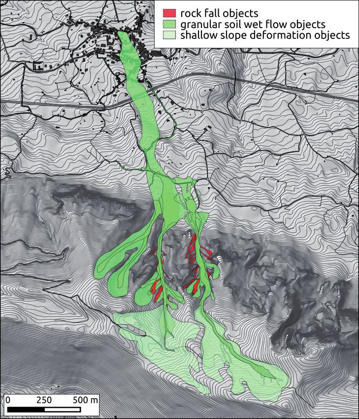
M. Valiante, d. guida, M. della seta & F. bozzano

         Inundation, flow dynamics, and damage in the 9 January 2018 Montecito debris-flow event, California, USA: Opportunities and challenges for post-
         wildfire risk assessment. Geosphere, 15 (4): 1140-1163.
      Naidu S., Sajinkumar K. S., Oommen T., Anuja V. J., Samuel R. A. & Muraleedharan C. (2018) - Early warning system for shallow landslides using
         rainfall threshold and slope stability analysis. Geoscience Frontiers, 9: 1871-1882.
      Perov V., Chernomorets S., Budarina O., Savernyuk E. & Leontyeva T. (2017) - Debris flow hazard for mountain regions of Russia: regional feature
         and key events. Nat. Hazards, 88: S199-S235.
      Roe G.H. (2005) - Orographic Precipitation. Annu. Rev. Earth Planet. Sci. 33: 645-671.
      Southern Appennines Hydrographic District, Ex Left Sele River Basin Authority (2012) - Piano Stralcio per l’Assetto Idrogeologico - PSAI
         (Hydrogeological Setting Plan).
      Valiante M., Guida D., Della Seta M. & Bozzano F. (2020) - A spatiotemporal object-oriented data model for landslides (LOOM). Landslides,
         18 (4):1231-1244.

                                                              Received February 2021 - Accepted June 2021

248   Italian Journal of Engineering Geology and Environment, 1 (2021)       © Sapienza Università Editrice                          www.ijege.uniroma1.it
Puoi anche leggere