MUSAR - DATA FUSION & SMART AUTOMATIC CLASSIFICATION OF SATELLITE MULTISENSOR/MULTIBAND SAR AND OPTICAL DATA - data fusion & smart automatic ...
←
→
Trascrizione del contenuto della pagina
Se il tuo browser non visualizza correttamente la pagina, ti preghiamo di leggere il contenuto della pagina quaggiù
MUSAR - DATA FUSION & SMART AUTOMATIC CLASSIFICATION OF
  SATELLITE MULTISENSOR/MULTIBAND SAR AND OPTICAL DATA

                       Paolo Mazzanti

                    Earth Technology Expo,
                      Firenze 15-10-2021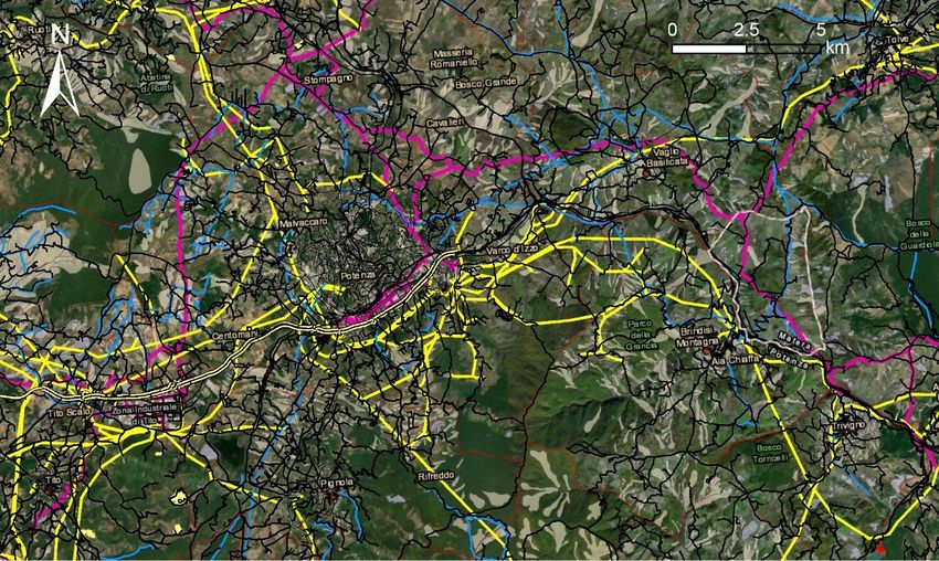
The SPEAKER
                                          Prof. Paolo Mazzanti, “Sapienza” University of Rome
                                          Expert in geotechnical monitoring and remote sensing applied to ground and structures
                                          deformation processes

                                          • MSc in Geology and PhD in Earth Sciences
                                          • Lecturer of Remote Sensing and Geologic Risks at “Sapienza” University of Rome (Italy)
                                          • CERI (Research Center for the Forecast, Prevention and Control of Geological Risks)

                                          • Organizer of the “International Course on Geotechnical and Structural Monitoring”

                                          • Member of the TRB (Transportation Research Board) Engineering Geology Committee
                                          • Member of the Executive Board of the FMGM (Field Measurements in Geomechanics)
                                            community

                                          • Founder and CEO of NHAZCA S.r.l., Startup of “Sapienza” University of Rome.

Fundamentals of Terrestrial SAR Interferometry
                                                                                                                                     2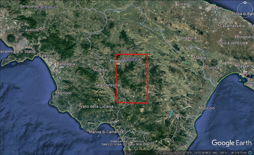
NHAZCA
                                          NHAZCA is a limited company (S.r.l.), Startup of “Sapienza” University of Rome (Italy)
                                          International leader of analysis and monitoring solutions for the management and control
                                          of Infrastructures and Natural Hazards

                                          • Incubated at European Space Agency Business Incubation Centre in 2010
                                          • Integrated team of 30 qualified professionals, researchers and academics

                                          • Core technologies:
                                          Satellite InSAR, Terrestrial InSAR, PhotoMonitoringTM, Laser Scanner, Drones (UAV)
                                          • Serving more than 400 customers from 40 countries

                                          • ISO 9001:2015 Certification

Fundamentals of Terrestrial SAR Interferometry
                                                                                                                                     3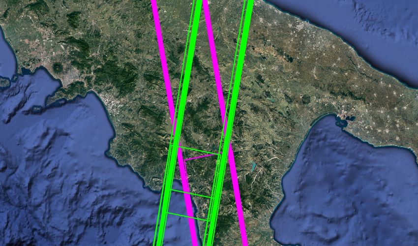
OBIETTIVI
  Estendere lo sfruttamento dei dati EO nell’area di ricerca attinente ai rischi naturali, con particolare attenzione rivolta alle
  strategie di gestione e manutenzione delle infrastrutture viarie e delle opere d’arte stradali

                                                                                                                                     4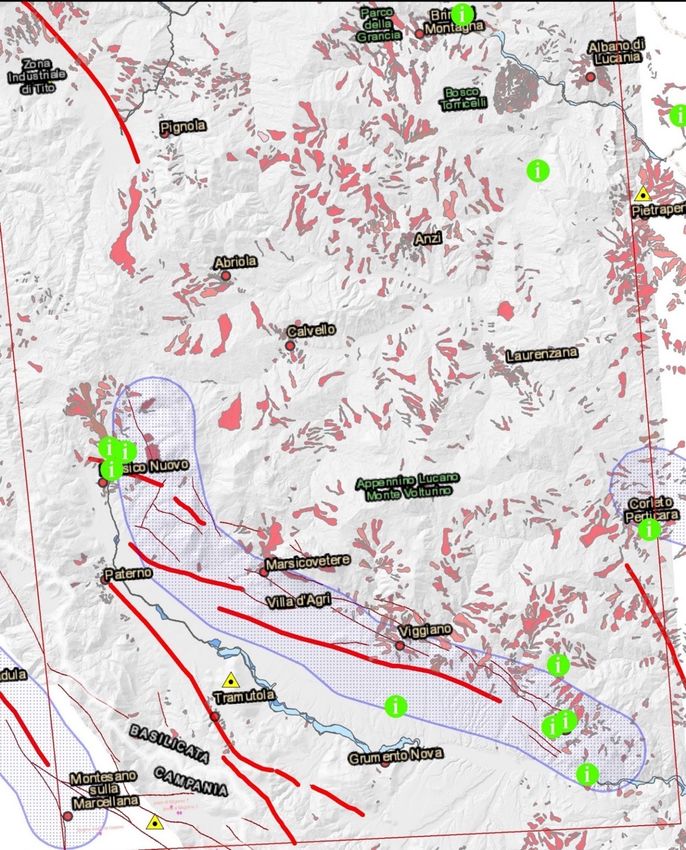
INFRASTRUCTURE ASSET MANAGEMENT

         Problem: Geohazards + Aging infrastructures

      Investment and budget allocation for maintenance, adaptation and safety measures
      • ANAS S.p.A., Italy:                           period 2016-2020, 15,9 billion € (3,8 billion € per year),
      • Autostrade per l’Italia, Italy:               period 2020-2023, 7 billion € (1,75 billion € per year),
      • Colorado Department of Transportation, USA:   period 2021-2022, 972 million $,
      • RFI - Rete Ferroviaria Italiana, Italy:       period 2016-2021, 10,5 billion € (1,75 billion per year),
      • Deutsche Bahn, Germany:                       period 2021-2030, 12.7 billion € (1,2 billion € per year).

         Solution: Predictive maintenance + Asset Management

Fundamentals of Terrestrial SAR Interferometry
                                                                                                                   5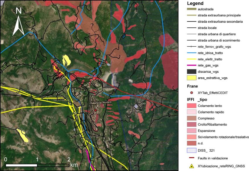
ATTIVITA’
  1. Data Fusion:
       a) Integrazione delle tecniche InSAR Differenziali (DInSAR) e Avanzate (A-DInSAR)
       b) Integrazione dei risultati A-DInSAR multisensore/multifrequenza
       c) Stima del campo di spostamento 3D mediante l’integrazione dei dati SAR e ottici satellitari.
  2. Classificazione smart automatica: basata su metodi di Machine Learning per l’individuazione e classificazione di
  processi naturali e antropici sfruttando risultati di analisi di dati EO

                                                                                                                        6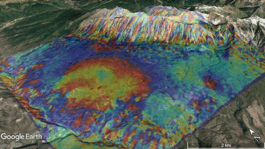
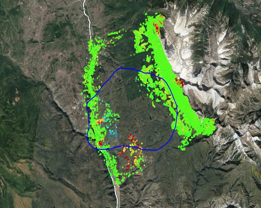
AREA DI STUDIO

Caratterizzato dalla presenza
di differenti tipologie di
processi naturali attivi, dalla
presenza diffusa di diverse
tipologie di frane, da attività
di tipo estrattivo e di
reiniezione (Concessioni ENI Val
D’Agri e Total Gorgoglione) e
infrastrutture di interesse (ad
es. Diga del Pertusillo)

                                   7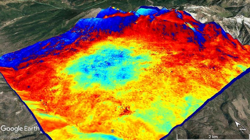
SVILUPPO DATABASE TERRITORIALE

                                 8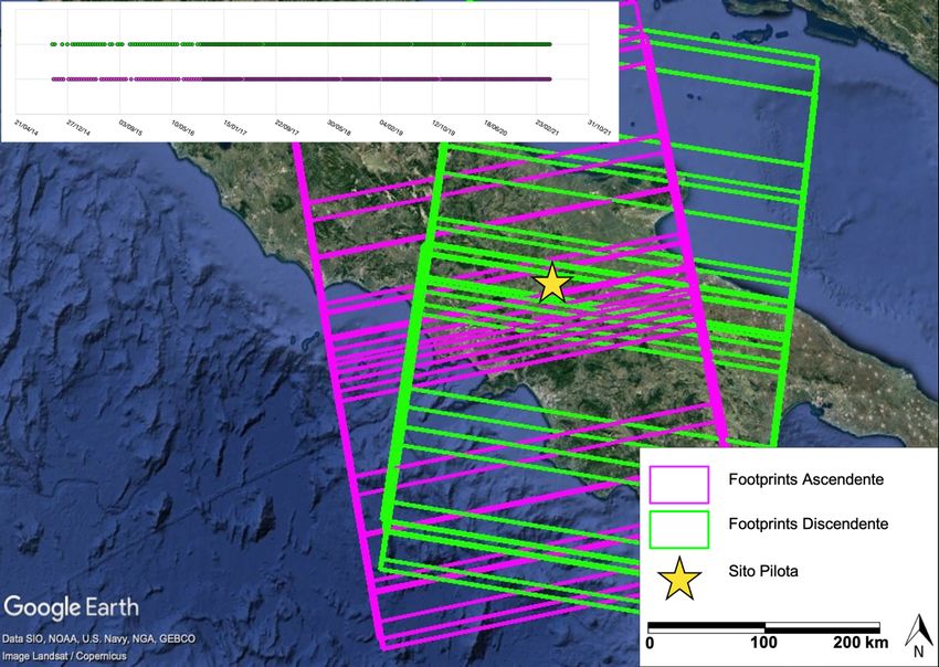
SVILUPPO DATABASE TERRITORIALE

                                 9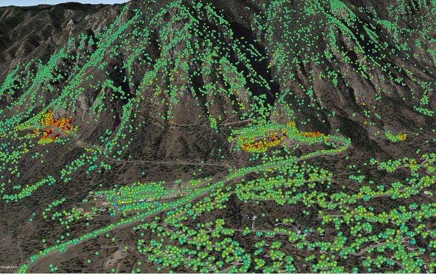
SVILUPPO DATABASE TERRITORIALE
                                 A scala areale sono anche stati consultati i
                                 seguenti cataloghi riferibili a processi naturali
                                 agenti sul territorio
                                 - Inventario dei Fenomeni Franosi (IFFI)
                                 - Aree a rischio frana (AdB Basilicata)
                                 - Inventario Frane Italia (Calvello et al., 2018)
                                 - Catalogo Effetti Deformativi Indotti da Forti
                                   Terremoti (CEDIT)
                                 - Perimetrazioni delle arre inondabili (Tempi
                                   di Ritorno 30, 200 e 500 anni)
                                 - Sinkhole (ISPRA - Regione Campania)
                                 - Faglie Attive e Capaci (ITHACA)
                                 - Sismicità Storica
                                 - Sorgenti Sismogenetiche (DISS v. 3.2.1.)

                                                                                     10
L’IMPORTANZA DEI DATI
SATELLITARI MULTI-
FREQUENZA
Footprint ascendente
• Sentinel-1 (marzo 2014-giugno2021) Footprint discendente
Sito alternativo
0 25 50 km
• COSMO-SkyMed (maggio 2011-luglio 2021)
• SAOCOM (ottobre 2020-agosto 2021)
11Sentinel-1
L’IMPORTANZA DEI DATI • Period: Sept 2019
• C Band
SATELLITARI MULTI- • Resolution: 5x20 m
FREQUENZA
ALOS-2
• Period: 2007 – 2010
• L Band
Fundamentals of Terrestrial SAR Interferometry
• Resolution: 10x10 m 12L’IMPORTANZA DI COMBINARE
INSAR E PHOTOMONITORING
Optical analysis with PhotoMonitoringTM SAR satellite data analysis
10,0 m
MEASURING
POINTS
LOS velocity
Slope remedial (mm/year)
works (5-10
Anthropic
mm/y)
materials (L’IMPORTANZA DEI DATI Sentinel-1
• Period: Sept 2019
SATELLITARI MULTI- R VE
• C Band
E SE
FREQUENZA
• Resolution: 5x20 m
C H
E CIÒ A RI?
ENT ELLIT
RA M I SAT
O VE I DAT
S ON A LI
TE/I FIN
RA NTI
O LO U TE
TI C GLI
/PU N I P ER
PPE T IV
E MA PERA
UEST ERE O
Q
MA ER REND
P
ALOS-2
• Period: 2007 – 2010
Fundamentals of Terrestrial SAR Interferometry • L Band
• Resolution: 10x10 m 14MAGARI QUALCOSA DEL GENERE PUÒ ESSERE PIÙ UTILE?
GROUND DEFORMATION MARKERS
From millimetric up
to centimetric Highway 133
From centimetric up Study Area
to decimetric
Decimetric
0 1 2 km
Fundamentals of Terrestrial SAR InterferometryINSAR PS TOOLBOX Vectorial
decomposition
Trend change detection
NHAZCA
GIS
PS-toolbox
PS on linear
infrastructures
Interferometric sections
Data spatialization
Multi-sensor
Time series
ERS – ENVISAT - COSMO-SkyMed
Fundamentals of Terrestrial SAR InterferometryCLASSIFICATION + INTERPRETATION = UNDERSTANDING & PREDICTION
COSMO-SkyMed
A91 Highway
• Period: Feb 2011 – Dec 2015 Rome-Fiumicino
• X Band
• Resolution: 3x3 m
Data interpretation PEAT
Fundamentals of Terrestrial SAR Interferometry
17
Bozzano et al. 2018. Imaging Multi-Age Construction Settlement Behavior by Advanced SAR Interferometry. Remote Sens. 2018, 10, 1137; doi:10.3390/rs10071137PREDICTION?
Sentinel-1
• Period: May 2015 – May 2017
• C Band
• Resolution: 5x20 m
Fundamentals of Terrestrial SAR Interferometry
18BRIDGING SCIENCE TO………………………………. Fundamentals of Terrestrial SAR Interferometry
BRIDGING SCIENCE TO…………………………………………PRACTICE!

Fundamentals of Terrestrial SAR Interferometry
Puoi anche leggere