MONITORAGGIO DEI CAMBIAMENTI DI COPERTURA DEL SUOLO E DELLE DINAMICHE TERRITORIALI - Michele Munafò - ISPRA
←
→
Trascrizione del contenuto della pagina
Se il tuo browser non visualizza correttamente la pagina, ti preghiamo di leggere il contenuto della pagina quaggiù
MONITORAGGIO DEI CAMBIAMENTI DI
COPERTURA DEL SUOLO E DELLE
DINAMICHE TERRITORIALI
Michele Munafò - ISPRA

                            ROMA, 27 FEBBRAIO 2018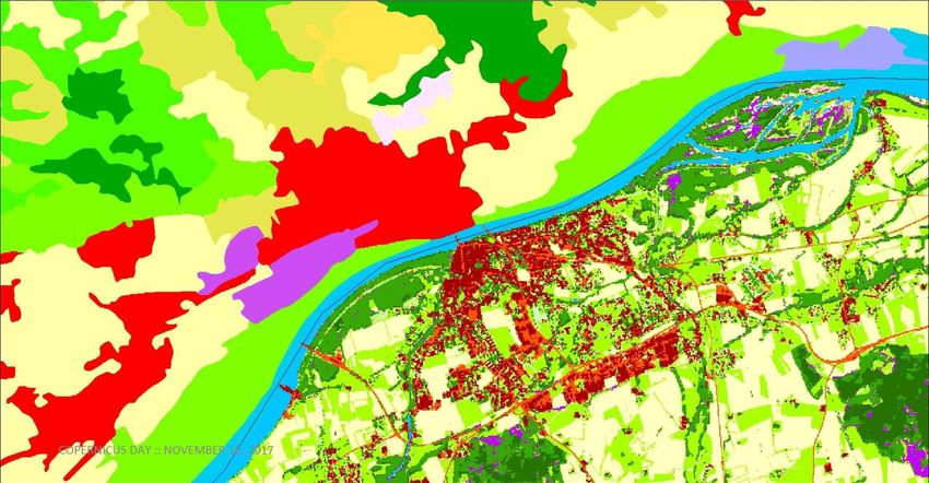
L. 132/2016
Monitoraggio del territorio e del
consumo di suolo (rete ref. SNPA)
IL MONITORAGGIO DEL TERRITORIO
CORINE LAND COVER
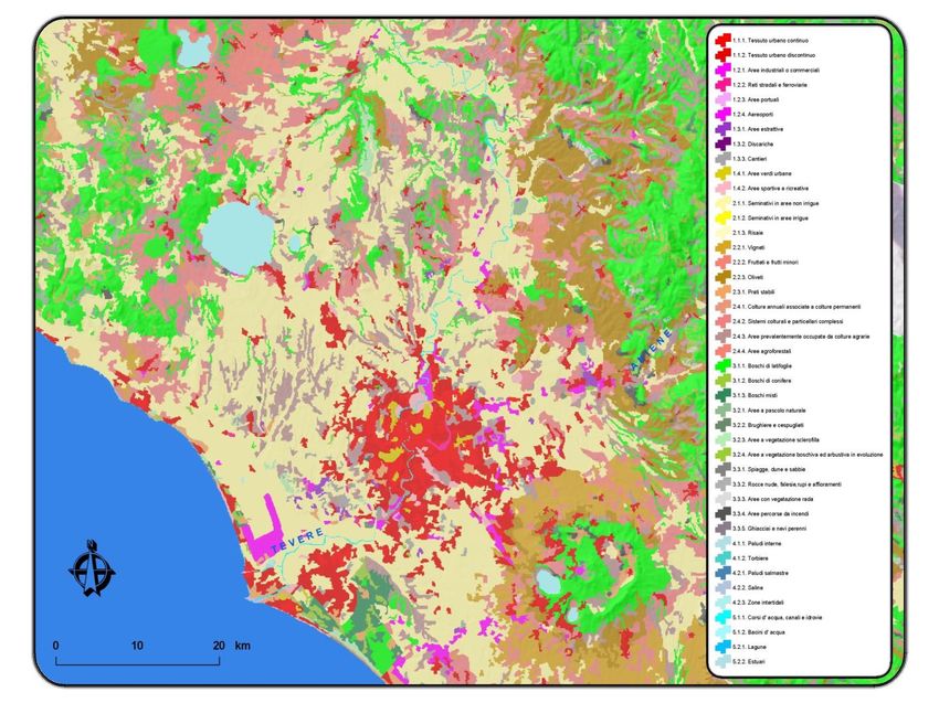
LEGENDA GERARCHICA
                       3 LIVELLI 44 CLASSI
                                1 livello 5 classi
                                                                        Cop       Cop
COD     Descrizione (EN)                  Descrizione (IT)
                                                                       (sup)     (poly)
 1        Artificial areas                Superfici artificiali         5,3%     14,7%
 2       Agricultural areas         Superfici agricole utilizzate      51,7%     43,9%
      Forest and semi-natural    Territori boscati e ambienti semi-
 3                                                                     41,8% 40,5%
                areas                          naturali
 4           Wetlands                        Zone umide                 0,2% 0,3%
 5         Water bodies                      Corpi idrici               1,0% 0,6%

                                                                In Italia: IV livello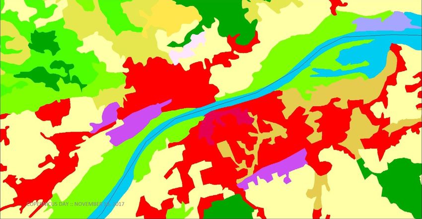
CORINE LAND COVER

COPERNICUS LAND MONITORING SERVICE
L'obiettivo del servizio Land di
Copernicus è quello di fornire agli
utenti del settore dell'ambiente e
applicazioni terrestri informazioni
basate sull’integrazione di dati
satellitari con quelli provenienti da
altre sorgenti.
Il servizio Land indirizza una vasta
gamma di politiche ambientali, tra
cui l'agricoltura, lo sviluppo
regionale, i trasporti e l'energia.

                                         emergency                     marine env.   atmosphere
                                                                                     monitoring   security   climate change
                                        management                     monitoring
                                                     land monitoring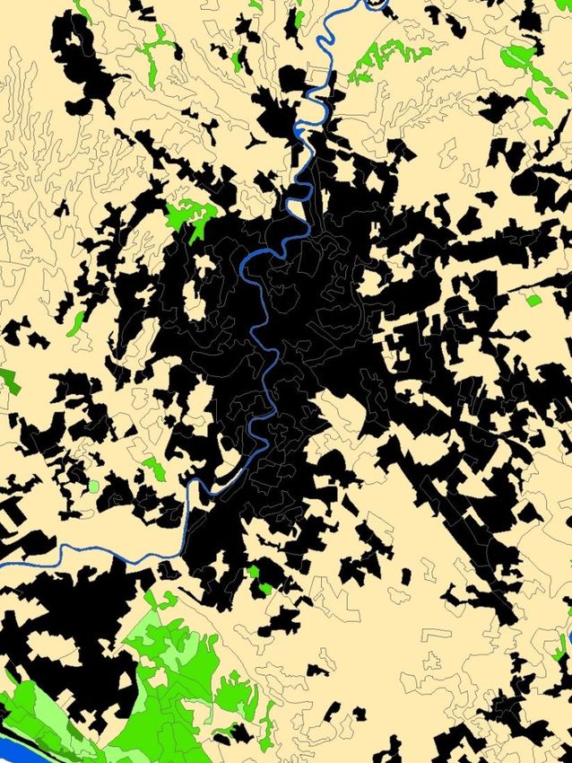
PAN-EU                                      LOCAL

                                            Urban Atlas EU regional policy justifies the
1) Corine Land Cover (1990-2000-2006-       production and maintenance of detailed land
2012-2018*)                                 cover and land use information over major EU city
                                            areas. The Urban Atlas provides pan-European
2) High Resolution Layers                   comparable land use and land cover data covering
  • Imperviousness (2006-2009-2012-2015*-   a number of Functional Urban Areas (FUA). In
                                            2012, an additional layer (Street Tree Layer -
    2018*)                                  STL) was produced for a selection of FUAs.
  • Forest Type and Tree Cover Density      Riparian Zones The next local component
                                            addresses land cover and land use in areas along
    (2012-2015*-2018*)                      rivers, i.e. the riparian zones. The rationale for
                                            this local component is provided by the need to
  • Permanent grasslands (2012-2015*-
                                            monitor biodiversity at European level, amongst
    2018*)                                  other in the framework of improving the “green”
                                            and “blue” infrastructures in the European Union.
  • Wetlands (2012-2015*-2018*)
                                            Natura 2000 The Natura 2000 (N2K) areas are
  • Water bodies (2012-2015*-2018*)         also important hotspots to have in consideration.
                                            The aim of the first N2K project was to assess
                                            whether Natura2000 sites are effectively
                                            preserved and whether a decline of certain
                                            grassland habitat types is halted.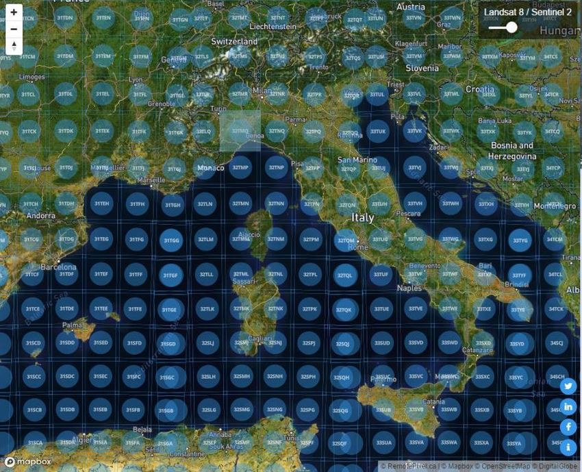
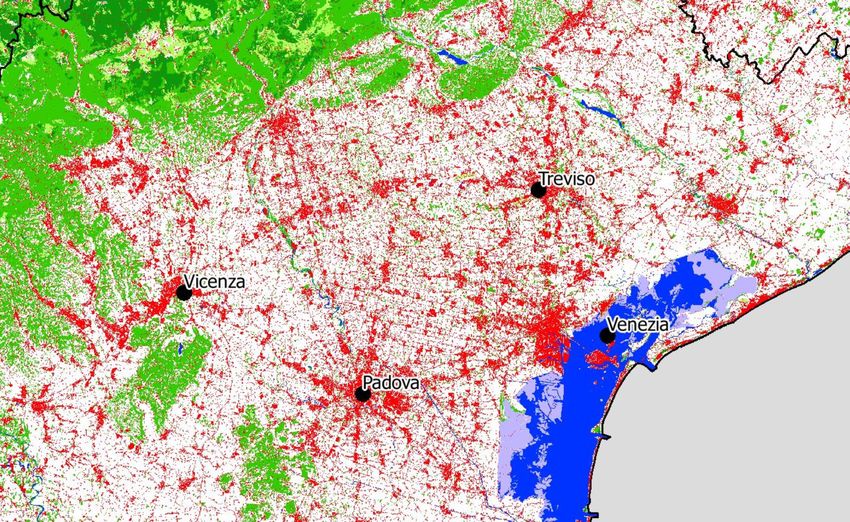
PRINCIPALI DINAMICHE DI TRASFORMAZIONE
           A LIVELLO NAZIONALE

                 9,0                       1990-2012
                             13,3

                     1960-1990       2,8
                                                              da agricolo verso artificiale
        44,7                                                  da naturale verso artificiale
 33,0
                                            53,9              da agricolo verso naturale
                                                              da naturale verso agricolo
                                    39,3

               4,0                                 Entità delle trasformazioni in percentuale sul
                                                   totale dei cambiamenti a livello nazionale
CORINE LAND COVER HIGH RESOLUTION LAYERS
Copernicus EU map

  National map
  (ISPRA/SNPA)
SENTINEL 2
CLASSIFICAZIONE
Confronto multi-
temporale immagini
Satellitari
Sentinel 2A - Torino
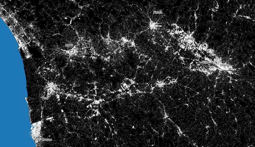
2015-2016DATA COLLECTION E TRATTAMENTO IMMAGINI
ca. 70
Scene/granuli
Sentinel per coprire
l’Italia
6.000
Immagini/anno
4
TeraByte/annoSENTINEL 1
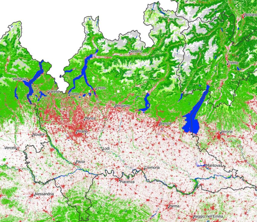
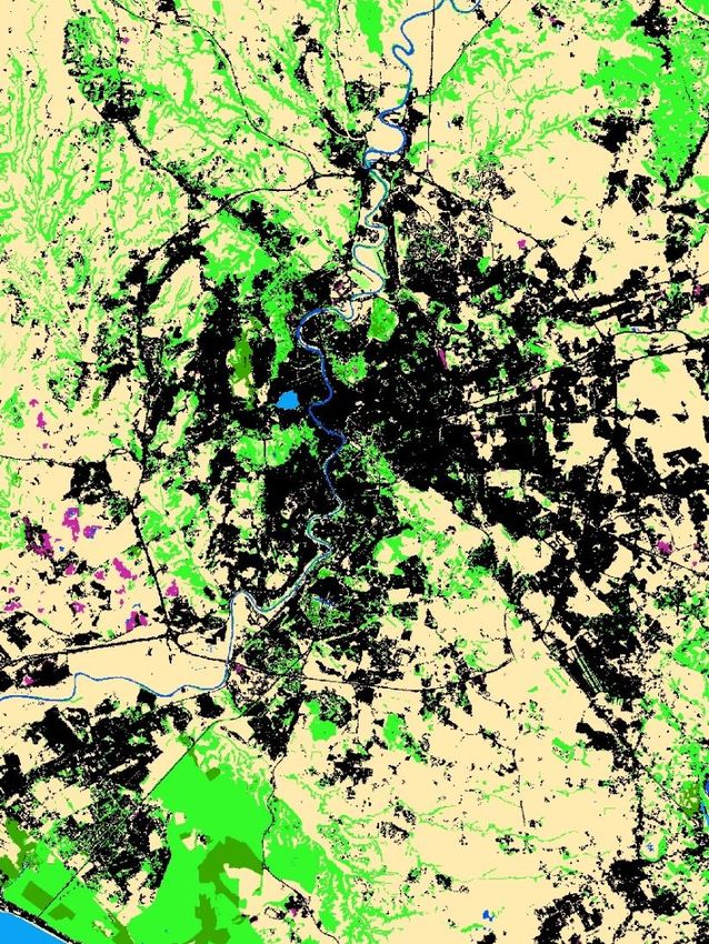
CARTA NAZIONALE DEL CONSUMO DI SUOLO

 Servizio operativo del Sistema Nazionale per la Protezione dell’Ambiente
INDICI VEGETAZIONALI
              NDVI
CARTA NAZIONALE DI COPERTURA DEL SUOLO
PERDITA DI SERVIZI ECOSISTEMICI
                                              Rimozione di    Stoccaggio e
                                              particolato e    sequestro

 630-910
                                                 ozono        del carbonio
                                                                         Qualità degli
                         Regolazione                                       habitat
                            del…
                                             Infiltrazione
                                              dell’acqua
MILIONI DI EURO L’ANNO    Impollinazion
                                e
 I COSTI DOVUTI ALLA
 PERDITA DEI SERVIZI                    Protezione
ECOSISTEMICI A CAUSA                   dall’erosione
   DEL CONSUMO DI
SUOLO AVVENUTO TRA                                              Produzione
    IL 2012 E IL 2016                                            agricola
                             Produzione
                              legnosa
EVOLUZIONE DEL CORINE LAND COVER
HABITAT MAPPING (ASI-ISPRA)
1. Sealed surface (buildings and flat sealed surfaces)   1. Superfici abiotiche non vegetate
2. Woody – coniferous                                    1.1 Superfici artificiali
3. Woody – broadleaved                                   1.2 Superfici naturali
4. permanent herbaceous (i.e. grasslands)                2. Superfici biotiche vegetate
5. Periodically herbaceous (i.e. arable land)            2.1 Vegetazione legnosa
6. Permanent bare soil                                           2.1.1 Latifoglie
7. Non-vegetated bare surfaces (i.e. rock and screes,            2.1.2 Conifere
mineral extraction sites)                                2.2. Vegetazione erbacea
8. Water surfaces                                                2.2.1 Vegetazione erbacea permanente
9. Snow & ice                                                    2.2.2 Vegetazione erbacea periodica
                                                         3. Superfici idriche
                                                                 3.1 Acqua liquida
                                                                 3.2 Acqua solida
                                                         4. Zone umide
Michele Munafò - ISPRA michele.munafo@isprambiente.it @mic_mun
Puoi anche leggere