The urban regeneration in Turin metropolitan city - METREX
←
→
Trascrizione del contenuto della pagina
Se il tuo browser non visualizza correttamente la pagina, ti preghiamo di leggere il contenuto della pagina quaggiù
The urban regeneration in Turin metropolitan city

         Located at the western end of Po Valley, a region famed for centuries of technical
         innovation, Turin specialised in vehicle production and more recently in aerospace. The
         years succeeding World War Two resulted in Italian industry driving the economy and a
strong recovery, referred to by some as the “Italian Miracle”. Thanks to the growth in Fordist-
style production, which radically increased demand for labour and drew internal immigration
from the south of Italy, Turin grew rapidly and sub-urbanised. However, the demand for labour
has since curbed rapidly through globalisation and automation1.

The earlier Fordism crisis, and the massive structural changes in the car industry since then,
have had a decisive impact on industrial development and localisation. Industry has moved
from the city centre to the outskirts and surrounding municipalities of the first two belts (taking
advantage of the accessibility of the ring road).

Over the years the deindustrialisation process, alongside the decentralisation of productive
activities towards more peripheral areas, have resulted in a series of disused sites. This has
been driven by recent crisis where many companies shut down and industries decentralised
(under the increasing fiscal pressure along with strict environmental regulations). These trends
exacerbated the economic dynamic whereby the number of abandoned areas grew
exponentially.

Next to this, the Turin Metropolitan City is stagnating economically and as such, there is no
demand for new industrial spaces. The same applies to the residential development.
Consequently, there is little conflict between manufacturing and other uses.

Therefore, aimed to promote the reuse of many abandoned areas, in the 2019 the Turin
Metropolitan City, in partnership with LINKS Foundation, Confindustria Piemonte and Consorzio
per gli Insediamenti Produttivi del Canavese, promoted the TRENTAMETRO project, a geo
referenced web mapping of 30 abandoned industrial areas present in the metropolitan area,
(http://www.cittametropolitana.torino.it/cms/sviluppo-economico/attrazione-investimenti/trentametro/)

1 ESPON / MISTA - Metropolitan Industrial Spatial Strategy & Economic Sprawl / annex 3.5: case study report Turin
(IT)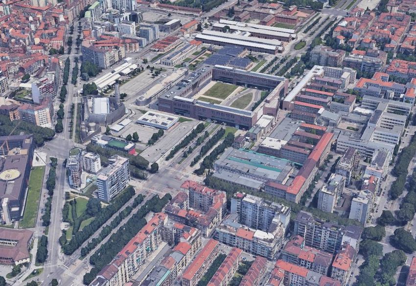
Strong changes have also occurred at the urban level. The decline of the iron and steel industry
that began in the 1970s, the closure of the factories and the interruption of the flow of
immigrants, forced the city of Turin to rethink its urban planning.
The railway axis, once functional to the industrial sector, thus became a wound that divided the
city in two parts, now dotted with abandoned areas and low-quality architecture.
In 1986, at the same time as the reorganization and rationalization of the State Railways, the
studies for the new General Regulatory Plan (PRG) identified the disused areas as the nerve
centres of a new system supported by a central spine around which the entire urban layout
would be redefined. Thus, the 1995 PRG made the redevelopment of the railroad tracks and of
over 3 million square meters of brownfields the distinctive action of the functional plan for the
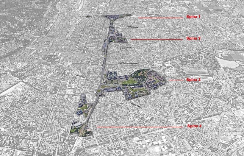
rebuilding of the city. The great redevelopment project of the 13 km of railway line, called Spina
Centrale, is divided into 4 tranches or Spine and provides a large boulevard creation. The Spina
Centrale, is intended for vehicular and public transport, on the side of parking lots with flush
and green areas, while in the outer part, museums, libraries, residences, commercial and green
areas.
The Spina 1 is realized between 1995 and 2000 with the burying of the railway and the realization
of a big urban planted avenue, parking lots and bicycle-pedestrian areas. On the Spina 1 the
Fountain of Mario Merz is one of the 11 works of art present on the route.
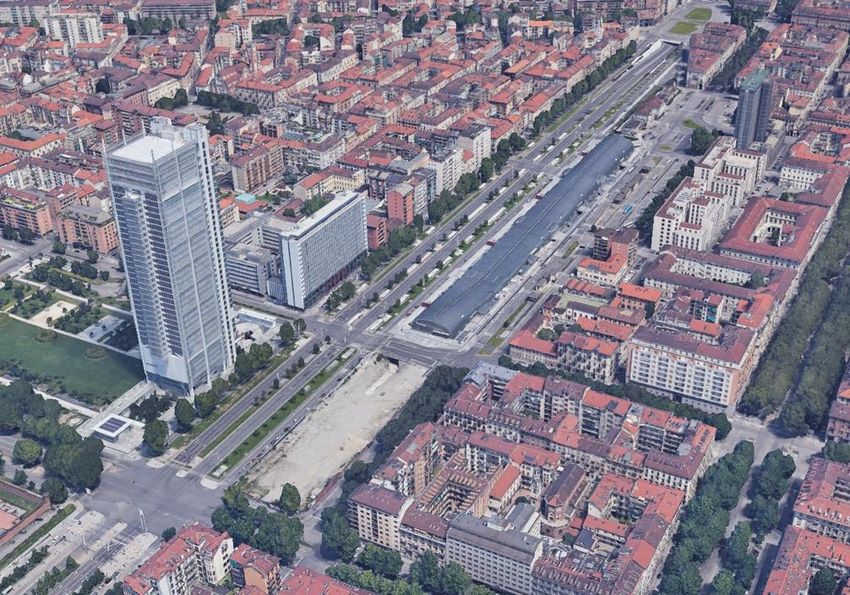
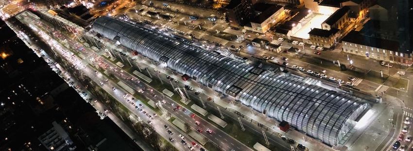
The Spina 2 is characterized not only by the continuation of the boulevard and the realization of
the new Porta Susa station, but also by predominantly cultural functions such as the recovery of
the former OGR (Officine Grandi Riparazioni), the doubling of the Polytechnic of Turin, including
a university campus used by the press during the 2006 Olympics. The bicycle and pedestrian
connections with the existing gardens are strengthened. In 2003 was realized the garden "Caduti
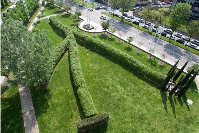
di Cefalonia e Corfù" by the artist Giuseppe Penone, characterized by a green triangle in which a
tunnel of shaped hornbeams draws the ribs of a leaf with a water basin at the top surrounded
by cypresses, an olive tree and a poplar.
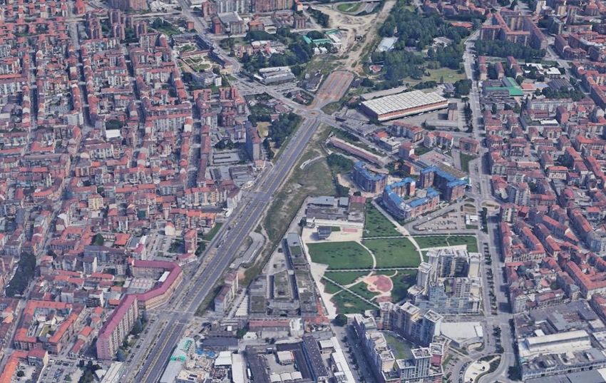
The Spina 3 is the stretch where the railway underpasses the Dora River. In this section there are
commercial functions, advanced productive functions (Environmental Park) and residential
functions around the Dora Park, the heart of the green of the entire re-qualification project.
Spina 4 has mainly residential functions and hosts the Rebaudengo station, the first one to
arrive from Milan and connected to subway lines built on disused rail routes.
In addition to these 4 Spines, there is also the Spina Reale, located at the intersection of spines
3 and 4. It is a promenade planted with Mediterranean plants placed in brick niches that delimit
an elevated pedestrian and bicycle path towards Venaria Reale.
Spina Centrale sub-
divided in 4 tranches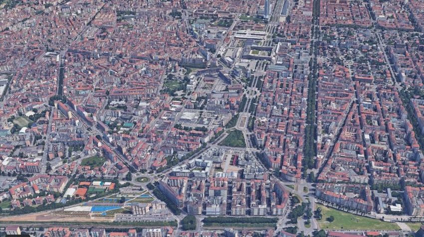
Situata all'estremità occidentale della Pianura Padana, una regione famosa per secoli di
        innovazione tecnica, Torino si è specializzata nella produzione di veicoli e più
recentemente nel settore aerospaziale. Gli anni successivi alla seconda guerra mondiale
portarono l'industria italiana a guidare l'economia e a una forte ripresa, definita da alcuni come
il "miracolo italiano". Grazie alla crescita della produzione in stile fordista, che aumentò
radicalmente la domanda di lavoro e attirò l'immigrazione interna dal sud Italia, Torino crebbe
rapidamente e si suburbanizzò. Tuttavia, la domanda di manodopera si è poi ridotta
rapidamente grazie alla globalizzazione e all'automazione.

La precedente crisi del fordismo, e i massicci cambiamenti strutturali nell'industria
automobilistica da allora, hanno avuto un impatto decisivo sullo sviluppo industriale e sulla
localizzazione. L'industria si è spostata dal centro della città alla periferia e ai comuni limitrofi
delle prime due cinture (approfittando dell'accessibilità della tangenziale) .

Nel corso degli anni il processo di deindustrializzazione insieme al decentramento delle attività
produttive verso aree più periferiche hanno portato ad una serie di siti dismessi. Questo è stato
spinto dalla recente crisi in cui molte aziende hanno chiuso e le industrie si sono
decentralizzate (sotto la crescente pressione fiscale insieme a severe normative ambientali).
Queste tendenze hanno esacerbato la dinamica economica per cui il numero di aree
abbandonate è cresciuto esponenzialmente.

Accanto a questo, la Città Metropolitana di Torino è economicamente stagnante e come tale non
c'è domanda di nuovi spazi industriali. Lo stesso vale per lo sviluppo residenziale. Di
conseguenza, c'è poco conflitto tra la produzione e gli altri usi.

Pertanto, nell'intento di promuovere il riuso di molte aree dismesse, nel 2019 la Città
Metropolitana di Torino, in partnership con la Fondazione LINKS, Confindustria Piemonte e
Consorzio per gli Insediamenti Produttivi del Canavese, ha promosso il progetto TRENTAMETRO,
una mappatura web georeferenziata di 30 aree industriali dismesse presenti nell'area
metropolitana, (http://www.cittametropolitana.torino.it/cms/sviluppo-economico/attrazione-
investimenti/trentametro/)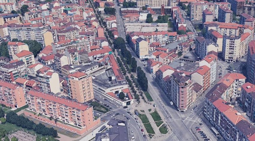
Anche al livello urbanistico si sono registrati forti cambiamenti. Il declino del settore siderurgico
iniziato negli anni ’70, la chiusura degli stabilimenti e l’interruzione del flusso migratorio ha
costretto la città di Torino a ripensare al proprio assetto urbanistico.

L’asse ferroviario, un tempo funzionale al comparto industriale, diventa così una ferita che
divide in due la città ormai costellata da aree dismesse e architetture di bassa qualità.
Nel 1986, contestualmente alla riorganizzazione e razionalizzazione delle Ferrovie dello Stato, gli
studi del nuovo Piano Regolatore Generale individuano nelle aree dismesse i gangli di un nuovo
sistema sorretto da una Spina centrale attorno alla quale sarà ridefinito l’intero assetto
urbanistico. Così il PRG del 1995 fa della riqualificazione del tracciato ferroviario e di oltre 3
milioni di mq di brownfields, l’azione distintiva del Piano funzionale alla ricucitura della città. Il
grande progetto di riqualificazione dei 13 km di linea ferroviaria, denominato Spina Centrale, è
articolato in 4 tranches o spine e prevede la realizzazione di un grande boulevard. La Spina
Centrale, viene destinata al trasporto veicolare e pubblico, a lato parcheggi con sistemazioni a
raso e verde, mentre nella parte più esterna, musei, biblioteche, residenze, terziario e aree verdi.

La Spina 1 viene realizzata tra il 1995 ed il 2000 con l’interramento della ferrovia e la
realizzazione di un grande viale urbano piantumato, parcheggi e aree ciclopedonali. Sulla Spina
1 la Fontana di Mario Merz è una delle 11 opere d’autore presenti sul tracciato.
La Spina 2 è caratterizzata oltre che dalla continuazione del boulevard e dalla realizzazione della
nuova stazione di Porta Susa, anche da funzioni prevalentemente culturali come il recupero
delle ex – OGR, il raddoppio del Politecnico di Torino, compreso un campus universitario
utilizzato dalla stampa durante le Olimpiadi del 2006. Vengono rafforzati i collegamenti
ciclopedonali con i giardini esistenti. Nel 2003 viene realizzato il giardino Caduti di Cefalonia e
Corfù ad opera dell’artista Giuseppe Penone caratterizzato da un triangolo verde spartitraffico in
cui un tunnel di carpini sagomati disegnano le nervature di una foglia con al vertice una vasca
d’acqua contornata da cipressi, un ulivo ed un pioppo.
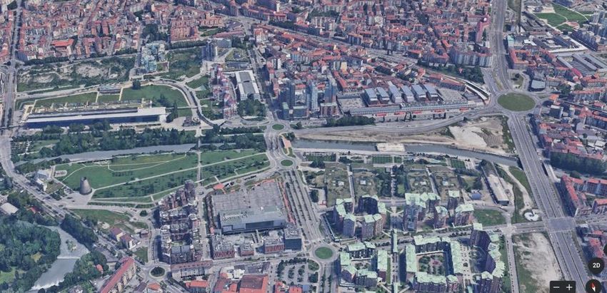
La Spina 3 è il tratto in cui la ferrovia sottopassa il Fiume Dora. In questo tratto sono presenti
funzioni commerciali, funzioni produttive avanzate (Environmental park) e funzioni residenziali
attorno al Parco Dora, cuore del verde dell’intera Spina.
La Spina 4 ha funzioni prevalentemente residenziali ed ospita la stazione Rebaudengo, la prima
che arriva da Milano e connessa a linee metropolitane realizzate su percorsi ferroviari dismessi.

Alle 4 spine si aggiunge inoltre la cd. Spina Reale, situata all’incrocio tra le spine 3 e 4. Si tratta
di una promenade plantée con piante mediterranee messe in nicchie di mattoni che delimitano
un percorso ciclopedonale soprelevato in direzione Venaria Reale.

                                                                                         La Spina
                                                                                         Centrale
                                                                                         suddivisa in 4
                                                                                         tranches.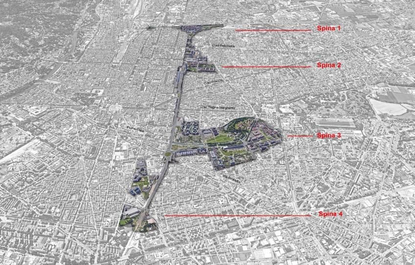
3d Google Earth image: Spina 1, Mario Merz fontana, boulevard.

3d Google Earth image. Spina 2: OGR site, Politecnico di Torino, Garden "Caduti di Cefalonia e Corfù", boulevardn
3d Google Earth image. Spina 2: Porta Susa Station, San Paolo skyscraper, boulevard.

3d Google Earth image. Spina 3: railpass under Dora River, Environment Park, residential and commercial area, Dora Park .
3d Google Earth image. Spina 4. Residential area, Rebaudengo Station

3d Google Earth image. Spina Reale.
Igloo Fontain
     by the artist Mario Merz

Caduti di Cefalonia e Corfù" Garden by the artist Giuseppe Penone

                                          Intesa San Paolo bank skyscreper

Porta Susa station.
Puoi anche leggere