Management for disaster Satellite images - dei disastri - JRC Publications Repository
←
→
Trascrizione del contenuto della pagina
Se il tuo browser non visualizza correttamente la pagina, ti preghiamo di leggere il contenuto della pagina quaggiù
Satellite images
 for disaster
management
 Le immagini satellitari
 per la gestione
       dei disastri

          Joint
          Research
          Centre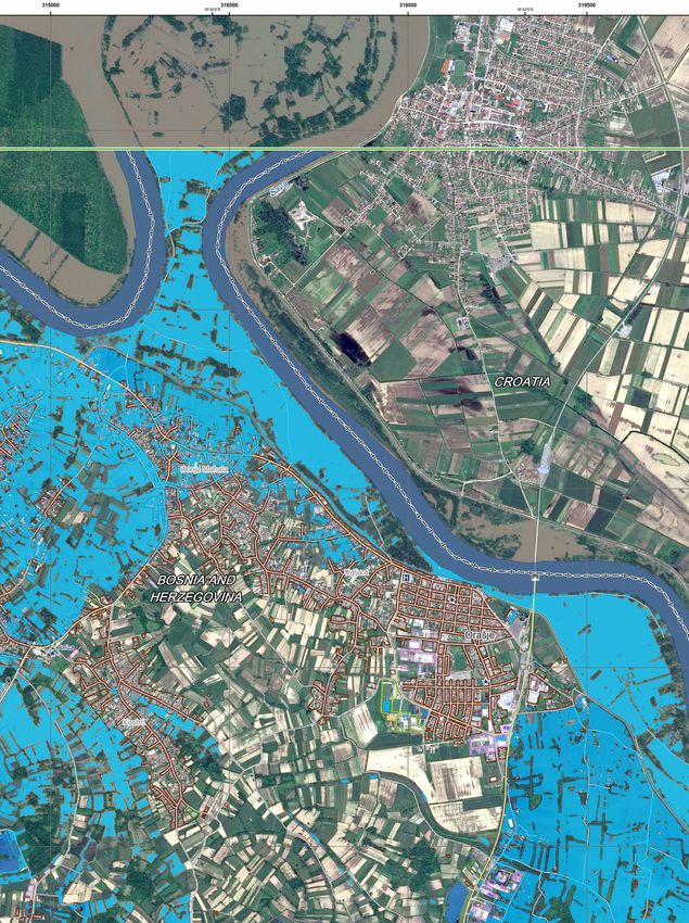
Luxembourg: Publications Office
of the European Union, 2016
© European Union, 2016
Reproduction is authorised provided
the source is acknowledged.
Printed in Italy.

PDF                         Print
ISBN 978-92-79-56986-9      ISBN 978-92-79-56985-2
                            doi:10.2760/077338
                            KJ-02-15-955-2K-C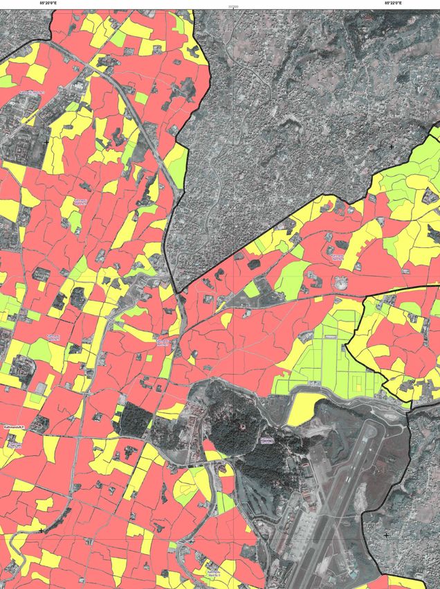
Satellite images
               for disaster
    management
               Le immagini satellitari
               per la gestione
                                       dei disastri
Satellite data play an essential role in disaster risk management.   I dati satellitari giocano un ruolo importante nella
For example, when a disaster occurs, based on the analysis           gestione dei disastri. Ad esempio, quando avviene
                                                                     una catastrofe naturale o una crisi, analizzando le
of pre- and post-disaster satellite data, emergency responders       immagini satellitari prese prima e dopo il disastro,
can get an overall picture of what has happened, where, and          tutti gli attori coinvolti nella gestione dell’emer-
the characteristics, extent and severity of the damage. Satellite-   genza possono avere un quadro generale di quello
derived information can also be used to inform decisions and         che è successo, dove è successo e le caratteristi-
                                                                     che, l’estensione e la gravità dei danni. Le informa-
plan actions for disaster prevention as well as recovery and
                                                                     zioni derivate dalle immagini satellitari possono
reconstruction.                                                      essere usate sia per la prevenzione dei disastri,
                                                                     sia per la gestione dell’emergenza e le attività di
The JRC is responsible for the technical, scientific and contrac-    ricostruzione.
tual coordination of the Emergency Management Service (EMS)
                                                                     Il JRC è responsabile per il coordinamento tecnico,
of the Copernicus programme, the European Earth Observation          scientifico e contrattuale del Servizio di Gestione
programme.                                                           dell’Emergenza (EMS) del Programma Copernicus,
                                                                     il progamma europeo per l’osservazione della Terra.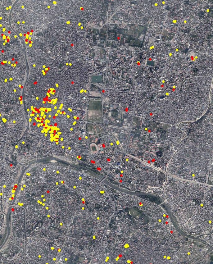
SATELLITE IMAGES FOR DISASTER MANAGEMENT ~ LE IMMAGINI SATELLITARI PER LA GESTIONE DEI DISASTRI
The Copernicus Il Servizio di Gestione dell’Emergenza
di Copernicus
Emergency In caso di disastri naturali, emergenze causate
dall’uomo e crisi umanitarie, il Servizio di Gestione
Management Service dell’Emergenza (EMS) del programma Copernicus
fornisce rapidamente a tutti gli attori coinvolti ac-
curate informazioni geo-spaziali derivate da im-
magini satellitari. Tali informazioni sono integrate
da dati disponibili in loco e da dati liberamente
The Copernicus Emergency Management Service (EMS) provides
disponibili (open source). L’EMS è attivo in caso
actors involved in the management of natural disasters, hu- di disastri nazionali o trans-nazionali in Europa
man-induced emergency situations, and humanitarian crises e in caso di gravi disastri al di fuori dell’Unione
with timely and accurate geo-spatial information derived from Europea.
satellite imagery, complemented by available in-situ (non-
L’EMS offre alle autorità nazionali che si occupano
space) and open source data. The EMS responds to national della gestione dei disastri diversi servizi: allerta
and cross-border disasters in Europe and large-scale disasters precoce, mappatura rapida e mappatura per la
outside of the EU. riduzione del rischio e per la ricostruzione dopo
un disastro.
The EMS offers various services to national authorities dealing
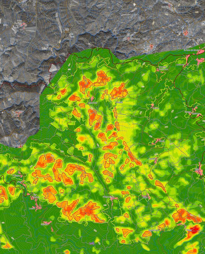
Per esempio, questa immagine mostra l’analisi
with disaster risk management: early warning as well as rapid, dell’impatto di diversi incendio boschivi avvenuti
risk and recovery mapping. in Portogallo. Tale analisi aiuta la pianificazione di
attività post-disastro, ad esempio interventi per la
For example, this map shows a forest fire impact analysis for stabilizzazione dei pendii, l’accesso alle aree col-
pite e la valutazione dell’erosione.
planning recovery actions in Portugal after the occurrence of
several forest fires; analysis support actions aimed at the sta-
bilization of slopes, access to affected areas and assessment
of erosion.
Forest fire impact analysis in Portugal
Analisi dell’impatto di un incendio boschivo in Portogallo
Legend ~ Legenda
Crisis information Erosion G factor,
Informazioni sulla crisi Susceptibility
Fire extent Fattore G di erosione,
Estensione Vulnerabilità
del fuoco 0 - 0.5, Very low
0 - 0.5, Molto basso
Erosion information 0.5 - 1, Very low
Informazione 0.5 - 1, Molto basso
sull’erosione
1 - 1.5, Low
Erosion gradient 1 - 1.5, Basso
Gradiente
1.5 - 2, Low
di erosione
1.5 - 2, Basso
2 - 2.5, Low
2 - 2.5, Basso
2.5 - 3, Low
2.5 - 3, Basso
3 - 3.5, Moderate
3 - 3.5, Moderato
3.5 - 4, Moderate
3.5 - 4, Moderato
4 - 4.5, Moderate
4 - 4.5, Moderato
4.5 - 5, High
4.5 - 5, Alto
5 - 5.5, High
5 - 5.5, Alto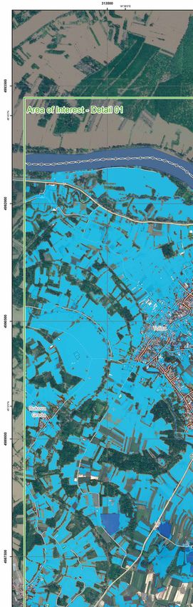
SATELLITE IMAGES FOR DISASTER MANAGEMENT   ~   LE IMMAGINI SATELLITARI PER LA GESTIONE DEI DISASTRI

Serra de Caramulo
Erosion risk map
Detail 3
SATELLITE IMAGES FOR DISASTER MANAGEMENT ~ LE IMMAGINI SATELLITARI PER LA GESTIONE DEI DISASTRI
Preventing
and preparing
for disasters
Satellite-based maps can be very useful to support prevention
and preparedness activities. For example, they can provide
information on the exposure and vulnerability of people and
buildings.
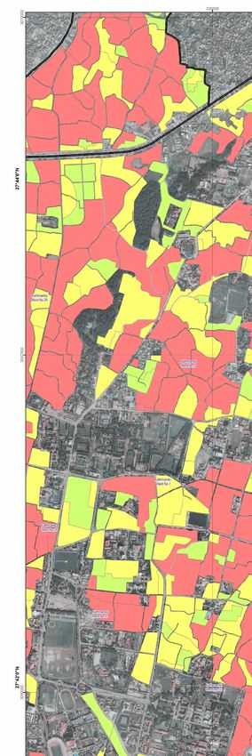
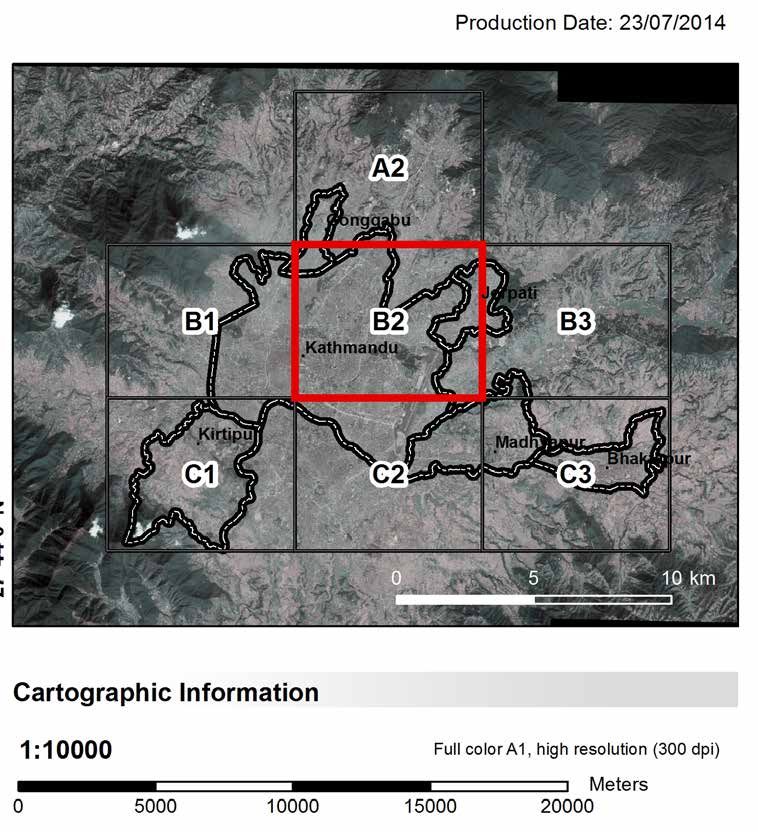
This map covers the districts of Kathmandu, in Nepal and shows
the vulnerability of the population (high, red areas - medium,
yellow areas and low, green areas). This vulnerability has been
determined using two different inputs: vulnerability of the build-
ing blocks and population estimates for each building block
by assigning an average number of families to each building
and a household size.
Prevenire e prepararsi
a gestire i disastri
Le mappe basate sulle immagini satellitari pos-
sono essere molto utili in supporto alle attività
di prevenzione e preparazione. Ad esempio, esse
possono fornire informazioni sull’esposizione e la
vulnerabilità delle persone e degli edifici. Questa
mappa mostra la vulnerabilità della popolazione
nei distretti di Kathmandu, in Nepal: le aree in
rosso sono ad alta vulnerabilità, quelle in giallo
a media vulnerabilità e quelle in verde a bassa
vulnerabilità. La vulnerabilità è stata determinata
usando due elementi: la vulnerabilità degli edifici
in ciascun isolato e una stima della popolazione
che ci vive, assegnando un numero medio di fa-
miglie che vivono in ogni edificio e la dimensione
di ogni famiglia.
Legend ~ Legenda
Population Vulnerability
Vulnerabilità della popolazione
Low
Bassa
Medium
Media
High
Alta
Administrative limits
Limiti amministrativi
Population vulnerability
Municipalities in Kathmandu, Nepal
Comuni Vulnerabilità
Wards della popolazione
Quartieri a Kathmandu, Nepal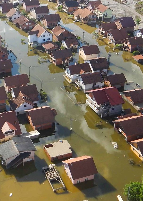
SATELLITE IMAGES FOR DISASTER MANAGEMENT   ~   LE IMMAGINI SATELLITARI PER LA GESTIONE DEI DISASTRI

                                                  Kathmandu - Bhaktapur
                                                  Population Vulnerability
                                                  2014 - Detail 10k Sheet B2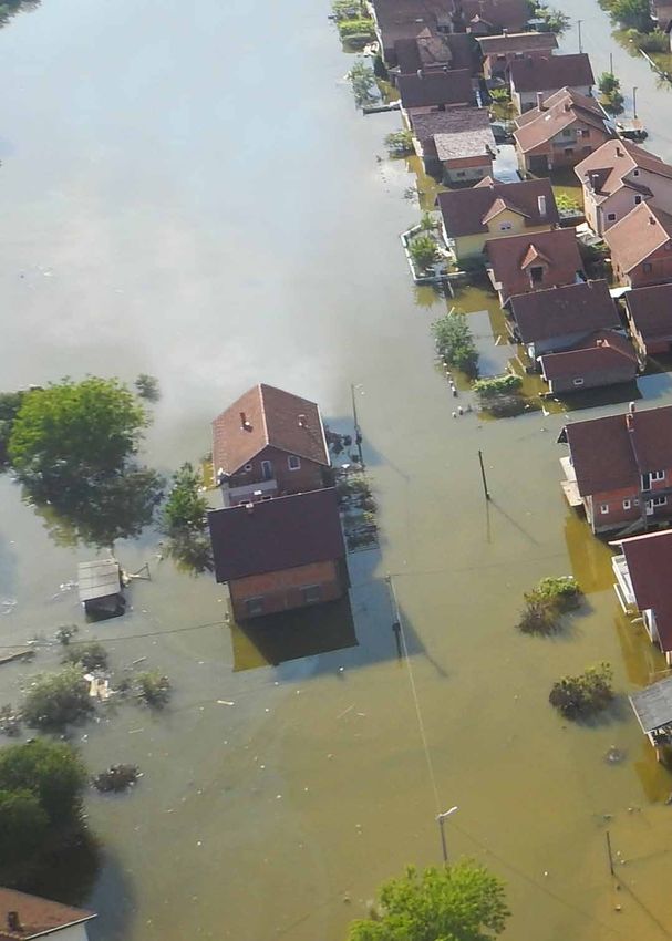
SATELLITE IMAGES FOR DISASTER MANAGEMENT    ~    LE IMMAGINI SATELLITARI PER LA GESTIONE DEI DISASTRI

Dealing with
emergencies
After a catastrophic event, such as earthquakes, tsunamis,
floods, severe storms, as well as humanitarian crises, the Co-
pernicus Emergency Management System (EMS) can deliver
emergency response relevant maps and analyses within few
hours. To do so, the EMS rapidly acquires and processes pre and
post-event satellite imagery and analyses them together with
other geo-spatial data. Maps can indicate, for example, burnt
or flooded areas, or the damage extent due to an earthquake.
These maps can also provide an assessment of the impact                             Gestire l’emergenza
of damages caused by a disaster, which in turn can help first
                                                                                    Dopo un evento catastrofico, come un terremoto,
responders to prioritise intervention actions.                                      uno tsunami, un’inondazione, un uragano e anche
                                                                                    dopo una crisi umanitaria, il Servizio di Gestione
This map shows the damage extent in the city of Kathmandu,                          dell’Emergenza (EMS) di Copernicus può fornire
Nepal, after it was struck by a 7.8 magnitude earthquake in                         mappe e analisi nell’arco di poche ore. Per fare
April 2015.                                                                         ciò, l’EMS acquisisce e processa rapidamente le
                                                                                    immagini satellitari e le analizza insieme ad altri
                                                                                    dati geo-spaziali. Tali mappe possono indicare, ad
                                                                                    esempio, le aree incendiate o inondate, oppure le
                                                                                    aree colpite da un terremoto. Confrontando le im-
                                                                                    magini satellitari prese prima e dopo il disastro,
                                                                                    queste mappe possono anche fornire una valuta-
                                                                                    zione dell’impatto dell’evento o della severità dei
                                                                                    danni causati, aiutando quindi i gestori dell’emer-
                                                                                    genza ad identificare i luoghi dove il loro intervento
                                                                                    deve essere prioritario.
                                                                                    Questa immagine mostra l’estensione dei dan-
Did you know…                                                                       ni agli edifici nella città di Kathmandu, Nepal, a
                                                                                    seguito del terremoto dell’aprile 2015.

Between 2012 and 2014 the Coperni-
cus Emergency Management service
– ‘Rapid Mapping Component’ – has
been activated more than 120 times
and produced more than 1200 maps.

Sapevi che…
Tra il 2012 e il 2014 il Servizio di Gestione                                       Damage extent in Kathmandu, Nepal, after the April
dell’Emergenza di Copernicus – “componente                                          2015 earthquake
di mappatura rapida” – è stato attivato più di                                      Estensione dei danni a Katmandhu, Nepal, a seguito
120 volte e ha prodotto più di 1200 mappe.                                          del terremoto dell’aprile 2015
                                                                                    728 Destroyed buildings
                                                                                    728 edifici distrutti
                                                                                    2164 Possibly affected buildings
                                                                                    2164 probabili edifici colpiti

                                                                                    Legend ~ Legenda

                                                                                            Completely destroyed
                                                                                            Completamente distrutto
                                                                                            Negligible to slight damage
                                                                                            Danni lievi o trascurabili
SATELLITE IMAGES FOR DISASTER MANAGEMENT ~ LE IMMAGINI SATELLITARI PER LA GESTIONE DEI DISASTRI
SATELLITE IMAGES FOR DISASTER MANAGEMENT         ~   LE IMMAGINI SATELLITARI PER LA GESTIONE DEI DISASTRI

Recovering
from a disaster
Satellite images can help to plan post-disaster recovery and
reconstruction initiatives. By comparing satellite images taken
at different intervals. they can also help to monitor the progress
of reconstruction and recovery projects.

In May 2014 heavy rains in Bosnia and Herzegovina caused
sudden and severe flooding and landslides over one third of
the country, affecting more than one million people. The Bosnia
and Herzegovina government, together with the World Bank,
the European Union and the United Nations conducted a Post-
Disaster Needs Assessment (PDNA) to identify damages, losses
and needs, and to estimate recovery costs. The JRC, together
with the international partners, contributed to the PDNA by pro-
viding flood damage analysis and maps through the Coperni-
cus Emergency Management Service and by conducting data
collection and rapid in-field mapping.

La ricostruzione dopo un disastro
Le immagini satellitari possoso essere utili anche
dopo una catastrofe per pianificare le attività di
ricostruzione. Confrontando immagini prese in mo-
menti diversi, si può anche monitorare l’andamen-
to dei progetti di ricostruzione.

Nel maggio 2014 le forti piogge cadute in Bosia e
Erzegovina hanno causato un’improvvisa e grave
inondazione e delle frane su un terzo del paese,
colpendo più di un milione di persone. Il governo
nazionale, insieme alla Banca Mondiale, all’Unione
Europea e alle Nazione Unite ha condotto una “va-
lutazione dei bisogni post-disastro” per identificare
i danni, le perdite e i bisogni e per stimare i costi
per la ricostruzione. Il JRC, insieme agli altri partner
internazionali, ha contribuito a questa valutazio-
ne fornendo delle mappe dell’inondazione attra-
verso il Servizio di Gestione dell’Emergenza di Co-
pernicus e raccogliendo rapidamente dati in loco.

Legend ~ Legenda

Crisis information
Informazioni sulla crisi
        Flooded Area in Bosnia
        Area inondata in Bosnia                              Post disaster needs
                                                             assessment after the
Hydrology                                                    2014 floods in Bosia
Idrologia                                                    and Herzegovina
                                                             Valutazione dei danni
        Lake                                                 post-disastro a seguito
        Lago                                                 dell’inondazione
        River                                                del 2014 in Bosia
        Fiume                                                e Erzegovina
SATELLITE IMAGES FOR DISASTER MANAGEMENT ~ LE IMMAGINI SATELLITARI PER LA GESTIONE DEI DISASTRI
Orasje - Bosnia and Herzegovina
Flood - 13/05/2014
Delineation Map - Detail 01KJ-02-15-955-2K-N
SATELLITE IMAGES FOR DISASTER MANAGEMENT ~ LE IMMAGINI SATELLITARI PER LA GESTIONE DEI DISASTRI
JRC Mission
As the Commission’s
in-house science service,
the Joint Research Centre’s
mission is to provide EU
policies with independent,
evidence-based scientific
and technical support
throughout the whole
policy cycle.
Working in close
cooperation with policy
Directorates-General,
the JRC addresses key
societal challenges while
stimulating innovation
through developing new
methods, tools and
standards, and sharing
its know-how with
the Member States,
the scientific community
and international partners.
Serving society
Stimulating innovation
Supporting legislation
JRC Science Hub: ec.europa.eu/jrc
ISBN 978-92-79-56986-9
doi:10.2760/206608Puoi anche leggere